We found 108737 price guide item(s) matching your search

Refine your search

Year

Filter by Price Range
  • List
  • Grid
  • 108737 item(s)
    /page

Lot 24

Collot, George Henri Victor (French, 1750-1805), "Road from Limestone to Frankfort in the state of Kentucky", Plate 22, engraved map, from Voyages dans l'Amerique Septentrionale..., Paris, 1826 (printed 1804), 14 3/4 in. x 14 5/8 in., linen backed. Provenance: Gaspar Cusachs, entrepreneur, historian and collector, (1855-1929); The Gaspar Cusachs Collection, loaned to the Louisiana State Museum, New Orleans, LA (c. 1909-2016).

Lot 180

Pocket Map of Washita [Ouachita] Parish, Louisiana, 1860, McCerren, Landry & Powell, hand-colored, folded, with original cover, 29 3/4 in. x 39 1/2 in. Provenance: Gaspar Cusachs, entrepreneur, historian and collector, (1855-1929); The Gaspar Cusachs Collection, loaned to the Louisiana State Museum, New Orleans, LA (c. 1909-2016).

Lot 34

Hennepin, Louis (French, 1640-1705), "Carte de la Nouvelle France et de la Louisiane", Paris, 1683, engraved map by Roussel, cartouche by Guerard, 11 1/2 in. x 18 3/4 in. Provenance: Gaspar Cusachs, entrepreneur, historian and collector, (1855-1929); The Gaspar Cusachs Collection, loaned to the Louisiana State Museum, New Orleans, LA (c. 1909-2016).

Lot 175

Pocket Map of Franklin Parish, Louisiana, 1860, McCerren, Landry & Powell, hand-colored, folded, with original cover, 39 1/2 in. x 30 in. Provenance: Gaspar Cusachs, entrepreneur, historian and collector, (1855-1929); The Gaspar Cusachs Collection, loaned to the Louisiana State Museum, New Orleans, LA (c. 1909-2016).

Lot 443

Collot, General Georges Henri Victor (French, 1750-1805), "Map of the Course of the Mississippi from the Missouri and the Country of the Illinois to the Mouth of this River", 1826, Paris, copper-plate engraved map, Plate 25 from Voyages dans l'Amerique Septentrionale... 34 5/8 in. x 9 1/4 in., framed

Lot 182

Pocket Map of Catahoula Parish, Louisiana, 1860, McCerren, Landry & Powell, hand-colored, folded, with original cover, 43 in. x 40 in. Provenance: Gaspar Cusachs, entrepreneur, historian and collector, (1855-1929); The Gaspar Cusachs Collection, loaned to the Louisiana State Museum, New Orleans, LA (c. 1909-2016).

Lot 442

After Marie Adrien Persac (American/Louisiana, 1827-1873), "Norman's Chart of the Lower Mississippi River from Natchez to New Orleans", 1858, by A. Persac, published by B.M. Norman, New Orleans, LA; printed and mounted by J.H. Colton & Co., New York, hand-colored, linen backed, with original ebonized wooden rollers, showing the divisions of land with owner's names; vignettes of New Orleans, Baton Rouge and plantations, the border with cotton and sugar cane motifs, sheet 62 in. x 32 1/4 in Note: An 1858 issue of the New Orleans Crescent described the map as offering "a perfect picture of the windings of the Father of Waters from this city to Natchez, with every plantation on its banks, drawn out and colored, with the name of the owner and whatever name he may have given his plantation." And Mr. Persac "descended the river in a skiff, landing at every mile, and drawing every plantation line and taking down every name and landmark on both banks of the river, and deserves the highest credit for his very able and useful labor."

Lot 19

Collot, George Henri Victor (French, 1750-1805), "General Map of the Course of the Ohio from its Source to its Junction with the Mississipi", Plate 2, engraved map, 27 1/4 in. x 39 1/2 in., linen backed; "View of Long Reach", Plate 15, engraving, 7 1/4 in. x 9 1/4 in., from Voyages dans l'Amerique Septentrionale..., Paris, 1826 (printed 1804). Provenance: Gaspar Cusachs, entrepreneur, historian and collector, (1855-1929); The Gaspar Cusachs Collection, loaned to the Louisiana State Museum, New Orleans, LA (c. 1909-2016).

Lot 155

[Battle of Liberty Place], "Battle of New Orleans for Freedom, September 14, 1874", lithographed map, 1874, by T.S. Hardee, published by H. Lewis, 22 St. Charles St., with history of the revolt and a list of the wounded and killed, 17 3/4 in. x 23 in., mounted board. Provenance: Gaspar Cusachs, entrepreneur, historian and collector, (1855-1929); The Gaspar Cusachs Collection, loaned to the Louisiana State Museum, New Orleans, LA (c. 1909-2016).

Lot 176

Pocket Map of Madison Parish, Louisiana, 1860 McCerren, Landry & Powell, hand-colored, folded, with original cover, 30 in. x 39 1/2 in. Provenance: Gaspar Cusachs, entrepreneur, historian and collector, (1855-1929); The Gaspar Cusachs Collection, loaned to the Louisiana State Museum, New Orleans, LA (c. 1909-2016).

Lot 31

Collot, George Henri Victor (French, 1750-1805), "Chart of the Sources of the Mobile and of the River Yazoo, Including a part of the Course of the Mississipi From the River Margot to the Natches", Plate 33, engraved map, from Voyages dans l'Amerique Septentrionale..., Paris, 1826 (printed 1804), 15 3/4 in. x 23 3/4 in. Provenance: Gaspar Cusachs, entrepreneur, historian and collector, (1855-1929); The Gaspar Cusachs Collection, loaned to the Louisiana State Museum, New Orleans, LA (c. 1909-2016).

Lot 181

Pocket Map of Morehouse Parish, Louisiana, 1860, McCerren, Landry & Powell, hand-colored, folded, with original cover, 29 3/4 in. x 39 1/2 in. Provenance: Gaspar Cusachs, entrepreneur, historian and collector, (1855-1929); The Gaspar Cusachs Collection, loaned to the Louisiana State Museum, New Orleans, LA (c. 1909-2016).

Lot 10

Ross, Lieutenant and Robert Sayer, "Course of the Mississipi River from the Balise to Fort Chartres...", London, 1772, engraved map in outline color, 43 in. x 13 1/2 in. Note: Condition, in five pieces. Provenance: Gaspar Cusachs, entrepreneur, historian and collector, (1855-1929); The Gaspar Cusachs Collection, loaned to the Louisiana State Museum, New Orleans, LA (c. 1909-2016).

Lot 185

Ordnance survey map c1920 plus 3 point to point race cards from 1950s

Lot 494

A quantity of USA coins to include quarter dollar states and a map of 50 states with coins positioned (not complete)

Lot 111

SIR HENRY JOHN NEWBOLT: 2 titles: THE STORY OF THE OXFORDSHIRE AND BUCKINGHAMSHIRE LIGHT INFANTRY, London [1915] 1st edition, folding map, 9 plates including two coloured as called for, original cloth, A NAVAL HISTORY OF THE WAR 1914-1918, London [1920] 1st edition, 8 folding maps and plans as called for, original cloth, both works signed and inscribed to his son Arthur Francis Newbolt (2)

Lot 1205

JOHN RUSSELL: MAP OF THE MIDDLE STATES OF AMERICA..., engraved hand coloured map 1794, approx 365 x 465mm

Lot 1206

JOHN RUSSELL: MAP OF THE NORTHERN OR NEW ENGLAND STATES OF AMERICA..., engraved hand coloured map, 1795, approx 365 x 465mm

Lot 1207

HUMPHREY PHELPS (PUB), ORNAMENTAL MAP OF THE UNITED STATES AND MEXICO, engraved coloured map circa 1847, varnished, backed onto linen, losses of paper, very toned, A/F, approx 723 x 540mm, F/G,

Lot 1209

JOHN OGILBY: THE ROAD FROM CHELMSFORD IN ESSEX TO MALDON, RALEIGH, GRAVESEND... WITH THE BRANCH FROM CANTERBURY TO DEAL..., engraved hand coloured road map circa 1698, sheet 33, approx 322 x 412mm, F/G

Lot 1210

SAXTON/HOLE: GLOCESTRAE COMITATUS..., engraved hand coloured map circa 1637, approx 280 x 310mm, F/G

Lot 1211

W H TOMS: AFRICA INTERIOR, engraved hand coloured map circa 1730, approx 205 x 312mm, F/G

Lot 1212

R MORDEN: CAMBRIDGESHIRE, engraved hand coloured map [1695] approx 425 x 360mm, F/G

Lot 1213

SAXTON/HOLE: COMITATUS BERCHERIAE VULGAO BARKSHYRE..., engraved hand coloured map circa 1637, approx 226 x 320mm, F/G

Lot 1214

MICHAEL DRAYTON: DORSETSHERE - HAMPSHERE, [DORSET & HAMPSHIRE] engraved hand coloured map [1622], approx 250 x 327mm

Lot 1215

MICHAEL DRAYTON: THE PARTE OF SHROPSHYRE ONE THE WEST OF SEVERNE, [SHROPSHIRE] engraved hand coloured map [1622], approx 120 x 327mm

Lot 1216

MICHAEL DRAYTON: CARNARVANSHYRE - MERIONETHSHYRE, [CARNARVONSHIRE, MERIONETHSHIRE] engraved hand coloured map [1622], approx 120 x 327mm

Lot 1217

MICHAEL DRAYTON: FLINTSHYRE - DENBIGHSHYRE, [FLINTSHIRE - DENBIGHSHIRE] engraved hand coloured map [1622], approx 120 x 327mm

Lot 1218

MICHAEL DRAYTON: GLOCESTERSHYRE - PARTE OF WORCESTER, [Gloucestershire - Worcester] engraved hand coloured map [1622], approx 120 x 327mm

Lot 1219

EDWARD MOGG: THE STRANGERS GUIDE TO LONDON AND WESTMINSTER EXHIBITING ALL THE VARIOUS ALTERATIONS AND IMPROVEMENTS COMPLETE TO THE PRESENT TIME, engraved part hand coloured map 1807, folding backed onto linen, approx 375 x 550mm

Lot 1220

HOMAN: REGIONIS QUAE EST CIRCA LONDINUM..., engraved hand coloured map, 1742, inset at foot LONDON WESTMINSTER, engraved view, approx 370 x 560mm (map)

Lot 1225

J JANSSON: SCOTIA REGNUM, engraved hand colour map, circa 1666, Latin text verso, requires some restoration, approx 380 x 500mm

Lot 1233

ORDNANCE SURVEY: ORDNANCE MAP RIVER LEE AND ITS TRIBUTARIES, (Cover title), engraved map, 1844, folding backed onto linen with added detail, ie "Area Drained into the River Lee" with areas drained hand coloured in blue, brown, red, green, purple, yellow and light red, approx 1200 x 900mm

Lot 1235

G W BACON: BACON'S NEW CHART OF THE WORLD, coloured folding map, circa 1910, backed onto linen, approx 900 x 1150mm, original cloth, top board near detached

Lot 1236

J & C WALKER: HERTFORDSHIRE, engraved hand coloured folding map, 1835, backed onto linen, approx 320 x 395mm plus S HALL: HERTFORDSHIRE, engraved hand coloured folding map, circa 1833, backed onto linen, approx 190 x 245mm, some water staining, original cloth (2)

Lot 1238

SCARBOROUGH COMPANY, BOSTON, USA (PUBLISHED): SCARBOROUGH'S MAP OF ENGLAND AND WALES SHEWING GEOGRAPHICAL COUNTIES AND BOROUGHS, ALL RAILWAYS AND STEAMSHIP LINES WITH DISTANCES BETWEEN STATIONS AND LANDINGS, coloured litho folding linen map, circa 1901, 1250 x 840mm, VGC, original calf gilt slip case

Lot 1241

T KITCHIN: A NEW IMPROVED MAP OF HARTFORDSHIRE..., engraved outline coloured map, circa 1760, folding backed onto linen, approx 530 x 655mm

Lot 1245

J MENZIES: A CORRECT MAP OF ENGLAND, engraved hand coloured folding map backed onto linen, Edinburgh, Thomas Brown, 1792, approx 360 x 400mm

Lot 1248

G PHILIPS & SON (PUB): PHILIPS' TAPE INDICATOR MAP OF LONDON, coloured folding map, ND, with printed list of street, approx 580 x 860mm, original cloth worn + one other similar (2)

Lot 1249

Packet: BACON'S GEM MAP OF LONDON, coloured folding map, ND, backed onto linen, original cloth + 2 other 20th century London maps (3)

Lot 1252

Packet: WWII PERIOD LARGE SCALE ORDNANCE SURVEY COLOURED MAP OF EAST ANGLIA SHOWING HOME GUARD AREAS

Lot 1255

W FADEN (PUBLISHED): 3 maps: SPAIN AND PORTUGAL DIVIDED INTO THEIR RESPECTIVE KINGDOMS AND PROVINCES FROM THE SPANISH AND PORTUGUESE PROVINCIAL MAPS, engraved outline coloured map, 1796, folding backed onto linen, 505 x 735mm - A CORRECT MAP OF FRANCE ACCORDING TO THE NEW DIVISIONS INTO METROPOLITAN CIRCLES ... FROM A REDUCED COPY OF MONSR CASSINI'S LARGE MAP, engraved hand coloured map, 1806, 2 sheets, folding backed onto linen, each sheet 620 x xx60mm; A NEW MAP OF SPAIN AND PORTUGAL EXHIBITING THE CHAINS OF MOUNTAINS WITH THEIR PASSES ... REQUISITE FOR THE INTELLIGENCE OF MILITARY OPERATIONS COMPILED BY JASPER C NANTIAT, engraved hand coloured map 1810, 4 sheets, folding backed onto linen, each sheet approx 560 x 785mm (3)

Lot 160

SIR ARTHUR CONAN-DOYLE: RODNEY STONE, 1896, 1st edition, 10pp adverts at end, original cloth gilt recased, new end papers, + JOHN MEADE FALKNER: MOONFLEET, London, Edward Arnold, circa 1917, "Popular" edition, 4pp adverts at end, original red cloth, "File copy" label on top board, + SIR HENRY RIDER-HAGGARD: KING SOLOMON'S MINES, Cassell, 1887, 43rd thou, folding frontis map, 16pp adverts at end, original pictorial cloth (3)

Lot 314

PRISCILLA WAKEFIELD: A FAMILY TOUR THROUGH THE BRITISH EMPIRE..., London, Harvey & Darton, 1820, 10th edition, hand coloured folding frontis map (close tears), 6pp adverts at end, old calf worn, top board near detached, + "A LADY": CHRONOLOGY OF THE KINGS AND QUEENS OF ENGLAND, RENDERED INTO RHYME, Bath, Benj Higman, 1843, 2nd edition, original printed paper boards worn, no copy of any edition on COPAC, (2)

Lot 480

GEORGE PERRY (EDITED): WHEELS OF LONDON - THE STORY OF LONDON STREET TRANSPORT, London, The Sunday Times Magazine, 1972, limited edition (3000) numbered, oblong, original two tone cloth gilt, housed in original case with facsimile reproductions of London Transport circa 1930s London Transport tickets, 5 facsimile reproduction folding maps including Omnibus No 11 1930, Greenline Coach Map No 1 1937, Trolley Bus and Tram Map No 1 1940 etc, and set of 30 London Transport Cigarette Cards as issued, publisher's original printed order form and printed description of tickets loosely inserted, original box

Lot 481

LODOVICO ANTONIO MURATORI: RERUM ITALICARUM SCRIPTORES: AB ANNO AERAE CHRISTIANAE QUINGENTESIMO ..., Mediolani (Milan), 1727, volume 10 (of 25) only, engraved frontis by Girolamo Frezza after Masucci; title in red and black with engraved vignette plus engraved portrait plate by F M Francia after Ferroni plus engraved head piece plus multi folding engraved map of Italy by Angela Baroni, TABULA ITALIAE MEDII AEVI GRAECO LANGOBARDICO FRANCICI ..., 1123pp, folio, old full calf, spine gilt in compartments

Lot 575

REPORT OF THE ROYAL COMMISSION ON THE FINANCES, ECONOMIC POSITION, AND JUDICIAL PROCEDURE OF MALTA PRESENTED TO BOTH HOUSES OF PARLIAMENT BY COMMAND OF HIS MAJESTY, MAY 1912, London, HMSO 1912, folding map, lacks covers and backstrip

Lot 582

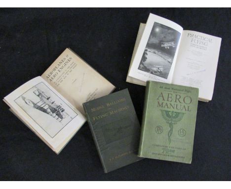
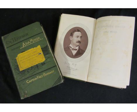
FLIGHT COMMANDER W G MCMINNIES: PRACTICAL FLYING, COMPLETE COURSE OF FLYING INSTRUCTION, illustrated E L Ford, London, Temple Press, 1918 1st edition, frontis + 2 full page plates + folding map + illustrations in text as called for, original cloth, ownership ink stamp of Cecil F W Cudworth to title page, verso map etc + JOHN HENRY ALEXANDER: MODEL BALLOONS AND FLYING MACHINES WITH A SHORT ACCOUNT OF THE PROGRESS OF AVIATION, London, Crosby, Lockwood & Son, 1910, 1st edition, black and white frontis, 5 folding sheets of "working drawings", + black and white illustrations in text as called for, 127pp + 32pp publishers adverts at end, original cloth gilt + THE AERO MANUAL, A MANUAL OF MECHANICALLY PROPELLED HUMAN FLIGHT, COVERING THE HISTORY OF THE WORK OF EARLY INVESTIGATORS, AND OF THE PIONEER WORK OF THE LAST CENTURY..., London, Temple Press Ltd, 1910, 2nd edition, original cloth, "Sheffield Model Aero Club" ink stamps to half title, title etc + "AVION": AEROPLANES AND AERO ENGINES, AN INTRODUCTION TO THE STUDY OF FLIGHT IN SIMPLE LANGUAGE FOR THE MAN IN THE STREET, London, 1918, 1st edition, black and white frontis + 43 black and white illustrations in text as called for, original cloth, ownership ink stamps of Cecil F W Cudworth to top board, title etc (4)

Lot 63

CHRISTOPHER TOLKIEN: PICTURES BY J R R TOLKIEN, London, 1979, 1st edition, original cloth gilt worn, dust-wrapper + BRIAN SIBLEY & JOHN HOWE: THE MAP OF TOLKIEN'S BELERIAND AND THE LANDS TO THE NORTH, London, HarperCollins, 1999 1st impression, folding coloured map, original pictorial wraps + KAREN WYNN FONSTAD: THE ATLAS OF MIDDLE-EARTH, London, Grafton, 1992, 1st UK edition, original pictorial laminated wraps + DAVID DAY: 2 titles: TOLKIEN THE ILLUSTRATED ENCYCLOPAEDIA, London, 1991 1st edition, original cloth gilt, dust-wrapper, A TOLKIEN BESTIARY, New York, Ballantine Books 1979, original cloth, dust-wrapper (5)

Lot 664

CLAUD B TICEHURST: HISTORY OF THE BIRDS OF SUFFOLK, London, 1932, 1st edition, 21 plates plus large folding map as called, original cloth gilt

Lot 686A

R T MCMULLEN: DOWN CHANNEL FROM LONDON TO THE LANDS END IN THE "LEO"..., London, 1869, 1st edition, frontis + 4 maps (of which 2 folding), original blind stamped cloth gilt worn, + SUMMER TOURS IN SCOTLAND, GLASGOW TO THE HIGHLANDS, THE ROYAL ROUTE WITH TIMETABLES AND LIST OF FARES, WITH DAVID MACBRAYNE'S ROYAL MAIL STEAMERS "COLUMBA", "IONA" ETC, 1896, "Official Guide - new edition", original pictorial cloth gilt worn + LT COL F M BAILEY: CHINA - TIBET - ASSAM, A JOURNEY, 1911, 1945 1st edition, original cloth gilt + S M BURROWS: THE BURIED CITIES OF CEYLON; A GUIDEBOOK TO ANURADHAPURA AND POLLONARUA; WITH CHAPTERS ON DAMBULLA, KALAWEWA..., Columbo, A M & J Ferguson, 1885, folding map + folding railway timetable, original half cloth worn and soiled, + R P MURRAY: THE FLORA OF SOMERSET, Taunton, 1896, rebound half calf gilt, top edge gilt + FISHERS DRAWING ROOM SCRAPBOOK WITH POETICAL ILLUSTRATIONS, London, 1833, grey frontis, engraved vignette title + 34 engraved plates as called for, original calf backed blind stamped cloth gilt, all edges gilt, inner joints split (6)

Lot 689

R NISBET BAIN: THE DAUGHTER OF PETER THE GREAT ..., Westminster 1899 1st edition, frontis plus 6 plates as called for, inscribed presentation copy, original cloth gilt worn plus W K KOROSTOWETZ: THE RE-BIRTH OF POLAND, 1928 1st edition, frontis plus 4 maps as called for, original cloth gilt ex German Consulate Glasgow Institutional markings plus THE DOWAGER MARCHIONESS OF DUFFERIN AND AVA: MY RUSSIAN AND TURKISH JOURNALS, London, John Murray 1916 1st edition, frontis plus 11 plates as called for, original cloth gilt worn, ffep, frontis and half title loose plus A F FOORD: SPRINGS, STREAMS AND SPAS OF LONDON HISTORY AND ASSOCIATIONS, 1910 1st edition, original cloth gilt plus JOHN FINNEMORE: PEEPS AT MANY LANDS INDIA, Illustrated Mortimer Menpes, London, A & C Black 1907 1st edition, 12 coloured plates plus map as called for, original cloth worn plus 1 other similar (6)

Lot 694

WALTER R LAWRENCE: THE VALLEY OF KASHMIR, London, Henry Frowde, 1895, 1st edition, 17 black and white plates from photographs + 4 charts + folding coloured map as called for, original cloth backed boards worn, printed paper label to spine (worn)

Lot 695

CAPT FRED BURNABY: ON HORSEBACK THROUGH ASIA-MINOR, London, Samson Lowe, 1877, 1st edition, 2 volumes, 1st edition, mounted Woodbury type portrait photograph frontis + 3 folding maps as called for (of which 2 coloured), map of "routes which traverse Asia-Minor and Mesopotamia" with closed tear, volume 1 - 24pp publishers adverts at end dated September 1877 and errata slip tipped in at end, original pictorial cloth gilt worn, "Mudie's Select Library" labels to top boards (2)

Lot 697

R FRISON-ROCHE AND G TAIRRAZ: SUR LES TRACES DE PREMIER DE CORDEE, Paris and Grenoble, 1952, black and white and colour illustrations from photographs as called for, rebound, half calf gilt + MICHEL FABRIKANT: LES TOPO-GUIDES DE L'ALPINIST ET DU RONDONNEUR EN CORSE II LE MASSIF DU SINTO, Club Alpin Francais et de la Federation Francaise de la Montagne, circa 1960, parts 1-4 in 3 volumes + supplement + folding map (5 volumes), each original printed wraps, original slip-case + G FLEMWELL: CHAMONIX, Blackie, 1913, 1st edition, 12 coloured plates as called for, original boards, pictorial label to top board + ROGER FRISON-ROCHE: 50 ANS EN MONTAGNE, 1974, original cloth, dust-wrapper + EMILE GOS AND LOUIS SEYLAZ: ALPES VAUDOISES, Lausanne, 1948, 1st edition, original cloth, dust-wrapper + G REBUFFAT AND G M OLLIVE: CALANQUES, 1957 reprint, original cloth pictorial label to top board + PATRICK CORDIER: LES PREALPES DU SUD, 1981, original pictorial laminated boards + MASSIF DES ECRINS, folding map circa 1922, (7)

Lot 73

G A HENTY: 2 titles: WITH FREDERICK THE GREAT, A STORY OF THE SEVEN YEARS WAR, London, Blackie & Son, 1898, [1897], 1st edition, 12 black and white plates + 8 black and white maps as called for, 32pp adverts at end, headed "Books for Young People", original pictorial red cloth gilt, bevelled edges, THROUGH THE SIKH WAR; A TALE OF THE CONQUEST OF THE PUNJAUB, London, Blackie & Son, 1894, variant issue, 12 black and white plates + map as called for, original pictorial grey cloth gilt, bevelled edges, all edges olive green + S R CROCKETT: SWEETHEART TRAVELLERS, A CHILD'S BOOK FOR CHILDREN, FOR WOMEN AND FOR MEN, London, Wells, Gardner, Darton & Co, 1895, 2nd edition, black and white frontis, illustrated title page + 12 plates as called for, original pictorial cloth + HAMPDEN GORDON: OUR GIRLS IN WARTIME, illustrated Joyce Dennys, London, John Lane [1917] 1st edition, original cloth backed pictorial boards (4)

Lot 730

W PITT: GENERAL VIEW OF THE AGRICULTURE OF THE COUNTY OF WORCESTER..., 1969, facsimile of the 1st edition published 1813, folding map frontis, original cloth dust-wrapper + MAXWELL FRASER: COMPANION INTO WORCESTERSHIRE, 1949, 4th edition, original cloth + R M HAINES: A CALENDAR OF THE REGISTER OF WOLSAN DE BRANSFORD, BISHOP OF WORCESTER 1339-49, 1966 1st edition, original cloth dust-wrapper + CALENDAR OF WILLS AND ADMINISTRATIONS IN THE CONSISTORY COURT OF THE BISHOP OF WORCESTER 1601-1652, 1968, Kraus reprint, original printed wraps + M PATERSON & ERNIE WARD: ASHTON KEYNES, A VILLAGE WITH NO HISTORY, 1986 1st edition, original cloth dust-wrapper + VICTOR SKIPP: MEDIEVAL YARDLEY, THE ORIGIN AND GROWTH OF A WEST MIDLAND COMMUNITY, 1970, original cloth dust-wrapper + R HUNT & R JACKSON: INKBERROW WAYS, 1982, original printed wraps + ARTHUR MEE: WORCESTERSHIRE, THE GARDEN IN THE HILLS, 1947 reprint, original cloth dust-wrapper (8)

Lot 757

WILLIAM WHITE: HISTORY, GAZETTEER AND DIRECTORY OF SUFFOLK, 1885, 4th edition, large folding map (laid down reinforced and repaired), original cloth, rebacked, original backstrip retained, new end papers

Lot 758

WILLIAM WHITE: HISTORY, GAZETTEER AND DIRECTORY OF SUFFOLK, 1874, 3rd edition, large folding map tipped onto front paste down, original half calf rebacked, new front end paper + H R BARKER (EDITED): WEST SUFFOLK ILLUSTRATED, 1907, half calf gilt, armorial book plate to front paste down (2)

Lot 759

KELLY'S DIRECTORY OF NORFOLK, 1900, 12th edition, large folding coloured map, original cloth gilt worn

Loading...Loading...
  • 108737 item(s)
    /page

Recently Viewed Lots