We found 109182 price guide item(s) matching your search
There are 109182 lots that match your search criteria. Subscribe now to get instant access to the full price guide service.
Click here to subscribe- List
- Grid
-
109182 item(s)/page


Lot 873
An antique, hand coloured engraved map by Georg Braun and Franz Hogenberg of Brightstowe (Bristol), 40x52cm unframed, together with an original purchase receipt from Francis Edwards Ltd of London dated 1969, also together with a collection of further 19th century engravings relating to Bristol including views of Henbury, Blaise Castle, and further Henbury related ephemera


Lot 944
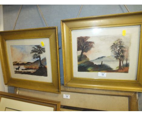
A signed monochrome limited edition screen type print after Peter Brook showing a winter landscape with farm buildings and sheep, signed bottom right, edition number 108/150, with remains of Thomas Agnew and Sons label verso, 57x77cm in wooden frame, together with a late 18th century engraved map of Kent, a 19th century engraving of Thornbury Castle and a 19th century engraving of Bristol from Rownham Ferry


Lot 207
MID 19th CENTURY 'ATLAS OF ANCIENT GEOGRAPHY' by Samuel Butler, Lord Bishop of Lichfield & Coventry, with twenty one two-page maps and four smaller maps on double page, binding as found, together with an ANTIQUE HAND COLOURED MAP OF THE WEST RIDING OF YORKSHIRE, 7" x 4 1/2" (17.8 x 11.5cm) and another of 'Lincolnshire', 3 1/4" x 4 3/4" (8.3 x 12.1cm) (3)


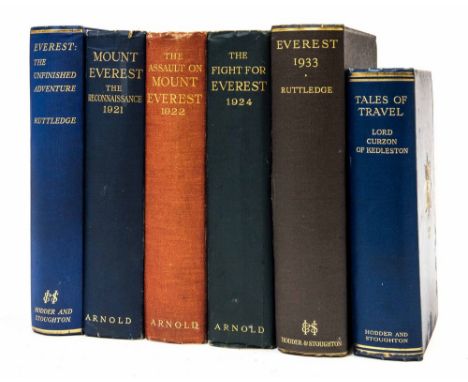
Lot 1189
Travel/Exploration/Everest collection, comprising: 'Mount Everest, The Reconnaissance 1921', C. K. Howard-Bury, first edition, London: Edward Arnold & Co., 1922, photogravure frontispiece, black & white illustrations, three folding maps; 'The Assault on Mount Everest 1922', C. G. Bruce, first edition, London: Edward Arnold & Co., 1923, photogravure frontispiece, black & white illustrations, two folding maps; 'The Fight for Everest: 1924', E. F. Norton, first edition, London: Edward Arnold & Co., 1925, colour and black & white plates, large folding map; 'Everest 1933', Hugh Ruttledge, London: Hodder & Stoughton Limited, 1934; 'Everest: The Unfinished Adventure', Hugh Ruttledge, London: Hodder & Stoughton, 1937; 'Tales of Travel', Marquess Curzon of Kedleston, London: Hodder & Stoughton, 1923. (6)

Lot 1196
'Journal of a Second Expedition into the Interior of Africa, from the Bight of Benin to Soccatoo', by the Late Commander Clapperton of the Royal Navy, London: John Murray, 1829. Large folding map/chart showing Clapperton's route. Quarto half-cloth and marbled boards, untrimmed page edges, armorial bookplate for Warrington Museum, engraved frontispiece portrait. Travel/Exploration/Africa interest.

Lot 1199
'Travels in the Interior Districts of Africa: Performed in the Years 1795, 1796, and 1797, with an Account of a Subsequent Mission to that Country in 1805', by Mungo Park, Surgeon, new edition in two volumes, London: John Murray, 1816-17, complete with large folding map to Vol.II. Octavo leather bindings with gilt decoration, black morocco title labels and gilt lettering, marbled endpapers. Together with two further editions of the work: a fourth edition by Bulmer & Co., 1800, rebound, and an edition from 1799 by J. W. Myers, rebound. Travel/Exploration/Africa interest. (4)

Lot 1201
'Travels in the Timanee, Kooranko, and Soolima Countries, in Western Africa', by Major Alexander Gordon Laing, London: John Murray, 1825. Aquatint plates depicting natives, folding map frontispiece. Octavo cloth with gilt title, pale yellow endpapers, untrimmed page edges. Complete with all plates as called for (seven aquatint plates, one folding map). Travel/Exploration/Africa interest.

Lot 1205
'The Private Journal of Captain G. F. Lyon, of HMS Hecla, During the Recent Voyage of Discovery Under Captain Parry', London: John Murray, 1824. All seven plates as called for, including the frontispiece, plus a folding map / sea chart showing the voyage to discover a North-West Passage. Octavo half-calf and marbled boards, rebacked in calf with oxblood morocco title label, untrimmed page edges, Royal Cruising Club bookplate; from the Working Library of Hammond Innes with his bookplate. Travel/Exploration interest.

Lot 1206
'Ismailia, a Narrative of the Expedition to Central Africa for the Suppression of the Slave Trade', Sir Samuel W. Baker, in two volumes, London: Macmillan and Co., 1874. Numerous wood engraved plates depicting natives, topographical views/landscapes, animals/natural history, and scenes such as slave hunters fighting the "forty thieves". Octavo calf bindings, black title labels, marbled endpapers/all page edges, large folding map. Travel/Exploration/Africa interest.

Lot 1210
'Letters Written During a Ten Years' Residence at the Court of Tripoli', including an account of the domestic manners of the Moors, Arabs, and Turks, third edition in two volumes, London: Henry Colburn, 1819. Illustrated with seven vibrant hand-coloured aquatint plates depicting costumes/culture/customs/landmarks, and a folding engraved map of the 'Regencies of Tripoly and Tunis'. Octavo red leather bindings with olive green morocco title labels and gilt lettering, marbled endpapers/all page edges; armorial bookplate for Syston Park, Ex Libris Sefik E. Atabey. Travel/Exploration interest. (2)

Lot 1211
'New Travels into the Interior Parts of Africa, by the way of the Cape of Good Hope', Le Vaillant, first English edition, in three volumes, London: Printed for G. G. and J. Robinson, 1796. Large engraved folding map showing southern part of Africa, engraved plates (five of which folding) depicting natives, encampments, animals. Octavo calf bindings rebacked at some point incorporating original boards, oxblood and dark green morocco title labels with gilt lettering to spines. Travel/Exploration/Africa/Natural History interest. (3)

Lot 1217
'Egypt, the Soudan and Central Africa', John Petherick, first edition, Edinburgh & London: William Blackwood and Sons, 1861. Octavo calf binding with red & black morocco title labels, gilt lettering/decoration, marbled endpapers and all page edges, armorial bookplate for John Tennant. Folding map at end. Travel/Exploration/Africa interest.

Lot 1222
Joan Blaeu original 17th-century map of Derbyshire, hand-coloured copper engraving on laid/chain-lined paper, featuring decorative cartouche, heraldic shields, putti, figures in contemporary fashion, cattle and sheep. Mounted and framed, ready to display: approx. 50cm x 39cm (mount window); 70cm x 59cm (frame). Together with an antique map of Sussex by Robert Morden, hand-coloured, mounted and framed. (2)


Lot 1225
John Speed, original 17th-century map of Europe. Hand-coloured copper engraving on laid/chain-lined paper bearing manufacturer's watermark. Sold by George Humble. English text to verso. The map features inset views of chief cities and depicts figures in contemporary costume, ships, sea monsters. Framed, glazed to recto and verso. Approx. 51.5cm x 39cm (mount window); 73cm x 57.5cm (frame).

Lot 1228
John Speed 17th-century map of the world, sold by George Humble, English text to verso, hand-coloured copper engraving on laid/chain-lined paper bearing manufacturer's watermark. The map shows allegorical figures representing the four elements; diagrams of 'Heavens and Elements'; illustrations of eclipses and celestial hemispheres; portraits of circumnavigators including Sir Francis Drake; interesting cartographic features such as California being shown as an island; ships and sea monsters. Framed and ready to display. Approx. 56cm x 44cm (including frame). Provenance: Vendor's godfather was a cartographer based in Australia; the frame bears label to verso for Richard Nicholson of Chester (antique map dealer).

Lot 1229
'A General Chart: Exhibiting the Discoveries made by Captn. James Cook in this and his two preceeding Voyages; with the Tracks of the Ships under his Command', by Lieutenant Henry Roberts of His Majesty's Royal Navy. Large and highly detailed copper-engraved map on laid/chain-lined paper bearing manufacturer's watermark (J Whatman), c.1785, centred on Australasia with the routes of the Endeavour and Resolution. Approx. 101.5cm x 66.5cm. Travel/Exploration interest. Provenance: Vendor's godfather was a cartographer and antique map collector based in Australia.

Lot 1230
Collection of antique maps of Australia: includes 'Southern Hemisphere' by John Thomson; 'Australia' by James Wyld; 'Asia' (showing New Holland) by Thomas Bowen c.1779; 'Western Australia' and 'Gold Regions of Australia' (both by James Wyld); selection of interesting lithographs showing plans for townsites in Australia, and others similar, mostly 19th century. Travel/Exploration interest. Provenance: Vendor's godfather was a cartographer and antique map collector based in Australia. (22 in folder).

Lot 1231
17th-century map of the world by Nicolas Sanson, published in Paris: L'Hydrographie ou Description de L'Eau', copper engraving on laid/chain-lined paper, the plate dated 1652. Together with three other world maps, including an 18th-century German example. Provenance: Vendor's godfather was a cartographer and antique map collector based in Australia. (4)

Lot 1232
'A Complete Map of the Southern Continent', the first English map of Australia, by Emanuel Bowen, 'Survey'd by Capt. Abel Tasman & depicted by Order of the East India Company in Holland in the Stadt House at Amsterdam', copper engraving on laid/chain-lined paper bearing manufacturer's watermark (fleur-de-lys), published in London c.1744. Together with 'Chart of Part of the Coast of New South Wales, from Cape Tribulation to Endeavour Straits', by Lieut. J. Cook, 1770'. Provenance: Vendor's godfather was a cartographer and antique map collector based in Australia. (2)
![Books/atlases, comprising: 'Australia', by R. Montgomery Martin [1853], containing eight double page colour maps, plus engrav](https://cdn.globalauctionplatform.com/bf825d2c-a2f7-4b2c-9aa1-a84300b6aaa1/3fd6bf6f-8276-49f5-8e3e-a83603c70e87/468x382.jpg)
Lot 1233
Books/atlases, comprising: 'Australia', by R. Montgomery Martin [1853], containing eight double page colour maps, plus engraved portraits, quarto publisher's cloth & gilt; 'Nelson's Junior Atlas', London: Thomas Nelson and Sons, 1862; 'Britannia', John Ogilby, facsimile of the original 1675 edition. Travel/Exploration/Maps/Australia interest. Provenance: Vendor's godfather was a cartographer and antique map collector based in Australia. (3)

Lot 1234
Collection of antique maps housed in protective folder, featuring Australia and New Zealand; to include Thomas Kitchin's 'General Map of Indostan or the Great Mogol's Empire', and Saxton's map of 'West Riding'; also two vellum indentures. Provenance: Vendor's godfather was a cartographer and antique map collector based in Australia. (15)
-
109182 item(s)/page