We found 109182 price guide item(s) matching your search
There are 109182 lots that match your search criteria. Subscribe now to get instant access to the full price guide service.
Click here to subscribe- List
- Grid
-
109182 item(s)/page


Lot 440
A box of various pictures to include a print of a lion; humorous coloured print depicting Prince Charles, signed Bob; an oil on canvas depicting country house; a map of Suffolk; Indian school painting on leaf; a humorous framed text; a watercolour entitled "From St Mary's Church"; and three other pictures


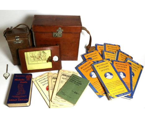
Lot 1
An Early 20th Century Leather Travelling Map Case, by the Michelin Company, having an embossed Michelin logo to the lid and stamped Michelin Maps and Guides, with divided interior, including: Maps of Great Britain, numbered 5, 6, 8, 9, 10, 11, 12, 13, 14 and 15 Two associated maps, numbered 9 and 13, Wigtown to Douglas and Macclesfield to King's Lynn Aa further map of The British Isles Manchester to York, number 11 A 1923 Michelin Guide to Great Britain, hardback Bacon's Road Atlas of England and Wales, price 1/6, paperback Two Early 20th Century Leather Travelling Map Cases, one containing Bartholomew's New Reduced Survey, sheet 5 Hawick and Borders, sheet 2 Dumfries and Solway Three volumes including The AA 1911 Handbook, a leather bound book Contour England, issued by Gall & Inglis, and a blue leather bound The Contour Road Book of Scotland, the smaller case containing three folding maps and the Bartholomew's New Reduced Survey Sheet 26 of Essex


Lot 72
John Hutchison R.S.A. (Scottish 1833-1910), marble bust of Sir James Falshaw, Lord Provost of Edinburgh (1874 - 1877), titled SIR JAMES FALSHAW BART, signed and dated 1876, on a red marble square pedestal having a rotating mechanism to the top, the bust 64cms h (182cms h with pedestal). The bust is offered with two volumes of associated interest:- The Life of Sir James Falshaw Bt. by his nephew George Andrew Hobson, Caradoc Press 1905, limited edition 96/100 and Airey's Railway Map of Scotland by John Airey 1884, )Note: Sir James Falshaw, Bt (1810-1889) was a renowned 19th Century railway engineer. Born in Leeds, he spent the early years of his working life in England, before moving to Stirling to manage the construction of the Caledonian Railway. His first wife died in 1864 and having remarried in 1871 he and his new wife moved to Edinburgh. Sir James was Lord Provost of Edinburgh between 1874 and 1877 and is believed by the consignor to have the unique distinction of being the only Englishman to have attained the position of Lord Provost of the City. Provenance; The bust has been consigned by a descendant of Sir James Falshaw


Lot 3140
Lincolnshire cloth scroll maps, comprising Plan of the Old Inclosure of Salt Marsh of the Parish of Kirton by I Hill & Son 1839, a map showing the division of pockets of land at Kirton Fen, late 19thC, further maps of the Inclosure of Kirton Marsh, A & B 1873, signed by the Inclosure Commissioners G Ridley and James Caird, with a legal document on vellum detailing the allotments of land, fifteen sheets, signed under seal, (3).
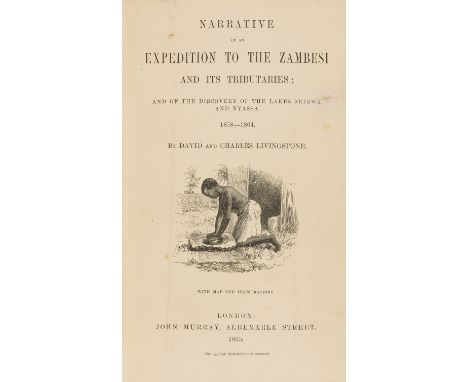
Lot 1
Africa.- Livingstone (David and Charles) Narrative of an Expedition to the Zambesi and its Tributaries, first edition, folding frontispiece, 12 plates and folding map, small tear on title repaired, slightly browned, ink inscription on fly-leaf, endpapers foxed, bound in near contemporary calf, gilt, partially faded and marked, gilt panelled spine, green gilt morocco label on spine, by S. Hogg, 8vo, John Murray, 1865.


Lot 11
Europe.- Sainte-Maure (Charles de) A New Journey through Greece, Aegypt, Palestine, Italy, Swisserland, Alsatia, and the Netherlands...by a French Officer..., second edition, contemporary mottled calf, spine ends chipped, lacking label, for J.Batley and J.Wood, 1735 § [Macky (John)] A Journey Through the Austrian Netherlands, second edition, half-title, contemporary ink signature "Edw. Weld" on title and with engraved bookplate of Thomas Weld of Lulworth Castle, contemporary panelled calf, splits to joints, lacking label, for J.Pemberton, 1732 § Allom (Thomas) Views in the Tyrol, engraved vignette title, 45 plates after Allom and folding map, tissue guards, water-staining to foot of title, some foxing, contemporary green roan, g.e., spine nicked at head, [1840], rubbed; and another, 8vo (4)

Lot 15
Levant.- Dumont (Jean) A New Voyage to the Levant: containing an Account of the most Remarkable Curiosities in Germany, France, Italy, Malta, and Turkey, fourth edition, engraved frontispiece and 8 folding plates, a little browned, water-staining to lower inner margin, contemporary ink inscription to front free endpaper, contemporary panelled calf, rubbed rebacked, for T.Goodwin, M.Wotton, and B.Tooke [& others], 1705 § Craven (Elizabeth, Lady) A Journey through the Crimea to Constantinople, second edition, lacking half-title, with folding engraved map and 6 plates, one double-page, spotting and soiling, map defective at head (laid down), modern half calf, 1789; and 2 others, Levant, 8vo & 4to (4)
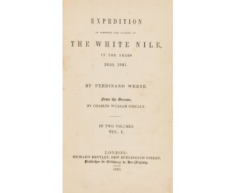
Lot 2
Africa.- Werne (Ferdinand) Expedition to Discover the Source of the White Nile in the Years 1840, 1841, translated by C.W.O'Reilly, 2 vol. in 1, first English edition, folding lithographed map but lacking plate, also lacking half-titles and advertisement leaf, browned, some spotting, map spotted and with short tear to fold, contemporary calf prize binding, gilt, spine gilt, rubbed, upper joint repaired, 12mo, 1849.⁂ Account of the second European exploration to locate the source of the White Nile, which laid the foundations for the later journeys of Burton, Speke and Baker.

Lot 21
Spain.- Janssonius (Johannes) Novissima Arragoniae Regni Tabula, Spanish province of Aragon, engraved map with outline hand-colouring, 450 x 550 mm. (17 3/4 x 21 3/4 in), blank verso, central vertical fold with minor repaired splitting, small loss in upper left margin, minor browning, Amsterdam, [circa 1630]; Navarra, engraving with hand-colouring, 390 x 490 mm. (15 1/2 x 19 1/4 in), blank verso, central vertical fold, with repaired splitting, minor surface dirt and light browning, [circa 1630] § Blaeu (Joan) Utriusque Castellae nova descriptio, map of the historic Kingdom of Castile, engraving with outline hand-colouring, 415 x 500 mm. (16 1/4 x 19 3/4 in), blank verso, central vertical fold with repaired splitting, handling creases, minor surface dirt and browning, [circa 1630]; and Valentia Regnum, engraved map centred on Valencia, 360 x 480 mm. (14 1/4 x 18 7/8 in), central vertical fold, with some repaired splitting, light spotting and browning, surface dirt, [circa 1635] (4).

Lot 26
World.- Willis (Nathaniel Parker) American Scenery; or, Land, Lake and River Illustrations of Transatlantic Nature, engraved additional titles, map and 118 engraved plates, after W.H. Bartlett, tissue guards, some foxing and browning, some extra engravings tipped-in on lower endpapers, contemporary half calf, gilt, rubbed, covers slightly faded, g.e., George Virtue, 1840; and 8 others, including: The Danube, France Illustrated, The Bosphorus etc., 4to (10).

Lot 4
America.- Melish (John) Travels through the United States of America, in the Years 1806 & 1807, and 1809, 1810, & 1811, folding engraved hand-coloured map frontispiece, 5 maps (1 folding and hand-coloured), 2 engraved plates, 2 folding tables, occasional spotting, bookplate, contemporary half calf, a little rubbed, 8vo, Philadelphia, 1818.
Lot 6
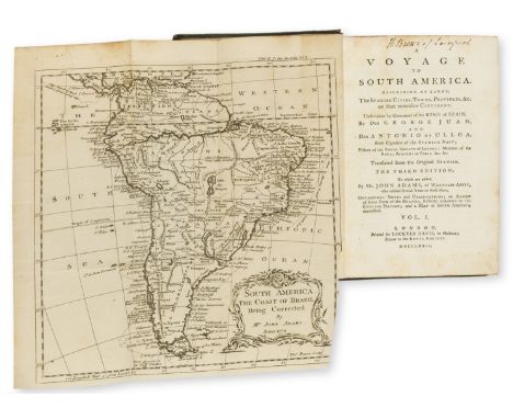
Americas.- Ulloa (Antonio de) A Voyage to South America..., translated by John Adams, 2 vol., third English edition, folding engraved map, 6 folding engraved plates and plans, contemporary ink inscription at head of titles, occasional spotting, later half green roan, gilt, a little rubbed and marked, for Lockyer Davis, 1772 § Charlevoix (P.-F.-X. de) The History of Paraguay, 2 vol., first English edition, light browning or water-staining, worming to vol.2, contemporary calf, spines gilt, rubbed and stained, worming, spines repaired, 1769, [Sabin 36813 & 12133], 8vo (4)

Lot 8
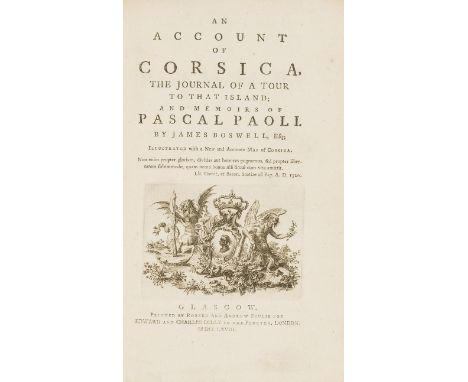
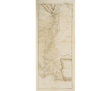
Corsica.- Boswell (James) An Account of Corsica, the Journal of a Tour to that Island ..., first edition, half-title, engraved vignette title, folding engraved map by Thomas Phinn in second state (tear, repaired), D2 in first state with "John Home" affixed to first quotation, E2 in second state with "enjoying the noble fief of Is-tria", Z3 in second state with "Mariani" corrected, occasional spotting, near contemporary ex-library ink annotations to blank prelims, occasional faint off-setting, early nineteenth century calf, rebacked, a little rubbed, and worn, [Rothschild 442-445], 8vo, Glasgow, Robert and Andrew Foulis, 1768.
Lot 9
Egypt.- Wilson (Robert Thomas) History of the British Expedition to Egypt, second edition, lacking half-title, with engraved portrait and 3 folding maps/battle plans with partial hand-colouring, 2 folding letterpress tables, some light spotting and offsetting, contemporary half calf, spine gilt, upper joint split, spine worn at head, 1803 § Sonnini (C.S.) Travels in Upper and Lower Egypt..., second edition in English, half-title, engraved portrait, folding map and 27 plates, errata/advertisement leaf at end, spotting, browning to text, map spotted and torn (rather crudely repaired causing staining), contemporary half calf, rubbed, 1800, 4to (2)

Lot 389
Players 1938 and 1934 cricketers cards, garden hints and poultry, Churchman :egends of Britain, a quantity of mixed Brooke Bond card, Fifteen Topical Times football pictures, Bacons cycling and motoring map of England and Wales, Various albums played and 1920's panto album etc We cannot do condition reports for this sale.
Lot 10
STANSBURY, HOWARD - AN EXPEDITION TO THE VALLEY OF THE GREAT SALT LAKE OF UTAH Including a description of its Geography, Natural History, and Minerals, and an analysis of its Waters: with an Account of the Mormon Settlement.....also, a Reconnoissance of a New Route through the Rocky Mountains, and two Large and Accurate Maps of that Region. Philadelphia, Lippincott, Grambo & Co, 1855. First edition, 8vo, lithographed and tinted plates (several folding), all plates present and correct, lacking the (lesser) La Hontan map of "The Long River" - but - this copy has the two large rare additional folding maps (in a separate volume as published) of the route through the Rocky Mountains showing Indian territories, forts, etc. Publisher's cloth, gilt faded. A fascinating and beautifully illustrated book, the large folding maps now missing from most copies (2) ++Lacking the (lesser) La Hontan map of "The Long River" - but - this copy has the two large rare additional folding maps (in a separate volume as published) of the route through the Rocky Mountains showing Indian territories, forts, etc. Publisher's cloth rubbed and gilt faded, slight wear to extremities, internal occasional foxing and toning
![[NOTTINGHAMSHIRE INTEREST] BAILEY, THOMAS - ANNALS OF NOTTINGHAMSHIRE HISTORY OF THE COUNTY OF NOTTINGHAM Including the Borou](https://cdn.globalauctionplatform.com/ef9e6eaa-7d8b-4f64-8216-a8ce011940aa/afcc3d4b-c274-482f-c5e1-1def9c432e5b/468x382.jpg)
Lot 126
[NOTTINGHAMSHIRE INTEREST] BAILEY, THOMAS - ANNALS OF NOTTINGHAMSHIRE HISTORY OF THE COUNTY OF NOTTINGHAM Including the Borough. London, Simpkin, Marshall, and Co, [1853]. First edition, four volumes bound in two (complete), large 8vo, titles to vols 1 & 2 bound at beginning of each book, other titles discarded, folding map present, later half brown morocco leather, good; plus a rare printed 'PROGRAMME OF THE CELEBRATION OF THE QUEEN'S DIAMOND JUBILEE' for Nottingham in 1897, being the copy of Richard FitzHugh J.P. who was a member of the Jubilee Celebration Committee, in original leather binding; and another 'OFFICIAL RECORD OF THE CELEBRATION OF THE DIAMOND JUBILEE...', 1897, a presentation copy from the Town Clerk, Sir Samuel Johnson, original cloth binding (4)
![[NOTTINGHAMSHIRE INTEREST] BROWN, CORNELIUS - LIVES OF NOTTINGHAMSHIRE WORTHIES and of Celebrated and Remarkable Men of the C](https://cdn.globalauctionplatform.com/ef9e6eaa-7d8b-4f64-8216-a8ce011940aa/b38b4f9b-1503-4a2a-c93b-729aaf4c478c/468x382.jpg)
Lot 127
[NOTTINGHAMSHIRE INTEREST] BROWN, CORNELIUS - LIVES OF NOTTINGHAMSHIRE WORTHIES and of Celebrated and Remarkable Men of the County, from the Norman Conquest to A. D. 1882. London, H Sotheran, 1882. First edition, 4to, Woodburytype photograph frontispiece of Philip James Bailey, other Woodburytype plates, good in the original green cloth; RODGERS, JOSEPH - THE SCENERY OF SHERWOOD FOREST with an Account of Some Emininent People Once Resident There. London, Fisher Unwin, 1908. First edition, 4to, illustrations, publisher's green cloth; HAMMOND, T W - NOTTINGHAM PAST AND PRESENT Fifty Reproductions of Crayon Drawings. Nottingham, J & H Bell, 1926. First edition, 4to, tipped-in colour and other plates, folding map of Nottingham (not called for) bound in at the rear, good in original buckram with gilt lettering (3)
Lot 128
A GOOD COLLECTION OF BOOKS ON NOTTINGHAM AND NOTTINGHAMSHIRE including WHYTE, F & J - HISTORY, DIRECTORY, AND GAZETTEER... OF NOTTINGHAM Sheffield, 1844. Map not present, as usual. Calf, re-backed retaining original spine; HICKLIN, JOHN - THE HISTORY OF NOTTINGHAM CASTLE from the Danish Invasion to the Destruction by Rioters, in 1831. London, Hamilton, 1836. First edition, 8vo, additional engraved title, 5 engraved plates, folding plan and facsimile (as called for), green cloth; BAWDEN, REVD WILLIAM - A TRANSLATION OF THE RECORD CALLED DOMESDAY So Far as it Relates to the County of York. Also the Counties of Derby, Nottingham, Rutland, and Lincoln. Doncaster, W Sheardown, 1809. First edition, 4to, cloth with leather spine (spine detaching and very worn), advertisement at the rear for planned further volumes at 2 guineas each; and 30 others, various authors and dates, all Notts related (33)
-
109182 item(s)/page