We found 109182 price guide item(s) matching your search
There are 109182 lots that match your search criteria. Subscribe now to get instant access to the full price guide service.
Click here to subscribe- List
- Grid
-
109182 item(s)/page


Lot 1056
The North-east prospect of the City of Norwich, monochrome engraving, 30x77cm, the South-west prospect of Ipswich, in the county of Suffolk, monochrome engraving x2, monochrome engraved town plan of Colchester by Thomas Sparrow 53x72cm, and one other map of Ipswich (5) Condition Report / Extra Information Trimmed. Yellowed and with some foxing.Some minor losses to outer edges.


Lot 323
Thomas Bowen, Engravings with hand colouring, Maps of Europe, Africa, Asia, North America and South America, 33.5cm x 40.5cm Framed and glazed CONDITION REPORT: All with later hand colouring and all mounted closely so that it is not possible to see the edge of the engraved section of the map. Age indeterminable. North America with some crease lines and foxing. South America with a small tear by cartouche and another to the bottom coming from the central fold line. Asia foxed. Africa with browning. (as found)


Lot 497
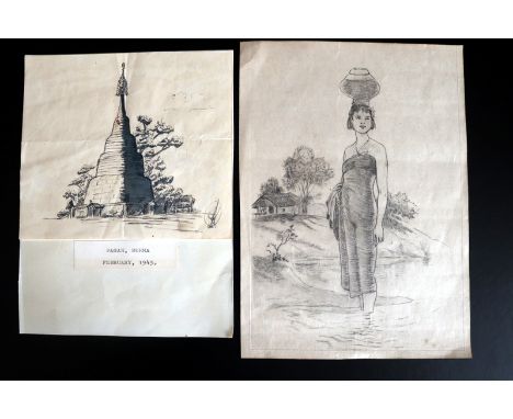
Military Interest, Burmese Campaign 1945, Pen Ink Drawing Of A Temple, Titled Pagan-Burma, Feb 1945, With Burmese Script Monogrammed, Drawn On A Military Field Map Of The Period Showing Air Drop Zones By The 4th Army Corps Over The River Chindwin Together With A Pencil Drawing Of A Burmese Girl Carrying Water In A River Setting, Interestingly Drawn On The Back Of A Japanese Field Map.
![Ptolemy, Claudius (c. 100-170 AD) The Compost of Ptolomeus, Prince of Astronomie. London: Printed by M. P[arsons] for Henry G](https://cdn.globalauctionplatform.com/e154d3cb-0cea-4b63-a8dc-a9130111b048/622c2146-9b12-40e7-ddf1-719d9a0f0f3f/468x382.jpg)
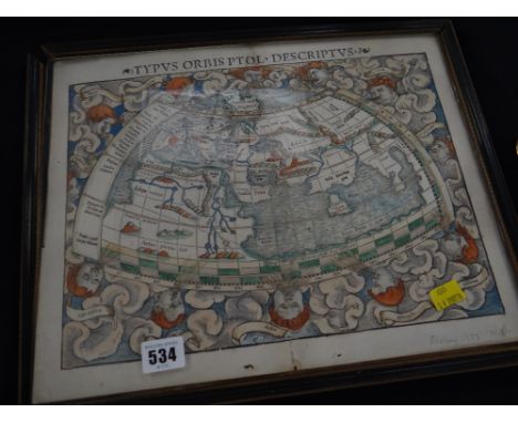
Lot 146
Ptolemy, Claudius (c. 100-170 AD) The Compost of Ptolomeus, Prince of Astronomie. London: Printed by M. P[arsons] for Henry Gosson, and are to be sold by Edward Wright, 1638?. Octavo, woodcut on title, numerous small woodcuts to text, including astrological signs, a very small world map, some physiognomy cuts, and some of chiromancy; rare; no U.S. copies in ESTC; no auction records, bound in later full tan calf, 5 1/2 x 3 1/8 in. A-I8. http://estc.bl.uk/S112005 Estimate $3,000-5,000 The absence of a condition statement does not imply that the lot is in perfect condition or completely free from wear and tear, imperfections or the effects of aging. Condition requests can be obtained via email (lot inquiry button) or by telephone to the appropriate gallery location (Boston/617.350.5400 or Marlborough/508.970.3000). Any condition statement given, as a courtesy to a client, is only an opinion and should not be treated as a statement of fact. Skinner Inc. shall have no responsibility for any error or omission.
Lot 158
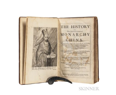
Semedo, Alvarez (1585-1658) History of the Great and Renowned Monarchy of China. London: Printed by E. Tyler for Iohn Crook, and are to be sold at his shop at the sign of the Ship in S. Pauls Church-yard, 1655. First edition in English, folio, illustrated with portrait frontispiece of the author and one full-page engraving; separate title for Martin Martinius's Bellum Tartaricum,with portrait frontispiece; full-page engraved map on Kk3 verso titled, Situs Provinciarum Imperii Sinici, dated 1654; lacking the folding map; bound in full contemporary calf, later endleaves, ex libris Lord Walpole of Woolterton, with his engraved bookplate, binding worn, joints tender, a few scattered water stains, 11 1/8 x 7 in. A4, (A)1, B-Z4, Aa-Qq4, Rr3 (lacking final ?blank Rr4). http://estc.bl.uk/R22006 Estimate $3,000-5,000 The absence of a condition statement does not imply that the lot is in perfect condition or completely free from wear and tear, imperfections or the effects of aging. Condition requests can be obtained via email (lot inquiry button) or by telephone to the appropriate gallery location (Boston/617.350.5400 or Marlborough/508.970.3000). Any condition statement given, as a courtesy to a client, is only an opinion and should not be treated as a statement of fact. Skinner Inc. shall have no responsibility for any error or omission.
Lot 166
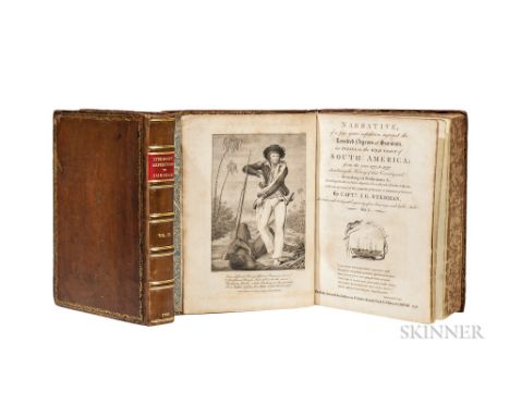
Stedman, John Gabriel (1744-1797) Narrative of a Five Years Expedition against the Revolted Negroes of Surinam. London: for J. Johnson, 1796. First edition, two large quarto volumes, engraved frontispiece in volume one; titles to both volumes engraved; small paper edition, volume one illustrated with two folding engraved maps, one folding plate, and thirty-seven full-page engraved plates (thirteen plates by William Blake); volume two illustrated with thirty-four full-page engravings and one folding map, contents good, the two volumes bound in uniform brown calf, rebacked, 10 3/4 x 8 1/4 in. (2) Stedman was a Dutch soldier deployed to put down an uprising of enslaved people on the island of Suriname. His illustrated text became an important document in the abolitionist movement. I: [pi]2 (frontis & title, a3, b4, c2, B4, C6, D4, E4, *E3, F-Z4, Aa-Mm4, Nn4, *Nn1, Oo-Zz4, 3A-3G4. II: [pi]1, b2, B-Z4, Aa-Zz4, 3A-3E4, 3F2, 3G4. http://estc.bl.uk/T146566 Estimate $3,000-4,000 The absence of a condition statement does not imply that the lot is in perfect condition or completely free from wear and tear, imperfections or the effects of aging. Condition requests can be obtained via email (lot inquiry button) or by telephone to the appropriate gallery location (Boston/617.350.5400 or Marlborough/508.970.3000). Any condition statement given, as a courtesy to a client, is only an opinion and should not be treated as a statement of fact. Skinner Inc. shall have no responsibility for any error or omission.
Lot 185
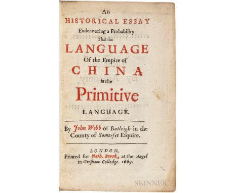
Webb, John (1611-1672) An Historical Essay Endeavoring a Probability that the Language of the Empire of China is the Primitive Language. London: Printed for Nath. Brook, at the Angel in Gresham Colledge, 1669. First edition, octavo, title page printed in red and black, illustrated with folding engraved map of China, bound in modern half leather with marbled paper boards, 6 3/4 x 4 in. In this fascinating work, Webb argues that the Chinese people speak the original language spoken by Adam and Eve in the Garden of Eden. His work is also valuable for its insight into the cross-cultural connections between the English-speaking world and the far east in the mid-17th century. A4, B-O8, P3, (lacking final blank, P4). http://estc.bl.uk/R24606 Estimate $7,000-10,000 The absence of a condition statement does not imply that the lot is in perfect condition or completely free from wear and tear, imperfections or the effects of aging. Condition requests can be obtained via email (lot inquiry button) or by telephone to the appropriate gallery location (Boston/617.350.5400 or Marlborough/508.970.3000). Any condition statement given, as a courtesy to a client, is only an opinion and should not be treated as a statement of fact. Skinner Inc. shall have no responsibility for any error or omission.


Lot 101
China.- Fitch (Robert F.) Hangchow - Chekiang Itineraries, plates, folding maps, folding map in pocket at read, original cloth-backed pictorial boards, Shanghai, 1935; Pootoo Itineraries, plates and plans, some folding, ink ownership inscription, original cloth-backed boards, rubbed, Shanghai, 1929; and another, similar, 8vo (3)
Lot 108
New Zealand.- Barraud (Charles Decimus) and W.T.L.Travers. New Zealand: Graphic and Descriptive, first edition, additional lithographed decorative title with mounted oval chromolithographed vignette, list of subscribers, map, 24 mounted chromolithographed plates after Barraud, 6 plates of tinted lithographs, wood-engraved illustrations, occasional marginal spotting or staining, inner margin of final plate torn and repaired, text with light offsetting from plates and a few marginal chips or tears, dedication becoming loose, original half morocco over pictorial gilt cloth, rubbed, folio, 1877.⁂ Including scenes of Wellington, Auckland, Tarawera Lake, the geothermal terraces of Rotomahana, and Mount Cook.

Lot 110
Southern Africa.- Tirion (Isaac) Nieuwe Kaart van de Kaap der Goede Hoope, map of South Africa showing from St Helena Bay to the Cape of Good Hope, engraving with hand-colouring, 325 x 230 mm. (12 3/4 x 9 in), central vertical fold, some spotting and browning, unframed, Amsterdam, 1763 § Bonne (Rigobert) La Basse Guinee Contenant les Royaumes de Loango, de Congo, d'Angola et de Benguela, engraving with outline hand-colouring, 400 x 250 mm. (15 3/4 x 9 7/8 in), spotting, surface dirt, unframed, [circa 1776]; and John Barrow's Charte von der Halbinsel des Vorgebirgs der Guten Hoffnung nach den Zeichnungen der Holland, Bonne's Carte du Canal de Mozambique, Contenant L'Isle de Madagascar, avec les Cotes de Afrique, and Moll's The Bay of Agoa de Saldanha, engravings, various sizes, all unframed, [17th and 18th centuries]; and with two views after Thomas William Bowler, Port Elizabeth; Graham's Town, from The Bay Road, tinted lithographs, each sheet approx. 275 x 370 mm. (10 7/8 x 14 1/2 in), some spotting and surface dirt, unframed [circa 1860s]; together with four other works relating to South Africa, all unframed, [19th century] (10).

Lot 111
South East Asia.- Bock (Carl) The Head-Hunters of Borneo: A Narrative of Travel Up the Mahakkam and Down the Barito; also, Journeyings in Sumatra, second edition, 30 plates, folding map, illustrations, original pictorial cloth, gilt, neatly recased, extremities a little bumped, 1882; and a copy of Charles Hose, Natural Man: A Record from Borneo, large 8vo (2)

Lot 121
Ireland.- Carr (John) The Stranger in Ireland; or, A Tour in the Southern and Western Parts of that Country in 1805, folding aquatint frontispiece, 15 aquatint plates (4 folding) and a folding engraved map, 2pp, advertisements at end, slightly browned, inner hinges strengthened, contemporary half calf, gilt spine, new morocco label, [Abbey Scenery, 455], 4to, for Richard Phillips, 1806.

Lot 123
Ireland.- The Gentleman's and Citizen's Almanack, Samuel Watson and others, Dublin, 1793, bound with Wilson's Dublin Directory..., folding map at end, ink library stamps on title and verso of last f., slightly browned, Robert Emmett's (physician) copy with his ink signature on front pastedown, contemporary calf, slightly marked, joints splitting, label on spine, rubbed; and another (2).

Lot 125
Ireland.- Guides.- Godkin (James) and John A. Walker. The New Hand-Book of Ireland..., 13 chromolithographed plates and a folding lithographed map, advertisements at end, some soiling and browning, new endpapers, modern cloth, gilt spine, Dublin, [1871]; and a quantity of others, Ireland and Irish Guides, v.s., v.d. (qty).
Lot 130
London.- Ireland (Samuel) Picturesque Views on the River Thames, 2 vol., first edition, half-titles, additional sepia aquatint titles and 52 plates, 2 maps, occasional off-setting, signatures to title heads (obscured with paper labels), ink inscription to blank prelim (vol. 2), short marginal tear (vol. 1), bookplate, contemporary mottled calf, old rebacking in blue morocco with red labels, gilt, a little rubbed and worn, [Abbey, Scenery 430], 1792 § Pennant (Thomas) Some Account of London, folding engraved map, 13 only (of 14) plates, 2 folding, occasional off-setting and marginal finger-soiling, contemporary diced calf, rebacked, a little rubbed and soiled, 1805; and another, London, 8vo & 4to (4)

Lot 47
Naval.- Arrianus (Flavius) Ars Tactica, Acies Contra Alanos Periplus ..., additional engraved title, folding engraved map, folding engraved title, illustrations, modern calf, Amstelodami, Janssonio-Waespergios, 1683 § Bree (John) The Cursory Sketch of the State of the Naval, Military and Civil Establishment ..., vol. 1 only (no others published), half-title, occasional faint spotting, occasional marginal damp-staining, contemporary paper backed boards, rebacked, a little rubbed, 1791; and 3 others, naval, 8vo & 4to (5)

Lot 65
Evelyn (John) Memoirs, Illustrative of the Life and Writings of John Evelyn, edited by William Bray, 2 vol., engraved frontispieces, 8 plates (1 double-page), double-page table, one engraved double-page map, occasional spotting, bookseller's catalogue cutting tipped-in, contemporary calf, rebacked, rubbed and worn, 1819 § Braybrook (Richard, Lord) Memoirs of Samuel Pepys ... Secretary to the Admiralty in the Reigns of Charles II. and James II, 2 vol., engraved frontispieces, 7 engraved plates, 2 tables, facsimile, one folding engraved map, illustrations, spotting and off-setting, bookplates, bookseller's catalogue cuttings tipped-in, contemporary calf, vol. 1 rebacked with original spine laid down, gilt, rubbed and scuffed, 1825 § Walpole (Horace) Private Correspondence of Horace Walpole, 4 vol., engraved frontispiece, occasional faint spotting, bookplates, contemporary half calf, rubbed, 1820; and 16 others, similar, 4to & 8vo (24)


Lot 82
Leidy (Joseph) The Ancient Fauna of Nebraska, inscribed and signed by author, map frontispiece, 24 lithographed plates (1 folding), illustrations, [Washington, Smithsonian Institute, 1853] bound before A Memoir on the Extinct Sloth Tribe of North America, 16 lithographed plates, [Washington, Smithsonian Institute, ?1854], browned, occasional foxing, off-setting, worm damage, original cloth backed boards, ink inscription to upper cover, rubbed, 4to

Lot 390
J. Blaeu 'Comitatus Salopiensis Anglice Shropshire', an antique county map of Shropshire, inscribed within an elaborately engraved cartouche, also inscribed on a later label verso, hand coloured map, 14.5" x 19.25"; together with two further maps depicting North Africa and South Africa and a further map of Palestine, various sizes (3)


Lot 3031
Sea chart / map of Ireland, 'Achill Head to Slyne Head', featuring a table of tidal information, originally published at the Admiralty, 19th December 1855, under the Superintendence of Captain Washington, this edition including corrections up to 1934. Hand-coloured, mounted & framed, 63cm x 51cm (mount window).
Lot 3092
Morden, Robert (c.1650-1703). Collection of three antique maps: two examples of 'Britannia Saxonica' (variations in colouring), and England & Wales. Together with a Herman Moll map of England & Wales. Hand-coloured copper engravings on laid/chain-lined paper, the Saxonica bearing manufacturer's watermark of horse in circle, unmounted/unframed with the exception of one of the Saxonica maps (which is mounted in printseller's cellophane); some wear. (4)
Lot 3503
A gold beaded decorated crescent shaped evening bag 1930s and a white and silver beaded bag with ring handles, a 1977 Silver Jubilee scarf - a blue and gold Goalstream Guards pattern, fine crepe scarf and a smaller silk England 1970 scarf with two crossed St Georges flags - a collection of silk handkerchiefs to include momento of Canterbury, a map of Scotland, a Scottish piper and two floral others (as new) (1930s/40s) (11)

Lot 4082
'The Complete Fisher' or 'True Art of Angling', lacking title page so no publisher details, and lacking opening 26 pages and others, occasional woodcut illustrations of fish, probably late-17th century to early-18th century but could be later, a/f, together with a John Cary map of Derbyshire, 1818, linen-backed in slipcase. (2)


Lot 3599
Samuel Buck (1696-1779) and Nathaniel Buck (fl. 1724-1759), by and after, The East Prospect of Derby, 18th century strike, copperplate engraving with hand-colouring, 30cm x 80cm; English School (18th century), map, Derbyshire, Engrav'd for the Universal Magazine, Printed for T Hinton at the Kings Arms, St. Paul's Church Yard, London 1748, hand-coloured engraving, 22.5cm x 17cm; etc, [3]
![Speed (John), Huntington both Shire and Shire Town with the Ancient Citie of Ely Described, pub. George Humbell, [1616], hand](https://cdn.globalauctionplatform.com/fdf73c92-6ef6-49ab-9886-a90e00d34c85/326bc9af-2b0d-4117-9793-8945d82386e0/468x382.jpg)
Lot 3627
A New and correct Map of Leicester & Rutland, Engrav'd from an actual Survey, with other Improvements, Published by J. Harrison [...], London 1787, two-page, copperplate engraving, 42cm x 51cm; John Lodge Cowley (1719 - 1797), An Improved Map of Flint Shire (sic, Flintshire, Wales), containing the Boroughs and Market Towns with those adjoining; also its Principal Roads and Rovers, [probably printed by R. Dodlsey, at Tully's Head, Pall Mall, London c. 1740], engraving with hand-colouring, 16cm x 14cm, Liz Porter labels to recto and verso, [2]


![Joan Blaeu (1596 - 1673), by and after, two-fold map, Lewis and Harray (sic, [Harris, Outer Hebrides], from the Atlas of Scot](https://cdn.globalauctionplatform.com/fdf73c92-6ef6-49ab-9886-a90e00d34c85/da521af4-044c-44c2-c606-71aa24d6d23c/468x382.jpg)

Lot 3631
Jodocus Hondius (1563 - 1612) after John Speed (1552 - 1629), two-page map, The Countie (sic) of Nottingham, defscribed (sic) the Shire Townes (sics), Situation and the Earls there of obferved (sic), city plan and coats of arms to margins, the whole within a dogtooth border, copperplate engraving with hand-colouring, text to verso pages 65 - 66, [probably London 1676], 40cm x 53cm, Arnolds of Loughborough label to verso

![Robert Morden (c. 1650 - 1703), by and after, a two-page map, Herefordshire, [London c. 1753], hand-coloured engraving, 36.5c](https://cdn.globalauctionplatform.com/fdf73c92-6ef6-49ab-9886-a90e00d34c85/79ef592b-55b6-4440-a782-6524b81826e6/468x382.jpg)

Lot 3677
British Travel and Topography - Hakewill (James), The History of Windsor; and Its Neighbourhood, Edmund Lloyd, London 1813, full-page engraved plates, contemporary quarter-calf and marbled boards (boards loose and spine heavily rubbed), small folio; Seyer (The Revd. Samuel), Memoirs Historical and Topographical of Bristol and It's (sic) Neighbourhood, From the Earliest Period Down to the Present Time, Printed for the Author by John Matthew Gutch, Bristol 1821 - 1823, two-volume set, full-page architectural, topographical and antiquarian engravings, slightly later 19th century quarter-calf and marbled boards, large 4to; Walpoole (George Augustus), The New Britifh (sic) Traveller; Or, A Complete Modern Univerfal (sic) Difplay (sic) of Great-Britian and Ireland, Alexander Hogg, London 1784, lacks title-page, engraved allegorical frontispiece, fold-out map, full-page plates and some vignettes, contemporary calf spine (repaired), papered boards, 18th century and later MS ownership inscriptions, crown folio; Association Copy, The Harbours of England, Engraved by Thomas Lupton, from Original Drawings Made Expressly for the Work by J.M.W. Turner R.A., with Illustrative Text by J[ohn] Ruskin, E. Gambart and Co., London 1856, full-page steel engravings, blue buckram as issued (disbound), dedication inscription in MS ink to endpaper: From the Author's Father [...] With Kindest regards 30 Decr. 1857, crown folio, [5]
-
109182 item(s)/page