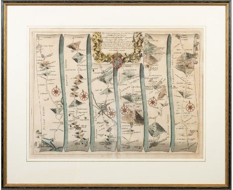
War Maps: Cary (John) A Map of the Present Seat of War on the Northern Part of France, including the Netherlands Part of Germany etc., Lg. engd. map approx. 26'' x 33 1/2'' (66cms 85cms), hand coloured in outline, published London July 1793; Sevastopol showing the Position of Allied Camps and The Batteries, lg. hand coloured map, approx. 69cms x 102cms (27'' x 40'') published Lond. 1854; and Johnston's War Map of Turkey in Europe with Latest Divisions and Railways 1876, coloured map approx. 53cms x 66cms (21'' x 26'') linen backed. As a coll. of maps, w.a.f. (3)
We found 109198 price guide item(s) matching your search
There are 109198 lots that match your search criteria. Subscribe now to get instant access to the full price guide service.
Click here to subscribe- List
- Grid
-
109198 item(s)/page
Detailed Map of Dublin Property Map: An attractive hand coloured Map, 42cms x 61cms, of a house, garden and environs (unidentified) with covering note to the effect that it was presented on 9 November 1962 by George O'Donnell to Count and Countess Donal O'Kelly de Gallagh ''as a small memento of a great occasion in their lives,'' The recipient has not been identified, as there appears to have been no member of this family called Donal in modern times. Its most famous member was the diplomat Gerald Edward O'Kelly de Gallagh et Tycooly (1890 - 1968), whose ancestor had been created a Count of the Holy Roman Empire in 1767. As a m/ss, w.a.f. (1)
Smith (Charles) The Ancient and Present State of the County and City of Waterford: 8vo Dublin (A. Reilly for the Author) 1746. First Edn., engd. vignette on dedit., list of subscribers lg. fold. map of County, fold. plan, & 4 lg. fold. plts., uncut, recent calf backed cloth boards, mor. label. V. good copy. (1)
Connaught: Stone (J. Harris) Connemara and the Neighbouring Spots of Beauty and Interest, 8vo Lond. 1906. First Edn., illus. cloth; Freeman (A. Martin) Annala Connacht The Annals of Connacht (A.D. 1224-1544), roy 8vo Dublin 1944, cont. hf. cloth; O'Donovan (J.)ed. The Tribes and Customs of Hy-Many, commonly called O'Kelly's Country, 4to Dublin (I.A.S.) 1843. First Edn., engd. map, fold. table, orig. cloth, & a reprint copy of same. (4)
Co. Westmeath: Original Manuscript Estate Map, A Map of Knockmant in the .. of Killichan, Baiy. of .. and County of Westmeath, which contains of arable and Profitable Two hundred and fourty Acres on rood Plantation measure, Surveyd April 30th 1746, Jn. Bell? Hand-cold. approx. 25.5cms x 41cms, framed. (1)
Laler (Richard), compiler Map of the Kildare Hunting District. Folding map, cloth backed, printed in colours, covering Kildare and the adjacent counties, scale 1 inch to 2 statute miles, based on Ordnance Survey, showing railways etc., circa 18" x 22½" opened, folding into a pocket-sized red cloth case, gilt titled. Hodges Figgis, D. n.d., c. 1893. Not found in NLI online catalogue (which has a similar map for Meath/Louth), only 3 locations in COPAC. Attractive item, scarce. (1)
Republican interest: Briollay (Sylvain) Ireland in Rebellion, Dublin 1922; Brennan-Whitmore (W.J.) With the Irish in Frongoch, Dublin 1917. Illus.; Martin (Hugh) Ireland in Insurrection, An Englishman's Record of Fact. Lond. 1921. map frontis; Boyle (J.F.) The Irish Rebellion of 1916, Lond 1916; Breen (Dan) My Fight for Irish Freedom, Dublin 1924, plts.; O'Hegarty (P.S.) The Victory of Sinn Fein, Dublin 1924, All First Edns.; & 1 other. (7)
All Signed Copies O'Malley (Ernie) On Another Man's Wound, Second Edn., Lond. 1936. Inscribed Pres. Copy from the Author, d.w.; Gaughan (J. Anthony) Memoirs of Constable Jeremiah Mee, Dublin 1975. First Edn., Signed by Author, port. fold. map, orig. d.w.; Mac Manus (M.J.) Eamon de Valera - A Biography, Dublin 1945. Signed by Eamon de Valera, boards; Ua Ceallaigh (S.) 'Sceilg,' Cathal Brugha, 8vo D. 1942. First Edn., Inscribed to Austin Stacks' wife by Sceilg, cloth & d.w. All good. (4)
Irish Railways etc: Cotton (Chas. P.) Manual of Railway Engineering in Ireland, 8vo Dublin 1861. First Edn., 4 fold. plts., full mor., Railway Clearing House - Official Railway Map of Ireland, lg. folio linen backed coloured map, Lond.1906, mor. backed; Draughtsman's Handbook of Plan and Map Drawing, sm. folio Lond. 1874, cold. plts., etc., cloth; Whishaw's Railways of Great Britain and Ireland, & 4 others sim. As a lot, w.a.f. (8)
In Fine Contemporary Binding Somerset: Collinson (Rev. John) The History and Antiquities of the County of Somerset, Collected from Authentick Records, 3 vols. lg. thick 4to Bath (R. Crutwell) 1791. Lg. fold. engd. map, 40 engd. plts. & plans, list of subscribers, occasional spotting, richly gilt cont. straight grained crimson mor., with multiple wide borders flat spines, finely gilt tooled in panels, mor. labels tooled, one clipped. (3) * The Charles Acton Copy from Westacton, with bookplate.
Shannon Navigation: Various Reports on The Shannon, includ. Mulvany (Wm. T.) Report .. on A Preliminary Examination of the Country between the Rivers Shannon and Erne with the View to the Formation of a Proposed Junction Canal, folio Dublin 1839. With a fold. hd. cold. map, & a fold. plan, recent hf. calf; Other reports from 1835, 1849, 1868, & 1874, all recent hf. mor. Good. As a coll., w.a.f. (4)
Traveller's Guide - The Travellers New Guide through Ireland, 8vo Dublin 1815. First Edn., engd. frontis, 10 single page maps, fold. engd. map of Lakes of Killarney & 1 other plt., plus. Large fold. Map of Ireland by J. Taylor not called for, cont. tree calf, rebacked; [Wilson (w.)] The Post-Chaise Companion: or Travellers Directory through Ireland, 8vo Dublin 1786. First Edn., engd. frontis & title, list of subscribers, 2 fold. plts. & sm. fold. map (ex 2), cont. tree calf. (2)
Carrigan (Rev. Wm.) The History and Antiquities of the Diocese of Ossory, 4 vols. 4to Dublin 1905. First Edn., port. frontis & numerous illus. thro.-out, lg. fold. cold. map, orig. green cloth, gilt decoration; [Healy (Fr. Wm.)] G.P.O. [Gulielmus Parocus Ossoriensis] Criticism of the History and Antiquities of the Diocese of Ossory, 8vo Dublin 1905. First Edn., with Preface by Most Rev. Dr. Brownrigg, orig. boards; Litton (Helen) An Index to the Rev. Wm. Carrigan's, The History and Antiquities of the Diocese of Ossory, 4to Kilkenny 2005. Cloth & d.w. (6)
In Fine Bellew Binding Connellan (Owen) The Annals of Ireland,... of the Four Masters. Lg. 4to Dublin 1846. First Edn., with add. cold. litho title, lg. fold. engd. map at end, a.e.g., orig. full dark mor. binding, the covers with lg. tooled gilt borders & central tooled harps, & with tooled gilt spine in panels, stamped 'G. Bellew, Bookbinder, Dublin.' V. good copy. (1)
[O'Nolan (Brian)] 'Myles na gCopaleen,' An Beal Bocht, 8vo Dublin (An Press Naisíunta) n.d. [1941]. First Edn., hf. title, with illus. map endpapers, orig. coloured pictorial boards. V. good copy. (1) * One of the greatest Irish language novels of the 20th Century. Only roughly 300 copies of this Edition were issued, and proved to be a hit.
Seward (Wm. Wenman) Topographia Hibernica; or, The Topography of Ireland, Ancient and Modern, 4to Dublin 1795. First Edn., lg. fold. map of Ireland, & 17 engd. plts. maps etc. [from Anthologia Hibernica etc.], same rebacked in recent hf. calf, marble boards, raised bands & gilt decor. spine, with mor. label. Attractive Copy. (1)
ECHARD, Laurence - A General Ecclesiastical History from the Nativity of our Blessed Saviour to the First Establishment of Christianity: (etc),Engraved frontispiece (with a repaired tear, no loss ), large folding map of the Holy Land, table at rear, full panelled calf, printed by W. Bowyer, for Jacob Tonson, 1702. With - Smalridge, George, Sixty Sermons Preached on Several Occasions : eng. portrait frontispiece, full panelled calf lacking label, Oxford, 1724. With one other.(3)
GIBBON, Edward - The History of the Decline and Fall of the Roman Empire : 4 vol. set, 8vo, cont. half calf, fold. map, eng. title-page, frontis, one plate, foxing and age browning, Jones & Co. 1825. With - Ferguson, Adam, The History of the Progress and Termination of the Roman Republic, eng. portrait frontis. cont. half calf, 8vo, Jones, 1830.(5)
CHURCHILL, Winston Spencer - London to Ladysmith via Pretoria : full crimson straight grained morocco by Bayntun- Riviere. All edges gilt. 4 maps, 4 plans, adverts present. .Tear to map where it folds into the book skilfully repaired. 8vo. Longmans, Green. First edition.1900. With a set of 6 vols of the Second World War, all in d/w's mixed editions.(7)
CLIFFORD, Sir Hugh - The Gold Coast Regiment in the East African Campaign : plates, maps inc. large folding map at the rear. Org. cloth a little damp faded on complete d/w. John Murray. 1920. With - Buchanan, Capt. Angus, Three Years of War in East Africa, 3 folding maps, plates. Inner hinges a little weak, 8vo, org. pictorial cloth in slipcase, John Murray. 1919. With - Cifford, Capt. Ivor D. The Story of the 1st Battalion Cape Corps (1915-1919). With one more same subject.(4)
EAST AFRICAN ARCHIVE : Album titled " East African Campaign 1916 - 1918 Original photos with modern enlargements. Map and original (1914) letter in rear pocket," contained in a ring binder. With various other maps, inc. large folding map "German East Africa. Kalula. D S." Photographs, booklets, pamphlets. Also HMSO," Reports on the Treatment by the Germans of British Prisoners and Natives in German East Africa (1917).(a lot)
FENDALL, Brigadier-General C.P. Folding map,plates. org. red cloth, plates, maps. 8vo. 1921. With - Lettow-Vorbecktow, General von. rebound in quarter morocco. 8vo. Illust. n.d. With - Lloyd, Capt. A.W. "Jambo" or with Jannie in the July. Rebound half morocco. 4to. n.d. With - FC. On Safari Experiences of a Gunner in the East African Campaign. Org. card covers, 8vo, 1917.(4)
GRAY, Todd & ROWE, Margery - (editors) Travels in Georgian Devon : The Illustrated Journals of the Reverend John Swete, 1789-1800. 4 vols, copiously illustrated in colour, org. cloth in slipcase, folio, Devon Books, 1997-2000. * each volume has a limitation label which signed by both editors, and limited to 1000 copies. With - Ravenhill & Rowe, Devon Maps and Map-Makers, 2 vols * all in fine condition(6)
HUISH, Robert - The Last Voyage of Capt. Sir John Ross, R.N. Knt. to the Arctic Regions; for the Discovery of a North West Passage; performed in the years 1829-30-31-32 and 33 ... etc. Eng. portrait frontis, eng vignette title, map, 6 plates. Original calf, text becoming detached from the binding partly held by sellotape. 8vo, John Saunders, 1836, With - M'Clintock, Captain, A Narrative of the Discovery of the Fate of Sir John Franklin and his Companions, 3 fold maps, facsimile plate of hand writing, 15 plates, folding map in rear pocket. with one other on the Arctic. Org. blue cloth text coming detached from the binding, spine worn(3)
KENNEDY, Capt. W. R - Sport, Travel, and Adventure in Newfoundland and the West Indies : tinted lithograph frontis, and other line engravings by the author, half calf prize binding, 8vo, Blackwood, 1885. With - Murray, Hugh, History of British India, port frontis, vig. title, folding map of India, full gilt calf prize binding, a.e.g. 8vo, Thomas Nelson, 1850. With - Forbes, Archibald, The Afghan Wars 1839-42 and 1878-80, ten portraits and plans, half calf prize binding, 8vo, Seeley, 1892. With 2 others.(5)
M'CLINTOCK, Captain - A Narrative of the Discovery of te Fate of Sir. John Franklin and his Companions. Attractive half calf, illust, 8vo, John Murray, First ed. 1859. With - Peary, Robert E. The North Pole. Org. cloth soiled and rubbed. Stout 8vo. Folding map, plates. Hodder & Stoughton, fist ed. 1910. With three other Polar related volumes.(5)
BACON, Sir Francis - Sylva Sylvarum : or. A Naturall History ... published after the author's death by William Rawley, additional engraved title-page, and contemporary map of Italy (not called for) laid down opposite engraved title, cont. calf nicely rebacked with new title-label and endpapers, folio, printed by J. F. for William Lee, sixth edition, 1651.
PHOTOGRAPH ALBUMS : Representing a motor tour from Alexandria to Baghdad, February 1931. Many smaller size photographs including the motor en route. Org boards, c1930s, oblong large 4to.sketch map included. With a well constructed 'log book' with details of their various journeys, printed maps, and a permit to cross the Sinai Desert made out in March 1932 by the Ministry of War and Marine in Cairo, "at their own risk."With two others similar, all Middle East(3)
-
109198 item(s)/page