We found 109182 price guide item(s) matching your search
There are 109182 lots that match your search criteria. Subscribe now to get instant access to the full price guide service.
Click here to subscribe- List
- Grid
-
109182 item(s)/page


Lot 3015
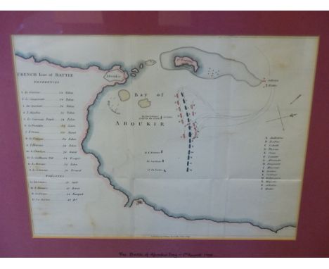
AN EARLY 19th.C. MARINE CHART OF A PORTION OF THE BALTIC COAST, INDISTINCTLY SIGNED AND DATED 1810 AND INSCRIBED 'H.M.S. CENTAUR' AND DATED SEPTEMBER 1808. PEN AND INK AND WATERCOLOUR, 28 x 37cms. TOGETHER WITH AN ANTIQUE HAND COLOURED MAP ENTITLED 'THE BATTLE OF ABOUKIR BAY' 1ST AUGUST 1798 OF THE BRITISH SQUADRON COMMANDED BY ADMIRAL LORD NELSON. 27 x 32cms (2).


Lot 173
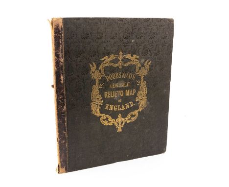
F Calvert - 'The Isle of Wight Illustrated in a Series of Coloured Views' - Published 1846 - numerous aquatints - together with W H Davenport Adams - 'The History, Topography and Antiquities of the Isle of Wight' - 1856 (both needing rebinding) CONDITION REPORTRegarding F Calvert's, 'The Isle of Wight Illustrated in a Series of Coloured Views' -By our judgement, all plates and map present.There are 61 numbered pages.Our team of trusted experts are on hand to help and always endeavour to provide an accurate judgement. The ultimate responsibility lies with the buyer however, and we recommend that you make every effort to inspect the lot yourself.


Lot 1268
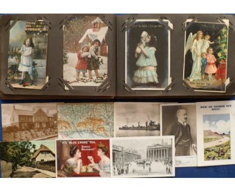
Postcards, a vintage album of approx. 95 cards mostly of children and greetings inc. Santa, embossed, gnome, good RP of High St Harbourne, also Kinsella (Cricket (3)), stamp card sold with 30+ loose cards inc. map of Brighton (postmarked 1904), advertising inc. Bovril, Nestle, Blue Cross Tea etc, a small selection of cards relating to hospitals, children's homes etc (mixed condition, fair/gd)


Lot 152
Souvenir/Ephemera. Collection to include a mounted photographic group portrait taken on board Royal Yacht Britannia, including HRH Princess Alexandra and HRH Prince Philip, Duke of Edinburgh, signed by members of the crew to borders (including Rear Admiral Sir Paul Greening), inscribed, 'To a little lady with a big heart'; three press photographs of HRH Princess Alexandra taken during a royal tour; various travel certificates for Marjorie Dawson; a printed map, 'Voyage of Their Royal Highnesses The Prince and Princess of Wales, August 1981' (43cm by 61cm); a small quantity of tickets and boarding passes for Marjorie Dawson, including Concorde; a small quantity of empty envelopes, some with Royal Family connection, including one plain envelope inscribed by Prince Charles in black ink, 'Miss Marjorie Dawson', with 'C' at lower-left, and one with typed address to Marjorie Dawson, postmarked Buckingham Palace, 29 December 1997, with typed 'C' at lower-left; a collection of mid-20th century used worldwide stamps (loose clippings), with several First Day Covers and Airmail coversProvenance: Marjorie Dawson RVM (1915-2019), dresser and maid to Princess Alexandra
Lot 186
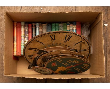
Collection of assorted Biggles and similar books as found (18); a Bacon's "midget" map of London; a cased thermometer by Dakin Bros, London; a small collection of card clocks, planispheres and perpetual calendars; a set of vintage "Peerless" handcuffs, manufactured by Smith & Wesson (with key). In one box
Lot 190
Catlin, George. Letters and Notes on the Manners, Customs, and Condition of the North American Indians, first edition (with 'Frederick' on p.104), in two volumes, London: Published by the Author, 1841, printed by Tosswill & Myers. Large octavo, contemporary embossed cloth with morocco title labels lettered in gilt. Featuring frontispiece, two maps (one folding), one chart, and 310 plates (including plates 113 & 114), the plates and non-folding maps/chart arranged on 75 leaves in Vol.I and 104 leaves in Vol.II. Contents generally very good, clean, bright; occasional light marks and pale spotting in places; folding map is very good and well-preserved; small paper repair to verso of frontispiece; bindings tight and solid; fading to spine/edges; light bumping/wear to cloth at corners/extremities. A very good example of this important work

Lot 20
Birmingham History Interest. Edwardian scrapbook of newspaper clippings relating to Birmingham, compiled by William H. Fox, 1906, 'Collected from Various Sources and as the result of many years labour by William H. Fox'. Quarto, quarter-calf with red cloth boards and paper covers. Together with a manuscript minute book for the Building Committee of St. James's Church, Aston, 1898-1902, in black ink, entries signed by the Chairman, and a Bartholomew Plan of Birmingham (the map detached as found) (3)
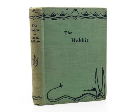
Lot 203
Tolkien, J. R. R. The Hobbit, first edition, first impression, London: George Allen & Unwin Ltd, 1937. Octavo, publisher's decorated green cloth, black & red illustrated map endpapers, frontispiece, nine plates/illustrations (all present as called for), publisher's advertisement leaf at rear. Contents generally very good, clean, bright throughout; some light toning and very faint spotting to endleaves; light crease to front free endpaper; plate facing p.146 with pale dampstaining; lacking dust-jacket; some splitting/loss to cloth at spine/headcaps, the cloth with some marks and discolouration; the boards a little bumped at lower corners; shelf-lean. The true first edition, first impression of Tolkien's debut novel (one of only 1500 printed on 21 September 1937)
Lot 209
Gibson, John; Emanuel Bowen. Atlas Minimus, first edition, London: J. Newbery, 2 January 1758, engraved allegorical frontispiece, title page, Preface, Index (with Errata referring to map of Africa), complete with all 52 hand-coloured miniature maps (numbered), including the Americas, plus publisher's advertisement at rear. Full calf. Contents good, clean, bright; all maps exceptionally well-preserved with bold colours; owner inscriptions to front pastedown/verso of frontispiece; rear free endpaper torn with loss at corner; front free endpaper presumably lacking (no blank leaf before frontispiece); binding solid with bumping/wear to corners and some splitting to joints around headcaps

Lot 21
Mammatt, Edward. A Collection of Geological Facts...of the Ashby Coal-Field, Ashby-de-la-Zouch: Edward Lumley, printed by W. Hextall, 1836. Quarto, complete with folding map, 24 sections of strata (23 hand-coloured), 124 hand-coloured lithographic plates, and seven folding diagrams. Contents generally good, occasional pale spotting/marks, the lithographic plates brightly preserved by protective tissue-guards (one plate torn), rebound in recent tan and green buckram (invoice from bindery loosely inserted). Leicestershire Interest
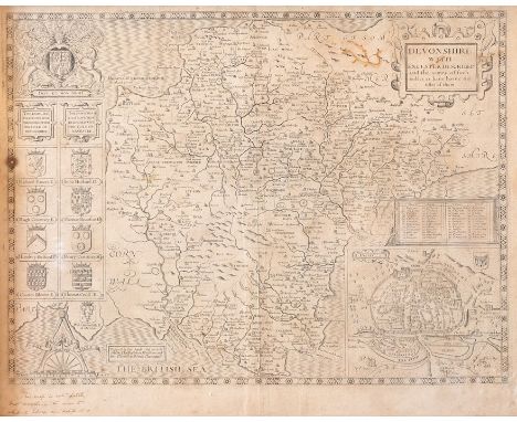
Lot 241
Speed, John. 17th-century map of Devonshire, uncoloured copper engraving on laid/chain-lined paper, published by Bassett & Chiswell. Featuring inset plan of Exeter, royal coat-of-arms, heraldic shields. Framed & glazed, 42.5cm by 54.5cm. Some light toning, old ink inscription suggesting date of 1610, and some damage from worm in one section at upper-right

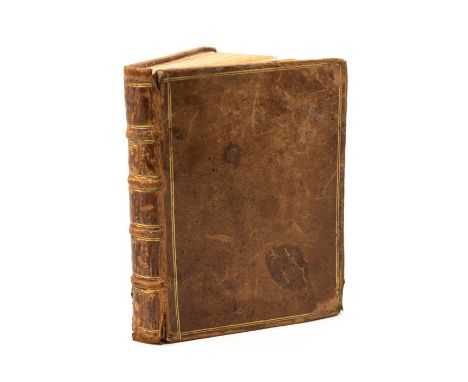
Lot 244
Dobbs & Co. Geological Relievo Map of England. Hand-coloured engraving with varnished finish, embossed design showing the contours of the land, featuring table of geological strata, sectional, linen-backed boards with publisher's quarter-calf embossed cloth lettered in gilt. London: Dobbs & Co., [c.1840]. Generally well-preserved with faint surface wear, light pencil inscriptions, and some splitting/wear to calf spine. Very scarce
![Australia. Map of Van Diemen's Land [Tasmania], hand-coloured engraving, London: Joseph Cross, 26 June 1826. Sectional, linen](https://cdn.globalauctionplatform.com/2a31accd-7a35-40ff-8a60-ac440119e074/aafa97c0-ea8a-4dd1-be51-ac5200ec1274/468x382.jpg)
Lot 245
Australia. Map of Van Diemen's Land [Tasmania], hand-coloured engraving, London: Joseph Cross, 26 June 1826. Sectional, linen-backed, complete with slipcase bearing publisher's paper label. A very rare map, much of the land still blank ('Country not yet explored'), or with basic descriptions of the region ('Extensive Woody Plains'). Very well-preserved with bold, vibrant colours; slipcase with light wear. 82.5cm by 64.5cm. Very scarce
-
109182 item(s)/page