We found 109182 price guide item(s) matching your search
There are 109182 lots that match your search criteria. Subscribe now to get instant access to the full price guide service.
Click here to subscribe- List
- Grid
-
109182 item(s)/page


![LUGARD, Capt. F. D. The Rise of Our East African Empire. William Blackwood & Sons, London, [1893] 1 st ed. 8vo. Presented in](https://cdn.globalauctionplatform.com/de360dc5-b4ff-43c0-bcd5-ab6d00a6d901/8c7ae24c-d428-41d4-9273-ab7300a26dab/468x382.jpg)
Lot 1010
LUGARD, Capt. F. D. The Rise of Our East African Empire. William Blackwood & Sons, London, [1893] 1 st ed. 8vo. Presented in 2 vols in original red publisher’s cloth. Vol1: 29 full page plates and 3 coloured maps, of which one is in the front pocket. Vol 2: 25 full page plates and 5 coloured maps. [2]Condition report: Both volumes professionally rebacked, original backstrips relaid. Volume 1 lacks map from rear pocket.


![Map, Published after the Atlas "Theatrum Orbis Terrarum [1598]" our late 17th century copy ( page 102), in italian editing. L](https://cdn.globalauctionplatform.com/47f69f00-6bb8-474c-b6ef-ab6b009ea16d/07c14139-a201-4f5d-8d7b-ab6b00fdf55b/468x382.jpg)
Lot 5
Map, Published after the Atlas "Theatrum Orbis Terrarum [1598]" our late 17th century copy ( page 102), in italian editing. Large sheet of the album format in plano (57 x 47 cm) in black and white inking, printed on both sides,large map front representing Illyria (Roman province located on the coasts of the eastern shoreof the Adriatic, corresponds to present-day Slovenia, southern Croatia, Bosnia and Herzegovina, Montenegro, Albania and Kosovo ; verso composed of an nice explanatory appendix in Italian. Rare map in very fine condition. I R!

Lot 124
Of military interest, a selection of maps from WWI to the Falklands, a series of maps, possibly from publication showing the Western front and the Guards division advances in 1918, together with a World books reproduction of a map of the Historic wartime journeys undertaken by the right hen. Sir Winston Churchill titled Dunkirk to Berlin June 1940- July 1945, a map of Malaya titled "Rasa" and a Stanley minefield situation map as at 07 Dec 82 stamped "Navigator RFA Sir Geraint 19 Apr 1983".

Lot 5150
WW2 British publications from the estate of a former member of the British 79th Armoured Division to include: Hardback book with dust cover "The Story of the 79th Armoured Division", soft bound book "Royal Armoured Corps", 1942 British Tanks (What they look like, How they work, What can they do) which folds out to a large size poster, "The Westminster Dragoons in North West Europe June 1944-May 1945, published Germany 1945,and a framed coloured map of the 79th's Campaign in NW Europe 74cm x 34cm.


Lot 5002
WW1 British Royal Artillery Medal Group to 157051 Gnr GE Richardson RA, comprising of War Medal and Victory Medal complete with original ribbons and with box of issue a/f, along with his Royal Artillery cap badge with spinning wheel, 1921 edition Soldiers guide "The Indian Empire" with pull out colour map of India, postcard photo of Gunner Richardson with his comrades and a double sided photo brooch showing him in civilian clothes.

Lot 5038
WW2 British Royal Scots Fusiliers Medal group to 14440056 Sgt Cornelius Patrick Williams comprising of France & Germany Star, War Medal mounted on a bar plus Defence Medal loose: spare ribbons, a War Medal with missing suspender: identity disks with Roman Catholic medallion: AB64: Certificate of Service 1943 - 1952: WD Driving permit: Booklet 52nd (Lowland) Division Post War Activities: Prayer book: Post Office Saving Book: Kilt brooch: two Regimental buttons: 1941 dated Glengarry cap complete with badge, size 7, maker marked "JL Currie & Co": Wash Roll: Sweetheart embroidery: Hardback book "Mountain & Flood" the history of the 52nd (Lowland) Division 1939-1946 by George Blake 1950: Hand painted wooden plaques x 2 done in Germany 1946/1948, size 28 cm x 22cm and size 31cn x 24cm: a selection of Staybrite cap badges and collar dogs, large framed map showing the progress of the 52nd (Lowland) Division through North West Europe 88cm x 62cm.

Lot 5119
WW1 Royal Flying Corps and early RAF interest. An outstanding group to 13412 Lt Stuart Leslie consisting of Army Book 425 Pilots Flying Log Book, first entry 29/11/17, final entry 24/10/18, posted to No 4 Squadron on 3/5/18 and saw active service until 24th October 1918 with over 260 hours total flying time both as a Pilot and Observer. The log entries are detailed and include such items as crash landings, number of rounds fired from the Lewis gun, number of bombs dropped, actions with enemy aircraft, anti aircraft fire, photos taken, etc. Also included are his Soldiers Small book dated with enlistment date of 30/10/15 at the age of 22 years. Next of Kin listed as Father, Henry Cliftonville Leslie: RFC Training Transfer Card with posting date 17/11/17, aircraft types flown, DH6, BE2e, RE8, BE2c, BE12. Hours flown since graduation 10.5 on the RE8.: Booklet "Questions and Answers on the Practical Application of SS 131 for Pilots & Observers, RAF. 2nd Wing RAF", named in pencil to front cover: Form from Artillery & Infantry Co-Operation School, Pilots School with marks on Artillery Co-Operation etc for a 14 day course: Form from the Artillery & Inf Co-Operation school stating on transfer no Clothing statement received from No 69 TS: dated 28/4/18: Three sheets of Foolscap size Standing Orders issued at No 5 School of Military Aeronautics, RFC, Denham Bucks, Sept 1917: A card bound cover loose Lecture book containing all his notes with drawings detailing, aircraft rigging, engines, Ariel observations, Map reading, Instruments, Bombs etc: "A" Form Messages & Signals dated 31/101918 telling him and two other officers to proceed to Armentieres Station signed "Good Bye and best wishes": 9 small rolls of gun camera photographs which are dated 24/7/18 or 25/7/18 and additionally marked Lt Leslie, each showing 4 frames of images, these dates are covered in his log book where it mentions "Camera Gun" on July 24th 1918 and on July 26th 1918: A pair of screen printed aircraft pennants wrapped in brown paper, one a Union Flag measuring 22cm x 12cm complete with tie strings which shows evidence of use and a RAF "Duster" pennant 23cm x 11.5cm: RFC Bronze Sweetheart badge, solid back, pin missing, converted from a collar dog maker marked "JR Gaunt, London": 3 RFC Officers Bronze collar dogs, all unmarked: Wire Bullion Miniature Mess Dress RFC Pilots wings measuring 7.5cm: Pair of RFC Pilots Wings cut from uniform with tunic material remaining, approx 11cm across: A pair of RFC Pilots wings uniform removed, approx 11cm across: A pair of RAF Pilots wings in padded form, uniform removed with threads remaining approx 10cm across: A pair of RAF Pilots wings in padded form uniform removed approx 10cm across: Early RAF cuff rank insignia eagle and metal wound stripe, uniform cut off removed: Single cloth Wound Stripe in wire bullion, uniform cut off removed: Single rank shoulder strap shows evidence of promotion from Lt to Captain as pip differs slightly in style, uniform cut off removed, press stud to underside: Small 31mm gilt RAF eagle with twin prongs to reverse maker marked "Lambourne & Co, Birmingham": Metal Wound Stripe with backing plate: Cloth ribbon bar with War Medal & Victory Medal ribbons and another the same but pin backed: 4 heavy card map boards for use in the aircraft with maps pasted to them showing the Front Lines, Hostile Battery Positions, named to him: A single sided cardboard map board showing Light Railways in Corps area 1918: Six other folding maps showing Belgium and France. Photo of Stuart Leslie in the family home, postcards, pre war German business cards, his Father's 1915 driving licence, etc. All contained within a wooden Teachers Whisky box. Background info: Stuart Leslie was born in Finchley, North London on 19th May 1893 to Henry Leslie and his wife Madeline Nora. He had three younger sisters. In 1911 he was listed in the census as being aged 18 and an "Apprentice, Trimmings, Haberdashery". After the Great War he returned to the family home "Cliftonville", Woodhouse Road, Finchley N12 and to the business. In 1939 he was living with his Mother and two sisters still at the family home and listed as being "Manager Straw and Felt Merchant". He never married and died in 1950.

Lot 364
A SMALL QUANTITY OF COLLECTABLES to include a c.1915 Stefan Schwartz bronze Rando dancing putti relief plaque (approx. 3" square), a small micromosaic picture frame, a nut paperweight, celluloid cigarette case, fishing reel and World War trio era silk map 44c South Burma, part Siam and part French Indo China contained in a carved wood bowl


Lot 87
JANSSON MAP OF STAFFORDSHIRE AND SHROPSHIRE, 17th Century, with early hand colouring, framed and glazed, frame size 60 x 68 cm together with Blaeu map of Staffordshire, 17th Century with later hand colouring, frame size 59 x 67 cm (2)Condition Report:Jansson - appears to be very good condition, good margins, good plate markBlaeu - has over all browning and various creasesNot inspected out of frames.


Lot 162
ARROWSMITH J. Central Asia comprising Bokhara, Cabool, Persia, The River Indus & Countries Eastward of It ... Surveys of Lieut. Alex. Burnes. Fldg. eng. linen map, hand coloured in outline. 20½" x 29½". Recased. 1834. Burnes, the famous Central Asian traveller published his well known work, Travels into Bokhara, in 1835.
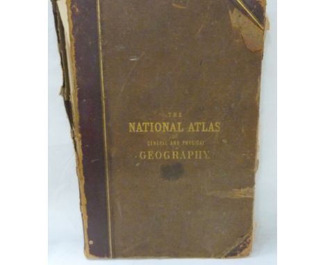
Lot 163
JOHNSTON A. K. The National Atlas of Historical, Commercial & Political Geography. Poor cond. but many good double page eng. maps (the maps loose but generally clean). Folio. 1855; also a poor copy of Bacon's Large Scale Atlas of London & Suburbs, quarto with col. maps, n.d. Both vols. a.f. Johnston National Atlas missing map 32 - Tasmania/Van Diemen's Land, and map 39 - United States & Texas. Only the maps have been collated, not text. Other volume not collated.

Lot 173
SAXTON CHRISTOPHER. Cestriae (Cheshire). Antique hand coloured eng. map. 11" x 12", rolled, c.1610.Condition report:Condition as images.Some foxing, chipping and tears to margins, and a further few tiny pinholes mainly on left hand side. Quite close cropping to plate mark. "33" inscribed in sepia ink bottom left corner.


Lot 2060
Mainwaring (Maj. Arthur) & Wylly (Col. H.C.) Crown and Company. The Historical Records of the 2nd Batt. Royal Dublin Fusiliers, 1662-1922, Cork: Schull Books, 2000, three volumes including map case, limited edition of 200, numerous plates, 6 folding maps as called for, original cloth, slipcase; Gretton (Lt.-Col. G. le. M.) & Geohegan (Br.-Gen. Stannus), Campaigns and History of the Royal Irish Regiment, 1684 to 1922, Cork: Schull Books, 1997, three volumes including map case, numbered limited edition of 200, ten plates and nineteen maps on seventeen sheets as called for, original cloth, slipcase; Whitton (Lt.-Col. Frederick), The History of the Prince of Wales Leinster Regiment (Royal Canadians)..., 1760-1922, Cork: Schull Books, 1998, three volumes including map case, numbered limited edition of 200, twelve plates and eighteen maps as called for, original cloth, slipcase; Jourdain (Lt.-Col. H.F.N.) & Fraser (Edward), The Connaught Rangers... Cork: Schull Books, 1999, three volumes, limited edition of 200, (publisher's reserve), numerous plates and maps, original cloth, slipcase; Jervis (Lt.-Col. H.S.), The 2nd Munsters in France. Cork: Schull Books, 1998, plates and maps as called for, original cloth (5)

Lot 2069
Clarkson (Christopher) The History and Antiquities of Richmond in the County of York, with a Brief Description of the Neighbourhood, Richmond; Thomas Bowman, 1821, quarto, folding map frontis, engraved title, plates and folding pedigrees as called for (Boyne p.181-3), minimal early annotation, half calf by Brown of Durham (re-backed) [Provenance; 'From the author to ... James Gordon', then bequested to Rev J. Raine who gifted it to George Ornsby]
Lot 2070
Wrawby Farm Wrawby Farm Account Book, 1839-1856, interesting manuscript accounts (one page for May 1854 has been removed), original vellum binding (worn). Loosely inserted is a manuscript map of land intersecting the Market Weighton Canal and the road from Howden to North Cave. [Wrawby is a village in North Lincolnshire]

Lot 2071
Fox-Strangways (C.) The Jurassic Rocks of Great Britain, Vol 1 - Yorkshire, HMSO, 1892, folding colour map frontis, five folding maps as called for, original cloth; Mackie (S.J.), The Geologist, A Popular Monthly Magazine of Geology, 1861, colour frontis, plates, some folding, half calf (worn); Callon (J.), Lectures on Mining delivered at the School of Mines, Paris, translated by Foster & Galloway, Delau & Dunod, 1876, three atlas volumes, 119 double page plates, childish scribbling to reverse of some plates, mixed bindings; An album of press cuttings relating to mining (late 19th century); with eight volumes relating to Teesside industrial history and the Transporter Bridge (14)


Lot 2083
Thoresby (Ralph) Ducatus Leodiensis: or, The Topography of the Ancient and Populous Town and Parish of Leedes, and Parts Adjacent in the West-Riding of the County of York ..., Atkins and Clements, 1715, folio, portrait frontis, folding map, plates as called for, plus additional folding prospect of the Leeds Cloth Hall, contemporary calf gilt (worn, joints cracked); Smith (C.), Smith's Classical Atlas .., 1817, quarto, thirteen maps on twenty-one pages as called for, hand-coloured in outline, binding worn, boards detached (2)
Lot 2085
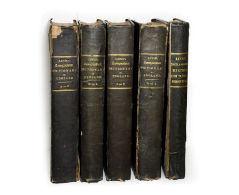
Lewis (Samuel) A Topographical Dictionary of England ..., S. Lewis, 1835, third edition, five quarto volumes including the Parliamentary History volume, folding map of England and Wales, engraved maps throughout the first four volumes, 116 maps (hand-coloured in outline) in Parliamentary volume, original cloth (worn)
Lot 2087
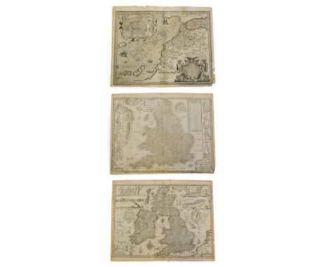
John Speed 'The Kingdome of Great Britaine & Ireland', William Humble, 1653, uncoloured map, engraved by J. Hondius, plate mark 387mm x 515mm, English text verso, margins frayed and chipped, split through South West England; Saxton (Christopher) & Speed (John), 'The Kingdome of England', William Humble, 1649, uncoloured map, engraved by Abraham Goos, plate mark 390mm x 515mm, English text verso, print not sharp, margins frayed and torn, small hole in Irish Sea, split at lower fold; Ortelius (Abrah.), Fessae et Marocchi Regna Africae Celeberr, 1595 [1606 or later], uncoloured engraved map of Fez and Morocco with inset map of Congi Regni Christiani in Africa, after Philippo Pigafetta, plate mark 394mm x 505mm, English text verso, wear to lower right corner with loss to border, some fraying of other margins [van den Broeke #177] (3)

Lot 2088
Walker (J. & C.) A Geological Map of England, Wales and Part of Scotland, Showing also the Inland Navigation by Means of Rivers & Canals With their Elevation in feet above the Sea, Together with the Rail Road & Principal Roads, no date [1835 or later], hand-coloured folding map, dissected into 36 sections, linen-backed, 1435mm x 1000mm overall, in book form slipcase


Lot 2090
Bowen (Eman.) An Accurate Map of the County of York, Divided into its Ridings and subdivided into Wapentakes .., nd., hand-coloured map, approx 440mm x 510mm, mounted, framed and glazed; Blome (Richard), The North Ridinge of Yorkshire, 1672, hand-coloured map, approx 250mm x 310mm, mounted framed and glazed; Morden (Robert), The East Riding of Yorkshire, hand-coloured map, approx 360mm x 420mm, mounted, framed and glazed; with two others (5)


Lot 2093
Salt (Henry) A Voyage to Abyssinia and Travels Into the Interior of that Country ...., F.C. & J Rivington, 1814, quarto, two vignettes, thirty-five maps, charts and plates on thirty-four sheets (five folding including large coloured map) as called for, faint library stamp on title verso, label scars to front endpapers, quarter leather library binding
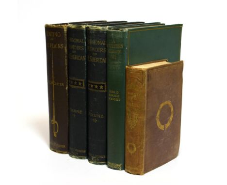
Lot 2095
Custer (Mrs E.B) Tenting on the Plains or General Custer in Kansas and Texas, New York; 1887, first edition, portrait frontis, original cloth gilt (owner's name to title page); Sheridan (P.H.), Personal Memoir of P.H. Sheridan, General United States Army, New York; 1888, two volumes, portrait frontis to each, original cloth gilt (owner's name to title page); Tytler (Patrick Fraser), Historical View of the Progress of Discovery on the More Northern Coasts of America, 1833, folding map frontis, original cloth (owner's name to title page); Wright (Mrs D.G.), A Southern Girl in '61, 1905, portrait frontis, plates, original cloth (owner's name to title page) (5)
-
109182 item(s)/page