We found 109198 price guide item(s) matching your search

Refine your search

Year

Filter by Price Range
  • List
  • Grid
  • 109198 item(s)
    /page

Lot 296

A rare WWII Nazi Germany propaganda surrender booklet The two piece booklet with a map of the Allied armies situated near Dunkirk and Bruges surrounded by the German army, with script in French and British 'British soldier! Look at this map: it gives you your true situation! your troops are entirely surrounded- stop fighting! Put down your arms!' pencil date 1940, also a WWI period greetings message from British army soldier from Egypt dated 15th April 1916. (2)

Lot 82

Pair of brass candlesticks, silver plated trays and candelabra, map print, glass, china and collectables

Lot 1048

Lewis's Atlas of Ireland, pub London 1837, with engraved country maps and fold-out country map, to/w an 18th century calf-bound French volume by M. L'Abbe de la Caille, 'Journal Historique du Voyage Fait au Cap de Bonne-Esperance' (Cape of Good Hope), pub Paris 1763 (2) Condition Report Irish vol - 32 maps - the frontice folding map torn top left corner across from spine approx 5 cm otherwise all ok

Lot 1106

A map engraving, 'L'Empire des Turcs a Paris Chez Crepy 1767', to/w a set of five French map engravings and another, similarly framed (7)

Lot 1108

A 17th century Dutch map engraving after Gerard de Jode, depicting Holland and Belgium 'Germania Inferior', 34 x 44 cm, mounted, framed and glazed

Lot 1132

A Victorian album of pencil sketches including well executed equine studies with anatomical details and annotations, dated 1883, to/w an olive wood souvenir album (empty) a postcard album, Philip's Excursion map of London, large photograph of HMS York in Miraflores Locks, Panama Canal 1934, various souvenir photo-cards, crested ware china bulldog and sailor, vintage bus tickets, pair of leather gaiters, etc.

Lot 1139

Smith's New Map of England & Wales 1821, folding linen-backed 120 x 96 cm, in original printed and oil-board slip-case Condition Report Case repaired with modern panel-tape

Lot 1281

A DISTRESSED VICTORIAN CHAIR, another chair, box of metalware, two briefcases, framed map of Staffordshire etc

Lot 1537

AFTER BELLIN, Carte Reduite Du Golphe Du Mexique, a hand coloured map of the Carribbean, 23cm x 32cm

Lot 1538

J & C WALKER, map of Lancashire, 1806, hand coloured, 37cm x 23cm

Lot 1539

AFTER HUTCHINSON, a correct map of Lancashire, together with two maps of Cheshire (3)

Lot 1545

KIP AFTER NORDEN, map of Hertfordshire, later hand colouring, 29cm x 35cm

Lot 552

5 items of Railwayana/memoribillia - a Coach interior Brass Lamp, a Signal lever plate, a brass Toilet Door Vacant/Engaged sign, an LMS Engineering Department Atomiser Lubrication notice dated 1934 in a metal holder and a LSWR Carriage Route Map.

Lot 563

A tray containing Plaques of King Class 4-6-0 'George V' and a Class 52 Western Diesel cast in the BR Foundary at Swindon with LE Certifictes, an Aluminimum Map from the interior of a BR(E) Suburban Coach showing Eastern Region Routes from Liverpool and Fenchurch Streets to Clacton, Bishops Stortford etc, an Engine Driver/Firemans Cap, a repainted cast iron L&Y Ry Co loading plate dated 1918, and other items.

Lot 203

A Framed Repro Domesday Map, Shropshire.

Lot 565

After Blaue, Leicestrensis Comitatus, a hand coloured map, framed and glazed, 38.5cm x 50cm, together with after Ogilby, The Road to from London to Derby, hand coloured (2).

Lot 576

After Dean Wolstenholme, The Death of Tom Moody, Gone to Earth, colour print with a verse, 41cm x 42cm, four prints St Albans Steeple Chase, a map, print of an Errand Boy, hunting print after John King and a reproduction map of Cottesmore Hunting Country (9)

Lot 582

After Hondius, The Countie and Citie of Lincolne (Lincoln), hand coloured map, 38cm x 51cm, also a map of Rutland, hand coloured, glazed and frame (2).

Lot 356

Herman Moll, "Leicestershire" county map, sheet size, 22 x 33cms and four other county maps of Leicestershire, (5)

Lot 1143

Two framed maps of Reigate, showing architectural and historic buildings, framed map of Surrey and other various framed prints of local interest

Lot 1313

Antique handcoloured map of Middlesex by Robert Morden, 15ins x 17ins

Lot 1329

18th Century handcoloured map of Staffordshire by J. Cary, 11ins x 8ins, together with four various other prints and engravings and an Ordnance Survey folio of maps of Great Britain

Lot 1394

Robert Morden map of Somersetshire together with an early framed map of Sussex, published 1812 by S.A. Oddy

Lot 1400

Pair of small gilt framed hunting prints, together with a small map of Hampshire, four 20th Century embroidered pictures and two other pictures

Lot 87

Late 19th Century jigsaw puzzle of Scotland with map in wooden box, educational spelling game in wooden box and four Mercedes Matchbox and Dinky toys, unboxed

Lot 554

WWII second world war Nazi Battle Shield July 42 KRIM (Crimea) depicting an eagle above swastika, with dates 1941 /1942 and then an impression map of the Crimea. 4x pins to reverse

Lot 6

Visitors Guide to Bristol and Clifton by Charles Challenger and Edward Everard Published by the Bristol Tramways and Carriage Company Ltd. Includes fold out map Circa 1910. Together with A New Guide to Bristol and Clifton and the Bristol Channel Circuit, Edited by James Baker FRGS , Print Second Thousand (2)

Lot 323

After Robert Morden, Map of Wiltshire, together with another of Berkshire, 37cm x 43cm. (2)

Lot 413

A map of Middlesex from Bartholomew's Library, 30cm x 45cm.

Lot 414

After E. Bowen, Riven Map - Bristol to Cirencester, with later colouring, together with another Riven map, four county maps and a reproduction of England XI 1847. (7)

Lot 246

After Willem and Johan Blaeu, a reproduction coloured map of Britain. Framed and glazed

Lot 438

A large framed WWI coloured “Daily Mail War Map” of Europe, together with comparison of the size of the opposing armies, number of ships, aircraft, etc, 31” x 21”; a large framed copy of a sepia photograph of children at the seaside looking towards an airship, 23”x 33”; a framed coloured print of a US Navy airship and aircraft in clouds, 30” x 20”; and a framed coloured poster showing the SS Queen Mary at Long Beach, California, with a Goodyear airship in the background, 25” x 37”. GC (4)

Lot 1570

An engraved map view of the Isle of Malta

Lot 1573

An antique Robert Morden map of Derbyshire

Lot 1574

An antique Robert Morden map of Ireland

Lot 1575

An antique Robert Morden map of part of Hampshire

Lot 1576

An antique Robert Morden map of Norfolk

Lot 1577

An antique Robert Morden map of Middlesex

Lot 1578

An antique Robert Morden map of Northumberland

Lot 1579

An antique Robert Morden map of Hertfordshire

Lot 1580

An antique Robert Morden map of Kent

Lot 1584

A large framed map of Essex dated 1804

Lot 1648

A bag of aviation maps, a silk map 'Restricted of Vienna 1953"

Lot 2093

A quantity of Pictures including Still Life of fruit, two pastel portraits, a framed map of The City and University of Oxford, etc.

Lot 118

RAC ITINERARY DIRECTIONAL MAP AND ASSORTED EPHEMERA, VARIOUS LIGHTS AND LENSES AND TWO LARGE LUCAS HEAD LAMPS

Lot 338

A folder of 19th century and later engraved maps Condition Report / Extra Information Expedition map - 'The Expedition of Shalmaneser King of Assyria against the Syrians and the Ten Tribes of Israel showing the Countries to which they were carried into Captivity', Measures 24 x 37cm.

Lot 508

Mixed lot to include slipper pan, cased dessert knives, and leather cased map books

Lot 646

Framed and printed scale map of the world; and a reproduction of the Epsom Races 1847 (2)

Lot 705

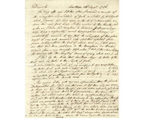
SMEATON JOHN: (1724-1792) English Civil Engineer who was responsible for the design of bridges, canals, harbours and lighthouses including the Eddystone Lighthouse (1755-59). A.L.S., J. Smeaton, two pages, 4to, Austhorpe, 22nd August 1786, to Dr. [Charles] Blagden at Whitby. Smeaton states that he has received a minute of the Longitude and Latitude of York, remarking that he looks upon it ‘as the best determination we have had: and York being pretty central to the County; and so far as I have had occasion to examine Jeffereys Large map, being a reasonably exact topographical survey, it immediately occurred to me that the Longitude of this place might be very well compared with what had resulted from former determinations: the best of which was, as I told you, one that had been put down in the Connoisance de temps deduced from a very accurate observation I had of the suns eclipse the morning after the Transn. Of Venus of 1769, which was 5’, 43” ‘ , continuing to provide his calculations for Austhorpe and explaining that they agree better with his own observations than those of the French, commenting on the effect that the recent weather has had on his observations, ‘I kept my letter open in hopes to have got a transit of the sun; to have ascertained the going of the clock since the 16th and this morning afforded some transitory gleams….and then came on a great black cloud….’ In a lengthy postscript Smeaton refers to his correspondent’s visit to the Pier and works at Whitby, where he should meet Mr. Pickernell, the engineer, remarking ‘I recommended him to the trustees upon the merit of his having acquitted himself, not only to my own, but every ones satisfaction, as resident surveyor to my unfortunate work of Henham Bridge’ and further writing ‘Ruswarps Mill near Whitby has been esteemed one of the most curious in the Kingdom; it was built about the time I first begun to direct works of that kind, and is one of the best specimens of the state of the art, about the year 1754: it has many very ingenious contrivances about it: but it is totally deficient in that branch of the art, that I have principally cultivated; that is the art of producing the greatest degree of Power, with a given quantity of water and fall’. With integral address leaf post marked at Ferry Bridge and bearing a good red wax seal (small area of paper loss where broken). A letter of excellent content. VG Charles Blagden (1748-1820) British Physician and Scientist, Secretary of the Royal Society 1784-97.

Lot 1065

A large framed and glazed Map of York Town.

Lot 1100

A print of a Robert Morden Map of Gloucestershire, a print of a Map of Devonshire plus a small Print of a map of Cornwall together with a modern poster for the London Palladium

Lot 1180

A framed Map of 'Breknoke, both Shyre and Towne defcribed'' by John Speed, hand coloured

Lot 1181

Four early framed Maps of Monmouthshire, the largest being 63 cms x 56 cms and including ''New Map of Monmouthshire'' by John Cary and another by H. Moll

Lot 1332

A small quantity of Bartholomew's Maps, a Bradshaw's Railway Map dated 1907 for Great Britain and Ireland, together with a quantity of Postcards.

Lot 1341

A small framed and mounted Map of Brecknockshire, 7 1/2'' x 9 1/2''

Lot 1364

A framed and mounted Map of Brecknock together with a Langley's new Map of Brecknockshire and a certificate of the Diocesan Guild of Bell ringers.

Lot 1396

A W.H. Toms Map of Leicestershire 1742

Lot 347

Joan Blaeu (1596-1673), a hand coloured map of Monmouthshire, 48cm x 50cm in an ebonised glazed frame.

Lot 363

A collection of pictures and prints, to include: a hand coloured engraved map of Cumberland, several landscapes in watercolour and others, various sizes and mediums.

Lot 55

1763 DETROIT MAP FROM BELLIN'S 1764 ATLAS, H 8", W 12" [ARTWORK]: "Depuis le lac Saint Claire jusqu'an Lac Erie" "Echelle de deux Lieues Communes. Tome1 , No. 12. French. Dated by Ira & Larry Goldberg Coins & Collectibles and described in their July 9, 2011 catalogue as: "First Printed Map of Detroit, c. 1764. La Rivière du Détroit Depuis le Lac Sainte Claire jusqu'au Lac Erié. Engraved for Jacques-Nicolas Bellin [1703-72] after Ensign Gaspard-Joseph Chaussegros de Léry.___ Date depicted: 1749. Published in Jacques-Nicolas Bellin, Le Petit Atlas Maritime [5 vols., Paris, 1764], vol. 1, map 12 [at upper right: 'Tome I. No. 12']. A plan of the fort of Detroit designates the Commandant's quarters, the guardhouse, the church, the powder magazine, and the quarters of the chaplain."

Loading...Loading...
  • 109198 item(s)
    /page

Recently Viewed Lots