We found 109198 price guide item(s) matching your search

Refine your search

Year

Filter by Price Range
  • List
  • Grid
  • 109198 item(s)
    /page

Lot 626

A selection of railway ephemera including Wilson's map of Northumberland, carriage prints, Whitbread 1965 calendar etc

Lot 216

An edition of Who's Who 1975; Barrack Room Ballards by Rudyard Kipling; various other books; a map of the Midlands; and a small quantity of LP's

Lot 179

A framed gas attack poster, gas mask and WWI flight book, German map of Belgium

Lot 607

MAP OF DORSET, 40cm x 60cm, framed and glazed.

Lot 562

After Ioanne Baptiste Falda (Italian, 1643-1678): Novissima et Accuratissima Romae Veteris et Novae Tabula, a hand coloured street map of Rome, first published circa 1694, engraved by Pietro Monico, from Thesaurus Antiquitatum Romanerum, a 19th century hand coloured print, with plate mark, 48 by 60cm, framed, 51 by 63cm.

Lot 668

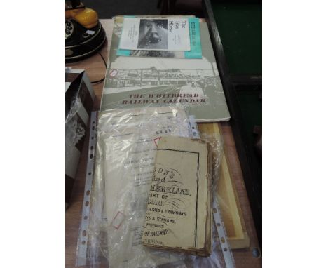
Kelly's Directories Ltd., London, 1900 Johnson, a large black and white map of London split into 4 parts, each part in 15 sections, includes index to streets and places in London First Edition, cloth. Military Ordinance survey maps of the 1930's and a Michelin Guide 1923. (26)Provenance: The Estate of Mr Joseph B. Hay, son of Major-General Arthur K. Hay DSO OBE - 100 years of a military family.

Lot 536

Hand tinted map of Tweedail by W N J Blaeu circa 165441x50cm, script verso, framed and glazed, loose map of the County of Kincardineshire circa 1822 together with three hand tinted road maps by E Bowen circa 1736, to include London to Holy-head, showing the route through Anglesey, London to Poole, showing Hampshire and the Isle of Wight, Warrington, each map 9x12cm, further map of Yorkshire North Riding circa 1800 and further map of Rutlandshire circa 1821, all framed and glazed.
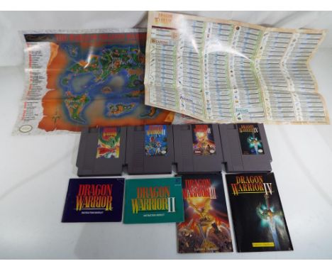
Lot 555

A printed canvas topographical hanging wall map of ParisThe plain unstained canvas stamped in monochrome with details of Paris plan map, with black painted wooden surrounds, 18x102cm.

Lot 1018

A copy of a Map of Somersetshire by J. Cary, 11" x 9"

Lot 1076

Miscellaneous old tins, Moroccan leather wallet, Ordnance Survey map, etc.

Lot 1003

A reproduction oleograph map of St Edmundsbury, with topographical views, after the original by Thomas Warren

Lot 251

Alfred R Blundell, 1883-68, views of Norfolk, Suffolk and Italy, signed etchings, together with a Robert Morden map of Suffolk print, and William Farley, signed etching, 18 x 30cm and another

Lot 244

A German leather map case

Lot 403

Assorted prints including a world map, cigarette cards advertising plaques, etc.

Lot 665

A collection of pens, pencils including rolled gold, map gauge, blotter, etc.

Lot 708

A Stereoscopes Universal Type SV.3 map viewer, marked C.F.C. B796, with carrying box

Lot 73

Nintendo - Four Nintendo NES game cartridges (unboxed) comprising Dragon Warrior, Dragon Warrior II, Dragon Warrior III and Dragon Warrior IV with instruction booklets and map and weapon, armour and item chart from Dragon Warrior IV. - This lot MUST be paid for and collected, or delivery arranged, no later than close of business on Tuesday 16th January. Please do not bid if you are unable to comply.

Lot 492

GOOD COLLECTION OF CIGARETTE CARDS along with a collection of coins, cigarette dispenser and a universal map measurer.

Lot 107

An Emmanuel Bowen map of county Durham together with a smaller map of North and East Ridings of Yorkshire, by Robert Morden (2)

Lot 109

A Regency style convex mirror in gilt frame with eagle emblem to top together with an arched gilt framed mirror, printed map of Kent and two early prints

Lot 112

An early map of the East Riding of Yorkshire

Lot 114

An early map of York and surrounding area

Lot 322

A Sheffield General Plan of Proposed Tramways 1872, by Pawson & Brailsford approximately 50 x 81cm (framed), and Sheffield Corporation proposed tramways 1936-37 map.

Lot 333

A 'Neepsend' Coach Works' Brass Wall Sign, Ordnance Survey map, Chinese prints, calendars.

Lot 211

A collection of copper ware to include a beaten copper water vessel, a copper cooking pan with iron handle, copper kettle, a haystack measure, etc and a modern copy of Christopher Saxon's "Map of Wiltshire"

Lot 3

Two boxes of various china wares to include meat platters, tea wares, etc, and a copper tray engraved with map of the world

Lot 385

A Victorian ebonised and mother of pearl inlaid cane-seated bedroom chair, a modern red upholstered adjustable stool, a lacquered and chrome-plated occasional table, marble and hardstone chess table with chess pieces, three various marble type occasional tables, a metal framed convex wall mirror, gilt framed rectangular wall mirror, pair of occasional tables with map inset tops

Lot 172

Map of The World published by H. Warren and engraved by J B Allen, the map drawn and engraved by J Rapkin; together with three further examples, The Isthmus of Panama, Mexico, California and Texas and finally West India Islands, all framed, each 10.5" x 13.75"; together with a large quantity of further prints A Spy print entitled 'Cunarder', a print after Diana Wythe Tyler, The Goodspeed Opera House, River Valley, Connecticut, another print entitled 'Harbour, St. Georges - Bermuda' signed artist proof black and white and others (a collection)

Lot 184

J* Murray - study of a bird on the branch of a tree, signed and dated '81 (1981), pencil and watercolour heightened with white, oval, 11" x 8"; also a companion (a pair); together with an old map of Cornwall by Badeslade and published by H Toms, September 29th 1742, hand coloured, 6.25" x 6" (3)

Lot 307

Large modern mirror with printed decoration of the map of the world, 45" wide; together with a contemporary abstract print, both framed. also a cane work coffee table 17" high, 41.5" wide, 22" deep (3)

Lot 30

Christopher and John Greenwood - 19th Century hand coloured engraved map - The County Of Somerset From An Actual Survey Made In The Years 1820 & 1821, published by Greenwood & Co, 57.5cm x 69cm, framed and glazed Condition:

Lot 433

Josiah Conder, The Modern Traveller 1830, Arabia, one volume map and plates, half leather bound with gilt emblems and four raised bands Condition report: Excellent condition

Lot 432

Josiah Conder, The Modern Traveller 1830, Palestine, one volume, map and plates, half leather bound with four raised bands and gilt emblems Condition report: Excellent condition

Lot 426

Thackers Map of India 1907, coloured map in blue buckram case, 28 segments on linen size 36ins x 40ins, 64pp index includes smaller maps showing tea districts, produce, Bombay, Calcutta and Madras Condition report: Very good condition

Lot 249

A framed and glazed map of Lancaster as in 1610. Approx. 34.5 x 46cm. Please Note: All enquiries will be responded to after we re-open in the new year on 3/1/2018.

Lot 530

A group of five maps of London including two Bacon Gem maps , a map of the branches of Barclays Bank from 1938 , a large folding map of London by Alexander Gross and a Bacon map of Essex , Hertford , Middlesex and London.

Lot 101

MILLHOFF, Geographia Map Series, complete, sectional, VG to EX, 50

Lot 82

Pictures and Prints - a framed map of Staffordshire ; framed coloured lithograph prints, Derwentwater , Borrowdale; etc (8)

Lot 93

A 19th century brass pocket compass; a Rotameter map distance measuring instrument (2)

Lot 161

A map, Halifax to Delaware, North America, East Coast

Lot 423

ROBERT MORDEN, NOTTINGHAMSHIRE, DOUBLE PAGE ENGRAVED MAP, HAND COLOURED, 36 X 44CM, A WATERCOLOUR OF WYEDALE BY B. J. MCVEY, AN EARLY 19TH C HAND COLOURED AQUATINT OF NOTTINGHAM CASTLE, ETC

Lot 427

A REGENCY LINEN OVAL MAP SAMPLER OF ENGLAND AND WALES, BY MARY DEAN, 1817, 49.5 X 43CM, MAHOGANY FRAME

Lot 442

A rare George III engraved and hand-coloured imaginary map paper fan, the 'Land of Matrimony', with islands 'ENCHANTED', 'Coquet' and 'Divorce', and ''Bay of Repentance', titled 'A MAP OF THE WORLD', printed by T. Pike, King Street, Bloomsbury, May 1st 1788, with woden guards and sticks, 23.5cm long. See Sotheby's, Travel, Atlases, Maps & Natural History, 15th November 2011, lot 10 for a similar fan.

Lot 444

A rare George III engraved map of Bath, titled 'A Map of 5 Miles round the City of Bath...from an actual survey made by Thos. Thorpe with Alterations & Improvements to the present time 1773', printed for and sold by W: Frederick & W. Taylor Booksellers, W. Hibbert, Bath Sculpt., published 25th March 1773, 43 x 43cm in a later glazed ebonised frame.

Lot 445

After John Ogilby. 'The Road from LONDON to WEYMOUTH', a hand-coloured engraved strip map, late 17th / early 18th century, 34 x 46cm, in a later mounted, glazed Hogarth type frame.

Lot 654A

A BRASS FIRE SCREEN WITH INSET MAP OF BRITAIN

Lot 21

A FRAMED AND GLAZED MAP OF STAFFORDSHIRE TOGETHER WITH A SET OF FOUR PRINTS (5)

Lot 317

James Sherriff's Map of the Town of Birmingham, Upwards of 25 Miles Round To his most sacred Majesty George the Third, published September 20th 1798 by James Sherriff and William Faden Engraved design and cartouche with explanations, linen backed and preserved in card slipcase, 73.5 x 87cm

Lot 466

A collection of ephemera to include 1920's autograph albums filled with sketches, a Coronation map of London 1937, various correspondence, photographs, a postcard album, Victorian photographs including Bath together with a small suitcase

Lot 485

John Speede map of Stafford Countie and Towne with the ancient citie Lichfeild (sic) described, framed in a double sided glazed frame, 40 x 52cm

Lot 486

An 1853 hand coloured map of Jerusalem or City of The Lord by John Purnell, 65 x 64cm

Lot 487

A framed 17thC hand coloured map of two regions of France by Joachin Blanchon, engraved with buildings, approximately 52.5cm x 42cm

Lot 488

A framed 17thC hand coloured map of Norfolk by Robert Morden, sold by Abel Swale, Awnsham and John Churchill, c1695, approximately 37cm x 59cm

Lot 489

'An Accurate Map of the Counties of Gloucestershire and Monmouth' 1760 with cartouche "To John Thynne Hon Lord Chedworth" printed for Carrington Bowles, St Pauls Churchyard, 53 x 69cm

Lot 490

A framed 17thC John Speede hand coloured map of Surrey, with inset panels of Richmont and Nonsuch Palaces together with Arms of various Earls of the County, with later additional colouring, 45 x 53cm

Lot 491

A framed 17thC hand coloured strip road map by John Ogilby (1600-1676), The Road from London to Bristol, approximately 44.5cm x 33cm

Lot 492

A framed 17thC hand coloured strip road map by John Ogilby (1600-1676), The Continuation of the Road from London to Bristol, from Ogilby's Britannia vol I c.1675

Lot 493

A framed 17thC hand coloured map of Kent by Michael Drayton (1563-1631), engraved with allegorical figures, as published in 'Poly-Oibion or Chronological Description of all the Tracts, Rivers, Mountains, Forests, and Other parts of the Renowned Isle of Great Britain', 1612 and later, approximately 33cm x 25cm

Lot 494

A reproduction of a 17th/18thC map of Gloucestershire

Loading...Loading...
  • 109198 item(s)
    /page

Recently Viewed Lots