We found 109182 price guide item(s) matching your search
There are 109182 lots that match your search criteria. Subscribe now to get instant access to the full price guide service.
Click here to subscribe- List
- Grid
-
109182 item(s)/page


Lot 107
Flintshire, engraved coloured map for Sudbury and Humbel, 1610, some damage and retouching to lower corners, 38 x 50.5cm; Domus Senatoria Antwerpiensis, 17th century etching, 23.5 x 31cm; After Basire, Plan of Antwerp, late 18th engraving with hand colour, 40 x 48cm; 'New Aberdene from the Blockhouse', 18th century hand coloured engraving, 25 x 42.5cm (4)


Lot 112
Huntington Both Shire and Shire Towne, hand coloured engraved map for George Humbell, late 17th century, 38 x 51cm (toned); Lincolnshire, published by Bassett and Chiswell, c.1676, 39.5 x 51.5cm (worn); and a Fenland map after Hondius, with French text verso, late 17th century, 44 x 55cm (browned) (3)
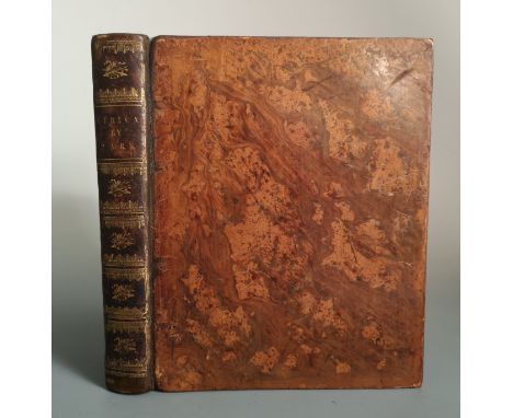
![Africae described, hand coloured map of Africa, for G. Humble, dated '1626' [but later?], 39 x 51cm (slight damage to lower l](https://cdn.globalauctionplatform.com/3183bdc5-fcf2-47e5-a3d1-ac540121db0c/84ff69f7-e2e6-4ed1-ab20-ac56010f89e2/468x382.jpg)


Lot 126
Map of Cambridgeshire, mid 18th century, foxing, 72 x 55cm; John Bodger, a plan printed on silk of Whittlesea Mere (damaged), 47 x 67cm; Jan Jansson, Map of the Fens, hand coloured engraving, foxing, 47 x 60cm; with a pen and watercolour map of Bedfordshire after Blaeu, dated 1909, 45 x 27cm (4)
Lot 157
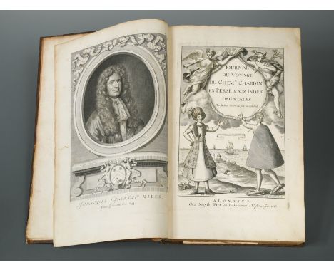
Journal du Voyage du Chevr. Chardin en Perse & Aux Indes Orientales. par la Mer Noire & par la Colchide. London: Moses Pitt 1686, folio, portrait frontispiece, engraved title, folding map and 15 plates (most folding), all as required, slight stain to lower corner of title and preface leaves, contemporary calf, spine ends chipped. Provenance: Heber Library copy with stamp


Lot 183
The Brighton and Lewes Guide, 1805, 12mo, folding coloured plate, lacking map, later half calf; Robin & Lindsay's Guide through Glasgow, no date, folding engraved map, printed paper wrapper; Historical Guide to Great Yarmouth, 1817, 2nd edition, small 8vo, original boards; An Account of the Corporation of Beccles Fen, 1826, 8vo, some added illustrations at the start, some staining, boards; PALMER (C J) A Booke of the Foundation and Antiquitye of Greate Yarmouthe, 1847, large stain to title and frontispiece shield, original cloth; and two small late 19th century souvenir cabinet albums of London landmark views (7)
Lot 198
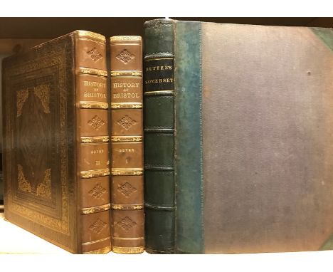
Memoirs Historical and Topographical of Bristol and its Neighbourhood, 2 vols., 1821-23, 4to, plates, light spotting and age staining, full morocco gilt with good reback; RUTTER (John) Delineations of the North Western Division of the County of Somerset. London 1829, 4to, with proofs on India paper, half-title, title and frontispiece plate slightly soiled, light foxing, untrimmed, half calf, with three further additional supplementary parts in original wrappers inserted; COXE (William) An Historical Tour in Monmouthshire, 2 vols., London 1801, 4to, folding map and plan, plates, general light age toning and spotting, rebacked calf gilt (5)

Lot 239
Collection of mainly 19th century works, including: BAILEY (T) Annals of Nottinghamshire, 2 vols. no date, thick 8vo, illustrated; [VASON (G)] An Authentic Narrative of Four Years' Residence at Tongataboo, 1810, 8vo, damaged frontispiece, map, very browned and stained; many others, mainly popular titles, novels and history (c.70 vol.)
Lot 248
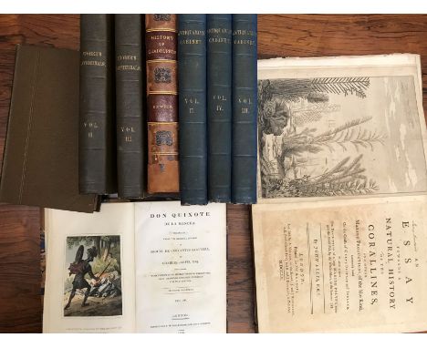
ELLIS (John) An Essay Towards a Natural History of the Corallines, and other Marine Productions...Commonly Found on the Coasts of Great Britain and Ireland, first edition, engraved frontispiece and 40 plates, some folding, foxing and browning, worming to foot of last 2 plates with slight loss of text, detached boards; URRY (John) The Works of Geoffrey Chaucer, 1721, folio, portrait (creased and frayed), illustrations, damaged detached binding; THOROTON (Robert). The Antiquities of Nottinghamshire, 1st edition, 1677, folio, double page map and plates, illustrations in the text, worn calf binding with replacement spine label; SPEED (John) The History of Great Britaine, third edition, 1650, folio, portrait frontispiece dust stained, double column text, illustrations, damaged detached binding; STORER (H) History and Antiquities of the Cathedral Churches of Gt Britain, in 4 vols., 1814-19, 8vo, illustrations, cloth; The Antiquarian and Topographical Cabinet, in 5 vols, 1817-18, 8vo, illustrations, some foxing, cloth; JARVIS (C) Don Quixote de la Mancha, in 4 vols, 1819, 8vo, coloured plates, damaged bindings; BEWICK (T) A General History of Quadrupeds, 3rd edition 1792, 8vo, later half calf, worn; and other mainly later general literature in varying condition
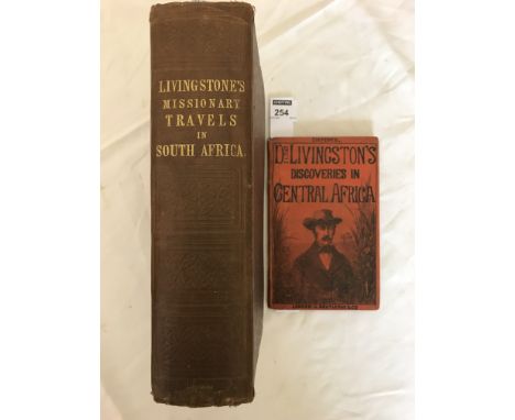
Lot 254
Missionary Travels and Researches in South Africa, first edition 1857, 8vo, folding frontispiece, geological plate, 2 folding maps, plates and illustrations as called for, portrait damp staining, slight foxing, original cloth; with a Routledge sixpenny edition of Livingstone's Discoveries, 1857, 12mo, 64pp, folding map, pictorial boards (2)


Lot 263
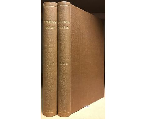
Journal of a Residence and Travels in Colombia, during the years 1823 and 1824, 2 volumes, first edition, 1825, 8vo, folding engraved map, two hand-coloured aquatint frontispieces, all with old ex. library stamps, with half title to vol. I, untrimmed, modern cloth; KOSTER (Henry) Travels in Brazil, 2nd edition, London 1817, 8vo, 9 plates and a plan as required, some foxing and staining, mainly to margins, untrimmed, ex. library stamps, modern cloth

Lot 270
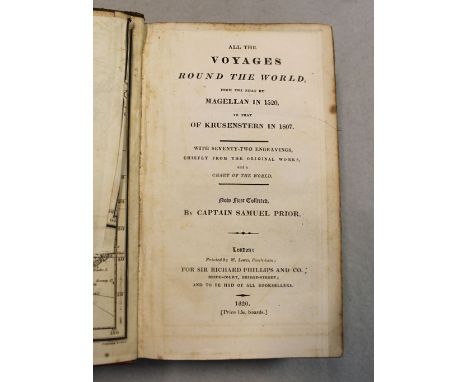
A Journey to Mequinez; The Residence of the Present Emperor of Fez and Morocco. London 1725, 8vo, six folding plates, subscribers list, occasional light spotting and general light age toning, recased and rebacked calf; PRIOR (Captain Samuel) All the Voyages Round the World. London 1820, 8vo, folding world map, engraved plates as required, ownership name to first end paper of 'Fras. Horatio Fitz Roy [1823-1900], Feb. 1st 1834', straight grain morocco (2)


Lot 273
A Brief Narrative of an Unsuccessful Attempt to reach Repulse Bay, London: John Murray 1825, 8vo, folding chart and 7 plates as called for, contemporary half calf; LAING (John) An Account of a Voyage to Spitzbergen. London 1815, 8vo, 159pp. title very slightly spotted, a little browning throughout, contemporary half calf; PENROSE, (Bernard) An Account of the Last Expedition to Port Egmont in Falkland's Islands, in the Year 1772. Together with the Transactions of the Company of the Penguin Shallop. London: for J. Johnson 1775, 8vo, rather toned, repaired tears to lower parts of several leaves with brown stain, early 20th century boards, armorial bookplate; EGEDE (Hans) A Description of Greenland, London 1745, 8vo, folding map, 11 plates, armorial bookplate of Stonor, calf, rubbed (4)
Lot 278
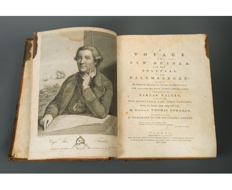
A Voyage to New Guinea and the Moluccas, London 1779, 4to, portrait frontispiece, folding map at the start, plates, maps and plans including folding as required, some a little creased and toned, ink stain to edge of upper fore-margin for first 30 leaves, contemporary calf with upper joint split, and spine chipped; GLAS (George) The History of the Discovery and Conquest of the Canary Islands. London 1764, 4to, folding map, 2 charts, calf, upper board detached (2)


Lot 308
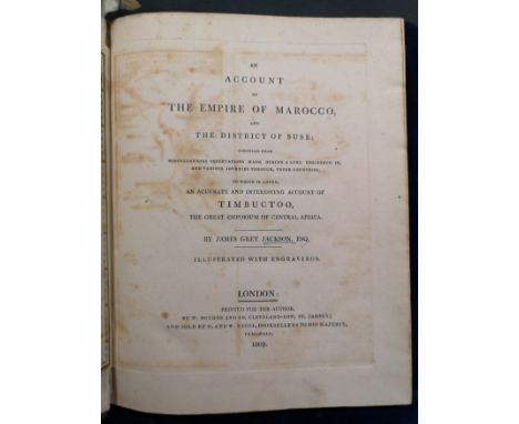
An account of the Empire of Marocco, and the district of Suse... to which is added an accurate and interesting account of Timbuctoo. London: for the author, 1809, 4to, 2 folding engraved maps, 11 plates (including 2 hand-coloured), with Addendum/errata leaf at end, occasional light foxing, some offsetting on to title from first map, tree calf with blind-stamped Garter arms to boards, rebacked


Lot 315
The Travels of Bertrandon de la Brocquiere, ... to Palestine and his return from Jerusalem overland to France during the years 1432 & 1433... translated by Thomas Johnes. Hafod Press, 1807, small 4to, half title, folding engraved map (loose), tomb illustration, recased in old boards, cloth spine;

Lot 320
Travels in Turkey, Asia-Minor, Syria and Egypt. London: for Richard Phillips 1803, 4to, folding engraved frontispiece, 20 plates (including many coloured), folding map, coloured plan, large folding firman or passport (linen backed with closed tear, some staining), taped tear to first free end paper, contemporary half calf, rubbed and worn

Lot 323
L'Ambassade de la Compagnie Orientale des Provinces Unies vers l'Empereur de la Chine, 2 parts in one vol., Amsterdam: Jacob de Meurs, 1665, title printed in red and black, additional engraved title, portrait, folding engraved map (slightly grey toned), 34 double-page engraved plates, engraved illustrations in text, very light scattered foxing, a few nicks to some outer margins, but generally a fine copy in contemporary mottled calf. Provenance: De Bourbon Library with red stamps, and a red Duc de Madrid stamp; Maggs acquisition label; Mark Dineley armorial bookplate.
Lot 328
Travels in Syria and the Holy Land. London: John Murray, 1822, first edition, 4to, half title, lithographed portrait frontispiece, 6 maps and plans (2 folding), illustrations in the text, some foxing and staining, occasional browning or offsetting to a leaf, recased in 20th century half morocco; Travels in Nubia, 2nd edition, 1822, 4to, engraved portrait and 3 maps, library stamp to head of title, foxing throughout, rebacked worn half calf; LIGHT (Henry) Travels in Egypt, Nubia, Holy Land, Mount Libanon and Cypress in the year 1814. London 1818, 4to, 20 plates including map and folding frontispiece, some variable damp staining and rippling to plates in places, title with marginal soiling, rebacked worn calf (3)
Lot 330
Personal Narrative of a Pilgrimage to El-Medinah and Meccah, First Edition in 3 vols., London 1855, 8vo, with vol. 3 half title as called for, errata leaf, 24 pp. publisher's catalogue at end of vols. I and III, 14 lithographic plates including coloured frontispieces, folding map, 3 plans, occasional light foxing and marginal toning, a very few library stamps to lower margins, original blue cloth with gilt lettered spines, residual glue marks of labels removed from foot of spines, a little bumped and worn, vol. II with vertical crease along spine (3)
Lot 331
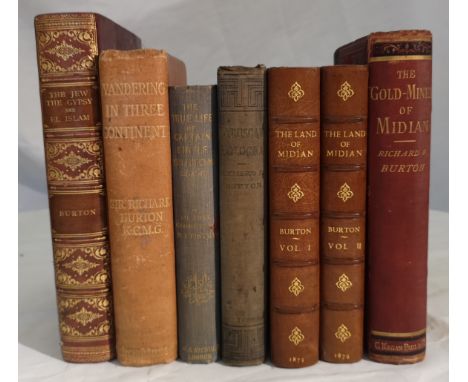
The Gold Mines of Midian, 1878, 8vo, first edition, half title, folding map, publisher's catalogue at end, some foxing (mainly to very first leaves and edges), original cloth worn in places, stain to one rear corner; The Land of Midian (Revisited), in 2 vols., 1879, 8vo, chromolithographic and other plates (some cropping), lacking half titles, a little dusty, half calf by Bayntun of Bath; The Jew The Gypsy and El Islam, 1898, 8vo, photogravure portrait, half calf gilt; Etruscan Bologna, 1876, 8vo, faded cloth; Wanderings in Three Continents, 1901, photogravure portrait, cloth with spine slightly faded; The True Life of Capt. Sir Richard Burton, 1896, cloth, faded stained spine (6)

Lot 334
Narrative of Travels in Northern Africa... accompanied by Geographical Notices of Soudan, and of the course of the Niger. London: John Murray 1821, 4to, with 17 hand coloured lithographed plates, folding map (some reinforcement and dust stains), general pale damp stain to lower margins throughout but not affecting actual images, top strip of title torn away and replaced without loss of text, full calf with some splitting and staining
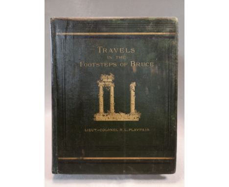
Lot 338
Travels in the Footsteps of Bruce in Algeria and Tunis. London 1877, 4to, plates, folding coloured map, rebacked original cloth; MORGAN (J) A Complete History of Algiers. London: J. Bettenham 1731, small 4to, partial brown stain to first few leaves including title, rather toned, contemporary calf; HARRIS (W B) The Land of an African Sultan, Travels in Morocco. London 1889, large 8o, mounted india paper plates, pictorial cloth;
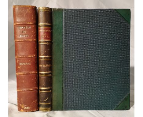
Lot 341
Constantinople in 1828. London: Saunders and Otley, 1829, 4to, with double-page view, 3 hand-coloured plates and one sepia plate of antiquities, half title, light spotting, endpapers foxed and discoloured, green half calf: SONNINI (C S) Travels in Upper and Lower Egypt, London 1800, 4to, folding map (loose), portrait and plates, soiling and staining to first leaves and plates, 20th century half morocco (2)
-
109182 item(s)/page