We found 109198 price guide item(s) matching your search
There are 109198 lots that match your search criteria. Subscribe now to get instant access to the full price guide service.
Click here to subscribe- List
- Grid
-
109198 item(s)/page


Lot 3209
Railway Related Paperwork GWR Penzance Car Menu dated Feb 3rd 1916; two Tickets and a Booklet for the Opening of the Heathrow Airport LU extension 1977; Ticket and Booklet for the opening of the Victoria Line 1969; together with a wartime German regional map Landshut with swastikas to top (all G-E)


Lot 144
D-Day Benham Coin official FDC PNC. 1994 cover C1 with full set D-Day stamps, Southampton Map postmark. Doubled with two USA D-Day stamps and USS Normandy CDS postmark. Has D-Day 50p coin inset. Good Condition. All signed items come with our certificate of authenticity. We combine postage on multiple winning lots and can ship worldwide. UK postage from £3.95, EU from £4.95, Overseas from £6.95.


Lot 2349
18th-century map of Nottinghamshire by Emanuel Bowen (c.1694-1767), hand-coloured copper engraving on laid/chain-lined paper. Decorative cartouche with dedication to Thomas Duke of Newcastle; engraved figures/animals top-left. Printed for T. Bowles & R. Sayer. Framed & glazed in Hogarth style frame.Condition Report: Very clean and bright for age.


Lot 2358A
Antique map of Irleand by Gerardus Mercator: 'Irlandiae Regnum'. Hand-coloured copper engraving on laid/chain-lined paper. 1595 or later. Vertical centre-fold as issued. Trimmed close to engraved border, mounted on laid paper with hand-painted ships. Framed. Together with c.1860 steel-engraved map depicting the department of Mayenne in the region of Pays de la Loire, by Victor Levasseur. (2)

Lot 2358
MAPS: A collection of eight county maps by Thomas Moule, 19th-century steel engravings, hand-coloured: Derbyshire, Devonshire, Leicestershire, Cumberland, Essex, Kent, Surrey, Staffordshire; together with a further map of Derbyshire from 'Lewis's Topographical Dictionary', an earlier 18th-century copper-engraved map of Nottingham on laid/chain-lined paper by E. Bowen, and an etching of Ashby-de-la-Zouch, Leicestershire. All framed & glazed. (11)


Lot 80
LOW GEORGE. A Tour Through the Islands of Orkney & Schetland. Frontis, illus. & fldg. & other maps. Orig. dec. brown cloth, wear to back. Kirkwall, 1879. Condition Report. LXXIV - Endpaper, half title, frontis, title, preface, contents, list of illustrations, introduction including plates. Folding map, small tear along fold. All illustrations / plates as called for. Generally slightly worn condition, wear to top and bottom of spine and corners of boards. Boards slightly bowed, splitting between front board and endpaper, rough fore edge with light foxing and sporadic foxing throughout. Some pages coming loose.

Lot 83
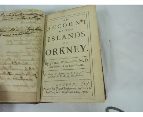
WALLACE JAMES. A Description of the Isles of Orkney. Ltd. ed. 4/250. Fldg. map & one fldg. plate. Orig. blue cloth, wear & rubbing to back. 1883 reprint of the 1693 ed.; also J. M. Macbeath, The Orkneys in Early Celtic Times, frontis & plates, orig. dark cloth, Kirkwall, 1892 & British Calendar Customs, vol. re. Orkney & Shetland, illus., orig. brown cloth, 1946. (3).
Lot 66
LOW GEORGE. Fauna Orcadensis or The Natural History of ... Orkney & Shetland. Quarto. Calf, crudely rebacked. Edinburgh, 1813; also Baikie & Heddle, Historia Naturalis Orcadensis, orig. limp cloth, Edinburgh, 1848 & Buckle & Harvie-Brown, A Vertebrate Fauna of the Orkney Islands, illus., orig. green cloth, Edinburgh, 1891. (3). Condition Report. Buckley and Harvie Brown - Map present. Worn / split and faded split, splitting between board and end paper. Browning / foxing to fore edge, especially on plates. Clean title and half title. Some light foxing throughout.Low - Splitting between board and endpapers. Title inscribed in pencil. Text generally good, some light browning and foxing, mainly to edges and front / back of text.Baikie and Heddle - Marked embossed wrapper, some splitting on bottom of spine. Title page inscribed and a bit marked. Some finger marks / foxing through text, also manuscript annotation in sepia ink "One shot by...." etc in margins.

Lot 81
CLOUSTON CHARLES. Guide to the Orkney Islands. Fldg. eng. map. Limp orig. cloth. A. & C. Black, 1862; also Daniel Gorrie, Summers & Winters in the Orkneys, frontis, orig. blue cloth, recased, 1868 & 3 others. (5). Condition Report. Re-backed with original boards and spine, no map. Some browning and foxing but readable copy.


Lot 111
A George III silkwork map sampler, embroidered with England and Wales, showing their respective counties and surrounding named bodies of water, the lower right with the north-west French coast, within a border of poppies, roses and further English flowers, monogrammed and dated 1817, oval, 58cm x 51cm
![Ordnance Survey of Ireland: Geological Survey of Ireland, Cushendall [County Antrim], Sheet 14, Engraved at the Ordnance Surv](https://cdn.globalauctionplatform.com/e71b8453-d5a5-4911-8785-a7ac010039d3/7029f244-9707-40a5-85d9-150764d882c6/468x382.jpg)
Lot 159
Ordnance Survey of Ireland: Geological Survey of Ireland, Cushendall [County Antrim], Sheet 14, Engraved at the Ordnance Survey Office, Dublin under the direction of Captain Wilkinson R.E., The Outline by Robert Mahony, the Writing by James Aikman, the Hills by John Duncan, Published by Colonel Sir H. James R.E., F.R.S., M.R.I.A. &c., Superintendent of the Ordnance Survey [...] 1886, four-fold map, hand-coloured engraving, 36cm x 54cm
![[Guthrie (William)], The Auftrian (sic), French and Dutch Netherlands, from the beft (sic) Authorities, Published by C: Dilly](https://cdn.globalauctionplatform.com/e71b8453-d5a5-4911-8785-a7ac010039d3/ad6e7404-ef54-4707-aa6b-2fea18acc7f9/468x382.jpg)
Lot 158
Ordnance Survey of England and Wales: Geological Survey of England and Wales, Sheet 92 N.E. (New Series Sheet 61) [part, North Yorkshire Moors], Engraved at the Ordnance Survey Office Southampton, The Outline by J. Adkins, the Writing by J.A. Harrison, The Hills by H. Dixon, Published by Colonel James R.E., F.R.S., M.R.I.A. &c., Superintendent [..] 1889, map, hand-coloured engraving, 37cm x 57cm
![Militaria - a WW2 ink MS and watercolour two-fold map, 144 Brigades Positions, Feb: 1940, Saar Front [Germany], 39cm x 26cm](https://cdn.globalauctionplatform.com/e71b8453-d5a5-4911-8785-a7ac010039d3/edeb6338-7ab5-4a05-b5ce-a15a99272033/468x382.jpg)
Lot 173
Militaria - a WW2 ink MS and watercolour two-fold map, 144 Brigades Positions, Feb: 1940, Saar Front [Germany], 39cm x 26cm Condition Report: Please see additional photographs, generally good condition, a couple of tears, creases and some foxing but clear and legible, appears to be just paper, no apparent backing, would be best to leave a commission bid or register online to bid, telephone lines are not available on this lot


Lot 51
Mauchline ware _ sewing _ seven pieces, comprising a wool bowl (Hexham Abbey and Shambles) 8.5cm dia, a thimble sauce pan (Stirling Castle, From Back Walk/Bought In The Douglas Roomƒ/Ye Towersƒ), 9cm, a darning mushroom (The Ancient Entrance Gate, Stirling Castle), 10cm, a cylinder box form pincushion (Peterborough Cathedral) 6.5cm, a needlebook (Thurso Castle From South), 9x6cm, a knitting needle cylinder (The Tower of London From Tower Hill/Manufactured abroad) 22cm, and a calendar and map paper knife 1898 (Eastern Telegraph Company), 34cm (7)

Lot 486
Maurice (Frederick). History of the War in South Africa, 1899-1902, volumes 1-4, plus 4 volumes of maps to volumes 1-4, 1906-10, numerous black and white maps, some light marks, uniform original gilt decorated blue cloth, boards and spines lightly rubbed, 8vo, together with Ewing (John), The Royal Scots 1914-1919, volume 1 only, 1st edition, 1925, numerous black and white illustrations, including folding map to rear, some minor toning, original blue cloth, boards lightly marked, 8vo, and other early 20th century and modern military reference and related, including publications by Airlife, Arms & Armour, P.S.L., Pen & Sword, mostly original cloth, many in dust jackets, some odd volumes, G/VG, 8vo/folio (6 shelves & a carton)

Lot 177
*World. Berry (William), A Mapp of all the World in two Hemispheres in which are exactly described all the parts of the Earth and Seas, Described by Sanson, Corrected and amended by William Berry, 1680, engraved map with contemporary hand colouring, some creasing, some dust soiling, repaired closed tears, torn with areas of loss and replaced in facsimile, 545 x 865 mm, mounted, framed and glazed R.W.Shirley. The Mapping of the World, no.501. Not examined out of frame. (1)
Lot 776
Betjeman (John). New Bats in Old Belfries, 1945; A Few Late Chrysanthemums, 1954; A Nip in the Air, 1974, 1st editions, original cloth, New Bats spine darkened, dust jackets, A Nip in the Air price-clipped, New Bats spine toned with small chips at ends, 8vo, together with Murray's Buckinghamshire Architectural Guide, 1st edition, 1948, folding map and half-tone illustrations, original cloth, price-clipped dust jacket, a couple of small closed tears and nicks, 4to, signed to title by John Betjeman, with five others including Church Poems, 1980 (the withdrawn first issue with the 'Bristol and Clifton' poem incomplete), and A Garland for the Laureate. Poems Presented to Sir John Betjeman on his 75th Birthday, Celandine Press, 1981, limited edition 83/350 (9)

Lot 47
Roger (Eugene). La Terre Saincte; ou Description Topographique tres-particuliere des saincts Lieux, & de la Terre de Promission. Avec un Traitté de quatorze nations de differente Religion qui l'habitent, leurs murs, croyance, ceremonies, & police. Un Discours des principaux poincts de l'Alcoran. L'histoire de la vie et mort de l'Emir Fechrreddin, prince des Drus. Et une Relation veritable de Zaga Christ Prince d'Ethyopie, qui mourut à Ruel prez Paris l'an 1638..., 1st edition, Paris: Antoine Bertier, 1646, folding engraved map of Palestine and thirty-six engraved illustrations to text (including 20 full-page illustrations of costume), old german blindstamps to few leaves, occasional scattered spotting, some dampstaining mostly to first few leaves, contemporary vellum, 4to Blackmer 1443; Atabey 1051; Tobler, p.100; Rouillard, p.255; Goldsmith R951. "Roger spent five years in Palestine. His work consists for the most part of a discussion of the 14 'nations' inhabiting the Holy Land together with a vituperative account of Islam. Rouillard gives 1644 as the date of the first edition but according to the privilege the work was first printed in 1646." (Blackmer). The source of the interesting plates is unknown. (1)
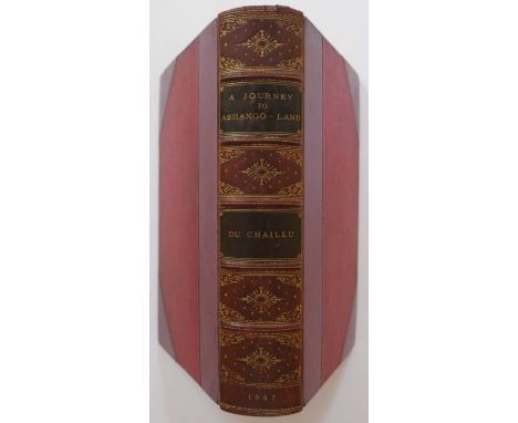
Lot 18
Du Chaillu (Paul B.). A Journey to Ashango-Land: and further penetration into Equatorial Africa, 1st edition, published John Murray, 1867, uncoloured engraved frontispiece and plates, folding map with some spotting, contemporary half calf with gilt decorated spine with contrasting morocco title labels, slight wear at head of spine, 8vo, together with Park (Mungo & Barrow John), Travels in the Interior of Africa by Mungo Park and in Southern Africa by John Barrow, interspersed with notes and observations, published A. Napier, Glasgow, 1815, frontispiece map of Park's route, frayed and worn with slight loss, backed with later linen, portrait of Park also backed with later linen, four engraved plates (including two folding) and a folding map of South Africa, all strengthened with linen, later endpapers, bookplate of William John Robertson,late 19th century half morocco gilt by Palmer Howe & Co. of Manchester, 8vo (2)
Lot 188
*Yorkshire. Saxton (Christopher), Eboracensis comitatus (cuius Incolae olim Brigantes appellabantur) Longitudine Latitudine hominumque nemero relequis illustrior, [1579], engraved map on two conjoined sheets, contemporary hand colouring and some later enhancement, old folds, some repaired and strengthened, long repaired closed tear affecting image, some marginal repaired closed tears, slight dust soiling, small sepia manuscript vignette added to the right of the mileage scale, one manuscript annotation to map, 535 x 730 mm, mounted, framed and glazed Not examined out of frame. (1)


Lot 19
Elphinstone (Mountstuart). An Account of the Kingdom of Caubul, and its Dependencies, in Persia, Tartary, and India, Comprising a View of the Afghaun Nation and a History of the Dooraunee Monarchy, 2 volumes, new and revised edition, 1839, hand-coloured aquatint frontispiece to each, large folding engraved map, uncoloured aquatint plate, some light spotting, armorial bookplates of Edward and Marianna Heron-Allen, original blindstamped cloth, spines a little faded with tiny tears at head, 8vo (2)

Lot 726
Essex House Press. Dante Map, by Mary Hensman, printed by The Guild of Handicraft, Essex House... from the drawing of John Williams and published by David Nutt, 1892, 2 folding hand-coloured lithographed maps, printed on one sheet (as published), 550 x 870 mm, signed with initials in black ink to lower right outer corner, with 51-page accompanying printed booklet, bound together in original cloth, a little rubbed and faded to spine and outer edges, 8vo (1)
-
109198 item(s)/page