We found 109198 price guide item(s) matching your search
There are 109198 lots that match your search criteria. Subscribe now to get instant access to the full price guide service.
Click here to subscribe- List
- Grid
-
109198 item(s)/page


Lot 1130
Maps. A collection of engraved antique maps of the British Isles, including: 1) Speed (John). The Isle of Man, London: Thomas Bassett and Richard Chiswell, [1676], 410 x 550 mm, hand-coloured, verso strengthened along central fold and with remnants of mounting-tabs along top edge, loose in map 2) Morden (Robert). The North Riding of Yorkshire, London: Abel Swale, Awnsham and John Churchill, c.1695, hand-coloured, 380 x 430 mm, mounted, 3) Ogilby (John). The Road from York to Whitby and Scarborough in Yorkshire, c.1700, 360 x 470 mm, laid down on tissue, mounted, 4) Pitts (J.). A New Map of Twenty Miles Round London, c.1750, 450 x 405 mm, 5) Bowen (Emanuel). An Accurate Map of the North Riding of York Shire, London: for John Bowles, Carington Bowles, Robt Sayer, c.1750, 560 x 730, toned, rolled in a tube, and 6 others similar in a folder with a small number of other prints (qty: 4 maps in mounts, 1 in tube, and a folder)


Lot 137
LOWTH GEORGE T. The Wanderer in Western France. Col. frontis, title & fldg. map. Orig. green cloth, some wear. Bookplate of Earl Fitzwilliam. 1863; also Captain Batty, French Scenery from drawings made in 1819, 56 (of 64) eng. plates, quarto, rebacked calf, 1822 & Voyage de Leurs Majestes L'Empereur et L'Imperatrice dans les Departements de L'Ouest, 1858. 66pp, plates & illus., folio in rebacked qtr. morocco. (3).

Lot 139
LLOYD GEORGE (Ed). Narrative of a Journey from Caunpoor to the Boorendo Pass in the Himalaya Mountains ... by Major Sir William Lloyd, & Captain Alexander Gerard's Account of an Attempt to Penetrate by Bekhur to Garoo & the Lake Manasarowara, with a letter from the late J. G. Gerard Esquire detailing a visit to the Shatool & Boorendo Passes. 2 vols. 3 linen backed eng. maps (two fldg.). Green morocco gilt, some rubbing & mkg., a.e.g. 1st ed., 1840; with a uniform vol. ed. by George Lloyd, Account of Koonawur in the Himalaya ... by the late Captain Alexander Gerard. Lacking map but with tables, 1st ed., 1841. Each vol. with a signed gift inscription from George Lloyd. (3).


Lot 189
A collection of various toys and games to include a boxed Dinky Supertoys 964 elevator loader, a scale model motorboat (incomplete), a bicycle cigar cutter, a diecast motorcycle, a stuffed parrot, a painted wooden puppet, a set of 3 map puzzles, a Chad Valley chess and draughts board, a J.W.S. & S. of Bavaria The Grand Race Game board, etc.
![Fine Binding.- Pope ([Alexander]). HOMER'S ILIAD 6 vol., woodcut frontispiece, folding engraved map and plates, bookplate of](https://cdn.globalauctionplatform.com/3d3e6aa2-8030-4c7d-a1ff-ad820105e6a7/86fcbc3f-5365-416d-ae83-ad8201179088/468x382.jpg)

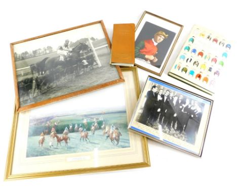
Lot 360
A collection of National Hunt horse racing memorabilia, etc., all relating to the jockey and latterly film stunt rider and trainer Tom Reeves to include a photograph of a farewell dinner to Steve Donoghue inscribed from his brother jockeys Piccadilly Hotel, 20th October 1937, present in the photograph are Tommy Weston, J Herbert, W Sibbert, Charlie Smirke, Steve Donoghue, Bernard Carslake, Michael Beary, Harry Wragg Joe Childs, Fred Fox and Gordon Richards, a photograph dedicated to Norma and Tom Reeves and dated 1988 from Harry Wragg, a black and white photograph, a print, a racecourse goer's map and guide and a Benson Hedges book of racing colours.


Lot 291
COLONEL JAMES ALEXANDER GRANTE (ACTIVE 1745-6) RARE JACOBITE MAP OF GREAT BRITAIN 1745-6, PUBLISHED engraving and etching, printed on paper, being a map of the routes, battles and sieges of the campaign of Prince Charles Edward Stuart in Great Britain, 1745-6 (Jacobite Rebellion (1745-6)), titled A CHART/ Wherein are mark’d all the different Routs of P. Edward in Great Britain, and the Marches of his Army, and the English. The Sieges are distinguish’d, and the Battles that were Fought in this Enterprise [process]/ This Chart with the Book will be very useful in History, the Dates of the principle Events, being marked with the greatest care and exactness./ More care has been taken in this Chart to mark out the motions of the Armies / than to make an exact Geographical Description of the Counties: An / old Map of Morden was our Model, as being proper for the Design. INSCRIB’D – to all –The HONEST(63.7cm x 41.5cm)Provenance: Property from Tornaveen House, AberdeenshireFootnote: Note: This map, a reduced version of a larger map held in the Royal Collection, was issued folded inside a ‘Book’ which is referred to in the title. The ‘Book’ is a small explanatory text entitled: ‘A / Description / of a / chart / wherein are marked out / All the different Routes / of / Prince Edward / in / Great Britain / and the Marches of his Army and the / E - gl - sh.’ According to Blaikie p.106, it was published in 1749. A description of the map and booklet is given in Shirley 1988, pp.63-4. Shirley records no variant states for this map which is thought to have been a proof and therefore very few copies would have been seen by the public. Copies of this map are held in the Royal Collection (RCIN 729135); and The National Archives, Kew (TNA MPF 1/2 extracted from SP 36/79.)


-
109198 item(s)/page