We found 109198 price guide item(s) matching your search
There are 109198 lots that match your search criteria. Subscribe now to get instant access to the full price guide service.
Click here to subscribe- List
- Grid
-
109198 item(s)/page


Lot 3599
Samuel Buck (1696-1779) and Nathaniel Buck (fl. 1724-1759), by and after, The East Prospect of Derby, 18th century strike, copperplate engraving with hand-colouring, 30cm x 80cm; English School (18th century), map, Derbyshire, Engrav'd for the Universal Magazine, Printed for T Hinton at the Kings Arms, St. Paul's Church Yard, London 1748, hand-coloured engraving, 22.5cm x 17cm; etc, [3]
![Speed (John), Huntington both Shire and Shire Town with the Ancient Citie of Ely Described, pub. George Humbell, [1616], hand](https://cdn.globalauctionplatform.com/fdf73c92-6ef6-49ab-9886-a90e00d34c85/326bc9af-2b0d-4117-9793-8945d82386e0/468x382.jpg)
Lot 3627
A New and correct Map of Leicester & Rutland, Engrav'd from an actual Survey, with other Improvements, Published by J. Harrison [...], London 1787, two-page, copperplate engraving, 42cm x 51cm; John Lodge Cowley (1719 - 1797), An Improved Map of Flint Shire (sic, Flintshire, Wales), containing the Boroughs and Market Towns with those adjoining; also its Principal Roads and Rovers, [probably printed by R. Dodlsey, at Tully's Head, Pall Mall, London c. 1740], engraving with hand-colouring, 16cm x 14cm, Liz Porter labels to recto and verso, [2]


![Joan Blaeu (1596 - 1673), by and after, two-fold map, Lewis and Harray (sic, [Harris, Outer Hebrides], from the Atlas of Scot](https://cdn.globalauctionplatform.com/fdf73c92-6ef6-49ab-9886-a90e00d34c85/da521af4-044c-44c2-c606-71aa24d6d23c/468x382.jpg)

Lot 3631
Jodocus Hondius (1563 - 1612) after John Speed (1552 - 1629), two-page map, The Countie (sic) of Nottingham, defscribed (sic) the Shire Townes (sics), Situation and the Earls there of obferved (sic), city plan and coats of arms to margins, the whole within a dogtooth border, copperplate engraving with hand-colouring, text to verso pages 65 - 66, [probably London 1676], 40cm x 53cm, Arnolds of Loughborough label to verso

![Robert Morden (c. 1650 - 1703), by and after, a two-page map, Herefordshire, [London c. 1753], hand-coloured engraving, 36.5c](https://cdn.globalauctionplatform.com/fdf73c92-6ef6-49ab-9886-a90e00d34c85/79ef592b-55b6-4440-a782-6524b81826e6/468x382.jpg)

Lot 3677
British Travel and Topography - Hakewill (James), The History of Windsor; and Its Neighbourhood, Edmund Lloyd, London 1813, full-page engraved plates, contemporary quarter-calf and marbled boards (boards loose and spine heavily rubbed), small folio; Seyer (The Revd. Samuel), Memoirs Historical and Topographical of Bristol and It's (sic) Neighbourhood, From the Earliest Period Down to the Present Time, Printed for the Author by John Matthew Gutch, Bristol 1821 - 1823, two-volume set, full-page architectural, topographical and antiquarian engravings, slightly later 19th century quarter-calf and marbled boards, large 4to; Walpoole (George Augustus), The New Britifh (sic) Traveller; Or, A Complete Modern Univerfal (sic) Difplay (sic) of Great-Britian and Ireland, Alexander Hogg, London 1784, lacks title-page, engraved allegorical frontispiece, fold-out map, full-page plates and some vignettes, contemporary calf spine (repaired), papered boards, 18th century and later MS ownership inscriptions, crown folio; Association Copy, The Harbours of England, Engraved by Thomas Lupton, from Original Drawings Made Expressly for the Work by J.M.W. Turner R.A., with Illustrative Text by J[ohn] Ruskin, E. Gambart and Co., London 1856, full-page steel engravings, blue buckram as issued (disbound), dedication inscription in MS ink to endpaper: From the Author's Father [...] With Kindest regards 30 Decr. 1857, crown folio, [5]
![British Travel and Topography - The British Tourist; or, Traveller's Instructive Guide through England and Wales [...], Print](https://cdn.globalauctionplatform.com/fdf73c92-6ef6-49ab-9886-a90e00d34c85/8fe7b462-f83b-4158-e6dc-a10acaa87717/468x382.jpg)
Lot 3679
British Travel and Topography - The British Tourist; or, Traveller's Instructive Guide through England and Wales [...], Printed and Published by R. Walwyn and Co., London [1821], pp: [iv], 162, three-fold hand-coloured copperplate engraved map of England to title-page, contemporary printed paper boards, 18mo; [Pratt (Samuel Jackson) New Forest in 1804, Richard Philips, London 1805], MS title-page and text incomplete, engraved frontispiece of the author by Caroline Watson after Sir Thomas Lawrence PRA, later 19th century binding incorporating later 19th century ephemera, 8vo; Warwickshire; Being a Concise Topographical Description of the Different Town and Villages in the County of Warwick [...], Embellished with Engravings, And an accurate Map of the County, John Aston, Coventry 1817, contemporary calf boards (disbound, spine defective), marbled endpapers, 8vo; An Illustrated Itinerary of the County of Cornwall, How and Parsons, London 1842, contemporary quarter-calf and buckram, 4to; A Description of Great Britain, [early-mid 18th century], lacking prelims and incomplete to verso, contemporary calf with double gilt fillet (disbound), 8vo, (faults); Robertson (William), Rochdale: Past and Present, A History and Guide, second edition, Schofield and Hoblyn, Rochdale 1876, chromolithographic illustrations, contemporary oxblood quarter-morocco and buckram, 16mo; Pughe (David William), Humphrey's Series: History of Beaumaris Castle and The Isle Anglesey & History of Caernarvon Castle and Town [...], bound as one, H. Humphreys, Carnarvon (sic) [n.d., c. 1830], contemporary buckram spine and marbled paper boards, 12mo; Diprose (John), Some Account of the Parish of Saint Clement Danes (Westminster): Past and Present [...], two-volume set, Diprose and Bateman, London 1868 - 1876, illustrated throughout, contemporary buckram boards, later 20th century spines, The Law Society: Library bookplates to each pastedown, further Law Society Library stamps, 8vo; A Survey of London by John Stow, Reprinted from the Text of 1603, With Introductions and Notes by Charles Lethbridge Kingsford, two-volume set, Clarendon Press, Oxford 1908, blue buckram as issued, 8vo; Hughson (David), London; Being An Accurate History and Description of the British Metropolis and Its Neighbourhood to Thirty Miles Extent, From an actual Perambulation, volume VI only, J. Stratford, London 1809, contemporary diced calf boards (disbound, spine with faults), 8vo; Old London, Papers Read at the London Congress, July, 1866, John Murray, London 1867, contemporary quarter-morocco an marbled boards, 8vo, [13]
Lot 3681
Camden (William), Britannia: or a Chorographical Defcription (sic) of Great Britain and Ireland, Together with the Adjacent Lands, Written in Latin [...] And Tranflated (sic) into Englifh (sic), with Additions and Improvements, Revifed (sic), Digefted (sic), and Publifhed (sic), with Large Additions by Edmund Gibson [...], second edition, two-volume set, Printed for James and John Knapton [...], London 1772, volume I: engraved portrait title-piece of the author in herald's tabard with coat of arms in a feigned oval by Robert White (1645 - 1703) and nine full-page engraved numismatic plates of coins, volume II: two-page engraved map Britannia Saxonica, further antiquarian line engravings illustrating text throughout each volume, 20th century olive quarter-calf and marbled paper boards, medium folios

Lot 3701
Leigh (Charles, Doctor of Phyfick (sic)), The Natural History of Lancafhire, Chefhire, and the Peak, in Derbyfhire (sic, Lancashire, Cheshire & Derbyshire): With an Account of the Britifh (sic), Phœnician, Armenian, Gr[eek] and Rom[an] Antiquities in those Parts, Printed for the Author [...], Oxford 1700, pp: First Book: [xxviii], 2 full-page plates of coats of arms, facsimile map, 164pp, errata leaf [i], 10 full-page engraved plates and one facsimile, [xxviii], author's vindication [ii], Second Book: 97pp, errata leaf [i], full-page plate, Third Book: 88 (complete but erroneous pagination to latter pages), postscript leaf [i], errata leaf [i], [30], 16 full-page plates, [2], [36], contemporary calf boards, 20th century in-keeping spine with gilt lettered label, crown folio
![Local Interest - Derbyshire - Glover (Stephen), The History, Gazetteer, and Directory of the County of Derby [...], edited by](https://cdn.globalauctionplatform.com/fdf73c92-6ef6-49ab-9886-a90e00d34c85/acd5875b-f04c-475a-89f2-778bf0b74b78/468x382.jpg)
Lot 3702
Local Interest - Derbyshire - Glover (Stephen), The History, Gazetteer, and Directory of the County of Derby [...], edited by Thomas Noble, Henry Mozley and Son, Derby 1829, 20th century black buckram, 8vo; Glover (Stephen), The Peak Guide [...], edited by Thomas Noble, Henry Mozley and Son, Derby 1830, contemporary buckram, front board with original printed paper title label, 8vo; Derby Illustrated: Its Art, Trade and Commerce, Robinson, Son & Pike, Publishers, London [c. 1890], early 20th century boards and spine, 4to; Chantrey's Peak Scenery; or Views in Derbyshire Engraved by W.B. and George Cooke After Drawings by Sir Francis L. Chantrey, R.A., With Historical and Topographical Descriptions by James Croston, F.S.A., Re-Issue edition, Stanesby & Co., London 1889, original boards (disbound, lettered spine strip detached but present), small folio; Pilkington (James), A View of the Present State of Derbyshire [...], two-volume set, J. Drewry, Derby 1789, 8vo, (disbound, faults); Bagshaw (Samuel), History, Gazetteer and Directory of Derbyshire, with the Town of Burton-upon-Trent [...], Printed for the Author, By William Saxton, Sheffield 1846, later 19th century full leather binding, marbled endpapers, 8vo; Adam (W.), The Gem of the Peak [...], fourth edition, Longman & Co., London 1845, fold-out map to title-page, full page sepia lithographs, contemporary grey buckram, 12mo; Croston (James), On Foot Through The Peak, or A Summer Saunter Among the Hills and Dales of Derbyshire, Whittaker & Co., London 1862, fold-put map of the county, green buckram as issued, 12mo; Memorials of Old Derbyushire, edited by Rev. J. Charles Cox, Bemrose and Sons Limited, London 1907; Hackett (Richard R.), Wirksworth and Five Miles Round: An Historical Sketch of the Principal Events of Interest Connected with the District, with Brief Notices of its Remarkable Personages, J. Buckley, Wirksworth [1899], floppy terracotta buckram, 12mo; Lock guides (3); Haddon Hall guide; Journal of the Derbyshire Archaeological and Natural History Society, Volume XVII, January 1895, 20th century blue buckram, Norwich Castle Museum book label; etc

Lot 3715
Morant (Philip), The History and Antiquities of the County of Essex, Compiled from the Best and Most Ancient Historians; From Domesday-Book, Inquisitiones (sic) post mortem, And other the most valuable Records and MSS. &c., The Whole digested, improved, perfected, and brought down to the present Time, two-volume set, T. Osborne [...], London & Meggy and Chalk, Chelmsford, 1816, volume I with fold-out hand-coloured engraved map of the county at title-page, later 19th century quarter-calf and buckram boards incorporating earlier elements, red leather title labels to spine, medium folios

Lot 3738
The Holy Bible, Containing The Old and New Testament and the New, Newly tranflated (sic) out of the originall (sic) tongues: and with the former tranflations (sic) diligently compared and revifed (sic), by his Majefties (sic) fpeciall (sic) command, Appointed to be read in Churches, Robert Barker, London 1634, prefixed with Speed (John), The Genealogies Recorded in the Sacred Scriptures, according to euery (sic) Family and Tribe, with the Line of Our Saviour Jesus Christ, Observed from Adam to the bleffed (sic) Virgin Mary [...], the latter with genealogical lines of descent and the two-page map of Canaan, later Apocrypha, Book of Common Prayer and Psalms, contemporary metal-mounted panelled calf over poplar boards, tacked vellum spine, thick 8vo, (incomplete, faults)
Lot 3743
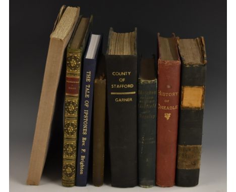
Topography - Anon, The Travels of Tom Thumb Over England and Wales; Containing Descriptions of whatever is moft (sic) remarkable in feveral (sic) Counties, Interspersed with Many pleafant (sic) Adventures that happened to him perfonally (sic) during the Courfe (sic) of his Journey, first edition, R. Amey, London 1746, pp: xii, 142pp, lacking fold-out map, contemporary sheep front board only (detached), conforming spine, 12mo; Erdeswick (Sampson, Esq), A Survey of Staffordshire: Containing the Antiquities of that County, Collated with Manuscript[s] [...] Illustrative of The History and Antiquities of that County by The Reverend Thomas Harwood, B.D., F.S.A., John Nichols and Son, Westminster 1820, engraved plates of antiquarian interest, contemporary marbled boards and later buckram spine, indistinct contemporary MS ownership inscription to title-page, 8vo; Garner (Robert, F.L.S.), The Natural History of the County of Stafford; Comprising Its Geology, Zoology, Botany, and Meteorology: Also its Antiquities, Topography, Manufactures, Etc., John van Voorst, London 1844, 20th century black buckram, 8vo; Plant (Robert, F.G.S.), History of Cheadle, in Staffordshire, And Neighbouring Places, With Chapters on Croxden Abbey [...] and the Cheadle Coalfield, William Clemesha, Leek 1881, red buckram as issued, contemporary armorial bookplate: Harry Vaughan Philips, 8vo; Williams (Alfred), Sketches In and Around Lichfield and Rugeley, Comprising A Descriptive & Historical Account [...], Eggington & Brown, Lichfield and H.J. Pascoe, Rugeley, 1892, contemporary buckram as issued, book label: Library of the Dominican Fathers, Haberstock Hill, London, 12mo; Nithsdale (W.H.), In the Highlands of Staffordshire: Being a Series of Rambles around Leek (Chiefly extracted from a young lady's journal, W.H. Eaton, Leek 1906, pictorial buckram as issued, 12mo; Yorkshire, Brighton (Rev. F.), The Tale of Ipstones, 1991 reprint, blue buckram, 8vo; Bogg (Edmund), A Thousand Miles in Wharfedale and the Basin of the Wharfe: Being a Description of a Tour by a Party of Artists Along its Banks and Tributaries from Cawood to Camfell, 1892, contemporary quarter-green morocco and buckram boards, gilt lettered title to spine, marbled endpapers, 8vo; Hall (T. Walter), The Fairbanks of Sheffield, 1688 to 1848, J.W. Northend Limited, Sheffield 1932, floppy card covers, 4to, [9]
Lot 3744
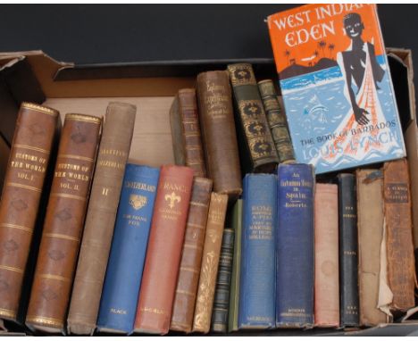
Travel - Scottish Provincial Imprint, A Voyage to the Pacific Ocean, Undertaken By Command of His Majefty (sic) for making Discoveries in the Northern Hemisphere, Performed under the direction of Captains Cook, Clerke and Gore In the Years 1776, 7, 8, 9 and 80, volume I only, R. Morison, Perth 1785, engraved portrait frontispiece of Captain Cook with further nautical vignette to frontis-page, pp: iv, 8, 346, [4], contemporary quarter-calf and marbled boards, red morocco title label gilt lettered to spine, 16mo; Conder (Josiah), A Popular Description of Peru and Chile: Geographical, Historical, and Topographical, James Duncan, London [n.d., c. 1829], pp: vi, [i], 360, one fold-out engraved map, 3 steel engravings, contemporary green quarter-morocco and marbled boards, the spine lettered in gilt, 18mo; Trollope (T. Adolphus), A Summer in Brittany, edited by Frances Trollope, two-volume set, Henry Colburn, London 1840, hand-coloured lithographic title-pieces, further monochrome lithographs, contemporary bindings (faults), Bound by W. Walker, Plymouth, labelled, Pictorial Armorial bookplates: Plymouth Public Library, 8vo; Conder (Joseph), Russia, James Duncan, London 1831, lacking map, contemporary quarter-green morocco and papered boards, 18mo; Jerrold (W. Blanchard), A Brage-Beaker with the Swedes: or, Notes from the North in 1852, Illustrated with Sketches by the Author, Nathaniel Cooke, London 1854, contemporary buckram, 12mo; Mockler-Ferryman (Major A.F.), In the Northman's Land: Travel, Sport, and Folk-Lore in the Hardanger Fjord and Fjeld, With Map, Illustrations, and Appendix, Sampson Low, Marston & Company, London 1896, contemporary maroon buckram, 12mo; Beattie (William, M.D.), Switzerland: Illustrated in a Series of Views Taken Expressly for this Work by W.H. Bartlett, Esq., volume II only, George Virtue, London 1839, full-page steel engravings, contemporary mauve buckram, 4to; Poesies and Scenery of Axenstein on the Lake of Lucerne, J.A. Preuss, Zurich [c. 1900], floppy green covers ,12mo; Fox (Sir Frank), Switzerland, second edition, A. & C. Black, Ltd., London 1930, 8vo; Home (Gordon), France, first edition, Adam and Charles Black, London 1914, 8vo; Moore (John), A View of Society and Manners in France, Switzerland and Germany [...], sixth edition, volume II only, A. Strahan and T. Cadell, London 1786, contemporary calf, the spine titled in contemporaneous ink MS, 8vo; Tuker (M.A.R.) and Malleson (Hope), Rome, Painted by Alberto Pisa, third edition, A & C Black Ltd., London 1925, contemporary blue buckram, 8vo; Roberts (The Rev. Richard, B.A.), An Autumn Tour in Spain in the Year 1859, Saunders, Otley, and Co., London 1860, full-page lithographs illustrating text, contemporary blue buckram, 8vo; Customs of the World, two-volume set, [lacking prelims but text complete], early 20th century, green quarter-morocco and buckram boards, ownership book stamp: Major H. Twyford, 4to, [18]
![Travel and Topography - Tombleson's Upper Rhine, Tombleson & Co., London [n.d., 1840], pp: [ii], viii, 181, indexes [iii], co](https://cdn.globalauctionplatform.com/fdf73c92-6ef6-49ab-9886-a90e00d34c85/58fd4f80-43bb-4dbd-a4a7-6aebb55b823c/468x382.jpg)
Lot 3745
Travel and Topography - Tombleson's Upper Rhine, Tombleson & Co., London [n.d., 1840], pp: [ii], viii, 181, indexes [iii], complete with full-page steel engravings and fold-out map to verso, contemporary quarter calf and mauve buckram boards, Plain Armorial bookplate on blue paper: Christopher Harrison, later ownership stamp, 8vo; Waterton (Charles), Wanderings in South America, The North-West of the United States, And the Antilles, In the Years 1812, 1816, 1820, & 1824, with Original Instructions for the Perfect Preservation of Birds, &c., For Cabinets of Natural History, second edition, B. Fellowes, London 1828, title-page and 2 prelims facsimile printings to complete original text, relayed contemporary calf, gilt double-fillet to boards, 20th century lettered red morocco title label, 8vo; Symonds (John Addington), Sketches and Studies in Italy and Greece, First Series, two-volume set, Smith, Elder, & Co., London 1898, contemporary maroon half-morocco and marbled paper boards, marbled endpapers, ink MS presentation inscription: To Esmé from H. Ponsonby FitzGerald, Nov: 1901, subsequent Golden Age Pictorial bookplate: Esmè Mary Parker to pastedown, 8vo, [4]
![Cotswolds Topography - Anon [Griffith (Samuel Young)], New Historical Description of Cheltenham And its Vicinity [...], Embel](https://cdn.globalauctionplatform.com/fdf73c92-6ef6-49ab-9886-a90e00d34c85/03eb5bc0-c10f-40b4-fa54-f24db67d5ae0/468x382.jpg)
Lot 3758
Cotswolds Topography - Anon [Griffith (Samuel Young)], New Historical Description of Cheltenham And its Vicinity [...], Embellished with Copperplate Engravings And Maps of the Town and Vicinity, From the latest Surveys, Also a Plan of Pittville, volume I only, S.Y. Grffith & Co., Cheltenham 1826, xii, 124pp, illustrated with full-page engraved plates and advertisements, pull-out map of the homonymous town, contemporary boards with traces of maroon morocco spine and angles (split), 8vo; Griffith (Samuel Young), New Historical Description of Cheltenham and Its Vicinity [...], Printed by S.Y. Griffith, Cheltenham [...], Published by Longman, Rees, Orme, Brown & Green, London 1826, xiv, 289pp, illustrated throughout with full-page engravings, contemporary printed boards (disbound), folio; the third edition, 1838, contemporary quarter-calf and green buckram boards (disbound), folio; Barnard (E.A.B.), Stanton and Snowshill, Gloucestershire, University Press, Cambridge 1927, h/b, d/j (torn), inserted printed presentation slip: With All Good Wishes for Christmas and the New Year from Sir Philip & Lady Stott, Stanton Court, Broadway, Worcs[estershire], 12mo; Gibbs (J. Arthur), A Cotswold Village: Or Country Life and Pursuits in Gloucestershire, sixth impression, third edition, John Murray, London 1909, 8vo, [5]
Lot 92
Album of Watercolours & Drawings. An album of various watercolours, drawings, engraved views and portraits compiled by a member of the Cookson family of Dorset, circa 1820-40, containing 32 various watercolours and drawings, mostly landscapes and portraits, and approximately 65 prints and engravings (the latter mostly etchings after Dutch Old Masters, views of historic buildings and churches including St. Cross Hospital, the Cathedral and the Denery at Winchester, Quorndon Church, Derbyshire, The Font at Bradford Abbas Church, Dorset, by the Reverend H. Turner, etc., and engraved portraits including George Lillingston, Lady Louth, Countess Cowper, Miss Marian Millicent Barton, Lady Hanmer, Lady Erskine and Lady Radstock), the watercolours include Tempio Antico, initialled FCC, a pen, ink and wash view of St. Peter's Tower, Dorchester, initialled to verso E.A.C., pencil portraits of Emma Fisher and Mrs Fisher, Close, Sarum, a pen, ink and brown wash study of the pulpit in St. Martin's Church, Salisbury, by Henry Wickens, dated 1838, an attractive landscape study of Windsor Castle in blue-grey wash over pencil on pale blue paper, etc. Provenance: Purchased at an unidentified auction on 10 February 1977, lot 170 (ticket inside) by Desmond Burgess, map and print dealer. This album appears to have been compiled by one of the Cooksons of Dorset, a prominent family which included Mary Cookson (born 1791), who married the reverend John Fisher (1788-1832), and lived in Osmington, Dorset. The Fishers became significantly close friends of the painter John Constable, who spent his honeymoon with his new wife Maria (nee Bicknell) there, and painted the Fishers' portraits in 1816. (1)


Lot 53
A Japanese map with extensive kanji and explicit Shunga scenes (possibly from a Yujo Hyoban-Ki), 37.5 x 27 cm; six small Shunga woodblock images; two Katsukawa style Shunga scenes; and a number of pages from woodblock ehon and other images (lot) For an explanation of Yujo hyoban-ki, compare the example of Yoshiwara Kagami (dated to about 1660) illustrated and discussed in 'The Dawn of The Floating World' Exhibition Catalogue (ISBN 1-903973-03-1). Please note that there are extensive areas of damage and deterioration to this lot.


Lot 291
Folio Society - King Henry's Map of the British Isles reproduced from Cotton MS Augustus I i 9, printed on Neobond by Beacon Press, Ucfield, for The Folio Society, limited edition of 2750 copies, in case; together with King Henry's Map of the British Isles commentary by Peter Barber, 2009 in slip case


Lot 1050
Set of three hand coloured engravings ' Geography Bewitched ', caricature maps of England, Ireland and Scotland, mounted, unframed, margins trimmed, together with a framed 19th Century map of Jamaica CONDITION REPORT Two have 0.25ins border with applied paper to enlarge borderOther has been trimmed with no margin on sides just a bit on top and the bottom, again re-mounted paper to edgesNone are stuck down to card but all repaired borders (see photo's)Map of Ireland has been trimmed to the plate mark.


Lot 259
An early Vulgate New Testament, missing titlepage, starting at page 3 with 'Sanctum Jesu Christi Evangelium Secundum Matthaeum Caput I...' and decorated capital 'L' (Liber generationis...), later-bound with a folding map of the Holy Lands (three maps in one) after Nicolas Sanson (1600-1667), the arms of Edward [9th] Duke of Norfolk, Earl Marshall of England (1686-1777) pasted down on inside front board (covering a previous ink inscription) and an engraving of Ezekiel and the Angel to inside back board, gilt-tooled calf, small 32mo


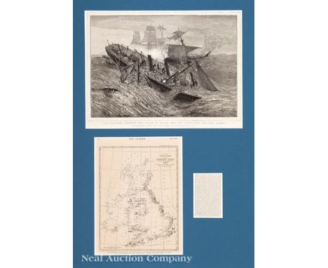
Lot 728
Three Nautical Prints, 19th c., incl. 2 of "The Ville du Havre", first by Currier & Ives, 1873, sight 10 1/4 in. x 13 1/4 in.; second possibly by Harper's Weekly, sight 13 3/4 in. x 18 in.; and "The East Indiaman", color lithograph, 8 in. x 13 in., each framed, second framed with a map and newspaper article. Provenance: Estate of Faith K. Tiberio, St. Augustine, FL

![[Plan of New York City], "Plan of the City of New York, Drawn from the Actual Survey by Casimir Goerck and Joseph Mangin, Cit](https://cdn.globalauctionplatform.com/3554f1f8-89cc-4c26-84e2-a90d012e2a82/3216adf4-9c5b-43b6-f1d5-8d42dacd462a/468x382.jpg)


Lot 188
1918 trench map of enemy rear organisation sheet 57A, a military cross, British War Medal and Victory Medal miniature trio and a bullet cross trench art with regimental sgt major's badge on chain with C of E Men's Society Condition Report Click here for further images, condition, auction times & delivery costs
-
109198 item(s)/page