We found 109198 price guide item(s) matching your search

Refine your search

Year

Filter by Price Range
  • List
  • Grid
  • 109198 item(s)
    /page

Lot 33

GREENWOOD C. & I. (Pubs). Map of the County of Cumberland. Large eng. map in rolled sections with fine "View of Carlisle", chipped & torn to edges, c.1820's (a.f.); also a rolled bundle of 19th cent. art school classical studies & various other items, documents, ephemera, etc.

Lot 49

(MAZUCHELLI ELIZABETH S.). The Indian Alps & How We Cross Them, by a Lady Pioneer. Fldg. map (small tear without loss), 10 col. litho plates & many vignettes. Small quarto. Rather worn orig. maroon cloth gilt, splitting internally at hinge, some internal spotting, mainly opposite plate pages. 1876; also 1969 reprint of Colonel Kirkpatrick's Account of the Kingdom of Nepaul, in orig. purple cloth & torn d.w. (2).

Lot 143

An architectural watercolour of the facade of a stone country house, by Hartshorne Architects, (apparently never built), 56 x 73cm; 'Broughton Hall' a faded watercolour architectural study, 25 x 36cm; "Carte du départment de L'Eure", hand-coloured pen and ink map by ''Legaud'', 1852, 56 x 83 cm (some loss and damaged); together with "Plan de Dieppe", engraving, 1786, (previously folded), 62 x 87 cm; and one other smaller town plan (5)

Lot 175

MEYRICK (Samuel Rush) The History and Antiquities of the County of Cardigan, London: T. Bensley, 1808, 4to, 20 engraved plates (one folding) as called for, slight offsetting on to title, a few sporadic fox marks, bookplate of Sir Robert Peel, contemporary full polished calf gilt, a crisp copy; JONES (Theophilus) A History of the County of Brecknock, 2 vol., Brecknock: for the Author, 1805, 4to, engraved vignette titles, 2 hand-coloured folding maps (small tears), 28 plates and 3 hand-coloured leaves of armorial shields, foxing/spotting to titles and plates, occasional dust staining to text, generally a little toned, half calf (rubbed); MALKIN (B. H.) The Scenery, Antiquities and Biography of South Wales, 1804, 4to, folding map, lithographic plates, rebacked calf (4)
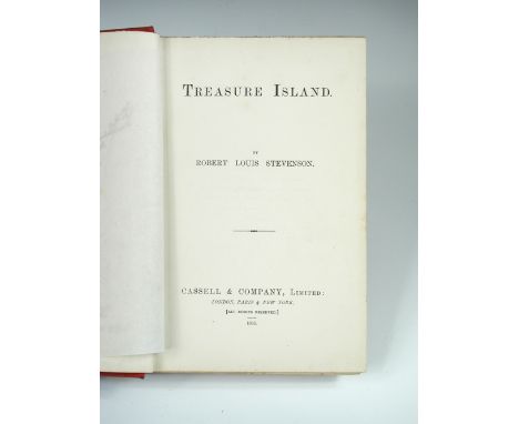
Lot 176

PEEL (William, Captain, R.N.) A Ride through the Nubian Desert, London 1852, 8vo, first edition, half title, map (slight dust staining), 32pp. catalogue at rear, original blue cloth, gilt lettered, armorial bookplate of Sir Mervyn Peel

Lot 244

STEVENSON (R L) Kidnapped, first edition 1887, 8vo, folding map frontispiece, light sporadic foxing, 17pp. catalogue at end dated 5G.4.86, original cloth spine strip bound in at end, full red morocco gilt by Bayntun Bath, a.e.g.;

Lot 303

YSTEVENSON (Robert Louis) Treasure Island, first edition Cassell & Co Ltd 1883, 8vo, an early issue, frontispiece treasure map, tissue guard, publisher's red cloth with gilt-lettered spine, spine slightly faded, boards slightly stained and cocked, 8pp adverts at end marked '5R-1083', slight foxing to contents leaves and p.1, fore edge spotted; with the following first issue points: "dead man's chest" not capitalised on pages 2 or 7; the first letter of "vain" is broken in the last line on page 40; the "a" is missing in line 6, page 63; the full-stop is not present after "opportunity" in line 20, page 178; "worse" for "worst" in line 3, page 197. Armorial bookplate of Sir Mervyn Peel, his signature and tipped in bookseller's catalogue slip, contemporary neat prize inscription dated March 1884 to half title.

Lot 34

Chapman and Andre Two large scale map sections of Essex, hand coloured engravings published 1777, plates VII and XVI, 47 x 57cm (plate size); C and J Greenwood Map of the County of Essex, hand coloured engraved map published 1831, with vignette of Audley End House to lower right, 60 x 70cm (3)

Lot 345

BARTLETT (W H) The Scenery and Antiquities of Ireland, 2 vols., London: G. Virtue no date c.1840, small 4to, added engraved titles, plates, and map, all with hand colouring, (portrait loosely inserted), recent half morocco

Lot 35

F. D. Soiron after Henry Bunbury A Pioneer, stipple engraving, 1791, 40 x 28cm; together with A map of Mexico and West Indies by C. Smith c.1800, 38 x 60cm (2)

Lot 350

BOYDELL (John and Joshua) An History of the River Thames, 2 vols. London: W. Bulmer, 1794-96, folio, complete with engraved frontispiece, double page map, 76 hand coloured aquatint views including 3 folding, occasional age staining, spotting and toning, in modern half calf binding

Lot 36

Island of Ceylon by Fullarton & Co, a hand coloured steel engraved map c.1860, plate XLII, from 'British Possessions in the Indian Seas', 45 x 31cm; and Thomas Kitchin, New Map of Indostan or East Indies, c.1780, hand coloured engraving, 35 x 39cm; and Cambridgeshire by Thomas Moule, and a small map of Asia by R. de Vaugondy (4)

Lot 37

Joan Blaeu Cantabrigiensis Comitatus Engraved hand coloured map of Cambridgeshire, slight dust staining and foxing, 50 x 58cm; and four prints including a drypoint seascape by Joseph Gray, 21 x 31cm (5)

Lot 373

LEAR (Edward) Journal of a Landscape Painter in Corsica, London: Robert John Bush 1870, engraved frontispiece and plates, map, original cloth (worn; inner hinges starting)

Lot 38

John Speed Hantshire described and devided hand coloured engraved map of Hampshire, published Bassett and Chiswell 1676, English text verso 39 x 52cm (15 x 20in)

Lot 383

SHEPHERD (G) The Picturesque Beauties of Great Britain - Kent, London: G. Virtue 1832, 4to, added vignette title, folding map, numerous engravings (two views per page), tissue guards, some spotting, modern half morocco

Lot 394

WRIGHT (G N) The Shores and Islands of the Mediterranean, Fisher, Son & Co, no date c.1840, 4to, added title, double page map, plates, occasional spotting, contemporary half calf gilt, slightly rubbed

Lot 409

BADESLADE (T) and John ARMSTRONG, The History of the Ancient and Present State of the Navigation of the Port of King's-Lyn and of Cambridge, illustrated with Maps, London: by J. Roberts for the Author 1725, folio, 7 maps and plates, a little toned and foxed; bound with 'A Scheme for Draining the Great Level of the Fens called Bedford-Level; and for Improving the Navigation of Lyn-Regis', 1729, 10pp, damp-stain to head, but without the map as called for on the title, later cloth bound.

Lot 410

BENNETT (J W) Ceylon and its Capabilities, London: W. H. Allen & Co., 1843, 4to, hand coloured map, 10 plates (most being coloured), some light dust staining, 2 of the uncoloured plates a little soiled, sewing weak with original cloth boards detached, damaged incomplete spine strip loose, contents loose in places

Lot 414

GIBBONS (A. St. H.), Exploration and Hunting in Central Africa, London: Methuen & Co 1898, 8vo, portrait, folding map, plates, 40pp publisher's catalogue dated December 1897 at end, slight foxing, mainly to outer margins and edges, original cloth gilt

Lot 417

MURRAY (HALLAM, A.H.) The High Road of Empire, John Murray 1905, 4to, illustrated, vellum backed cloth; HEAL (Sir Ambrose) Sign Boards of Old London Shops, 1947, cloth; BLEW (W C A) Brighton and its Coaches, London: Nimmo 1894, 8vo, coloured plates, grained half calf, marbled boards; Parham in Sussex, Batsford 1947, folio, no.93 of 250 copies on handmade paper for private circulation, half vellum; Excursions through Sussex, 1827, small 8vo, folding map, engravings, poor binding (5)

Lot 418

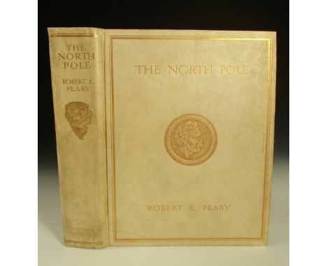
PEARY (Robert E.), The North Pole, London: Hodder and Stoughton, 1910, 1st edition, 4to, Edition de Luxe, numbered 66/500 and signed by Peary and Bartlett, presentation inscription to Edward H. Wood to first leaf, tipped-in photographic plates, folding map at end, original full vellum binding, a.e.g., gilt stamped on upper cover with embossed medallion, sporadic foxing

Lot 420

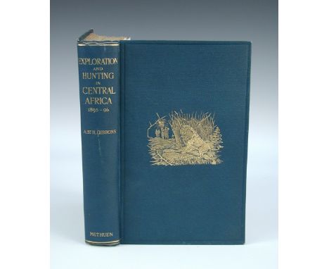
SELOUS (F C) Travel and Adventure in South-East Africa, London: Rowland Ward 1893, folding map, plates, original cloth; Sunshine and Storm in Rhodesia, London: Rowland Ward 1896, folding map, plates, original cloth (spine darkened); A Hunter's Wanderings in Africa, 3rd edition, London: Bentley 1893, folding map, plates, cloth gilt (3)

Lot 72

An amethyst and pearl bar brooch to a yellow metal setting together with a yellow metal bar brooch set with turquoise and a map of Australia and a cameo brooch

Lot 212

Britains neatly repainted or converted, some recast, Royal Engineers 5962 Pontoon Section (VG, one traces damaged), Limbered Wagon and others, with New Toy Soldiers Office Wagon, Map Table, Chairs, Officers etc. by Steadfast and others, with two Pontoons (VG, a few damaged) (58)

Lot 360

A Victorian map of Derbyshire including scenes of Chatsworth, another Edinburgh (2)

Lot 249

Books: Spinckes, N. The Sick Man Visited and Furnished with Instructions, Meditations and Prayers, etc, 1717, second edition, leather bound, 8vo; Bevan, Joseph Gurney, The Life of the Apostle Paul 1807 with folded map, leather bound 8vo; Tryals for High Treason and other Crimes with Proceedings on Bills of Attainder and Impeachments, part IV only 1720, lacks boards 8vo; Huxley, Thomas H, Man's Place in Nature and other Anthropological Essays Macmillian 1910, leather bound, and Anatomy by Henry Gray (Gray's Anatomy), Longmans, Green and Co 1883 (5)

Lot 487

6 Waddingtons Jig-Map jigsaws: Australia, South America, North America, New Zealand, India, and The British Isles.

Lot 219

A vintage 'Auto-Mapic' road map device of the UK together with a box of maps and travel guides.

Lot 337

A Robert Mordan framed & glazed coloured engraving of a map of Norfolk. Approx 38 x 59cm.

Lot 346

TWO BOXES OF COLLECTABLE AND CERAMICS, including Victorian travelling map, postcards, photograph frames, 19th and 20th Century tea and dinnerwares etc and two needlework pictures (4)

Lot 230

A QUANTITY OF ASSORTED COLOUR PRINTS AND NEEDLEWORK PICTURES, including cross stitch map of Staffordshire and Lilliput Lane interest (one box)

Lot 360

TWO BOXES OF PICTURES AND PRINTS, to include Staffordshire map, engravings, local scenes etc

Lot 399

Collection of mainly ornithological interest furnishing pictures, together with a reproduction framed map of Carmarthenshire. (8)

Lot 404

Captain Greville Collins, 'Milford Haven and the Islands', uncoloured original map. Framed and glazed.

Lot 559

A Wainwright map of Westmorland

Lot 560

Framed relief map of the lake district

Lot 665

Jacques-Nicholas Bellin - an 18th Century map of Bali, engraving with hand-colouring, 14 x 17.5cms; 5 1/2 x 6 3/4in.

Lot 798

Christopher Saxton and William Kip - "Dunelmensis" - a map of Durham, engraving with hand-colouring, 28 x 34.5cms; 11 x 13 5/8in; together with Pigot's engraved map of Durham, with hand-colouring and vignette of Durham Cathedral, unframed. (2)

Lot 247

A gilt framed antique map - Gloucester, together with an antique monochome print - HRH Prince console

Lot 434

'A NEW MAP OF TROPICAL-AMERICA NORTH OF THE EQUATOR', pub. by Dietrich Reimer, Berlin, 1858

Lot 442

T KITCHIN: A MAP OF CORNWALL and a framed Queen Victoria Golden Jubilee handkerchief (2)

Lot 538

After 'Samuel & Nathaniel Buck', 'South East Prospect of Bristol' C18th engraved map 'Brightstowe', latin text verso, C20th watercolour depicting Bristol & Hampshire map PLEASE always check condition before bidding or email condition report request.

Lot 252

Collection of prints and a map, (9)

Lot 278

After Edward John Poynter, study of a head, sanguine coloured print, 22cm x 17cm; a map of Leicestershire, print including John Wesley and other pictures.

Lot 285

Two antiquarian maps of Leicestershire, William Kipp and Christopher Saxon, a map of Leicestershire "Lecestriae Comitatus" circa 1637, plate number 24, 29cm x 36cm, Robert Morden a map of Leicestershire, circa 1695, 36cm x 42cm sold by Abel Swale Awnsham & John Churchill. (2)

Lot 1315

WILLIAM BORLASE. "Observations on the Ancient & Present State of the Islands of Scilly." 1st edn, folding map & other engr plates comp, well bound modern red morocco with map in gilt by the binder William Baxter, wide margins, 4to, 1756 vg copy.

Lot 1317

HEATH (ROBERT). "A Natural & Historical Account of the Islands of Scilly." folding map, table, engr view comp, cont calf, aeg, 8vo, 1750 vg.

Lot 1318

WOODLEY (GEORGE). "A View of the Present State of the Scilly Islands." hand col folding map, later 1/2 mor, teg, uncut, 8vo 1822 (copy once belonging to Capt S.D. Tiddy of steam packet Lyonnesse."

Lot 1380

PATERSON (DANIEL). "A New & Accurate Description of all the Direct & Principal Cross Roads in England & Wales." general engr map, 36 prelim & 394 pp comp, later leather backed bds, 12mo, 1794

Lot 1391

LIVINGSTONE (DAVID & CHARLES). "Narrative of an Expedition to the Zambesi & its Tributaries ... 1858 - 1864." 1st edn, illus & folding map comp, orig pict gilt cl, cat dated Jan 1865, thick 8vo 1865 good.

Lot 1434

BLACK (A. & C.). "Black's Guide to the South-Eastern Counties of England, Kent." 1st, map, plts & ads comp orig cl, 1862 good; plus quantity Baedeker & Murray hand books.

Lot 1445

STODDART (T.T.). "The Angler's Companion to The Rivers & Lochs of Scotland." plts & illus comp incl hand col plt of flies & map in pocket, orig cl gt, 1847 g

Lot 1500

LONDON ELECTRIC UNDERGROUND. "Reynold's Map of London..." good hand col engr map showing London Underground, 20 x 30 inches, 1902 linen-backed, folding, orig cl covers.

Lot 1510

MOTOR MAP OF CEYLON. "Survey Department Motor Map of Ceylon." col printed linen-backed map, 36 x 30 inches, dated 29 April 1922, good condition; plus 2 other items.

Lot 517

Miscellaneous including map of Cambridge, plastic vehicles, tin plate airplane etc.

Lot 1203

LE SAGE. "Le Sage's Historical, Genealogical, Chronological & Geographical Atlas." 38 hand col engr maps & charts comp, plus extra map of Europe, cont 1/2 mor, paper label, worn & det, folio, 1818 contents clean.

Lot 1204

LE SAGE. "Le Sage's Historical, Genealogical Chronological & Geographical Atlas." 38 hand col engr maps & charts comp, plus extra map of Europe, lacks covers, fl, 1818 clean.

Lot 1210

ANSON. "A Chart of the Channel in the Philipine Islands..." hand col engr map, 10.5 x 8.5 inches, framed, c1763 from the London 'Magazine'

Lot 1212

JOHN SPEEDE. engr map, "Breknoke, both Shyre & Towne described." inset of town shields, strapwork etc, 16.5 x 21.5 inches, f&g, Sudbury & Humble c1630 good.

Loading...Loading...
  • 109198 item(s)
    /page

Recently Viewed Lots