We found 109182 price guide item(s) matching your search
There are 109182 lots that match your search criteria. Subscribe now to get instant access to the full price guide service.
Click here to subscribe- List
- Grid
-
109182 item(s)/page

Lot 301
Reference (). A mixed collection of approximately ninety map reference books and facsimile atlases, 20th century, including reference works by Skelton, Beresiner, Booth, Potter and Black with several on Ordnance Survey maps, together with several facsimile atlases including Blaeu's 'Atlas Maior', plus a broken run of approximately fifty editions of 'Map Colletor's Circle', various sizes and condition (approx.140)
![Scotland. Ortelius (Abraham), Scotiae tabula, [1601 or later], hand coloured engraved map orientated to the west, 360 x 480 m](https://cdn.globalauctionplatform.com/8d62d9b7-eb09-46c4-bff7-a76300b144ad/41f54cbb-3df9-4885-edc7-47d4f22b14eb/468x382.jpg)
![*Shropshire & Staffordshire. Drayton (Michael), Untitled map, [1612 or later], hand coloured engraved allegorical map, 255 x](https://cdn.globalauctionplatform.com/8d62d9b7-eb09-46c4-bff7-a76300b144ad/9773b043-7043-465d-f7f2-26b0397f7024/468x382.jpg)


Lot 306
Sicily. De L'Isle (Guillaume), Carte de L'Isle et Royaume de Sicile, published Amsterdam by Jean Covens & Cornelius Mortier, circa 1735, engraved map with contemporary outline colouring, inset map of Malta and Gozo, 485 x 580 mm, together with Mercator (Gerard), Siciliae Regnum, circa 1610, hand coloured engraved map, toned overall with old tape staining to margins but not affecting image, 340 x 480 mm, French text on verso (2)

Lot 307
Sicily. Merian (Matthaus), Sicilia Regnum, published Nuremberg, circa 1640, hand coloured engraved map, very small rust hole on central fold, 270 x 350 mm, together with Ortelius (Abraham), Sicilia, circa 1605, uncoloured engraved map, some old tape staining to margins, 100 x 130 mm, with Mercator (Gerard & Hondius. H.),Sicilia, circa 1610, uncoloured engraved map, 150 x 185 mm, Latin text on verso, plus De Fer (Nicolaus),Isle et Royaume de Sicile, published Paris, circa 1705, engraved map with contemporary outline colouring, laid on larger sheet with descriptive text, slight staining, map size 230 x 340 mm, with two other maps of Sicily by Seale and Meyer (6)
Lot 308
Somerset. Schenk (G. & Valk P.), Somersettensis comitatus Somersetshire, circa 1720, engraved map with contemporary handcolouring, some oxidisation to old watercolour, slight staining, 375 x 500 mm, together with Morden (Robert),Somersetshire, [1695 or later], hand coloured engraved map, slight creasing, 360 x 420 mm, with Van den Keere (Pieter),Somersetshire, circa 1620, hand coloured engraved map, slight staining, 85 x 120 mm, English text on verso, plus another three county maps of with examples by Moule, Cary and Fullarton, various sizes and condition (6)
Lot 313
*Staffordshire. Jansson (Jan), Salopiensis comitatus cum Staffordiensi. Shropshire & Staffordshire, published Amsterdam, circa 1648, engraved map with contemporary outline colouring, 420 x 530 mm, mounted, framed and glazed, together with Blaeu (Johannes), Staffordiensis comitatus vulgo Stafford Shire, published Amsterdam, circa 1645, engraved map with contemporary outline colouring, slight overall toning, slight spotting, central fold a little stained, 415 x 505 mm, framed and glazed, with Saxton (Christopher & Kip William),Staffordiae comitatus pars olim Cornauiorum, circa 1637, hand coloured engraved map, some old tape staining to central fold, 275 x 380 mm, framed and glazed, plus Morden (Robert),Staffordshire, [1695 or later], hand coloured engraved map, 425 x 370 mm, mounted, framed and glazed, descriptive text fixed to rear of frame Not examined out of frames. (4)

Lot 316
Suffolk. Speed (John), Suffolke described and divided into Hundreds. The situation of the fayre towne Ipswich shewed, with the armes of the most noble families that have bene either Dukes or Earles both of that Countie as also of Clare, published Thomas Bassett & Richard Chiswell, [1676], uncoloured engraved map, inset town plan of Ipswich, short split at head and foot of central fold, 385 x 515 mm, English text on verso (1)

Lot 319
*Trinidad & Tobago. Van Keulen (Johannes), Pas kaart van Rio Oronoque met d'eylanden Trinidad, Tabago, Granada, Granadillos and Bequia..., published Amsterdam, circa 1683, engraved sea chart with contemporary outline colouring, inset map of the island of Tobago, compass rose and numerous rhumb lines, slight oxidisation of old watercolour, 520 x 590 mm, mounted, framed and glazed (1)
Lot 32
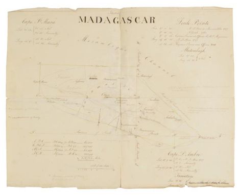
Madagascar. Voyages to Madagascar, also, A History Thereof, during the Reign of Radama and notes made on a voyage to the Island of Mombassa in HM Ships Phaeton and Andromache, 1817 and 1825, by Lieutenant T. Locke Lewis of the Royal Engineers, 1817-25, original manuscript in brown ink on laid paper, watermarked Yeeles & Medhurst, and dated 1813, 93 numbered pages, and large folded manuscript map of the Island (some fraying to edges, and repaired to central folds), folding manuscript plan of Tamatave Bay in pencil, plus an autograph letter acknowledging Lieutenant Lewis's manuscript and returning it to him, from Sir Robert Farquhar, Governor Mauritius, dated Reduit, 2 June 1821, and another autograph letter from Charles Telfair of Bois Cheri, Mauritius, dated May 21 1821, thanking Lieutenant Lewis for his permission to make extracts from his manuscript journal, both bound in at the front of the manuscript, contemporary red stiff paper boards, with handwritten title to upper cover, worn with some loss to spine, small 4to (23.5 x 18.5 cm) Thomas Locke Lewis Lieutenant (and later Captain) in the Royal Engineers married Anna Maria Peile in 1830 and died at Ibsley, near Exeter on 17th November 1852. This important manuscript account of Madagascar was published in edited form in the Journal of the Royal Geographical Society for 1835, pages 230-242. The account provides detailed information on the Ovah people of Madagascar, the reign of King Radama, local customs, economy and language, and includes an alphabet of the Ovah language written by Lewis on board HMS Phaeton dated 3rd July 1817. Charles Telfair (1778-1833) was an Irish botanist, who established botanical gardens in Mauritius and Reunion, following his return to the Island in 1816, having previously visited the Island as a ship's surgeon in the Royal Navy. He was also Vice President of the Literary and Scientific Society of Mauritius. (1)
![Wales. Blaeu (Johannes), Wallia Principatus vulgo Wales, published Amsterdam, [1645 or later], engraved map with contemporary](https://cdn.globalauctionplatform.com/8d62d9b7-eb09-46c4-bff7-a76300b144ad/b3b3d8f2-87b1-4ee9-8b25-2c905ffa98bc/468x382.jpg)
Lot 321
Wales. Blaeu (Johannes), Wallia Principatus vulgo Wales, published Amsterdam, [1645 or later], engraved map with contemporary hand colouring, decorative cartouche, slight spotting largely confined to margins, slight text show through, 390 x 505 mm, Latin text on verso John Booth. Antique Maps of Wales, no.14. (1)
![Wales. Ortelius (Abraham), Cambriae typus auctore Humfredo Lhuydo, Denbigiense Cambrobritano, [1598], hand coloured engraved](https://cdn.globalauctionplatform.com/8d62d9b7-eb09-46c4-bff7-a76300b144ad/64e3eded-d083-4c3b-c985-6d9024c31f8f/468x382.jpg)
Lot 324
Wiltshire. Saxton (Christopher & Kip William), Wiltoniae comitatus herbida planicie nobilis vulgo Will Shire pars olim Belgarum, [1610], hand coloured engraved map, 280 x 355 mm, together with Blome (Richard),A Mapp of Wiltshire with its Hundreds, circa 1673, hand coloured engraved map, old folds, closed tear to lower right corner, repaired on verso, 326 x 260 mm, with Morden (Robert),Wiltshire, circa 1701, hand coloured engraved map, 225 x 175 mm, plus Gibson (John),Wiltshire, [1759 or later], hand coloured engraved map, 110 x 65 mm, with four other county maps of Wiltshire by John Cary, John Aiken, Emanuel Bowen and Thomas Moule (8)

Lot 325
World. Bajo la Zarpa Brit nica breve historia del militarismo Ingl‚s, circa 1915, large colour printed map showing the British Empire coloured in red with the member states linked by chains, a Spanish anti-British map propoganda map (the title translates as 'In the British Claw', old folds, slight spotting and creasing, 780 x 1090 mm, together with Was Frankreich von Deutschland geraubt hat, und was es noch rauben will!, published Berlin, circa 1918,colour printed poster with three inset maps of Europe showing the territory lost and gained by the German empire in 1547, 1786 and 1812, torn with slight loss to printed surface in lower right and left corners, replaced in facsimile, 460 x 580 mm (2)
![World. Magini (Giovanni), Universi Orbis Descriptio, Venice [1596 or later], hand coloured engraved map, after Abraham Orteli](https://cdn.globalauctionplatform.com/8d62d9b7-eb09-46c4-bff7-a76300b144ad/c2c1e064-fd77-49b4-a67d-355d55391753/468x382.jpg)
Lot 327
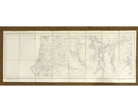
Yorkshire. Ordnance Survey (publishers), First edition of the '1 inch' series, sheet numbers 85, 93, 94, 95, 96 & 104, together with sheets 91, 92, 97, 98, 99 & 101, published in the 1840s and 1850's but this is the 1865 electrotype form, together twelve large uncoloured maps, sectionalised and laid on linen, each sheet approximately 635 x 950 mm, marbled endpapers, contained in two contemporary cloth slip cases with dust caps and printed paper labels to spines, together with Stockdale (John), Untitled map sheet of part of the East Riding of Yorkshire, 1809, one (of twenty) large uncoloured engraved sheets that made up Stockdale's large scale map of Yorkshire, 615 x 700 mm, plus a collection of thirty-one 'Old Ordnance Survey Maps' of Yorkshire and its surroundings from 'The Godfrey Edition' and the reprint edition of the one-inch series, late 20th century, various sizes, with four other facsimile Yorkshire Ordnance survey maps, all in good or very good condition (38)

Lot 328
Yorkshire. Speed (John), The West Ridinge of Yorkeshyre with the most famous and fayre Citie Yorke described, published Roger Rea, circa 1662, hand coloured engraved map, inset town plan of York, some marginal closed tears central fold frayed with closed tears, repaired and strengthened on verso, slight dust soiling and offsetting, 385 x 510 mm, English text on verso (1)

Lot 329
Yorkshire. Saxton (Christopher & Lea Philip), York-Shire described by Ch. Saxton. Many additions and corrections as ye Roads, Wapontakes &c. by. P. Lea, published George Willdey, circa 1730, engraved map with contemporary outline colouring on two conjoined sheets, old folds, margins and some folds strengthened and repaired on verso, cancelled library stamp to verso, 530 x 730 mm Originally published in Willdey's 'The Shires of England & Wales'. (1)
Lot 330
Yorkshire. Greenwood (C. & J.), Map of the West Riding of York from an actual survey made in the years 1817 & 1818, Map of the North Riding of the County of York from an actual survey made in the years 1817 & 1818 [and] Map of the East Riding of the County of York, from an actual survey made in the years 1831 & 1832, published 1834, three large maps engraved by J. & C. Walker, contemporary hand colouring, slight offsetting, each approximately 630 x 765 mm (3)

Lot 36
O'Reilly (Bernard). Greenland, the Adjacent Seas, and the North-West Passage to the Pacific Ocean, Illustrated in a Voyage to Davis's Strait, During the Summer of 1817, 1st edition, printed for Baldwin, Cradock, and Joy, 1818, engraved map frontispiece and two folding maps, eighteen engraved and aquatint plates (some offset to text), publisher's advertisement leaf at rear, scattered spotting and some water-staining, hinges repaired, untrimmed, modern quarter calf over contemporary boards, covers somewhat rubbed and soiled, and edges a little worn, 4to Abbey, Travel, 633. (1)

Lot 39
Said-Ruete (Rudolph). Said bin Sultan (1791-1856), Ruler of Oman and Zanzibar, His Place in the History of Arabia and East Africa, 1st edition, 1929, black and white plates, folding map, some spotting, author's signed presentation inscription to front free endpaper, dated at London, 30 May 1934, 'To Countess Cave of Richmond in remembrance of her association with Zanzibar as a token of esteem and sympathy given by the author', original cloth gilt, slightly rubbed and a few minor marks, 8vo Rare signed presentation copy of this biography of Said bin Sultan written by his grandson. (1)
Lot 44
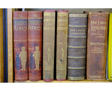
Stanley (Henry M.). In Darkest Africa or the Quest, Rescue and Retreat of Emin Governor of Equatoria, 2 volumes, 1st edition, 1890, two folding maps (with short closed tears), wood engraved illustrations, a few minor spots, original red pictorial cloth gilt, 8vo, together with The Last Journals of David Livingstone, in Central Africa, from 1865 to his Death. Continued as a Narrative of his Last Moments and Sufferings, obtained from his faithful servants Chuma and Susi, by Horace Waller, 2 volumes, 1st edition, 1874, portrait frontispiece to volume I, two folding maps (one contained in volume I rear pocket), wood engravings, publisher's list at end, a few scattered spots, endpapers renewed, original cloth, recased with most of original cloth relaid, some fading and stains, 8vo, with H.M. Stanley's How I Found Livingstone, 1872 (two copies, one first edition rebound with defective map, the other 2nd edition) (6)
Lot 53
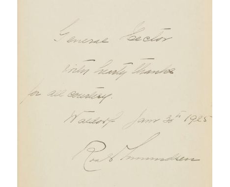
Amundsen (Roald). The South Pole. An Account of the Norwegian Antarctic Expedition in the "Fram," 1910-1912, Translated from the Norwegian by A.G. Chater, 2 volumes in one, London: John Murray; & New York: Lee Keedick, 1925, photographic portrait frontispiece and ten plates, one full-page map, charts & diagrams to text, front free endpaper inscribed by Amundsen "General Hector with hearty thanks for all courtesy, Waldorf Jan. 30th 1925", some toning throughout (mostly to margins), original blue cloth gilt in bright condition, 8vo Spence 21. In the Autumn of 1924 Amundsen travelled to the United States to recoup his fortunes by lecturing and writing for various newspapers. Whilst in New York he stayed at the Waldorf-Astoria. (1)


Lot 55
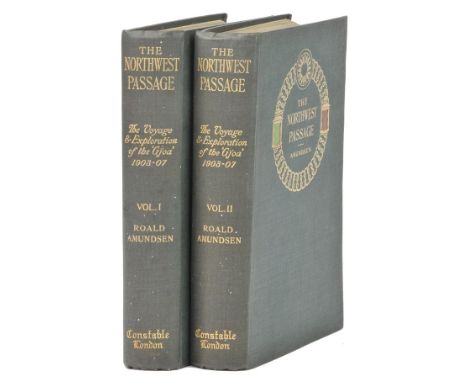
Amundsen (Roald). The North West Passage. Being the Record of a Voyage of Exploration of the Ship "Gjoa" 1903-1907, 1st English edition, 2 volumes, 1908, portrait frontispiece to volume I, folding colour map at end of each volume, half-tone illustrations, top edge gilt, original green cloth gilt, very small indentation to volume I upper board, 8vo Bright copy. (2)

Lot 576
Dibdin (Thomas Frognall). A Bibliographical Antiquarian and Picturesque Tour in the Northern Counties of England and in Scotland, 2 volumes bound in 4, 1838, extra-illustrated with engraved views and plates, some spotting, modern half calf with contrasting leather spine labels, large 8vo, together with Roscoe (Thomas), Wanderings and Excursions in North [& South] Wales, 2 volumes, circa 1840, each with 50 engraved plates including additional titles, folding map to each, some heavy spotting, inner hinges cracked, contemporary red half morocco gilt, rubbed, 8vo, plus Rose (Thomas), Westmorland, Cumberland, Durham & Northumberland Illustrated..., 1838, 70 engraved views, mostly two to a page, some spotting, contemporary half morocco, rubbed, spine torn at head, 4to, plus other 19th and 20th-century travel and topography (3 shelves)

Lot 59
Back (Sir George). Narrative of the Arctic Land Expedition to the Mouth of the Great Fish River, and along the Shores of the Arctic Ocean in the Years 1833, 1834 and 1835, 1st edition, 1836, 16 uncoloured engraved and lithographed plates, folding map (repair to verso), a few plates close-trimmed shaving imprint, some light spotting, bookplate, contemporary burgundy morocco, edges a little rubbed, 8vo, together with Narrative of an Expedition in H.M.S. Terror, undertaken with a view to Geographical Discovery on the Arctic Shores in the Years 1636-7, 1st edition, 1838, 12 uncoloured lithographed plates, folding map (reinforced to verso), small marginal tear and loss to p. 329, scattered spotting, endpapers renewed, contemporary half calf, rebacked, a little rubbed, 8vo Sabin 2613 and 2617 respectively. (2)

Lot 60
Barrington (Daines). The Possibility of Approaching the North Pole Asserted, A New Edition, with an Appendix, containing papers on the same subject, and on a North West Passage, by Colonel Beaufoy, printed for T. and J. Allmann, 1818, half-title present, folding engraved map frontispiece of the North Pole, title with wood engraved vignette showing men hunting a bear on pack ice, some pale spotting to preliminary leaves (generally in clean condition), contemporary half calf gilt, with gilt motifs of a sailing ship and falcon to spine, rubbed and a small loss to head and foot of spine, 8vo Sabin 3629. (1)

Lot 61
Barrow (John). A Chronological History of Voyages into the Arctic Regions; Undertaken chiefly for the purpose of Discovering a North-East, North-West, or Polar Passage between the Atlantic and Pacific: From the Earliest Periods of Scandinavian Navigation, to the Departure of the Recent Expeditions under the Orders of Captains Ross and Buchan, 1st edition, 1818, folding engraved map (partial light offsetting), three letterpress engravings at end, bound without half title, a little light spotting, contemporary calf, head of spine chipped with loss, joints cracking, 8vo (1)
Lot 62
Beechey (Frederick William). A Voyage of Discovery towards the North Pole, performed in His Majesty's Ships Dorothea and Trent, under the command of Captain Buchan, R.N.,; 1818; to which is added, a summary of all the early attempts to reach the Pacific by way of the Pole, 1st edition, Richard Bentley, 1843, half-title present, folding lithographed map, 6 full-page plates, including 2 folding lithographed panoramas, spotting to first and last few leaves and to single-page plates, one or two short closed tears to the folding panoramas, without loss, presentation inscription in ink to verso of front endpaper 'Second Prize presented to John Hanbury by the Worshipful Company of Brewers as a Reward for General Proficiency in the Sixth Class. Xmas 1860', signed by the headmaster, contemporary gilt-decorated full calf, with gilt coat of arms of the Brewers Company School in Islington, London, rubbed and some marks and waterstaining to covers, minor fraying to head of spine, 8vo Hill (2004) 97. Sabin 4349. An attempt by Captain Buchan and Sir John Franklin to reach the Bering Strait via the North Pole, in which Beechey was Lieutenant. The second part refers to earlier attempts made by Barents, Hudson, Baffin, Tschitschagoff and Phipps. (1)

Lot 64
Bragg (Benjamin, pseudonym). A Voyage to the North Pole, Accompanied by his Friend Captain Slapperwhack; with An Account of the Dangers and Accidents they experienced in the Frozen Seas of the Polar Circle. Also, the Manner of their Wintering on the Island of Spitzberg, and Discovery of the Polar Continent, 1st edition, 1817, half-title, engraved frontispiece and folding map at rear, browning throughout and occasional spotting, late 19th/early 20th century quarter morocco gilt, light wear to extremities, 12mo (1)
Lot 65
Chappell (Lieut. Edward). Narrative of a Voyage to Hudson's Bay in His Majesty's Ship Rosamond, Containing some Account of the North-Eastern Coast of America and of the Tribes Inhabiting that Remote Region, 1st edition, 1817, folding engraved map, four engraved plates, some offsetting and spotting, top edge gilt, later green half morocco, spine a little rubbed at ends, 8vo, together with Narrative of the Discoveries on the North Coast of America; Effected by the Officers of the Hudson's Bay Company During the Years 1836-39, by Thomas Simpson, 1st edition, 1843, lacking maps, a few spots, bindstamp to title, bookplate, contemporary half calf, spine faded with small burnholes, 8vo, plus Arctic Explorations: The Second Grinnell Expedition in search of Sir John Franklin, 1853, '54, '55, by Elisha Kent Kane, 2 volumes, Philadelphia & London, 1856, steel-engraved portrait frontispieces, additional titles, 18 plates, three maps, wood engraved illustrations, some light spotting, endpapers renewed, later green half morocco, original gilt spines relaid, a little rubbed with small chips to spine labels, 8vo, with two others (6)

Lot 66
Chappell (Lieut. Edward). Narrative of a Voyage to Hudson's Bay in His Majesty's Ship Rosamond, Containing some Account of the North-Eastern Coast of America and of the Tribes Inhabiting that Remote Region, 1st edition, J. Mawman, 1817, folding engraved map frontispiece (ink stain to margin at head, spotted), four engraved plates and few wood engravings to text, ink ownership stamp to title, scattered spotting and some offsetting to text, hinges repaired, late 19th century black half sheep, extremities slightly rubbed, 8vo Sabin 12005. (1)

Lot 70
Dennett (John Frederick). The Voyages and Travels of Captains Ross, Parry, Franklin and Mr. Belzoni, 1835, additional engraved title, letterpress title bound after p. 540, 11 engraved plates and portraits, some spotting and waterstains, modern calf-backed boards, 8vo, together with The Last Voyage of Capt. Sir John Ross, to the Arctic Regions, for the Discovery of a North-West Passage; Performed in the Years 1829-30-31-32 and 33. To which is prefixed an Abridgement of the Former Voyages of Captns. Ross, Parry & Other Celebrated Navigators to the Northern Lattitudes..., by Robert Huish, 1836, engraved portrait frontispiece, additional title, map and six plates, letterpress title detaching, light spotting, contemporary half calf, a little rubbed, 8vo, with three others: Robert Huish's Narrative of the Voyages and Travels of Captain Beechey... and of Captain Back..., 1836 (lacking portrait of Beechey), John Barrow Junior's A Visit to Iceland, 1835 and An Auto-Biographical Memoir of Sir John Barrow, 1847 (5)

Lot 72
Fisher (Alexander). A Journal of a Voyage of Discovery to the Arctic Regions, in His Majesty's Ships Hecla and Griper, in the Years 1819 & 1820, 1st edition, 1821, two engraved maps (one folding), illustrations, bound without half title?, red ink stamp to title and page 185, scattered spootting, armorial bookplate of Castle Kelly, contemporary half calf, rebacked, a little rubbed, 8vo, together with A Brief Narrative of an Unsuccessful Attempt to reach Repulse Bay, through Sir Thomas Rowe's "Welcome," in His Majesty's Ship Griper, in the Year MDCCCXXIV, by Captain G.F. Lyon, 1st edition, 1825, folding engraved chart (linen-backed), seven engraved plates, some spotting and soiling, contemporary calf, upper cover detached, some wear to spine, 8vo, with four others: Thomas M'Keevor's A Voyage to Hudson's Bay, During the Summer of 1812, 1819 (lacking one plate), Chevalier de la Poix de Freminville's Voyage to the North Pole, in the Frigate Syrene..., 1819 and Letters Written During the Late Voyage of Discovery in the Western Arctic Sea, by an Officer of the Expedition, 1821 (lacking the map and three plates), all three published by Sir Richard Phillips and part of his 'Voyages and Travels' publications, circa 1819-1824 and The Dangerous Voyage of Capt. Thomas James, in his Intended Discovery of a North-West Passage into the South Sea, 2nd edition, 1740 (lacking map) (6)
Lot 74
Franklin (Sir John). Narrative of a Journey to the Shores of the Polar Sea, in the years 1819-20-21-22, 2 volumes, 2nd edition, John Murray, 1824, 4 folding engraved maps, including one with outline hand-colouring, occasional very light marginal spotting, pale waterstain to lower outer corners, at front of first volume, untrimmed, original boards with printed spine labels, a little rubbed and some marks, rebacked retaining original spines, 8vo Sabin 25625. Arctic Bibliography 5195. First published in 1823 and an immediate success, Franklin's first polar expedition, also known as the Coppermine Expedition, was the first of his three attempts to discover and map the Northwest Passage. Disorganised and poorly planned, the party of 20 men had been reduced to 9 by starvation and suspected murder amongst the group, before they were rescued by native tribesmen. As a result of the public interest and appreciation of Franklin's heroic efforts on the expedition, he became known as 'the man who ate his boots'. (2)
Lot 75
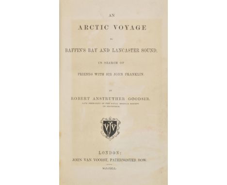
Goodsir (Robert Anstruther). An Arctic Voyage to Baffin's Bay and Lancaster Sound, in Search of Friends with Sir John Franklin, 1st edition, John Van Voorst, 1850, half-title inscribed 'To Mr Robert Macadam from the author', tinted lithograph frontispiece, folding map, 8pp. publisher's adverts at rear, removed oval ink stamp to title and adhesive stain to final advert leaf, dust & finger soiling, some spotting & marks throughout, endpapers renewed, original cloth gilt, neatly rebacked preserving original spine and corners repaired, 8vo Sabin 27931. One of the scarcer titles relating to the Franklin rescue efforts. The volume consists of extracts from a journal kept in 1849. (1)
Lot 78
Hooper (William Hulme). Ten Months among the Tents of the Tuski, with Incidents of an Arctic Boat Expedition in search of Sir John Franklin, as far as the Mackenzie River, and Cape Bathurst, 1st edition, 1853, four tinted lithogtraphed plates, two uncoloured plates, folding map at end, bound without half title, light spotting front and rear, presentation inscription, all edges gilt, contemporary green morocco gilt, edges a little rubbed, 8vo, together with Journal of a Voyage in Baffin's Bay and Barrow Straits, in the Years 1850-1851, Performed by H.M. Ships "Lady Franklin" and "Sophia," under the command of Mr. William Penny, in search of the Missing Crews of H.M. Ships Erebus and Terror, by Peter C. Sutherland, 2 volumes, 1st edition, 1852, six lithographed plates (including four colour), two folding maps (both supplied in facsimile), library and previous owner stamps, later half calf, spines a little faded, 8vo, plus A History of Shipwrecks and Disasters at Sea, from the most Authentic Sources, 2 volumes, Constable's Micellany of Original and Selected Publications volumes LXXVIII & LXXIX, 1833, additional engraved titles, wood engravings, a few spots, contemporary half calf, rebacked, 12mo, with other polar related including a couple of odd volumes (10)
Lot 82
Kane (Elisha Kent). Arctic Explorations: The Second Grinnell Expedition in Search of Sir John Franklin, 1853, '54, '55, 2 volumes, first edition, Philadelphia & London, 1856, engraved portrait frontispiece and additional engraved title to each volume, eighteen engraved plates, two folding maps & one single-page map, numerous wood engraved illustrations to text, titles with contemporary ownership inscription of Conway Shipley with his bookplate to upper pastedowns, some scattered spotting, 19th century tan half calf, gilt decorated spines (browned), extremities rubbed, 8vo, together with Kane (Elisha Kent), The United States Grinnell Expedition in Search of Sir John Franklin. A Personal Narrative, new edition, New York & Philadelphia, 1857, engraved portrait frontispiece, folding map and five plates, numerous wood engraved illustrations to text, scattered spotting throughout, verso of front free endpaper inscribed "Conway M. Shipley Esqr. with Lady Franklin's kind regards, New York, Oct 23. 1860", with Conway Shipley's bookplate to upper pastedown, 19th century tan half morocco, gilt decorated spine (near matching other volumes in lot), extremities rubbed and scuffed, dampstain at foot of spine, 8vo Sabin 37001 (first title). Each volume with book label 'De la Bibliotheque du Comte de Chambord (Henri V de France, duc de Bordeaux) N‚ en 1820, Acquise par Magg Bros. Ltd. de Londres' to upper pastedowns. Conway Shipley served as artist on board the Bulldog expedition of Sir Leopold McClintcock in 1860. The expedition was to survey for the purpose of a cable between Europe and North America. Lady Franklin inscribed the volume while in New York during a North American tour. (3)
Lot 85
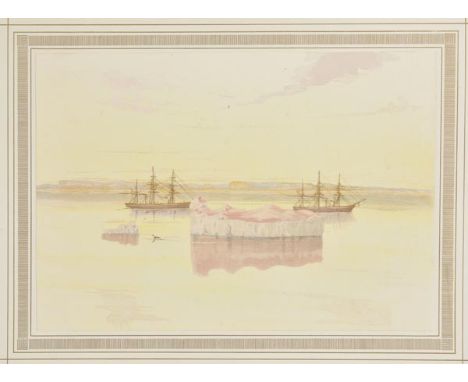
Moss (Edward L.). Shores of the Polar Sea. A Narrative of the Arctic Expedition of 1875-6, 1st edition, 1878, colour map, 16 mounted chromolithographed plates, illustrations, a few light spots, hinges tender, all edges gilt, original blue decorative cloth gilt, spine with small tears at end, some edge wear, folio Edward Moss served as surgeon aboard the flagship Alert, on the 1875-76 Nares British Arctic expedition and also as artist with the plates 'from Drawings made on the spot by the author'. (1)
Lot 89
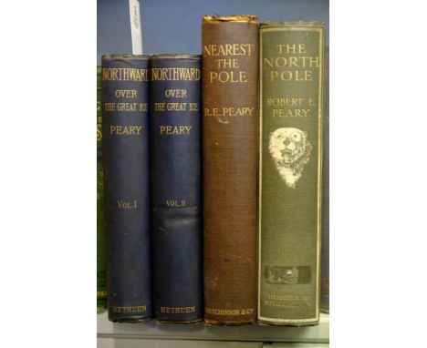
Peary (Robert E.). Northward Over the "Great Ice". A Narrative of Life and Work along the Shores and upon the Interior Ice-Cap of Northern Greenland in the Years 1886 and 1891-1897, 2 volumes, 1st English edition, 1898, portrait frontispieces, folding map at end of volume II, maps and illustrations, endpapers a little toned, top edge gilt, original blue cloth, upper covers with small vignettes blocked in silver, one or two corners a little bumped, 8vo, together with Nearest the Pole. A Narrative of the Polar Expedition of the Peary Arctic Club in the S.S. Roosevelt, 1905-1906, 1st English edition, 1907, two folding maps, illustrations (frontispiece detaching), light toning to endpapers, original cloth gilt, head of spine chipped, light dampstains to lower cover, large 8vo, plus Peary's North Pole, 1st English edition, 1910 (4)
Lot 90
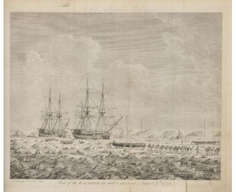
Phipps (Constantine John). A Voyage Towards the North Pole undertaken by His Majesty's Command 1773, 1st edition, printed by W. Bowyer and J. Nichols, for J. Nourse, 1774, half-title present, folding engraving map frontispiece, with closed tear repaired, now linen-backed, 14 engraved plates and maps, mostly folding, 11 folding letterpress tables, some marks and soiling, several plates linen-backed, Halifax circulating library bookplates to front pastedown, contemporary half calf, rubbed and some wear, modern reback, with outer corners renewed, 4to Hill 1351. Sabin 62572. In 1773, Phipps was appointed Commander of an expedition to discover whether the Arctic Ocean might be free of ice in the open sea, and in consequence provide a route to the Pacific. His expedition proved otherwise, although his detailed scientific reports provided highly useful information, including the first European description of the polar bear and the ivory gull. On board the Carcass was a young midshipman by the name of Horatio Nelson. (1)
Lot 94
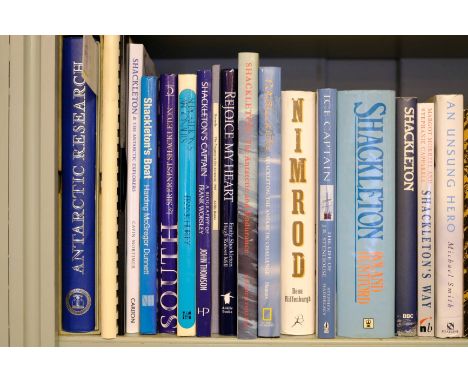
Priestley (Sir Raymond & Raymond J. Adie). Antarctic Research. A Review of British Scientific Achievement in Antarctica, 1st edition, 1964, numerous colour and monochrome illustrations, some light spotting, original cloth, separate map portfolio, slipcase (some fading and stains), 4to, together with The Antarctic Chef. The Story of the Life of Charles Green, the cook on Sir Ernest Shackleton's Expeditions to Antarctica on the 'Endurance' in 1914 and the 'Quest' in 1921, compiled by his nephew Roy Cockram, 1999, illustrations, original ring binder with author presentation inscription, with other polar, mainly Shackleton-related including Roland Hunter's Shackleton, 1985 and South. The Story of Shackleton's Last Expedition 1914-17, edited by Peter King, 1991 edition (30)
Lot 95
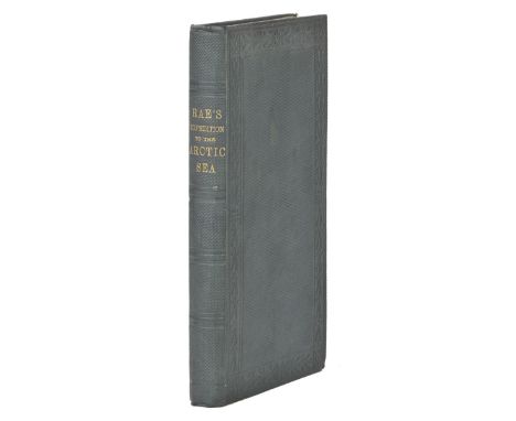
Rae (John). Narrative of an Expedition to the Shores of the Arctic Sea in 1846 and 1847, 1st edition, 1850, bound without the two maps and advertisements at end, title with clear tape repair to verso, marginal offsetting to title, light toning at end, front endpaper with blindstamp and piece torn away at head, original blindstamped green cloth, one or two small faint stains, 8vo Arctic Bibliography 14097; Sabin 67428. Provenance: Charles Murray Adamson, his signature to title, and a 2 pp. autograph letter signed by John Rae and dated 1876, to Adamson, recalling their conversation about natural history and not being able to accept a dinner invitation at the present time (a little toned). Rae's 1846-7 Expedition was commissioned by the Hudson's Bay Company to map and explore the arctic coast of Canada from Repulse Bay to Simpson's easternmost point, and established that Boothia Felix was a peninsula and not an island. Pencil note at front states that the Staton & Tremane copy also lacks the maps and 'we know of 2 other copies which also lacks them. It would appear that some copies were published without them'. (1)

Lot 97
Ross (John). A Voyage of Discovery, made under the Orders of the Admiralty, in His Majesty's Ships Isabella and Alexander, for the Purpose of Exploring Baffin's Bay, and Inquiring into the Probability of a North-West Passage, 1st edition, John Murray, 1819, folding engraved map frontispiece and 31 engraved, etched & aquatint plates, panoramas, charts and maps, including several folding and several hand-coloured (includes engraved "Explanation" leaf with observational chart), few engraved diagrams and illustrations to text, errata slip present, occasional spotting, offsetting and dampstaining to few leaves, hinges repaired, contemporary marbled boards with modern half calf, gilt decorated spine, 4to Abbey Travel 634; Sabin 73376; Books on Ice 2.5.; Pilling 3386. "Ross's expedition had some notable achievements including the confirmation of William Baffin's description of Baffin's Bay exactly two hundred years earlier ... His encounter with a previously unknown group of native people whom he referred to as 'Arctic Highlanders' was memorably drawn by Sackheuse and known through its reproduction in Ross's volume ... In effect Ross began a new era in Arctic research" - Books on Ice. Includes a "Comparative List of the Northern and Southern Eskimaux Language," as well as a list of "Words the Same in Both Dialects" (pages 122-23). (1)


-
109182 item(s)/page