We found 109182 price guide item(s) matching your search

Refine your search

Year

Filter by Price Range
  • List
  • Grid
  • 109182 item(s)
    /page

Lot 2059

Assorted volumes to include:- Igulden, Conn  "Bones of the Hills", 2008, dust wrapper not price clipped Beno, Ritchie "The New Champions, Australians in the West Indies 1965" Tooleys Maps and Map Makers Warhol, Andy "25 Cats ...", 2 vols within a slip case, illustrations, printed from the original which was initially privately published in the 1950's The Wisden Papers 1888-1946 and 1947-1968, various copies of Wisden to include 2003, 1998, 2005 and other Wisden related volumes and a quantity of books relating to art and antiquities to include:- Parissien, Steven "Regency Style", "Adams Style", "Palladian Style", "The Swedish Room" and various other volumes (3 boxes)  

Lot 2114

Assorted pictures and prints to include a watercolour of citrus fruits by Ross Floyd, a shadow play dragon, a watercolour on parchment of a Chinese-style jar, a map of Rutlandshire, etc (19) 

Lot 25

1960 Greeves Scottish Registration Number: YYW 476 Frame number 1791  Engine Number 2225H291F1329   The name Greeves is famous for competition machines in the 60s and 70s. The company was founded by Bert Greeves, producing a range of road and later competition bikes. Their trademark was cast beam downtube and rubber-in-torsion leading link forks, proved adaptable to almost all forms of motorcycles from the humble commuter to clubmans road racer, but it was the firm's off road products which really put Greeves on the map. The off-road range was extensively revised for 1958, gaining new frames with increased ground clearance, together with a narrower rear subframe and swinging arm. This 1960 model, fitted with the famous Villiers starmaker engine, has been with our vendor for over 20 years, and is described as in good running condition. Road registered, with current V5c, this would make the ideal motorcycle for classic trials events.

Lot 22

Historische Kupferstichkarten Belgien, Frankreich und Elsass, 17. und 18. Jhd. 'Belgii Universi seu Inferioris Germaniae quam XVII Povinciae' von J.B. Homann 1747, Maße ca. 55 x 50 cm. 'Carte de France dessée pa Guillaume de l'Isle et accomodée par les Heritiers d'Homann, Regni Galliae seu Franciae Navarrae Tabula Geographica' von J.B. Homann 1741, Maße ca. 53 x 62, beide Karten an der Mittelfalz gerissen, Löcher, Flecken, Ränder angerissen, handkoloriert. Außerdem 'Schlestat une des villes imperiales d'Alsace' aus dem Mercator Hondius 1635, Maße ca. 28 x 23 Ausgeschnittene Karte, unkoloriert, Mittelfalz.| Historical copper engraved maps Belgium, France and Alsace, 17. and 18. c. 'Belgii Universi seu Inferioris Germaniae quam XVII Povinciae' by J.B. Homann 1747, dimensions approx. 55 x 50 cm. 'Carte de France dessée pa Guillaume de l'Isle et accomodée par les Heritiers d'Homann, Regni Galliae seu Franciae Navarrae Tabula Geographica' by J.B. Homann 1741, dimensions ca. 53 x 62, both maps torn at centerfold, holes, stains, edges torn, hand colored. Except the 'Schlestat une des villes imperiales d'Alsace' from the Mercator Hondius 1635, measures ca. 28 x 23 Cut out map, uncolored, centerfold.

Lot 21

Historische Karten Italien und Spanien 17. Jhd.- Kupferstichkarte 'Territorio di Pavia, Lodi, Novarra, Tortona, Alessandria et altri vicini dello Stato di Milano' von Willem Blaeu 1662, Maße ca. 50 x 39 cm, Mittelfalz, an Rändern gerissen, Flecken, handkoloriert, Text auf Rückseite. Außerdem eine Holzschnittkarte 'Von Hispanien' kleiner Ausschnitt einer Seite von Sebastian Münster 1628, Maße ca. 23 x 14 cm, Buchseite (obere Hälfte, untere fehlt), in Papprahmen, Altersspuren.| Historical maps of Italy and Spain 17th c., Copper engraved map 'Territorio di Pavia, Lodi, Novarra, Tortona, Alessandria et altri vicini dello Stato di Milano' by Willem Blaeu 1662, dimensions approx. 50 x 39 cm, centerfold, torn at edges, stains, hand colored, text on reverse. Besides the one woodcut map 'Of Hispania' small section of a page by Sebastian Münster 1628, dimensions approx 23 x 14 cm, book page (upper half, lower missing), in cardboard frame, signs of age.

Lot 14

Vier Kupferstichkarten der Regionen Sachsen, Niedersachsen und Berlin, 18. Jhd. davon 1 x 'Middlemarck' Berlin, von J. Gibson 1760, ca. 26 x 21 cm, 1 x ' A New and accurate Map of the North East part of Germany' mit Schlesien, Sachsen und Brandenburg von Emanuel Bowen 1756, ca. 37 x 27 cm, 1 x ' A New and accurate Map of the North East part of Germany' mit Mecklenburg, Pommern und Brandenburg von Emanuel Bowen 1756, ca. 35 x 35 cm, 1 x ' A New and accurate Map of the North West part of Germany' mit Westfalen und Niedersachsen von Emanuel Bowen 1756 im Papprahmen. Mit Rissen und Knicken, teilweise kleine Löcher, Altersspuren, Handkoloriert.| Four copper engraved maps of the regions of Saxony, Lower Saxony and Berlin, 18. c., of which 1 x 'Middlemarck' Berlin, by J. Gibson 1760, ca. 26 x 21 cm, 1 x ' A New and accurate Map of the North East part of Germany' with Silesia, Saxony and Brandenburg by Emanuel Bowen 1756, ca. 37 x 27 cm, 1 x ' A New and accurate Map of the North East part of Germany' with Mecklenburg, Pomerania and Brandenburg by Emanuel Bowen 1756, ca. 35 x 35 cm, 1 x ' A New and accurate Map of the North West part of Germany' with Westphalia and Lower Saxony by Emanuel Bowen 1756 in cardboard frame. With tears and creases, some small holes, signs of age, hand colored.

Lot 12

Zwei alte Fliegerkarten vermutlich um 1940, "Tongels Karte von Mitteleuropa Raum Kopenhagen" und "Rostels Karte von Mitteleuropa Raum Schwerin", im Maßstab 1:500000. Maße 47,5 x 77 cm / 46,5 x 79, gefaltet und auf Kunstharzfolie aufgezogen, teilweise mit Rissen an der Falz, mit Alters- und Gebrauchsspuren.| Two aviation maps of WW2, probably around 1940, Tongel's Map of Central Europe area Copenhagen and Rostel's Map of Central Europe area Schwerin, scale 1:500000. Dimensions 47,5 x 77 cm / 46,5 x 79, folded and mounted on synthetic resin film, partly with tears at the fold, with signs of age and use.

Lot 3

Faksimile "Atlas Sive Cosmographicae Meditationes de Fabrica Mundi et Fabricati Figura" der erste Weltatlas, welcher auf die Kosmografie von Gerhard Mercator zurückgeht, aus dem Jahr 1595, kolorierte Landkarten mit lateinischen Beschreibungen und Eingangsminiatur. Er enthält eine Weltkarte und sämtliche Kontinentalkarten. Faksimile im Ledereinband mit Blauschnitt, Kommentar im Buch, in Pappschuber, diese Ausgabe ist den Freunden des Hauses Coron vorbehalten. Das Original befindet sich in der Hofbibliothek Donaueschingen. Mit Alters-und Gebrauchsspuren, Abnutzungsspuren an Einband, abgeschlagene Ecken an Pappschuber.| Facsimile "Atlas Sive Cosmographicae Meditationes de Fabrica Mundi et Fabricati Figura" - the first world atlas, which goes back to the cosmography of Gerhard Mercator, from 1595, colored maps with Latin descriptions and input miniature. It contains a world map and all continental maps. Facsimile in leather binding with blue edges, commentary in the book, in cardboard slipcase, this edition is reserved for the friends of the House of Coron. The original is in the Hofbibliothek Donaueschingen. With signs of age and use, wear to binding, chipped corners to cardboard slipcase.

Lot 20

Historische Kupferstichkarte Afrika 18. Jhd.- 'Totius Aficae nova repraesentatio qua praeter diversos in ea Status et Regiones etiam Origo Nili' von J.B. Homann, Maße ca. 60 x 50 cm, Mittelfalz, Altersspuren, handkoloriert.| Historical copper engraved map of Africa 18th century. 'Totius Aficae nova repraesentatio qua praeter diversos in ea Status et Regiones etiam Origo Nili' by J.B. Homann, dimensions approx. 60 x 50 cm, centerfold, traces of age, hand colored.

Lot 19

Historische Kupferstichkarten Asien und Vorderasien 17. und 18. Jhd. - 'Asiae Recentissima Delineatio qua status et Imperia totius Orientis' Karte von Asien von J. B. Homann, mit den Maßen 60 x 53 cm, Risse an der Mittelfalz, Flecken, Altersspuren, handkoloriert. Außerdem 'The Lesser Asia' mit Reiseroute des Apostel Paulus, in Papierrahmen, Buchseite aus Mercator-Hondius Atlas, Text auf Rückseite, Ränder eingerissen, gebräunt und mit Flecken, Maße ca. 19 x 28 cm. | Historical copper engraved maps of Asia and the Near East 17th and 18th century - 'Asiae Recentissima Delineatio qua status et Imperia totius Orientis' map of Asia by J. B. Homann, measuring 60 x 53 cm, tears at centerfold, stains, traces of age, hand colored. Except the 'The Lesser Asia' with itinerary of the Apostle Paul, in paper frame, book page from Mercator-Hondius Atlas, text on back, edges torn, browned and with stains, dimensions about 19 x 28 cm.

Lot 25

Historische Kupferstichkarten mit dem Schwerpunkt Deutschland, 18./19.Jh. - davon 4 x Gesamtansichten von Deutschland, darunter die 'Karte von Deutschland nach den Säkularisationen und Entschädigungen des Reichs-Deputations-Schlusses vom 20. November 1802' von J. Walch 1804. Außer dem 'Danubii Fluminis Pars Superior' mit Schwaben, Bayern, Österreich, Styria, Krain, Schweiz, Tirol und Teilen Italiens, von J.B. Homann 1730, 1 x Ansicht von Bayern 'Rom Imperii circuli et electoratus Bavariae' von Michael Wening 1710. In Präsentationsmappe. Mittelfalz, angerissen, Verfärbungen und Flecken, teilweise geklebt und mit Text auf der Rückseite, handkoloriert.| Historical copper engraved maps with the focus on Germany, 18th/19th cent. - of which 4 x general views of Germany, including the 'Map of Germany after the secularizations and compensations of the Imperial Deputation Resolution of November 20, 1802' by J. Walch 1804. Besides the 'Danubii Fluminis Pars Superior' with Swabia, Bavaria, Austria, Styria, Carniola, Switzerland, Tyrol and parts of Italy, by J.B. Homann 1730, 1 x view of Bavaria 'Rom Imperii circuli et electoratus Bavariae' by Michael Wening 1710, In presentation folder. Centerfold, torn, discoloration and stains, partially glued and with text on the back, hand colored.

Lot 16

Kleines Konvolut mit drei Kupferstichkarten von Sebastian Münsters, Frühe Neuzeit - davon 1 x 'Die Stadt Lindau im Bodensee gelegen' Ansichtskarte aus einem Buch entnommen, um 1546, 1 x 'Moderna Europae Descriptio' Karte von Europa aus einem Buch entnommen, um 1550, 1 x 'Germanicae Nationis Descriptio' Karte von Deutschland um 1540, mit den Maßen 39 x 32 cm, Mittelfalz, Ränder angerissen, Text auf der Rückseite, handkoloriert. | Small bundle of three copper engraved maps by Sebastian Münsters, Early modern period - of which 1 x 'Die Stadt Lindau im Bodensee gelegen' picture postcard taken from a book, around 1546, 1 x 'Moderna Europae Descriptio' map of Europe taken from a book, around 1550, 1 x 'Germanicae Nationis Descriptio' map of Germany around 1540, measuring 39 x 32 cm, centerfold, margins torn, text on reverse, hand colored.

Lot 911

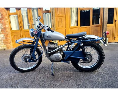
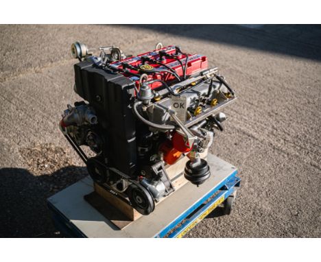
From the 'DJH Ford Collection', an original, unused/uninstalled factory bench-tested RS500 engine; 'automotive art' or as a spare, either way it's magnificent.   The Sierra RS Cosworth might have been the first Ford to be honoured with the Cosworth name, but the relationship between the two companies dates back to the 1960s when the American car producer funded the development of a 3-litre V8 engine for Lotus' F1 car. The resulting V8, known as the DFV, then went on to be a dominant engine in Formula 1 for over a decade, winning 155 Grand Prix.Despite reigning supreme on track and in rallying throughout the decade, by the end of the 1970s, Ford’s motorsport dominance was on the wane. Even the once all-conquering Ford-Cosworth DFV Formula 1 was starting to lose out to more modern turbocharged units. This was painfully obvious when a Ford VIP contingent visited the 1983 British Grand Prix at Silverstone, where a Touring Car race supported the main event and Ford bosses, Stuart Turner and Walter Hayes, were dismayed to witness a group of Capris being humbled by SD1s with Rover V8 power.The solution was again to be found with the engineers at Cosworth who had previously developed a four-cylinder engine for Ford's racing and rallying saloons in the late 1960s and 1970s. The Mk1 Escort RS1600, which replaced the Lotus-powered Twin Cam Escort, had a 1,600cc engine with a 16-valve head designed by Cosworth called the 'BDA'.The formula for the Sierra wasn’t dissimilar to that of the earlier homologation Escorts and Cosworth and the trusted cast iron block from Ford’s single-overhead cam, the T88 Pinto that was used in the Escort RS2000, was utilised to form the basis of this new engine. Code named 'YAA', Cosworth designed an aluminium head to suit the Pinto block with two belt-driven cams operating 16 valves; eight 35mm diameter inlet valves and eight 31mm exhaust. Compared with the basic Pinto, almost everything changed except for the cylinder block itself and the new head and valve gear were matched to a new steel crankshaft, rods, pistons, and sump, and hydraulic valve lifters were a given. A turbocharger was always part of the plan and a Garrett AiResearch T3 with an intercooler were selected boosting power to 201bhp at 6,000rpm and 205lb/ft at 4,500rpm, in road car spec.With a new facility to produce the production-ready version (now with the 'YB' prefix), the first prototype started test-bed work in Northampton in June 1984 although the first engines and test cars didn’t go to Weber-Marelli in Italy until September 1984 before subsequently being 'signed off' by mid-1985.First utilised in the 3-door Sierra RS Cosworth of 1986 - introduced for homologation to allow Ford to go 'Group A' Touring Car racing - the new production 1,993cc YBB engine proved to be legendary, both on road and track. When the ruling allowed for an 'evolution' upgraded model to compete, spawning the RS500 Cosworth, the YB engine stepped-up too, the grateful recipient of further development.To cope with the requisite extra horsepower required, the original YBB motor was switched to an uprated 'YBD' unit which featured a reinforced block (still cast-iron) with thicker walls (note, there are two main types of YB block - known as the 205 and the 200, the latter is a thicker-wall design and was found in 4 x 4 versions, such as the Escort and 1990 Sapphire; the RS500 block was also a thick-wall design but stamped 205, recognisable by its smaller core plugs). Other differences included a bigger Garrett AiResearch T04 turbo plus a larger air-to-air intercooler, pressurised oil-cooled pistons, uprated oil, water and fuel pumps and beefier (orange) air hoses for the radiator and turbo, and a re-mapped ECU.Ford pushed the limit of the Homologation rules to the maximum for the RS500 and the road car featured components that weren’t at all functional but allowed legal modifications on the race cars. The RS500's Cosworth YB engine had an inactive secondary injection system fitted so, when activated on the race cars, their engines could swallow greater amounts of fuel and produce more power (with a different engine map and the second injectors squirting fuel, race RS500s made an 'easy' 485bhp and it didn’t take much more before the engine was putting out 525bhp).In addition, the YBD’s induction system was reconfigured with a bigger intake plenum which, along with a new secondary fuel rail, required one corner of the battery tray be cut away for installation, and a slightly different thermostat housing and alternator bracket. On the road cars, the RS500's power rating went from 201bhp to 224bhp at an unchanged 6,000rpm. Peak torque was the same as the regular Sierra RS Cosworth: 204lb/ft at 4,500rpm.Although undoubtedly successful before, the Ford Sierra became really dominant when the RS500 took to the circuit, winning the 1988 DTM championship, the 1989 Spa 24 Hours, the 1988 and 1989 Bathurst 1,000km, the 1988 and 1989 Australian Touring Car Championship, the 1988 and 1989 Japanese Touring Car Championship and the 1990 British Touring Car Championship.The engine presented here is a Cosworth factory, bench-tested YBD unit, #YBD 0626, designed and built for an RS500 road car. Tested and signed off by Cosworth, confirmed by a tag, it's understood to be one of the very last YBD engines to leave the factory. We understand that it has always been complete (i.e. never as separate components), has never been apart, rebuilt nor ever installed into a car, being sat on its plinth since manufacture. All the factory elements appear to be present and correct, the stampings included, even down to the original FRAM oil filter!Meticulously kept - in pride of place even - alongside his two RS500 cars, it has been owned by our vendor for last 14 years. He sourced it from an ex-pat Ford aficionado living in Malta who had acquired it previously in the UK (some 6 years before). Rumour has it that only a handful of unused YBD engines still exist.For the serious collector or enthusiast, this 'jewel' of an engine is supplied with a bespoke glass display case and is now ready to be appreciated by its next custodian; what an opportunity.N.B. Please note this lot will be sold with a buyers premium of 20% plus VAT as per our usual memorabilia terms.Click here for more details and images

Lot 183

L'Ecosse Royaume, Sanson, coloured map with titled cartouche, on two sheets, framed under glass, 53 x 42cm

Lot 366

Quantity (13) of the c1965 special edition of the London Underground diagrammatic POCKET MAP, a paper version of the Garbutt design produced for distribution to arriving passengers at the British European Airways (BEA) West London Air Terminal in Cromwell Road with walking directions to Gloucester Road station. These copies have never been used and originated from LT stores. Excellent to mint condition, one or two may have minor storage marks. [13]

Lot 138

1933 London Underground H C Beck diagrammatic, card POCKET MAP from the first-year series titled 'Underground Railways of London'. Issued c.September 1933 and has print reference 33-2791. Shows the escalator connection between Bank and Monument stations. An excellent example, crisp and firm. [1]

Lot 255

1977 London Underground quad-royal POSTER MAP designed by Paul Garbutt with date-code 10/77 No 1 1978. The Piccadilly Line extension from Hatton Cross to Heathrow Central is now open. It also shows the first stage of the Jubilee Line (no longer the 'Fleet' Line) from Baker St to Trafalgar Square as under construction. British Rail's North London line is now added to the map as is the Northern City, former Underground, now British Rail Line. In very good condition with minor edge scuffs and nicks. [1]

Lot 145

Quantity (11) of London Transport (LPTB) ANNUAL REPORTS including the first issue from 1934. The early issues include the pull-out photos and maps including the News Works Programme map in the 1938 copies. Comprises issues for 1934, 1935, 1937, 1938 (3 copies), 1939 (2 copies), 1945, 1946 and 1947. All are in very good condition. [11]

Lot 124

1933 first edition of the H.C. Beck London Underground diagrammatic, card POCKET MAP with the famous cover slogan "A new design for an old map....." and print-code 750M - 1-33. This is a lightly-used example to which has been added by hand the words "Fares from Bank Sta" on the cover and the actual fares in shillings and pence by most of the station names. [1]

Lot 344

1927 London Underground linen-card POCKET MAP from the Stingemore-designed series of 1925-32. This is the January 1926 issue, with light-green cover, from the smaller-size first sub-series. In very good, lightly-used condition with a couple of small marks on the rear cover. [1]

Lot 177

1966 football World Cup special edition of the London Underground POCKET MAP, the Paul Garbutt version of the diagram. Features 'World Cup Willie' on the cover, the mascot of the England team who became world champions that summer. A paper issue with details and small maps on the reverse for getting to Wembley and White City stadia. In excellent condition with just a light crease. [1]

Lot 370

c1908 Central London Railway POCKET MAP. Although the cover and reverse side are purely CLR (including the CLR's own line map), the map itself is the standard Underground Group map of the time and this had clearly been offered to non-members of the group (the CLR was finally absorbed into the Group in 1913) in an effort to portray a unified network. An unusually good example of this rather scarce map, some extra fold creases suggest that it may have originally been inside a guidebook. [1]

Lot 158

1863 MAP of Metropolitan Railways & Misc Improvements prepared for the 1864 Parliamentary Session and published by Edward Stanford in Dec 1863. Colour-coded to show lines in operation, sanctioned and proposed as well as the proposed new boundary of the Metropolitan Railway District. Opens out to 35" x 29" (89cm x 74cm) and is in very good condition. Has been sectioned, mounted on canvas and bound into a hard cover with gold-leaf titling on the spine. [1]

Lot 398

1923 London Underground MAP of the Electric Railways of London "What to see & how to travel". Designed by MacDonald Gill with his distinctive style of calligraphy and map border, this is the issue dated 1/1/23. British Empire Exhibition stations are depicted with red dots. A superb example in excellent, unblemished condition. [1]

Lot 272

Special edition of the No 1, 1937 London Underground diagrammatic card POCKET MAP produced for the Sakai Co at 5 Denmark St in the then 'Little Tokyo' area of London. Sakai were a Japanese trading company with a shop and travel agency at the Denmark St address. Overprinted for Sakai with an arrow to Tottenham Court Station and one can assume that the map was produced for Japanese tourists. In very good, lightly-used condition with just a little light creasing and the odd minor blemish. [1]

Lot 331

1906 POSTER MAP of the London United Electric Tramways 'showing connections with allied lines, Metropolitan District & Underground Railways of London'. Shows the company's lines plus authorised extensions, depôts, central power station etc as well as connecting LCC Tramways, Harrow Road Tramway and County of Middlesex Light Railways. Has a colour-coded index of the Underground and two panels listing lines, fares and distances. A most unusual survivor. Measures 40.5" x 30" (103cm x 76cm), mounted on card and in good condition, one short repair with archive tape. [1]

Lot 83

c1930 London Underground linen-card POCKET MAP from the Stingemore-designed series of 1925-32. This is the first to show the Piccadilly line extensions to Cockfosters and Hounslow as under construction and is the red-cover version which refers to 'Lordship Lane', subsequently named 'Wood Green'. A lightly-used example with small spots and stains, minor damage at one fold edge. [1]

Lot 275

1970s London Underground CAR DIAGRAM (route map) for the Metropolitan (Hammersmith & City) and Circle Lines. Undated but carries the 1976 amendment for the renaming of Charing Cross station to Embankment. A formica version which we therefore assume was fitted to A-Stock trains. In very good, ex-use condition (the image has some photographic glare not present on the item). [1]

Lot 248

1924 London Underground POCKET MAP of the Electric Railways of London "What to see and how to travel". Winter 1924/25 (November 1924) edition. An excellent example in very good condition indeed with barely a blemish. [1]

Lot 390

1924 Metropolitan Railway small POCKET CARD MAP "How to get to and from the British Empire Exhibition". Illustrated with a new electric locomotive on the cover, this is the Met's version of an Underground pocket map but highlighting its own lines in red with the District Railway and the Tubes in blue. Opens out to 5.75" x 4.5" (15cm x 11cm). This is the blue cover version. In excellent condition. [1]

Lot 299

1919 London Underground MAP OF THE ELECTRIC RAILWAYS OF LONDON 'What to See & How to Travel' with print-code 395-500M-2-10-19. A very good example with just a very small parting at one fold-corner and traces of adhesive down the outside spine where it was originally tipped into a guidebook. [1]

Lot 235

1933 London Underground H C Beck diagrammatic, card POCKET MAP from the first-year series titled 'Underground Railways of London'. This is the edition with no print-code, issued c. August 1933 and has 'LPTB' inside the bullseye logos. Refers to re-naming of Dover St station to Green Park and the merger of Holborn and British Museum stations, all in September that year. An excellent example, crisp and firm with just a few light foxing spots mainly on the cover side. [1]

Lot 295

1924 East Surrey Traction Co TIMETABLE BOOKLET. The Spring Edition, dated 17-4-24. In very good, lightly-used condition. The centre-fold map is present. [1]

Lot 208

Selection (9) of assorted 1960s/70s bus POSTERS, double-crown and other sizes. Comprises 'For quick delivery, send your parcels by bus', 4 x 1971 Decimal Currency examples (probably National Bus Company), 1972 Alder Valley 'Happy New Year', Thames Valley 'Drivers, Conductors/resses wanted', Equal Opportunities Commission 'Mary Curran - bus driver' and a route map of Thames Valley, Newbury & District and South Midland services. Generally in very good condition with small blemishes. [9]

Lot 227

Selection (4) of London Tramways ephemera comprising 1906 West Ham Corporation Tramways OFFICIAL GUIDE (one map is missing, the other is incomplete), 1923 London United Tramways 'Fares & Stages' card booklets for (i) Acton, Hanwell & Hounslow depôts and (ii) Fulwell depôt plus a 1930-33 Walthamstow Corporation Tramways Old Age Pensioners Pass (unused). The first item is well-used, the others are generally very good. [4]

Lot 250

1923 DIRECTORS' REPORT, ACCOUNTS & MAP of the London and Blackwall Railway Company. Operational since 1840, the company was compulsorily absorbed into the LNER at 1923 Grouping and this was probably the last independent report. Connecting central London to the Docks, the line was closed to passengers in 1926 and to goods traffic in 1968. Much of its infrastructure has since been used for the Docklands Light Railway. Map measures 19" x 14.5" (49cm x 37cm). The whole forms a stapled set with tape binding. Generally in good condition. [1]

Lot 178

1919 London Underground MAP OF THE ELECTRIC RAILWAYS OF LONDON 'What to See & How to See it' with print-code 209-500M-18-6-19. An unusually good copy, in excellent condition with just minor blemishes. [1]

Lot 22

1933 first edition of the H.C. Beck London Underground diagrammatic, card POCKET MAP with the famous cover slogan "A new design for an old map....." and print-code 750M - 1-33. In very good, lightly-used condition with small knocks at the corners which could be pressed flat if so wished. [1]

Lot 389

1933 first edition of the H C Beck London Underground POCKET DIAGRAMMATIC CARD MAP with the famous cover slogan "A new design for an old map." This is the much less-common version over-printed on the cover with the name of the new London Passenger Transport Board which took over in July 1933. A very good example, just lightly-used with light horizontal creasing at one place. [1]

Lot 343

1926 London Underground linen-card POCKET MAP from the Stingemore-designed series of 1925-32. This is the April 1926, with light-green cover, from the smaller-size first sub-series. In very good, lightly-used condition. [1]

Lot 162

1973 London Underground quad-royal POSTER MAP designed by Paul Garbutt with date-code 4/73 June 1973. This issue shows the Piccadilly Line extension from Hounslow West to Heathrow Central as under construction. Strand station is crossed through with a note at the foot of the map that it is closed from June 1973 to 1976. In very good condition with just a few minor edge-scuffs and nicks. [1]

Lot 111

Assortment (8 items) of bus/tram ephemera incl 1931-2 Garcke's Motor Transport Year Book, early London bus conductor's enamel licence badge, 1931 Hensman's timetable leaflet, City 1931 & 1946 timetable leaflets, 'City' cloth badge, c1915 'Tramway Trips & Rambles' (LUT/MET) incl fold-out tram map and 1930-31 LCC Tramways 'The Platform' booklet. Generally in good to very good condition. [8]

Lot 68

1927 London Underground linen-card POCKET MAP from the Stingemore-designed series of 1925-32. This is the June 1927 issue, with mustard cover, from the smaller-size first sub-series. A very good example, crisp and firm with just a small '3' written on the cover. [1]

Lot 139

1933 London Underground H C Beck diagrammatic, card POCKET MAP from the first-year series titled 'Underground Railways of London'. Issued c.December 1933 and has print reference 33-3636. Shows the escalator connection between Bank and Monument stations. An excellent example, crisp and firm. [1]

Lot 113

1925 London Underground MAP of the Electric Railways of London "What to see and how to travel", Summer 1925 edition. Shows the British Empire Exhibition site and nearest stations with red dots. A very good example with just very light signs of use. [1]

Lot 84

1969 (March) London Underground quad-royal POSTER MAP designed by Paul Garbutt with date code 4/69. Shows the Victoria Line section to Brixton as under construction. A small water stain/damage at the bottom l/h corner, some light creasing, a few short inward tears at the edges and other small edge-scuffs and marks but overall still presents well. [1]

Lot 294

1925 East Surrey Traction Co TIMETABLE BOOKLET. The Winter Edition, third issue, dated 21/1/25. Generally in very good, lightly-used condition. The centre-fold map is present. [1]

Lot 108

1976 London Underground quad-royal POSTER MAP designed by Paul Garbutt with date-code 7/76 (No 1 1976). This issue shows the Piccadilly Line extension from Hatton Cross to Heathrow Central as under construction with the A1 Express Bus in operation. It also shows the first stage of the 'Fleet Line' from Baker St to Trafalgar Square as under construction and the Northern City Line as due to open under British Rail in November that year. In very good condition with just edge-scuffing, mainly at the lower edge. [1]

Lot 247

1924 London Underground POCKET MAP of the Electric Railways of London "What to see and how to travel". June 1924 edition. Map by J C Betts. Shows the British Empire Exhibition stations. An excellent example in very good condition indeed with barely a blemish. [1]

Lot 13

1974 (with over-printed date 'June 1973') London Underground quad-royal POSTER MAP designed by Paul Garbutt. Shows both the Piccadilly extension to Heathrow and first stage of the "Fleet" Line from Baker Street to Strand as 'under construction'. Strand Station is shown crossed through with a notice at the foot of the map that it is closed for rebuilding. Print-code 274/1222M/5000 June 1973. In excellent condition with just minor edge-scuffs in places. Folded. [1]

Lot 277

1930s London Tramways items (3): a pair of card FARECHARTS in good, ex-use condition comprising ex-Ilford Corp routes 91 and 93 dated April 1935 (these formerly un-numbered services only ran from 1934 to 1938 when they were converted to trolleybus operation) and route 30 dated 1936 (converted to trolleybuses in 1937). Plus a hand-drawn & coloured MAP of London's Horse Tramways Systems by Alf Wm Monk dated July 1931. Colour-coded with a list of all systems & operating dates. Measures 11.5" x 9.5" (29xm x 24cm), mounted on card, a little age-darkened. [3]

Lot 327

c1931 London Underground linen-card POCKET MAP from the Stingemore-designed series of 1925-32. This is the red-cover version that shows the Piccadilly line extensions to Sudbury Town, Hounslow and to Cockfosters as under construction. An excellent example, crisp and firm, with only minor signs of use. [1]

Lot 236

1933 first edition of the H.C. Beck London Underground diagrammatic, card POCKET MAP with the famous cover slogan "A new design for an old map....." and print-code 750M - 1-33. In very good, lightly-used condition with just a few very small blemishes. [1]

Lot 101

1932 "Stingemore" linen-card London Underground POCKET MAP, the very last issue before the switch to the Beck diagram. All the Piccadilly Line extensions are now shown as open although the actual 1932/33 opening dates are listed on the reverse . An excellent example, crisp and firm with only very minor signs of use. [1]

Lot 246

Bundle (33 items) of London tramway material comprising 21 x LCC Tramways c1911-1930s GUIDEBOOKS, LEAFLETS, TRAMWAY ACCOUNTS etc (includes one LCC River Steamboat map & guide) plus 12 of the F Merton Atkins large-scale PLANS drawn by him in the 1950s and depicting tram routes, topography and historical notes for various areas of London at specific dates, many are 1914. Items are mostly in good to very good condition, the early guidebooks show the usual wear from use. [33]

Lot 281

1979 London Underground quad-royal POSTER MAP designed by Paul Garbutt with date-code 3/79. Shows the first stage of the Jubilee Line open from Stanmore to Charing Cross. British Rail's North London line is now added to the map as is the Northern City, former Underground, now British Rail Line. An excellent example with minor edge scuffs and one very small hole noted. Folded. [1]

Lot 291

Selection (3) of 1920s Metropolitan Railway items comprising c1925 fold-out-leaflet 'Watford's New facility' publicising the Met's bus service connecting their station to the town centre, 1927 edition of 'Metro-Land' GUIDEBOOK, complete with fold-out double-sided map, and c1924 LEAFLET 'Electric Trains to North West Suburbs & Country Districts'. All are in lightly-used condition with a little wear. [3]

Lot 252

1863 "DIAGRAM" (map) of Railways in the Metropolis published by Day & Son for a Parliamentary Session. Shows lines Constructed (black), Authorised (dotted) and Proposed (blue) as well as a shaded area depicting the Metropolitan Limit as defined by the 1846 Commission. All the lines have their names alongside. Measures 12.5" (32cm) square and is in very good condition with just a very small loss at the l/h edge, outside the map boundary. Folded. [1]

Lot 8

c1928/9 London Underground linen-card POCKET MAP from the Stingemore-designed series of 1925-32. This is one of the two first issues of the larger, second series and is the one with the pale-green cover. These were issued before any of the early 1930s line extensions were projected. An excellent example, crisp and firm, with little or no signs of use. [1]

Lot 123

c1928/9 Metropolitan Railway POCKET MAP, the Met's version of the London Underground map, with its own lines in red and the rest of the system in blue. This is the green-cover version of the issue with print-code G.3595/65M and 16167 Met as well as G3583/100M on the map-side, undated but circa 1928/9. In very good, lightly-used condition. [1]

Loading...Loading...
  • 109182 item(s)
    /page

Recently Viewed Lots