We found 109198 price guide item(s) matching your search

Refine your search

Year

Filter by Price Range
  • List
  • Grid
  • 109198 item(s)
    /page

Lot 29

Vintage Daily Express War Map, by George Philip's and Sons Ltd. Showing Arguments of Each European Country. Study There War Strength From This Cart. Size 29 x 39 Inches, Folded.

Lot 3

8 Antique Maps of Welsh Countries, Hand Coloured By Dugdales, Chapman and Others, 2 Caernarvonshire, Wales Map. Montgomery shire, 2 Denbighshire,2 Flintshire.

Lot 811

JOHN OGILBY (1600-1676) Scottish The Road From London to Yarmouth Hand coloured engraving; together with a 17th/18th century Map of the Isle of Man and British Coast, hand coloured engraving, inscribed to the Honourable Sir John Lowther, Bart., one of the commissioners for executing the office of Lord High Admiral of England. 45.5 x 35 and 56 x 44 cm respectively, both framed and glazed. (2) CONDITION REPORTS: Both generally in good condition, expected wear, some staining and fading, each with foxing and fold lines, the latter with repaired tear.

Lot 289

A Framed Map of Shropshire by Greenwood & Co

Lot 294

A Framed Map of Germany

Lot 391

LETTER SCALES & MAP. A Victorian brass letter scales, by Winfield, Birmingham, & an 1882 Post Office directory map of London.

Lot 584

CIGARETTE CARDS. Various part sets of cigarette cards, a Daily Express war Map & a Daily Telegraph World Map. CONDITION REPORTS: Condition of cigarette cards variable, some poor.

Lot 715

BOOK: CORNISH MINING. 'Mongst Mines & Miners; or Underground Scenes by Flash Light', by J.C. Burrow & William Thomas. A book of photographic prints & descriptions of the subjects photographed. Published 1893. Repaired copy(1992), replaced in covers with new end papers (list or repairs carried out included). CONDITION REPORTS: Generally good. Cover slightly bowed, some marks, wear to spine & corners. Pages good with some darkening to edges & occasional mark. Photographs very good. Mine section map has tape repair. Photograph tissue covers present but with some foxing.

Lot 602

2 tier oak map drawer

Lot 315

A late Victorian 1/2500 scall ordanance survey map, the map on linen of Hatfield and surrounding area in Essex

Lot 459

Three 19th century maps of London, together with a 19th century map of Buckinghamshire (4)

Lot 102

Hand-coloured engraving map of Westmorland by Robert Morden

Lot 104

Vintage Ashley Hall Coal Map, A map of the Atherstone Iron Co, in leather binding and Sifton Praed & Co, "Heythrop Hunt"

Lot 14

Assorted antiquarian and other bindings, including:- Kipling, Rudyard "The Second Jungle Book", McMillan & Co 1895, superb pictorial gilt front board showing a cobra, on blue cloth, all edges gilt, aeg, four observer books, "British Butterflies", "British Wildflowers, Trees and Shrubs" , "British Wildflowers", various children's books "The Polar Book" pub. E Allom (1930), folding map, pictorial paper covers, "Mountain Craft, the Journal of the Mountaineering Association", "Mount Everest 1951" (No.16, Summer 1952) "The Cambridge Review" May 10th 1929, "Socialist Commentary" April 1950, "The Studio Magazine", limp covers 1936, 37 and 38, four copies, numerous volumes of "The Geographic Journal" 1920's, 1930's and other periodicals (2 boxes)

Lot 195

10 Great Somerford Royal Wedding covers, 1973, interesting addresses ( HM The Queen) and a ministry of agriculture map

Lot 33

Assorted volumes including:- Venables, Bernard "British Sports Past and Present, Fishing" 1953, blue cloth, dust jacket Pike, Oliver G "Through Bird Land Byways with Pen and Camera" Johns, Rev C A "British Birds in their Haunts", George Routledge Fry, C B, etc. "Cricket", pub. C Arthur Pearson 1903, yellow pictorial cloth Evans, John "Picture of Worthing...", 2nd edition in two volumes, printed and sold by William Phillips 1814, folding frontis, two volume one, another folding plate, colour frontis to second volume offsetting on title page, a coloured map, half-leather, all marbled edges and gilt titles and other volumes (1 box)

Lot 7

After Norden hand coloured engraving, map of Surrey and surrounding counties, 30 x 39cms

Lot 109

An 18th century map, 'Plan of the Bay, Rock and Town of Gibraltar', engraved by William Faden, dated 1781

Lot 249

MAP OF PARIS, in a distressed frame, 114cm x 206cm.

Lot 57

Philips' 19th century fold-out coloured map of the United States of America, containing a hand-written account based on a visit made in 1886 on board the White Star steamship Britannic

Lot 70

Map of France divided into Metropolitan Circles and Departments as decreed by the National Assembly January 15th 1790, published by GG Robinson & J Mawman 1801, engraved for Gutheries New System of Geography, 41x37cm, framed & glazed

Lot 399

Vasant Narayan Chinchwadkar, 20th century, figures, ink and watercolour, 26 x 37cm, Terence Macklin, First to the Bird, Labrador, ltd. ed, 132/500, signed in pencil to the margin, E. M. Hattrell, Harvest, oil on canvas, together with various hunting prints, a framed map etc (13), together with a collection of cricketing caricatures

Lot 601

After Robert Morden, map of Norfolk, 38 x 58cm, together with three others

Lot 100

SAXTON & KIP antique coloured map of 'Brecknoc', 10.75 x 12.75 ins (27 x 32 cms)

Lot 101

OWEN & KIP antique coloured map of 'Penbrok', 11.25 x 13.5 ins (28 x 34.5 cms)

Lot 102

SAXON & HOLE antique coloured map of 'Glamorgan', 10.75 x 13.25 ins (27 x 34 cms)

Lot 103

SAXTON & HOLE antique coloured map of 'Monumethensis', 11 x 13.5 ins (28 x 34.5 cms)

Lot 104

SAXTON & KIP antique coloured map of 'Flint', 10.5 x 12.75 ins (27 x 32 cms)

Lot 105

SAXTON & KIP antique coloured map of 'Mongomery', 10.5 x 12.75 ins (27 x 32 cms)

Lot 106

An antique coloured map of 'Cantabri' 6.25 x 7.75 ins (15.5 x 19.5 cms) together with an antique road map of 'Huntingdonshire' 7.5 x 4.75 ins (18.5 x 12 cms)

Lot 108

W Palmer for Carington Bowles antique coloured map of 'Huntingdonshire' 10.25 x 7.75 ins (26 x 20 cms) and another pictorial antique map of 'Huntingdonshire' 11 x 7.75 ins (28 x 20 cms)

Lot 111

JOHN OGILBY antique coloured road map 'Chester to Cardiff', 13.75 x 17.5 ins (35 x 44 cms)

Lot 112

JOHN OGLIBY antique coloured road map 'St David's to Holywell', 13.75 x 17.25 ins (35 x 44 cms)

Lot 113

JOHAN BLAEU antique coloured map of 'Glamorgan Shire' 16.5 x 21.5 ins (41 x 54 cms)

Lot 115

A small seventeenth century coloured and tinted antiquarian map of Wales, probably Humphrey Llwyd, 3.25 x 4.75 ins (8 x 12 cms)

Lot 117

'A New & Correct Map of North Wales' fully-coloured and from 'Walpoole's New & Complete British Traveller' by Alex Hogg, (unframed) 9.5 x 14.25 ins (24 x 36 cms)

Lot 118

CHRISTOPHER SAXTON & ROBERT VAUGHAN a coloured and tinted antiquarian map of 'Brecknoc', 11 x 13 ins (28 x 32 cms) and another SAXTON & KIP of 'Montgomery' (both unframed)

Lot 121

J CARY coloured antiquarian map of 'North Wales', an earlier, smaller coloured map of 'Carnarvan Shire' and a road route map 'Welshpool to Carnarvan'

Lot 91

JOHN OGLIBY antique road map entitled 'The Road From Welshpool com Montgomery to Carnarvan in North Wales', 13.25 x 16.5 ins (33 x 41.5 cms)

Lot 92

SAXTON & HOLE coloured antique map of 'Caernarvo', 9.75 x 12 ins (25 x 30 cms)

Lot 93

MERCATOR antique-coloured map of 'Anglesey', 6.5 ins x 8.25 ins (16 x 21 cms)

Lot 95

Saxton & Kip antique-coloured map of 'Radnor', 10.5 x 12.5 ins (27 x 32 cms)

Lot 96

CHRISTOPHER SAXTON antique-coloured map of 'Anglesey', 10.5 x 7.5 ins (27 x 19 cms)

Lot 97

SAXTON & KIP - antique-coloured map of 'Denbigh', 10.5 x 12.75 ins (27 x 32 cms)

Lot 98

SAXTON & KIP antique-coloured map of 'Merionith', 10.5 x 12.75 ins (27 x 32 cms)

Lot 99

SAXTON & KIP antique coloured map of 'Caermardi', 10.75 x 12.75 ins (27 x 32 cms)

Lot 510

A STESCO MAP MEASURER, foreign made in original card box, and a chromed POCKET COMPASS, unboxed

Lot 1148

A selection of assorted car manuals, instruction books, brochures and ephemera including the Hillman Minx instruction book, an early map, a Lea Francis instruction book for the Light 6 model etc.

Lot 1368

A Pratts Motor Spirit Filling Depots for Commercial Vehicles booklet with map inside.

Lot 1390

A good Firestone Tyres enamel sign depicting the geographica main roads map of England and Wales, 29 x 49"

Lot 913

The AA Road Book of England and Wales, pre 1928 and four AA handbooks for 1927, 1928, 1929 and 1930; also five AA document wallets including two marked Irish Touring Documents, also an early AA map box containing an assortment of AA literature including Scotland map and an AA badge.

Lot 359

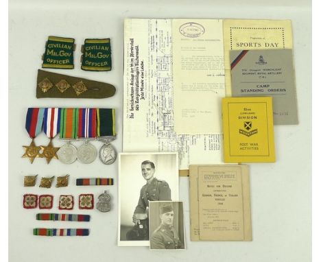
A group of medals, war diaries and associated WWII memorabilia relating to Captain James Alexander, Highland Light Infantry, joining in the ranks on 3rd September 1939, rising to become the officer in charge of the Glenshee Lodge Winter School preparing soldiers for the invasion of Norway and concluding the War as a Regional Intelligence Officer and Civilian Military Government Officer in Hanover. The medals comprise 1939-45 Star, France and Germany Star,Defence and Victory Medals and George VI Territorial Service Medal, together with badges and buttons, diaries covering October 9th 1939 to July 14th 1945, a silk map of France, BAF money, German binoculars, a Great Coat, further uniform and sundries including a layout of an execution block at Buchenwald 'Jede Minute eine Leiche'.

Lot 118

40th Anniversary of the sinking of U589 by HMS Onslow official navy cover. RNSC(3)19 variant by Hans Rossbach. No 18 of 29. Signed by Carl Borm, commander of U-592 in action against Convoy PQ18. Includes copy of original operation map showing route of U-592 between 13th and 27th September 1942. Good condition

Lot 280

CAPTAIN GREENVILLE COLLINS (British, fl. 1690s), 'Holy Island, Staples and Barwick', sparsely coloured original map. 17.5" x 22.5" (45cm x 56cm) CONDITION REPORT: Good, mounted over plate mark.

Lot 188

A pocket knife and scissor set, pen knife and a vintage map walker and compass

Lot 339

A framed J Cary map of Essex dated 1787

Lot 395

A framed early map of Cambridgeshire, 60cm x 49cm

Lot 396

An Antique Map of the Road, from London to Carlyle, commencing at Darlaston Bridge in the Chester Road. The Road from Carlyle to Berwick, drawn and engraved by J.Gibson, approx 30 x 19 cms

Lot 49

Souvenir of The Siege of Mafeking from original photographs by D.Taylor. This book was was presented by Mr W R Langford an ex member of the South African Constabulary who served under Baden-Powell in November 1950 together with a map showing principal engagement and defence work during the siege.

Lot 50

A Copy of a "New History of Gloucestershire" from its first foundation to the present time illustrated with a map of the county and views of gentlemen's seats, printed by Samuel Rudder in 1779 (possible first edition).

Loading...Loading...
  • 109198 item(s)
    /page

Recently Viewed Lots