We found 109182 price guide item(s) matching your search
There are 109182 lots that match your search criteria. Subscribe now to get instant access to the full price guide service.
Click here to subscribe- List
- Grid
-
109182 item(s)/page


Lot 311
Richard William Seale (early 18thC). A Correct Chart of the English Channel, from the No. Foreland to the Lands End on the Coast of England, and from Calais to Breast on the Coast of France, hand coloured engraving, with vignettes for the Isle of White and Adjacent Harbours, Plymouth Sound, Falmouth Haven and the Isles Of Scilly, for Mr Tindal's continuation of Mr Rapin's History, circa 1745, 39cm H, 48cm W, together with a map of Surrey, After Robert Mordon, 37.5cm H, 45cm. (2)


Lot 483
A Brown (British, late 20thC). Still life of flowers in a glass vase, charcoal and pastel, signed and dated 1971, 17cm H x 36cm W., J & C Walker, map of the county of Lincolnshire, marked with places of meeting of fox hounds, county divided into hunts, 41cm H x 34cm W., and a 19thC half length portrait of a lady, watercolour and pencil, monogrammed, 8.5cm H x 12.5cm W. (3)


Lot 5
Parson and White "History Directory and Gazetteer, of the Counties of Cumberland and Westmorland, Furness, Cartmel & the Lake District" printed for W White & Co, 1829, leather bindings with rebound spine with gilt lettering. CONDITION REPORT: As far as we can tell there is only one map for this edition, a map of Whitehaven and this map is missing. The binding and text are in good condition with only minor marks.

Lot 55
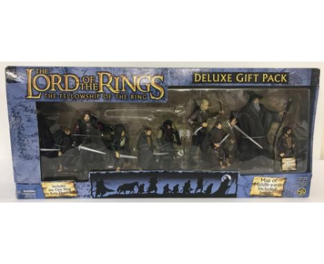
A boxed 2004 Toy Biz LOTR The Fellowship of the Ring Deluxe Gift Pack, item #81084. Box shows signs of wear but contents remain in interior packaging, unopened. Box contains figures of: Aragorn, Samwise Gamgee, Boromir, Merry & Pippin, Gimli, Legolas, Frodo Baggins and Gandalf (battery operated) together with weapons and bonus figure of Peter Jackson (director). Also included is a map of Middle-Earth and The ring necklace.


Lot 5200
Campion's Map of Railways, Docks, Towns and Works in South Wales, Published by C.W. Campion, Neath, Glamorganshire, [n.d., c. 1875], title flanked by 'aerial' views of the Western and Eastern Hemispheres, vignette of a coal steamer to lower margin, lithograph with some colouring, forty-folds laid on canvas, folding into a red cloth wrap, upper cover with applied label, marbled endpapers and pastedown, 79cm x 116cm (open), 8vo


Lot 169
SMALL COLLECTION OF MAPS, to include: VARIOUS LARGE SCALE FOLDING MAPS ON CLOTH, ORDINANCE SURVEY, various locations and sheets, together with a SELECTION OF 1 inch OS MAPS AND OTHERS, PUBLICATIONS RELATING TO MAP READING including A DESCRIPTION OF THE ORDINANCE SURVEY LARGE SCALE MAPS (sixth edition), etc


Lot 194
NINETEENTH CENTURY HAND COLOURED STEEL ENGRAVING ?ENGRAVED FOR THE MODERN UNIVERSAL BRITISH TRAVELLER? ?A View of the Rocks and Cavern at Castleton, Called the Devil?s Arse in the Peak, Derbyshire? 6 ½? x 10 ½? (16.5cm x 26.7cm)AND A REPRODUCTION MAP AFTER CHRISTOPHER SAXTON'Lancashire', (2)

Lot 19
Hasted (Edward), The History and Topographical Survey of the County of Kent, 2nd edn, 12 vols, engr frontis to each vol, (2 fldg), 26 maps (25 fldg) 20 plts (one fldg map missing in vol III, "Westerham") hf mor gt, 8vo, 1797-1801 (12) sold with an annuity bond, "Sir Edwd Hales, Bart and his son to Henry Halsey Esq", Nov 1, 1787, and other inclusions.


Lot 525
Francis Hill (17th/18th Century) - Ink and watercolour on vellum - Estate plan of land in the parish of Hoath, with title "A MAP & defcription of a Certaine Farme of Land belonging to the heirs of Tho: Knowler Gent. fituate lyeing & being in ye Parifh of Hoath in ye County of Kent fhewing ye Naime & Alfo ye Quantity in Each feverall feild with ye Contents of ye whole, alfo fhewing ye Trees, Gates, Ftiles, ... places, Ponds, footpaths & ... Roads leading... or by ye Faid land, likewife fhewing ... fence belongs to ye land ... ... with ye Names of thefe Perfones whofe land bounders thereunto by ye Order of ye... faid Owners Meaford & Mapd by me Fran: Hill SC 1708", with two framed cartouches of baroque design with putti supporters, and with Coat of Arms to lower right and conjoined compass above a rule, 18.5ins x 19ins in Hogarth frame and glazed


-
109182 item(s)/page