We found 109198 price guide item(s) matching your search
There are 109198 lots that match your search criteria. Subscribe now to get instant access to the full price guide service.
Click here to subscribe- List
- Grid
-
109198 item(s)/page
![Cary [John]: 'Cary's New and Correct English Atlas, Being a New Set of County Maps.......', printed by John Cary, engraver an](https://cdn.globalauctionplatform.com/952eecd7-17b3-4ab7-856d-aac000a0024e/25117dde-ab0b-4899-9967-aacc00bbeb74/468x382.jpg)


Lot 193
Canada.- Gray (Hugh) Letters from Canada, first edition, folding engraved map with border hand-coloured, slightly offset, 3 folding tables, contemporary calf, gilt, minor rubbing and scuffs, [Sabin 28393; Goldsmiths' 19842; Kress B.5510], 8vo, 1809.⁂ A fine copy from the library of the Marquess of Headfort with bookplate. Covers the trade, political relations, laws, customs and climate, with particular attention to the commercial importance of Nova Scotia, New Brunswick and Cape Breton.

Lot 223
Voyages.- Campbell (Archibald) A Voyage round the World...in which Japan, Kamschatka, the Aleutian Islands, and the Sandwich Islands, were visited, first edition, half-title, folding engraved map frontispiece with hand-coloured route and wash border, lightly offset, some foxing and browning, contemporary sprinkled calf, spine gilt with red morocco label, a fine copy, [Forbes 448; Hill 244; Howes C-88; Sabin 10210; Streeter sale 2418], 8vo, Edinburgh &c., 1816.⁂ The editor, James Smith's copy, with his bookplate and presentation inscription on half-title to Count Revdin, whose bookplate is also included. The book was published by Smith for the benefit of the author who had lost both his feet to frostbite following the shipwreck of the Eclipse and after a journey along the coast of Alaska in a long boat to Kodiak. He was sent to Hawaii to recuperate, spending over a year there. "The author lived among the chiefs and then with Isaac Davis...His keen firsthand observations on the social structure and agricultural practices of Hawaiians are of great importance." (Forbes).
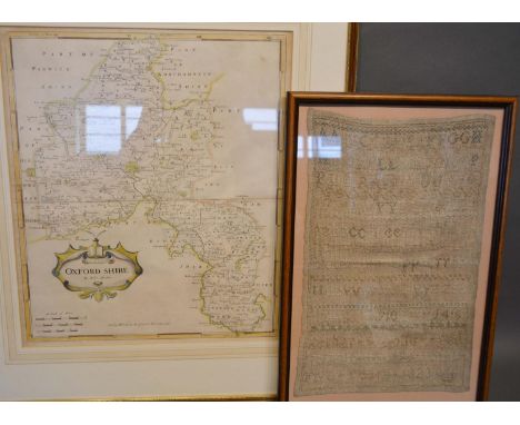
Lot 191
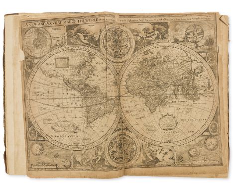
Atlases.- Speed (John) A Prospect of the Most Famous Parts of the World, 22 double-page engraved maps, Printed by John Dawson for George Humble, 1631; bound with The Theatre of the Empire of Great Britaine, 4 parts in 1, engraved title, dedication and 67 double-page maps, woodcut coats-of-arms, Imprinted at London...to be sold by George Humble, 1627, in Prospect world map with small piece of left border missing and a couple of short tears, one repaired to verso, Bermuda slightly trimmed, title laid down, Theatre lacking portrait (as often) and printed title, Yorkshire West Riding with inset plan of York cut out, Kingdom of England partially hand-coloured, some water-staining, occasional slight worming, affecting various maps, some browning, creases and a few marginal tears and repairs, later half calf, worn, [Chubb XXV; Phillips 442; Skelton, County Atlases 18; STC 23040 and 23043], folio⁂ The first Atlas of the British Isles and the first world Atlas compiled by an Englishman.Provenance: Edward Wallis (inscription on title dated 1791) beneath a trimmed 17th century ownership inscription dated ?1644.
Lot 90
Shenstone (William) The Works in Verse and Prose, 3 vol., first edition, vol.1 and 2 with engraved title-vignette, frontispieces, folding map and 3 vignette head-pieces, occasional foxing and browning, contemporary cat's paw calf, vol.3 in contemporary plain calf with some abrasion to upper cover and slight worming through lower margin throughout, 8vo, 1764-69.⁂ An attractive set from the Cullen House library with bookplates.

Lot 18
Vergilius Maro (Publius) Opera, 5 vol., engraved throughout, one double-page map by Condet, 28 plates or portraits and 54 vignettes by Marco Pitteri, occasional light foxing and browning, contemporary blue morocco, gilt, Wodhull arms to upper covers, spines gilt with red morocco labels (missing 4 volume number leabels), 8vo, Brussels, J.L. de Boubers, 1757-65.⁂ Superb set with a distinguished provenance. Michael Wodhull's copy with his arms to upper covers, signature and acquisition notes (including costs) to front endpapers of vol.1. Later bookplate of William O'Brien. According to Wodhull's note, dated March 29th 1780, his original purchase price was £2.2s.2d and the cost of binding £1.12s.6d.

Lot 190
Atlases.- Seller (John) Atlas Minimus or a Book of Geography, engraved title, frontispiece, double-page world map (with neatly repaired tear) and 49 single-page maps only with facing tables (lacking Biledulgerit ?and Congo, Asiatick Islands and Main India), 3 with verso soiled, Mogul Empire map with small portion of loss to lower margin, 2 maps with early ink ownership inscription to margins, occasional light scattered spotting, some light browning and ink inscriptions to endpapers, contemporary sheep, rebacked, preserving original backstrip, [Wing S2465], 12mo, are sold at his house at the Hermitage in Wapping, and in popes head Alley in Cornhill Lond, [1679]⁂ This copy issued without text, the number of maps is often inconsistent between copies.
Lot 188
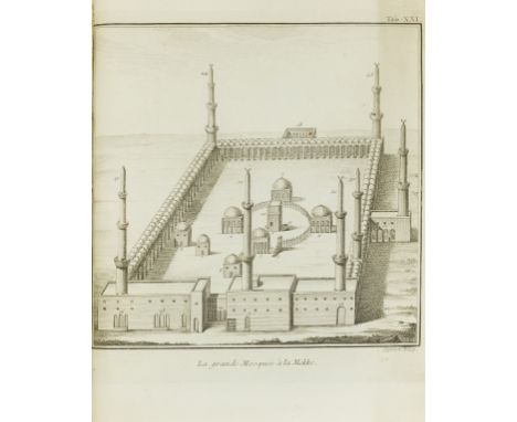
Arabia.- Niebuhr (Carsten) Description de l'Arabie, first edition in French, half-title, title with engraved vignette, 25 engraved plates and maps, many folding, one map and 2 plates of Arabic text with partial hand-colouring, folding table, occasional light foxing, modern calf, spine slightly faded, 4to, Copenhagen, Nicholas Moeller, 1773.⁂ Contains important maps of the region including Oman, the Arabian Gulf and the first reliable map of the Nile delta. There are also views of Mecca and Medina. At the end is bound in a prospectus for the 1774 expanded 2-volume Paris edition (title and 10pp.)
Lot 227
NO RESERVE West Indies.- Lacroix (Pamphile, Baron) Memoires pour servir a l'Histoire de la Revolution de Saint-Domingue, 2 vol., first edition, half-titles, folding engraved battle-plan and large folding engraved map, both with partial hand-colouring, folding table, some foxing and light browning, contemporary calf-backed marbled boards, spines gilt with red and green morocco labels, 8vo, Paris, 1819.⁂ A fine copy. The plan is entitled "Plan du Siege de la Crete a Pierrot par l'Armee Francaise"; the large map, measuring 515 x 785mm., is by Lapie.
Lot 218
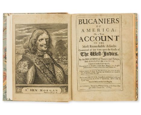
Pirates.- Exquemelin (Alexandre Olivier) Bucaniers of America: Or, a True Account of the Most Remarkable Assaults Committed of late Years upon the Coasts of the West-Indies, by the Bucaniers of Jamaica and Tortuga, 3 parts in 1, second edition, engraved portrait frontispiece, 3 portraits, a map of Panama and 4 plates (2 folding), 1 portrait with small ink stains, some staining and spotting, lightly browned, bookplate of Robert J. Hayhurst, modern calf-backed marbled boards, small 4to, printed for William Crooke at the Green Dragon without Temple Bar, 1684.⁂ One of the most popular and widely imitated of the accounts of piracy in the Americas. The lives of the buccaneers included in the work were liberally embellished to such an extent that Captain Morgan, one of the most notorious of those featured, successfully sued for slander and was awarded £200.
Lot 220
South America.- Depons (Francois) Travels in South America, 2 vol., first English edition, half-titles, folding engraved map (foxed), contemporary calf, stamped in gilt and blind, [Sabin 19643], 8vo, 1807.⁂ Fine copy of this important account of Venezuela, translated from the French, partially by Washington Irving.
Lot 184
Africa.- Burchell (William J.) Travels in the Interior of Southern Africa, 2 vol., first edition, 20 hand-coloured aquatint plates, some folding, wood-engraved illustrations, folding hand-coloured engraved map linen-backed and preserved separately, some foxing and light offsetting, lacking half-titles and errata slip, without the "Hints to immigration" sometimes found at end of vol.1, contemporary green half morocco over marbled boards, spines gilt, slightly rubbed and repaired, cloth slip-case, map in separate modern half morocco drop-back box, [Abbey, Travel 327; Tooley 116; Mendelssohn 1:224], 4to, 1822. (3)⁂ "The most valuable and accurate work on South Africa published up to the first quarter of the nineteenth century...the illustrations are characterized by great beauty and accuracy." (Mendelssohn)
Lot 55
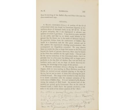
British Arctic Expedition of 1875-76.- Fulford (Reginald Baldwin, Naval Officer and Arctic Explorer, 1851-86).- Nares (Sir George S., Captain) Narrative of a Voyage to the Polar Sea, first edition, vol. II only, Reginald Fulford's copy with two autograph annotations in pencil on pages 82 Chapter III and 197 Appendix No. II and his "Bear Up" bookplate on front pastedown, photographs and illustrations, folding map, half-title, publisher's catalogue at end, some foxing and browning, original cloth, gilt spine, edges uncut, 8vo, 1878.⁂ First annotation a comment by Fulford on a passage by Nares recording Fulford's arrival at Discovery Bay with the news of Lieutenant Beaumont's arduous journey to Polaris Bay. "Two deaths had occurred - that of James Hand... and of Charles Paul... both of whom, carried on sledges, had lingered just long enough once more to sight their Arctic home before their spirits were called away." Fulford comments in margin, "I never said anything of the kind."Second note in the Appendix notes on the Narwhal, "One of the (Monodon monoceros) was killed by a party of officers from 'Discovery' with a harpoon gun this was a female specimen & had a most perfect tooth now in the possession of RB Fulford."
Lot 217
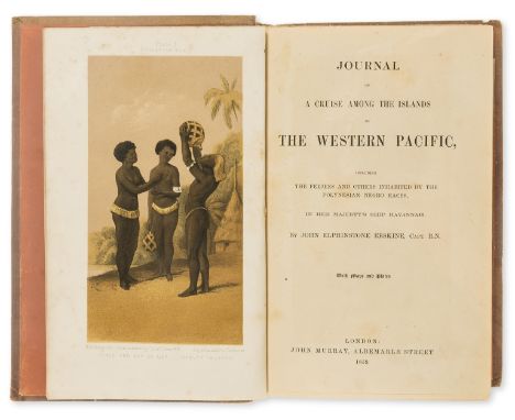
Oceania.- Erskine (John Elphinstone) Journal of a Cruise among the Islands of the Western Pacific, first edition, folding engraved map with repaired tear, 4 chromolithograph and 3 wood-engraved plates, illustrations, 32pp. publisher's catalogue at end, errata slip after list of plates, original pictorial cloth, gilt, recased, spine faded, covers partially sunned, [Abbey, Travel 602; Hill 568], 8vo, 1853.⁂ Erskine set off from Russell in New Zealand and visited Savage Island, Samoa, Tonga, Fiji, the New Hebrides and New Caledonia.

Lot 908
W. Watkins after Thomas H. Shepherd - 'St Mary, Aldermary', 'St MIchaels, Cornhill', coloured book plates 4.25" x 6"; together with a large collection of various other bookplates and signed etchings depicting scenes in Bruges, others depicting the courtyard of Old 'Tattersall's', a later coloured map of Northamptonshire, engraved for Dugdales England and Wales and finally a signed black and white woodcut print by George Soper numbered 6/50, 5.75" x 8.25", other later coloured reproductions after the work of David Shepherd, various sizes (a collection)
Lot 715
Robert Morden (1650-1703) - 'The County of Monmouth', inscribed within a decorative cartouche, hand coloured engraved map, 14" x 16.75" - *Provenance The Steps Gallery, 15, Christmas Steps, Bristol, BS1 5BS, 11th July 1990 cost price £90; together with two further small road maps by Eman Bowen, 'Bath to Chippenham' and 'Chippenham to Hungerford' (3)

Lot 376
A collection of modern history works on colonial ears of 19th century , Joan Blaeu, Atlas Major of 1655, Scotia & Hibernia, two volume set published in slip case, R A Sleton et al, The Vinland Map and The Tatat Relation, new edition in dust cover published 1995, together with other works on maps and cartography We are unable to do condition reports on our Interiors Sale

Lot 179
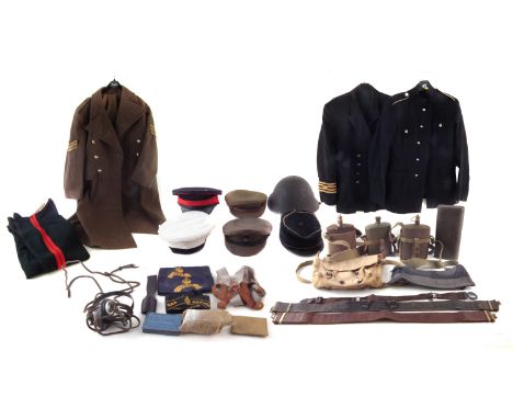
Collection of uniforms and caps webbing, to include a 1951 pattern 52 dated size 6 great coat, size 18 dress trousers, Cheshire regiment size 22 dress jacket, Navy jacket (no size) five caps (one with Gurkha Rifles badge) and a helmet, three water canteens, map case, canvas bag, two webbing belts and Boy Scouts belt, garters, Sullivans patent headphone set, pin case, Anti Gas ointment tin, field dressing set, War Damage committee band and two Civil Defence bands, and a leather frog.


Lot 540
INGRAM, The Revd J, The Saxon Chronicle with an English Translation and Notes, Critical and Explanatory, London 1823, Longman, Hurst, Rees, Orme and Brown with 3 fold map, vellum boards, 4to. (278 x 226mm) plus CONYBEARE, John Josias & William Daniel, Illustrations of Anglo-Saxon Poetry, Harding and Lepard, Pall Mall London 1826. 4to. (285 x 226mm), full tooled calf with armorial device and rebound spine, Eric Gerald Stanley b/p (2)

Lot 526
LAMBARDE, William (1536-1601) English Antiquarian, Archaimonia, Sive de Priscis Anglorum Legibus Libri... John Day, London 1568 with folding map of the Seven Kingdoms of Anglo Saxon Britain attributed to Lawrence Nowell, corrections to the translation thought to be in Lambord's hand see Fo. 26, later bound in marble boards with tooled calf spine entitled Anglo Saxon Laws 1568. 4to. (195 x 145mm), Eric Gerald Stanley b/p
Lot 637
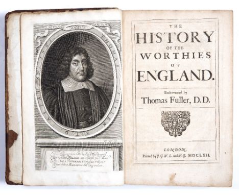
FULLER, Thomas, The Church-History of Britain from the Birth of Jesus Christ until MDCXLVII, London 1655, John Williams, folding map of Cambridge and other plates, full calf, restored spine. Fo. (345 x 230mm) plus FULLER, Thomas, The History of The Worthies of England, London 1662, with portrait engraving by D Loggin. Fo. (340 x 220mm), full brown leather, faded spine, bumps, stains, sold as found, Eric Gerald Stanley b/ps (2)
Lot 585
SOMNER, William, Julii Caesaris Portus Iccius with portrait engraving and fold out map by Edmund Gibson, Oxford 1694, contemporary calf (165 x 110mm) plus SOMNER, William, 'A Treatise of the Roman Ports and Forts in Kent' with portrait engraving Oxford 1693, full tooled calf (174 x 110mm) plus WILKES, J, Printer and Publisher, 'The History and Antiquities of Winchester...' 2 vols. with 13 plates 1773, full brown calf, restored spines, red title, foxing, bumps etc., (180 x 110mm) (4)
Lot 553
BARRINGTON, Daines, English Lawyer, Antiquary and Naturalist, Miscellanies including The History of The Gwedir Family by Sir John Wynne with Portrait, printed in London by J Nichols 1781. A collection of essays by Barrington including Mozart (with portrait engraving) on the Possibility of Reaching the North Pole, Natural History, Journal of a Voyage in 1775 by Maurelle to explore the Coast of America, with map, plus genealogical tables and map of Europe, 4to. (280 x 225mm), marbled end papers and edges, half tooled calf with double black titles and hatched red cloth (NB: A pencil note states that this book was bought at Sotheby's Chester, October 1980, Library at Wynne Family

Lot 544
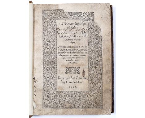
LAMBARD, William, A Perambulation of Kent, 2nd Ed, the damaged title page with typographic border, full page map of Heptarchia and with dedication to M Thomas Wotton Esq. printed in London by Edmund Bollifant 1596, full calf, gilt tooled and banded spine with red label. 4to. (190 x 140mm), armorial b/p and Eric Gerald Stanley b/p


Lot 574
MAGNUS, Johannes (1488-1544) Archbishop of Uppsala Sweden and Historian Gothorum Sueonumque Historia printed by Michael Isengrin Basle 1558 with Palma Ising printers device on title page, map of Scandinavia on p.17. dedication and appendix. 8vo. (190 x 140mm). incl. contemporary, embossed leather binding with handwritten title, library stamp, armorial b/p and Eric Gerald Stanley b/p


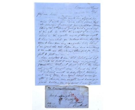
Lot 943
A MANUSCRIPT LETTER on blue paper with envelope dated 22nd April 1857 by Henry Waddington in Chunar, Uttar Pradesh, India to his mother in Whitby three weeks before the Indian Mutiny began on the 10th May 1857, with transcript and map, plus a contemporary hand-drawn map showing how the Relief of the Lucknow Residency was achieved by Lt. Gen. Colin Campbell in November 1857 plus FORBES-MITCHELL, William, The Relief of Lucknow, Folio Society, London 1962, blue cloth (5)
-
109198 item(s)/page