We found 109182 price guide item(s) matching your search
There are 109182 lots that match your search criteria. Subscribe now to get instant access to the full price guide service.
Click here to subscribe- List
- Grid
-
109182 item(s)/page


Lot 358
A Raven bar and Well of Souls Staff of Ra headpiece from Steven Spielberg's Raiders of the Lost Ark. A key plot point in the film, Indiana Jones (Harrison Ford) used the headpiece in the Map Room at Tanis to reveal the location of the Well of Souls, the resting place of the Ark of the Covenant.Two versions of the headpiece appear in the film. The first version was seen in the Raven Bar sequence and inside the Well of the Souls. It features simple detailing on the headpiece's feathered bird, and smaller characters around the border of the headpiece. This was the first version made by the in-house production team. The second version was constructed by an outside jeweler specifically for insert shots and features a more-detailed bird sculpture and larger characters around the edge, so that they were more obviously text characters on screen. The simpler 'Raven bar' style headpieces were used for the majority of live-action filmingThis 'Raven bar' style headpiece was acquired directly from a close family friend of the film's Construction Manager Bill Welch. The circular headpiece is fabricated from resin, and features a plastic, amber colored crystal "eye" adorns one side. The lot features a metallic goldtone finish, and a chain-like detailing around the perimeter. A slot is situated at the bottom where the piece was attached to the top of the wooden staff.The amber crystal is missing from one side and the headpiece displays a worn finish, with its color altered from age in some areas. Bill Welch's family has written a letter of authenticity detailing the history of the piece, which is included. Also included is a letter from the family friend of Bill Welch who was gifted the piece by Welch in 1990, which states in part "During this visit Bill [Welch] gifted my family the headpiece for the Staff of Ra, telling us it was the one used on the staff in the film." This is believed to be the only 'Raven bar' style headpiece ever offered at auction.Dimensions: 3 1/4" x 3 1/4" x 1/4" (8.5 cm x 8.5 cm x 1 cm)Estimate: $100,000 - 200,000

Lot 420
A park brochure from Steven Spielberg's sci-fi adventure Jurassic Park. The park brochures appeared in the film at various locations, including the Visitor Centre and the Ford Explorer tour vehicles.This double-sided paper brochure features a printed map of Jurassic Park on one side which pinpoints different sites on the island, including the Visitor Centre, helipad, electric fences, and dinosaur enclosures. The reverse shows a printed drawing of the park gates, with general information including a section in Japanese, a Kodak Film advertisement and a mountain terrain photograph that forms the front cover of the brochure when folded.The brochure has been intentionally distressed for the production and has been folded horizontally in the middle.Dimensions (closed): 8 1/4" x 4" (21 cm x 9.5 cm)Estimate: $3,000 - 5,000

Lot 766
A dinosaur input device D.I.D. Warrior Bug stop-motion armature from the production of Paul Verhoeven's sci-fi satire Starship Troopers. The Dinosaur Input Device, or D.I.D., takes its name from Jurassic Park, the film the technology was developed for. It enabled traditional stop-motion animators to produce computer animation without learning animation software programs.Digital sensors allow the armature to function as an animation capture device while the physical piece is manipulated by hand. This lot comes from the collection of Tippett, who used the device to map the movement of CG Bugs, including the giant Warriors, and was later nominated for an Academy Award for his work. This Warrior Bug D.I.D. features a metal and cast resin armature hand-painted chrometone, wired throughout with numbered motion sensors, and mounted with a steel pole to a wood display base painted gray. It exhibits minor signs of use, such as miscellaneous paint stains throughout, but remains in excellent overall condition. Includes a letter of authenticity from Phil Tippett. Dimensions: 14" x 14" x 17" (35.75 cm x 35.75 cm x 43.25 cm)Contains electronics; see electronics notice in the Buyer's GuideEstimate: $6,000 - 8,000

Lot 791
A storyboard folder from James Cameron's sci-fi sequel Terminator 2: Judgment Day. Storyboards are used to visually map out the film during the pre-production process. The folder is labeled "volume one" and features a complete set of storyboards from the beginning of the film up to the point when Cyberdyne explodes. The printed storyboards are divided into different labeled scenes (e.g. "Sarah's Nightmare #1) and are separated with orange sheets of paper.The folder has minor wear from production use and age, including some dark staining on the inside cover of the folder.Dimensions: 11 1/2" x 11" x 3 1/4" (29.5 cm x 28 cm x 6 cm)Estimate: $600 - 800


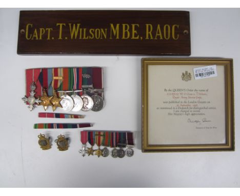
Lot 202
A Post War M.B.E. group of seven to Captain T.Wilson, Royal Army Service Corps,The Most Excellent Order of the British Empire, 2nd type Military Division; 1939-1945 Star; Africa Star with 8th Army bar; Defence Medal; War Medal; General Service Medal 1918-62, one bar, Cyprus with M.I.D. Oakleaf (S/2148125 W.O.CL.2. T.Wilson R.A.S.C.); Army Long Service and Good Conduct, E.II.R. (S/2148125 W.O.CL.2. T.Wilson. R.A.S.C.). Court mounted as worn, with corresponding miniatures. Good very fine. (Lot)Footnotes:M.B.E. London Gazette 1.1.1966.M.I.D. London Gazette 30.9.1958.The lot comes with an assortment of items comprising: Certificate for the M.B.E. (framed and glazed), Certificate for the M.I.D. (framed and glazed), Warrants dated 16.3.1955 & 16.11.1965 box for the MBE, newspapers for 1.1.1966 (Times), 8.1.1966 (West Lancashire Evening Gazette), quantity of photographs, a presentation pen and calendar set, silk map, silver and Wedgwood ashtrays, cloth patches, nylon map, wooden door plaque.For further information on this lot please visit Bonhams.com
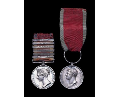
Lot 206
Pair to Lieutenant General A.T.Maclean, 13th Light Dragoons,Military General Service 1793-1814, six bars, Albuhera, Vittoria, Pyrenees, Nivelle, Nive, Orthes (A.T.Maclean, Lieut 13th Lt Dragns); Waterloo 1815, with steel clip and ring suspension (Allan T. Maclean, Lieut. 13th Light Dragoons.). Some light contact marks, otherwise very fine. (Lot)Footnotes:The lot comes with original documentation as follows:Warrant for Captain dated 23.12.1818Warrant for Major dated 29.10.1830.Warrant for Lieutenant Colonel dated 4.9.1834.Warrant for Lieutenant Colonel dated 7th January 1842Warrant for Colonel dated 17th March 1847.Warrant for Major General dated 10th July 1854.Warrant for Colonel of 14th Light Dragoons dated 8th June 1862.Warrant for Major General dated 8th June 1862.Warrant for Lieutenant General dated 8th June 1862.A letter from Horse Guards dated 28th March 1842 asking if he would like to proceed to India with the 9th Light Dragoons at Lieutenant Colonel.A birth certificate for his daughter A.A.M.Maclean 24th October 1849.A letter dated 12th May 1858 approving him to receive the Grant for Distinguished and Meritorious Service an allowance of £100 per annum from the 22nd March of March last, in envelope.A copy of his will dated 24th June 1867. A further Will from 1867 and Probate document dated 14th January 1869.A letter addressed to The Baroness de Pallandt (daughter of the above) with notes relating to his Waterloo service.A mid 19th Century map of Northern and Western Asia.Two Shoulder belt plates, a Scottish clan badge and a shooting medal.Lieutenant General Allan Thomas Maclean was born in Pennycross, Isle of Mull, Argyllshire, Scotland on 1 May 1793 to Archibald MacLean and Alicia MacLean. He became an Ensign with the 2nd West India Regiment without purchase on the 4th January 1810. He then became Cornet with the 13th Light Dragoons on the 23rd August 1810 again without purchase. Lieutenant 11th July 1811 by purchase. Captain 23rd December 1818 by purchase. Major 29th October 1830 without purchase. Lieutenant Colonel 11th July 1834 without purchase. He became Half Pay with the 13th Light Dragoons 31st May 1860. Allan Thomas Maclean married Agnes Lisle Robertson Forlong in 1843 and had 3 children. He died on the 9th December 1868 at 3 Oxford Square, London.The 13th Light Dragoons sailed for Lisbon in February 1810 for service in the Peninsular War. It took part in the Battle of Campo Maior on the Spanish-Portuguese border on 25 March 1811 in a clash that occurred between British and Portuguese cavalry, under Robert Ballard Long, and a force of French infantry and cavalry under General Latour-Maubourg. The regiment, two and a half squadrons strong, led by Colonel Michael Head, charged and routed a superior French cavalry force of no less than six squadrons. The regiment, with two Portuguese squadrons, then went on to pursue the French for seven miles to the outskirts of Badajoz. The report reaching Lord Wellington seems to have glossed over the epic quality of the charge and emphasised the overlong pursuit. After receiving Marshal Beresford's report, Wellington issued a particularly harsh reprimand to the regiment calling them 'a rabble' and threatening to remove their horses from them and send the regiment to do duty at Lisbon. The officers of the regiment then wrote a collective letter to Wellington detailing the particulars of the action. Wellington is reported as saying that had he known the full facts he would never have issued the reprimand. The historian Sir John Fortescue wrote, 'Of the performance of Thirteenth, who did not exceed two hundred men, in defeating twice or thrice their numbers single-handed, it is difficult to speak too highly.'The regiment formed part of Beresford's Allied-Spanish Army at the Battle of Albuera on 16 May 1811. The French army, commanded by Marshal Jean-de-Dieu Soult, Duc de Dalmatie, was attempting to relieve the French garrison of the border fortress of Badajoz. Only after bloody and fierce fighting, and the steadfastness of the British infantry, did the allies carry the day. The regiment, which was unbrigaded, formed part of the cavalry force commanded initially by Brigadier Robert Ballard Long and, later in the battle, by Major General Sir William Lumley.The regiment also saw action at the Battle of Arroyo dos Molinos in October 1811, at the Siege of Badajoz in March 1812 and, as part of the 2nd Brigade under Colonel Colquohon Grant, at the Battle of Vitoria in June 1813. The regiment advanced into France and fought at the Battle of the Nive in December 1813, at the Battle of Orthez in February 1814 and at the Battle of Toulouse in April 1814.The Battle of WaterlooThe regiment, commanded by Lieutenant-Colonel Shapland Boyse and forming part of the 7th Cavalry Brigade, but operationally attached to the 5th Cavalry Brigade, next took part in the Battle of Waterloo in June 1815. The regiment charged repeatedly during the day and completely routed a square of French infantry. An officer of the 13th wrote:Our last and most brilliant charge, was at the moment that Lord Hill, perceiving the movement of the Prussian army, and finding the French Imperial Guard on the point of forcing a part of the British position, cried out, - 'Drive them back, 13th!' such an order from such a man, could not be misconstrued, and it was punctually obeyed.For further information on this lot please visit Bonhams.com

Lot 81
A collection of WW2 and later Tissue and Silk Escape Maps,Tissue map of Yugoslavia and Southern Italy (WW2). Silk maps: Lower France and Spain- Northern France and Belgium (WW2); Norway Sweden Finland U.S.S.R. (Post WW2); Rasht (1952); S.Japan 44/V with N.Japan 44/W; Tunis/Marseille (1953); Roma-Sarajevo Tunis-Palermo (1953); Stockholm-Riga Oslo-Stockholm (1951); Ivanovo/Moskva 1952 (3). In unissued condition. (13)For further information on this lot please visit Bonhams.com

Lot 82
A collection of WW2 and later Tissue and Silk Escape Maps,Tissue map of Yugoslavia and Southern Italy (WW2). Silk maps: Lower France and Spain- Northern France and Belgium (WW2); Norway Sweden Finland U.S.S.R. (Post WW2); Rasht (1952); S.Japan 44/V with N.Japan 44/W; Tunis/Marseille (1953); Roma-Sarajevo Tunis-Palermo (1953); Stockholm-Riga Oslo-Stockholm (1951); Ivanovo/Moskva 1952 (3); Burma Siam French Indo China China (1950's). In unissued condition. (14)For further information on this lot please visit Bonhams.com
Lot 97
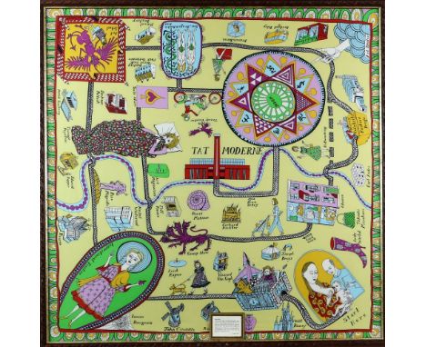
Grayson Perry silk scarf, with plaque stating 'In the second world war pilots were given maps printed on silk to help them escape if they were shot down over enemy territory. This scarf is a social and cultural map to help aspiring artists navigate the hostile territory on their way to being accepted by the establishment. Many famous artists who can help them live along the route', framed and glazed, from the Tate shop, 81 x 81cm


Lot 226
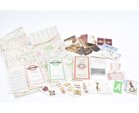
London Transport Underground Maps and various Cigarette Cards, Maps, Central Area No 5 1937 (poor), Central Buses 1968, Green Line Coach Routes 1963 and a part Green Line map, Amendment slip for Trolleybuses in Central Area dated 1957, P-F, Wills The Boyhood of Raleigh, The Laughing Cavalier and The Toast Famous Picture cards (neither set complete), Wills Railway Engines and many others, generally F-G (qty)


Lot 2208
John Speed (British 1552-1629) - Hand coloured engraved map of Kent sold by George Humble, 42 x 54.5cm approx visible sheet size, together with a coloured map of Kent showing the Battle of Britain locations 1940-1941, various late 18th and 19th century topographical prints and engravings including a view of the Royal Hospital at Chelsea, engraved by T Bowles, 29.5 x 43cm, an engraving of a view of Westminster Bridge, by Parr, published 1794 by Laurie & Whittle, 26 x 39.5cm approx visible sheet size, etc, mostly framed (a collection)


Lot 360
Thomas Rudge - The History of Antiquities of Gloucester, illustrations and map, leather bound, 1811; County Curiosities or a new description of Gloucestershire leather bound, illustrated, 1757; Moule - Gloucestershire (County Section Only) with map c.1830; Joseph Nightingale - Gloucestershire Topography (County Section Only) with hand coloured map, 1816 (4)
Lot 364
G A William - Williams New Guide to Cheltenham, c.1825 with map and illustrations; Alfred Ellis - The Landholders of Gloucestershire named in Domesday Book 1086-1880 (not published); Charles Taylor - An Analysis of the Domesday Survey of Gloucestershire, 1889; Roland Austin, Some Gloucestershire Books and Their Writers - 1911, Gloucestershire (I county only) with map by Morden; S Lyson - Section only Account of further Discoveries at Bignor, Great Witcombe, with plan, c.1820 (6)


Lot 414
ASSORTED PRINTS to include two Boris O'Klein prints of dogs, a pears print of a man carving a ham, two vintage prints depicting stags, reproduction Cadburys poster, photograph of an aircraft carrier with Hunter aircraft on the deck, topographical prints of Tamworth, map of Staffordshire etc (box and loose)

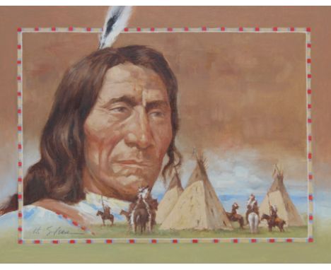
Lot 120
Hodges Soileau (American, B. 1943) "Red Cloud" Signed lower middle. Original Oil painting on Canvas laid on Foam Board. Provenance: Collection of James A. Helzer (1946-2008), Founder of Unicover Corporation. This painting was published on the Fleetwood First Day of Issue Maximum Card for the U.S. 10c Red Cloud stamp issued on August 15, 1987. Born in 1822 on Blue Creek in Nebraska, Red Cloud earned a reputation as a warrior, diplomat and leader. Described as a natural born gentleman, he led an independent band in the 1860's, and was eventually accepted as leader of the Oglala Sioux -- the largest Teton Sioux tribe. Throughout this period the Oglala dominated the rich Powder River hunting grounds of Wyoming and Montana. Meanwhile, as the Civil War raged eastward, John Bozeman was sent to map a trail through Oglala territory to the Montana goldfields. Red Cloud strongly opposed the route and the three forts built along the trail. He kept relentless pressure on the government and the forts until he succeeded in forcing their abandonment. He won both victory and peace with the treaty he signed on November 6, 1868. In his later years, Red Cloud continued to lead the Oglalas, and on October 7, 1878 he established the Sioux Agency. Blind and ailing, he died December 10, 1909. Image Size: 10.25 x 13.25 in. Overall Size: 13.25 x 16.25 in. Unframed. (B11202)


Lot 1058
A mixed lot to include tin plate wind up Island ferry and Harbour tug, merchant shipping brass buttons, Manchester Liners ashtray, small brass bell, 2 small pulleys, Dunston mug, shipping theme books, map of Ireland, coloured engraving print Roman road to Bramham 36 w x 22 h and a photo print Alexandra Dock, Hull.


-
109182 item(s)/page