We found 109182 price guide item(s) matching your search
There are 109182 lots that match your search criteria. Subscribe now to get instant access to the full price guide service.
Click here to subscribe- List
- Grid
-
109182 item(s)/page


Lot 211
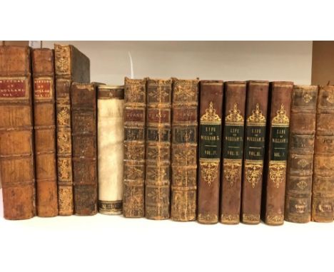
"The History of Galloway from the earliest period to the present time"In two volumes, with fold out map of Kirkcudbrightshire, published by John Nicholson, 1841, bound in half black calf with gilt lettering, Agnew (Sir Andrew), "The Hereditary Sheriff's of Galloway", two volumes, published by David Douglas, Edinburgh 1893, bound in brown cloth with gilt decoration, further books to include "The History of Scotland" by JH Burton, books on Robert Burns etc. (46)
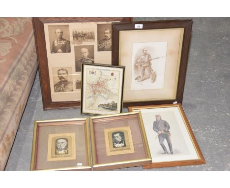
Lot 158
A framed picture of British Commanders in South Africa during the Boer WarAlong with further black and white print of a Boer War soldier titled 'A gentleman in khaki', Vanity Fair print of 'Bobs', two embroidered pictures of The Rt Hon W. E. Gladstone and the Late Earl of Beaconsfield and a map of Hereford (6)


Lot 395
CHAMBERLAIN, Henry, History and Survey of the Cities of London and Westminster, London 1769, folio, calf, rebacked raised bands, new endpapers, frontisplate, 64 plates and two maps, margins of frontisplate repaired, loss of lower margin on one plate, map of London frayed around edges, map of area 20 miles around London is damaged with approx 15% loss (1)Cover secure.Has been re-lined.Pages yellowed.Some foxing and staining/water damage – more so to frontispiece


Lot 1152
Middlesbrough-Guisbrough Railway Map showing the land of Revd. James Park and the proposed line of the railway, hand-drawn and hand-coloured in outline, together with a copy of the conveyancing of the land shown in the map, dated March 1854. The land was alongside the Marton Hall Estate, Middlesbrough, which was purchased by the Bolckow family in 1855. Together with memorandum of agreement relating to the North British Railway Company
Lot 1132
A map illustrating Storrs Hall in the county of Lancaster surveyed 1722, signed Thomas Buttle; together with a plan of an estate called Storrs Hall situated in the townships of Arkholme & Gressingham and parishes Melling and Lancaster the property of Rev'd Henry Asker, 1846; and various other maps and architectural drawings relating to Storrs Hall, Bainsbeck House, and surrounding areas, hand-coloured in outline and wash and with annotations marking owners, rents owned, mortgaged lands etc

Lot 1141
Maps including: Bowen, West Riding, 18thc; Owen and Bowen Three road ribbon maps showing Lancaster, Burton and Kendal. 18th c; Grose, Bedfordshire. 1783. All framed and glazed. Ogilby, John Britannia Volume the First. Alexander Duckham, 1939. Oblong 4to; decorative title, coloured frontis. map, 100 coloured map plates. Facsimile of Ogilby's 1675 atlas.

Lot 1131
A small quantity of indentures and conveyancing, 18th century and later, some relating to John Hall, Kirkby Lonsdale innkeeper; together with a plan of river Lune from Lunes Bridge to the North End of F F Pearsons Estate and Mr Pearsons land in the township of Arkholme; and another map illustrating the river Lune

Lot 1120
A collection of maps of Westmoreland including: Saxton likely the 1637 edition (with plate number in lower left corner); Cary, John 1787. Archer, J. c.1850. Framed. with 8 others, unframed. And other county maps including: Smith, G. A Map of the Countries Adjacent to Carlisle, [1746]; Morden Nottinghamshire; Wallis, J. Lancashire. 1812. Framed. With 13 others, unframed


Lot 297
Star Wars - a lot to include two boxes of empty Star Wars toys related boxes to include Action Fleet vehicles, an original 1980's action figure card pack packing's, a Star Wars 20th anniversary collector's edition calendar, A2D2 figure, also included in the lot is Lord of the Rings a map of middle Earth measuring 60 cm x 80 cm (3).


Lot 202
An interesting framed Welsh drawing incorporating a map of North Wales in the form of a walking female & with town names inscribed, 33 x 25cms Condition reports are provided on request by email only for this type of auction, otherwise purchase 'as seen'. Condition reports done week commencing January 7th.

Lot 504
An interesting early twentieth century linen back map of the Cardiff area, 76 x 99cms Condition reports are provided on request by email only for this type of auction, otherwise purchase 'as seen'. Condition reports done week commencing January 7th.There are lots of creases and a few small edge tears.There are no major holes or tears, there are a few water marks on the back.


Lot 88
Land rights & reform.- Healy (T.M.) Why there is an Irish land question and an Irish Land League, signed presentation copy from the author, ink number stamp to title, original cloth, gilt, rubbed, Dublin, 1881 § Scully (Vincent) Free Trade in Land explained, folding lithographed map, pencil notes to rear pastedown, original cloth, gilt, Dublin, 1854 § O'Neill (Henry) Ireland for the Irish: Practical, Peaceable, and Just Solution of the Irish Land Question. Dedicated to Lord Viscount Stanley, half-title, review f. at end, original cloth, gilt, 1868; and c. 20 others, Land rights & reform, including some reports, v.s. (c.23)⁂ An excellent selection of works on the Irish land question.


Lot 141
NO RESERVE Africa.- Du Chaillu (Paul B.) Explorations and Adventures in Equatorial Africa, second edition, A.Ls dated 1889 tipped-in to front free endpaper, folding frontispiece, plates and illustrations, 1 folding map, tears, repaired, cracked hinges, spotting, original cloth, rebacked with original spine partially laid down, a little rubbed, bumping to corners, [Hosken pp.52-53], 1861; and 2 others by the same, 8vo (3)

Lot 167
Ellis (William) The Farmer's Instructor..., half-title verso with publisher's advertisements, engraved frontispiece, woodcut head-pieces and initials, faint browning and finger soiling, [ESTC T108402], 1747 § Marshall (William) The Rural Economy of the Midland Counties..., 2 vol., [ESTC T207325], for J.Moore, Dublin, 1793 § [Young (Arthur)] The Farmer's Guide..., 2 vol., 10 engraved plates, 2 folding, vol.I publisher's catalogue [ESTC T56260], for W. Strahan & others, 1795 § Brown (Robert) General View of the Agriculture of the West Riding of Yorkshire..., engraved folding map [ESTC T40696], for James Watson, Edinburgh, 1799 § Banister (John) A Synopsis of Husbandry..., half-title, folding table, [ESTC T80368], for G.G. and J.Robinson, 1799, first editions, faint spotting or browning, first two contemporary calf or tree calf, others original wrappers or contemporary boards, third, fourth and fifth fore-edges uncut, also many ff. unopened, first two worn at extremities and with superficial splits to hinges, others marked or stained and with spines dessicated and a little friable, some loss; and 3 others, related, 8vo & small 4to (10)

Lot 138
Photograph Album.- Wagner.- Bayreuth Festival, 1931.- c.100 pasted-in views and portraits documenting a British couple's visit, with travel catalogues and brochures, postcards, tickets, maps, menus, wine lists, festival programmes, playbills, and cigarette cards, also syndicated portraits of Toscanini, Elmendorff, Friedrich Schorr, Rosalind von Schirach, Maria Müller, Gotthelf Pistor, Nanny Larsén-Todsen, and Lauritz Melchior, the last signed ?by Melchior, shots of the stage sets, sample of Gustav Mori's 1931 facsimile of Gutenberg's Erste Seite des Türkenkalendars, itinerary and hand-drawn map pasted in, ownership inscription to front pastedown, contemporary cloth, hinges pulling, a little worn, oblong 4to [1931].
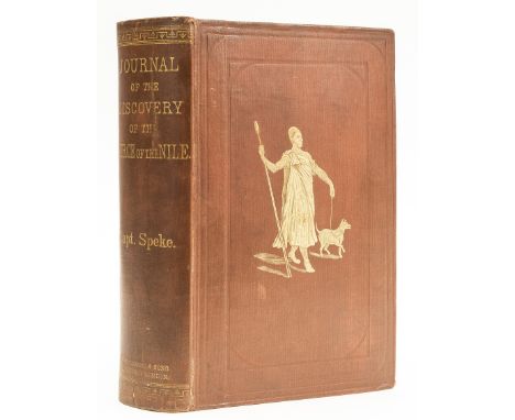
Lot 143
Africa.- Speke (John Hanning) Journal of the Discovery of the Source of the Nile, first edition, engraved portrait frontispiece, 2 lithographed maps (1 printed in red and blue and one folding and in pocket at end), further engraved portrait, 24 wood-engraved plates, wood-engraved illustrations, 34pp. publishers' catalogue at end, a few short splits at folds to folding map, repaired verso, some spotting, recased in original pictorial cloth, gilt, corners little worn, rubbed, [Czech p.151], 8vo, Edinburgh and London, 1865.⁂ 'One of the cornerstone books of African exploration' (Czech).
Lot 263
Netherlands history, 8vo and 12mo. The History of the Republick of Holland..., 2 vols., London 1705, folding map and 16 portraits, panel calf; TORCY (Comte de) Memoires de ... pour servir a l'histoire des Negocations Depuis le Traite de Riswick.., in 3 vols. a la Haye 1757; Lettres et Negociations entre M. Jean de Witt.., 4 vols. Amsterdam 1725; KANE (R) Campaign of King William and the Duke of Marlborough.. 1689 to 1712. 2nd edition 1747, folding map and 17 plates; WITT (J de) The True Interest and Political Maxims of the Republick of Holland and West Friesland, in three parts. London 1702, portrait; few others, contemporary bindings in varying condition (19)
Lot 266
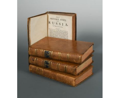
Russia - history. GORDON (A) The History of Peter the Great, in 2 vols., Aberdeen 1755, 8vo, 3 portraits, folding map, contemporary calf; [WEBER (F C)] The Present State of Russia, 2 vols., London 1723-22, 8vo, folding map and plan, contemporary calf; Life of Catharine II, 2nd edition, in 3 vols., 1798, 8vo, portrait, folding map (dust stained, foxed), worn half calf; 2 others (9)

Lot 331
History and topography, general literature. Victoria History series, Huntingdonshire, 3 vols., and Index, red cloth; BALL (Rev. C J) Light from the East. 1899, small 4to, plates, cloth; [HEY (Rebecca)] The Moral of Flowers, 2nd edition London 1835, 8vo, 24 hand coloured plates, endpapers stained, full morocco gilt by Robinson, spine ends worn; HUGHES (William) A Week's Tramp in Dickens-Land. London: Chapman & Hall, 1891, 8vo, illustrated, cloth gilt; WYLD (James) Map of the Central States of Europe, 1866, large coloured folding map, linen backed; etc

Lot 348
NORTH AMERICA. BELL (William Abraham) New Tracks in North America. First edition, 2 vols., London 1869, 8vo, folding map, lithographic plates (vol. I lacking 2 plates), author's inscription to Mrs Palmer, some edge tears, occasional added notes, recased in original cloth; BAILEY (James Napier) Sketches of indian Character... exhibited by the North American Indians. Leeds 1841, 8vo, 64pp. paper wrapper; DUNN (W) History of the Great Island, 1894, 8vo, half morocco; JACKSON (Rev. S) Alaska, 1880, 8vo, illustrated, green cloth; OUSLEY (C) Galveston in 1900, original cloth gilt; JONES (George) Tecumseh - Biography - Oration. London 1844, 8vo,slight foxing, original cloth (7)

Lot 38
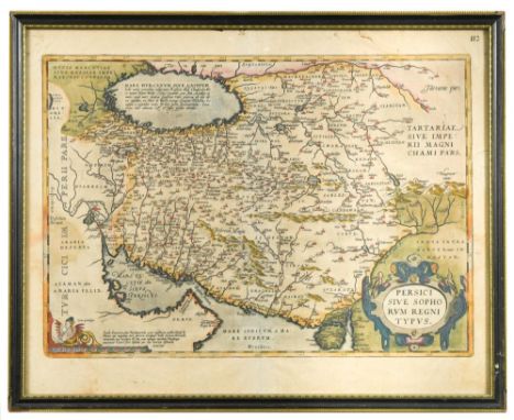
Abraham Ortelius. Persici sive Sophorum Regni Typus, engraved hand coloured map showing Iran, Afghanistan, Pakistan, the Caspian Sea and the north eastern tip of the Arabian Peninsula including United Arab Emirates and Oman, Spanish text verso, 42 x 53cm (sheet), a few edge tears and rather toned; and a map of Egypt by Tallis (2)


Lot 395
HUGHES (Rev. Griffith) The Natural History of Barbados, first edition 1750, folio, list of subscribers, double-page engraved map by Thomas Jefferys, 30 engraved plates by Bickham and Ehret, engraved head-pieces and woodcut decorations, Addenda and Index at end, general spotting and toning throughout, calf with wear to edges

Lot 399
MALTON (James) A Picturesque and Descriptive View of the City of Dublin, c.1811, oblong folio, with Dublin arms frontispiece, title, dedication, 2 plans, keyplate, and 25 aquatint plates of Dublin scenes (few watermarked 1811), few slight pencil marks to some margins, lacking the plan of Dublin by Faden; bound with SWINBURNE (H) Picturesque Tour through Spain, 1806, with frontispiece, map and 20 plates; and GMELIN (F) Dissertazioni di Tivoli e di Albano, 1816, 12 plates; also 13 engraved plates by Bartolozzi after Stothard bound at the front front board detached

Lot 40
C & J Greenwood Map of the County of Northumberland, coloured engraving 1831, by J & C Walker, 65 x 67cm; together with county maps for Hertforshire and Bedfordshire also by Greenwood (latter two are unframed); and a 'Corresponding' atlas by Sharpe, 1849, folio, 54 maps with outline colour, contents loose and chipped

Lot 403
NIEUHOFF (J) An Embassy from the East India Company to China, translated by John Ogilby, 2nd edition London 1673, folio, 17 (of 18) plates, illustrations in text, engraved title (with damaged margins) laid down, title and double page map chipped and also laid down, first 6 text leaves with repaired margins, some central leaves with worming at head of inner margin not affecting text, all in contemporary boards with good 20th century morocco reback


Lot 444
BRISSOT De WARVILLE (Jacques-Pierre) Nouveau Voyage dans les Etats-Unis, first edition, Paris 1791, 3 vols. 8vo, folding title, one title repaired, all rather toned, chipped spines; HOARE (Sir Richard Colt) A Classical Tour Through Italy and Sicily, in 2 vols. 2nd edition, 8vo, 1819, map frontispiece offset onto title, rebacked; [SHERER (J)] Scenes and Impressions in Egypt and in Italy. London 1824, 8vo, rebound (6)

Lot 463
SAVARY (C E) Lettres sur La Grece. Paris 1788, 8vo, folding map and plate, title browned, calf backed boards; LE BLOND (G) Elementos de Fortificacion. Madrid 1776, small 8vo, 20 folding plates, tree calf; CHARLEVOIX (Pierre Francois Xavier de) The History of Paraguay. Dublin 1769, 2 vols. 8vo, contemporary calf, head of spine chipped to vol. I; PFEIFFER (Ida) A Visit to Iceland, London 1852, 8vo, tinted title, frontispiece and plates, punblisher's blindstamped cloth (4)


![John Speed. Hartfordshire Described, engraved double page map (uncoloured), published by Sudbury and Humble [c.1630], 41 x 51](https://cdn.globalauctionplatform.com/a227e4d1-7fe6-47cc-8ad5-a9b900a5bba9/21c60dea-9142-44fb-a254-a9bd012381f3/468x382.jpg)

Lot 51
Two 18th century London maps. Thomas Kitchin, A Map of the Countries Thirty Miles Round London, engraving c.1773 with outline colour for Noorthouck's History of London, 53 x 55cm; Carrington Bowles, Bowles's new pocket plan of the cities of London and Westminster, with the Borough of Southwark, engraving 1788, some hand colouring, 46.5 x 92cm (loose with fold creases and some small edge tears)
-
109182 item(s)/page