We found 109182 price guide item(s) matching your search
There are 109182 lots that match your search criteria. Subscribe now to get instant access to the full price guide service.
Click here to subscribe- List
- Grid
-
109182 item(s)/page


Lot 319
MATTHAEUS SEUTTER & GOTTFRIED ROGG 'Africa Iuxta Navigationes et Observationes Recentissimas Aucta, Correcta et in sua Regna et Status Divisa in Lucem Edita' mid-18thC map of Africa with hand coloured detail and decorative engraved titlepiece, set in gilt frame Some damp marks and foxing, framed close to edges, minor fold marks

![Cary [John]: Cary's Traveller's Companion, or a Delineation of the Turnpike Roads of England and Wales, printed for G and J C](https://cdn.globalauctionplatform.com/ba887207-a978-4687-a8a1-a7c400fac508/e86f883d-b237-4290-f2c0-17f9ab647371/468x382.jpg)

![Dunston [G., M.I.M.E]: The Rivers of Axholme, with a History of the Navigable Rivers and Canals of the District, pub. A. Brow](https://cdn.globalauctionplatform.com/ba887207-a978-4687-a8a1-a7c400fac508/098d8803-f22e-4d7d-9fd1-8f59a037877f/468x382.jpg)
Lot 687
Dunston [G., M.I.M.E]: The Rivers of Axholme, with a History of the Navigable Rivers and Canals of the District, pub. A. Brown & Sons, London, 1909, four fold-out maps and plans, portrait frontis, green cloth; Bogg [Edmund]: The Old Kingdom of Elmet and the Ainsty of York, 1902, green cloth; Wilkinson [J]: Worthies, Families and Celebrities of Barnsley and District, first series, pub., Bemrose & Sons, London, gilt and black lined to red cloth; Rev. W. Parker Stamper (Vicar): Youlgrave, a Derbyshire Village, pub 1902, and a Collins Railway & Telegraph Map of Derbyshire. (5)
![Butler [Colonel Sir W.F. K.C.B.]: Campaign of the Cataracts, Being a Personal Narrative of The Great Nile Expedition of 1884-](https://cdn.globalauctionplatform.com/ba887207-a978-4687-a8a1-a7c400fac508/0c38f958-04d5-4ed5-8147-f8a85d8cf28e/468x382.jpg)
Lot 685
Butler [Colonel Sir W.F. K.C.B.]: Campaign of the Cataracts, Being a Personal Narrative of The Great Nile Expedition of 1884-5, pub. London, Sampson Low, Marston, Searle & Rivington, 1887, first edition, illus. by Lady Butler, folding map of the Nile from the Mediterranean to the Equitorial Lakes present, rebound half calf; Parry [Judge Edward Abbott: The Seven Lamps of Advocacy, pub. T. Fisher Unwin Ltd, 1923, half blue marbled boards. (2)

![Dugdale [Thomas]: Curiosities of Great Britain, England and Wales Delineated, pub. L. Tallis, London, Edinburgh and Dublin, v](https://cdn.globalauctionplatform.com/ba887207-a978-4687-a8a1-a7c400fac508/86ddd433-9d29-4431-b8f2-168f99675b38/468x382.jpg)
Lot 662
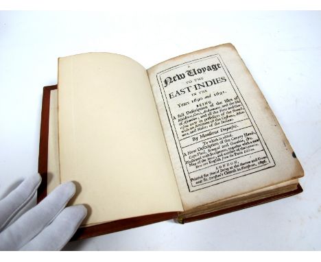
Monsieur Duquesne : A New Voyage to the East Indies in the Years 1690 and 1691, being a full description of the Isles of Maldives, Cocos, Andamans and the Isle of Ascension, and all the Forts and Garrisons now in possession of the French, with an account of the customs, manners and habits of the Indians, printed for Daniel Dring at the Harrow and Crown near St. Dunstan's Church in Fleet Street, 1696, first edition in English, five engraved plates and a fold-out map (map of India missing), rebound calf.


Lot 136
British Caribbean Territories P 7b Linzmayer B107d The British Caribbean Territories Eastern Group 1 Dollar 3 January 1956. Map of Caribbean at lower left portrait of Queen Elizabeth II at right on front. Signatures Lartigue - Blache-Fraser - Spence. Coats of arms of the various territories in all four corners on back. # P2-233157. UNC

Lot 141
British Caribbean Territories P 8b Linzmayer B108f The British Caribbean Territories Eastern Group 2 Dollars 2 January 1958. Map of Caribbean at left portrait of Queen Elizabeth II at right on front. Signatures Essex - Waterman - Williams. Coats of arms of the various territories in all four corners on back. # L2-581672. XF


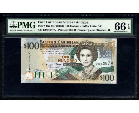
Lot 250
East Caribbean States P 46a Linzmayer B230a Eastern Caribbean Central Bank Antigua 100 Dollars (2003). Fish barcode for Antigua sea turtle at bottom Central Bank building at left center portrait of Queen Elizabeth II at right green-throated carib bird and rectangular foil flower patch at upper right on front. Signature Dwight Venner. Portrait of St. Lucian economist Sir William Arthur Lewis at left map of islands at center Central Bank headquarters building and fountain at right on back. # D 904087 A. PMG 66 EPQ Gem UNC


Lot 568
Ireland Republic Blake/Callaway LTN86R P 76ar MWR RC6a Central Bank of Ireland 10 Pounds 14 July 1993 REPLACEMENT. Dublin at center James Joyce at right on front. Signature Doyle - Cromien. Sculpted head representing Liffey River at left map in underprint on back. JJJ prefix replacement. # JJJ 131197. PCGS 66 PPQ Gem UNC


Lot 618
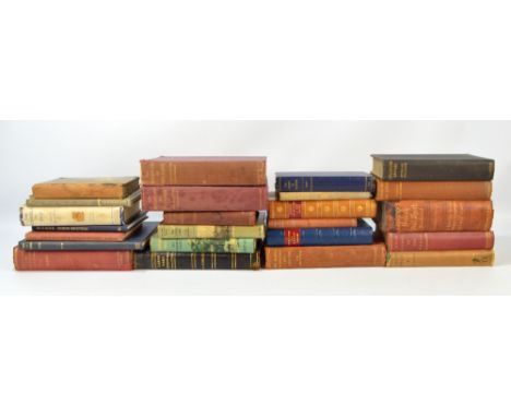
A collection of over twenty angling and hunting related books to include 'Waterside Sketches' by W. Senior ('Red Spinner'), Grant & Co, London 1875, 'Lake Ngami' by C.J. Andersson with coloured lithograph and engraved illustrations (lacking map), Hurst & Blackett, London 1856, 'Days And Nights With Indian Big Game' by A.E. Wardrop with monochrome illustrations, Macmillan & Co 1923, etc. CONDITION REPORT: 'Waterside Sketches' in contemporary boards with printed illustration to front and advertising to reverse, extensive deterioration, 'Lake Ngami' in contemporary cloth boards with fading and general wear, 'Indian Big Game' in contemporary cloth boards with gilt native scene to front, areas of spotting/foxing and wear to page edges throughout.
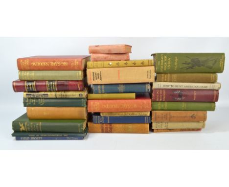
Lot 619
A collection of over twenty hunting and sporting related books to include 'The Jungle In Sunlight And Shadow' by F.W. Champion with monochrome printed illustrations, Chatto & Windus London, 'The Adventures Of An Elephant Hunter' by J. Sutherland with monochrome printed illustrations, Macmillan & Co, London 1912, 'The Diary Of A District Officer' by K. Bradley with map of Portuguese East Africa to front, George J. Harrap & Co London, 'Sporting Adventures In The Pacific' by Capt. W. R. Kennedy with monochrome engraved illustrations, London 1876, etc. CONDITION REPORT: 'The Jungle In Sunlight And Shadow' in contemporary cloth boards; The Adventures Of An Elephant Hunter in contemporary cloth and Morocco boards with gilt elephant to front; The Diary Of A District Officer in contemporary cloth boards; Sporting Adventures In The PacificBoards in contemporary Morocco, marbled and gilt tooled boards (realigned); generally faded/discoloured with fraying to edges, areas of spotting/foxing throughout and wear to page edges.

Lot 244
A collection of predominantly 1950s military training pamphlets, the majority related to various infantry platoon weapons, also 'Hints on Map Reading Instruction' 1943, and 'Manual of Military Intelligence' 1946, 'Uniforms and Insignia of the Soviet Army and Paramilitary Forces' 1955, 'East of Malta West of Suez' 1943, and 'Coastal Command'.
Lot 617
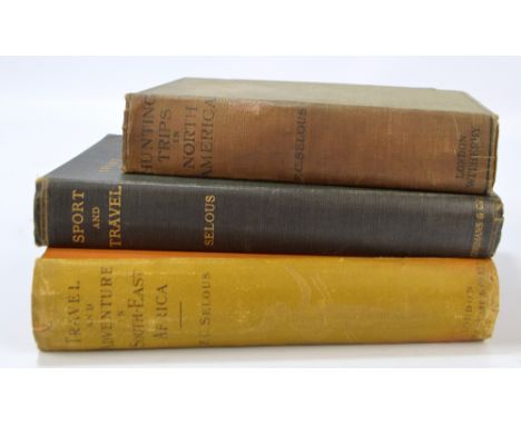
SELOUS, FREDERICK COURTENEY; three volumes comprising 'Travel and Adventure In South-East Africa', with numerous illustrations and fold out map, Rowland, Ward & Co, London 1893; 'Sport and Travel East and West' with numerous monochrome illustrations, Longmans, Green & Co, London 1900; 'Recent Hunting Trips In British North America' with numerous monochrome illustrations, popular edition, Witherby & Co, London 1909 (3). CONDITION REPORT: Travel and Adventure in South-East Africa in contemporary cloth boards with gilt lions to front; Sport and Travel East and West in contemporary cloth boards with gilt moose head to front; Recent Hunting Trips In British North America in contemporary cloth boards.Boards worn with fraying to edges and general discolouration, some foxing/spotting and wear to page edges.

-
109182 item(s)/page