We found 109198 price guide item(s) matching your search
There are 109198 lots that match your search criteria. Subscribe now to get instant access to the full price guide service.
Click here to subscribe- List
- Grid
-
109198 item(s)/page


Lot 807
Brannon (George). Vectis Scenery: or, a Series of 26 Well-known Views, Exhibiting the Picturesque Beauties, Local Peculiarities, and General Aspect of the Isle of Wight..., a New and Improved Edition..., Published by the engraver, Southampton, 1824, engraved map frontispiece, forty engraved plates, recent red half morocco gilt, oblong 4to


Lot 907
Furness interest. Cavendish (Lord George). The antiquities of Furness; or, an account of the Royal Abbey of St. Mary, in the vale of Nightshade, near Dalton in Furness, 1774, folding engraved map frontispiece, engraved plates, contemporary half calf, joints cracked, some wear, large 4to, together with Beck (Thomas Alcock), Annales Furnesienses, History and antiquities of the abbey of Furness, 1844, engraved & colour plates, contemporary morocco, rubbed, large 4to, plus seven other related, including Furness, past and present, by George Markham Tweddell & J. Richardson, 2 volumes, 1870-80, etc. (9)

Lot 462
BORODULIN, ALEXANDER (B. 1952) Map of Moscow with a Collection of Photographs, map signed, also further signed, stamped with the photographer's stamp and dated 1971 on the reverse. Collage with 16 gelatin silver prints laid on the offset printed map, 76.5 by 69 cm (map size). Photographs taken and printed c. late 1960s–1971. Provenance: Borodulin collection, Europe (stamp on the reverse). Exhibited: Alexander Borodulin, Manege, Moscow, 2009 (stamp on the reverse).


Lot 1161
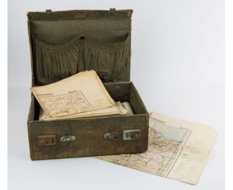
A near complete set of WW2 Luftwaffe 1:100,000 Invasion maps of Great Britain, (lacks no. 20 - Pembrokeshire - and 34 - London), each map with the text 'Sonderausgabe! Nur fur den Diensigebrauch!' (Special Edition For Official Use Only!), all folded, contained in a period crocodile effect carrying case., * These maps were produced just before the outbreak of war and were based on the Ordnance Survey ½in scale maps, enlarged to a scale of 1:100,000
Lot 727
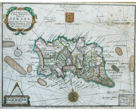
Philip Dumaresq and Thomas Lempriere, 'A New and Accurate Map of their Majesties Island of Jersey....', hand coloured engraved map with decorative title cartouche, scale with dividers, compass rose and Jersey Arms, c.1694, taken from the volume 'Caesarea - Or an Account of the Island of Jersey' by the Rev. Philip Falle, 11½ x 15in. (29.25 x 38cm.). * Condition: Some foxing, mainly to the right side. Lower right corner and text below lower margin poorly printed (offset type). 3in. repaired tear to right hand edge just below Castle Bank. Some ghost printing across surface of paper due to being folded for many years. Modern gilt frame with pale apricot mount.

Lot 728
Pieter van den Keere (Dutch, 17th century), a four part miniature engraved map of Holy Iland, Garnsey, Farne and Jarsey, hand coloured, c.1620, 3¼ x 4¾in. (8.2 x 12cm.). * Condition: Later hand colouring. Good condition overall. Border slightly faintly printed to top corners. Modern gilt frame with lined mount.
Lot 741
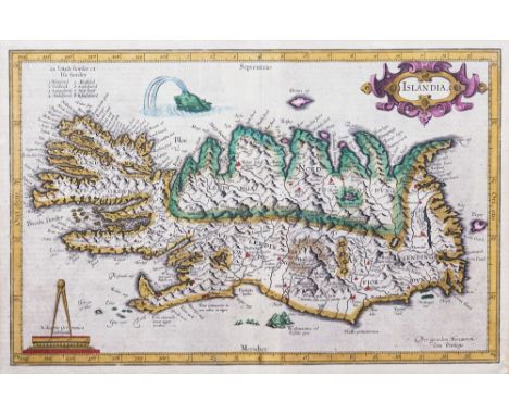
Gerard Mercator (1512-1594), Islandia, (Iceland), 1595 or later, hand coloured engraved map, title cartouche, scale surmounted by dividers, sea monster upper left, 11 x 17in. (28 x 43.5cm.), Latin text verso. * Condition: Repaired tear to centre bottom in margin of map, approx. 2in visible to text verso. Slight browning to edges at joint with mount of map. Small patch of restoration with retouch to corner of map to lower right corner - verso this is visible as a white patch on the paper. Three other smaller similar white patches visible verso but they are beneath the mount on map side of frame. Map has a few minor fox marks but clean overall. Text verso has some time stain marks throughout.

Lot 768
Berry, William, The History of the Island of Guernsey, part of the Ancient Duchy of Normandy, from the remotest period of antiquity to the year 1814, Containing an interesting account of the island; its government, civil, military, and ecclesiastical; peculiar privileges, customs, etc. with particulars of the neighbouring islands of Alderney, Serk, and Jersey', folding map and 29 engraved plates, published by Longman, Hurst, Ress, Orme and Brown, London 1815, in finely bound burr wood effect boards with centralised armorial of griffin's head beneath crown, the edges with a gilt elliptical chain border, spine with tooled gilt roundels and title on in gilt on red ox-blood leather, 4to., fine copy. * Condition: Some very minor foxing to first page. minor rub to top of spine showing velum. A very good copy.

Lot 815
Van Millingen, Alexander, 'Constantinople', pub. A. & C. Black, 1906, three quarter leather with mottled card boards, elaborate tooled leather and ridged spine with gilt titles, colour plates by Warwick Goble, fold out map to rear, final four pages advertising other available volumes. * Condition: Some minor scuffs to corners and spine.
Lot 833
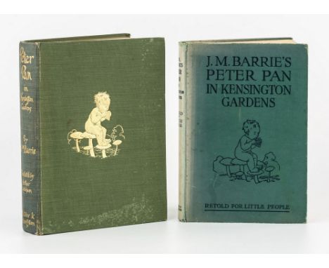
Barrie, J. M.; Rackham, Arthur (illustrator), 'Peter Pan in Kensington Gardens', Hodder and Stoughton, c.1910, olive cloth boards with gilt pictorial of pan pipe playing child on toadstools, double page map to inside front cover; together with a copy of the same title retold by May Byron with permission of the author, illust. Rackham, Hodder and Stoughton April 1948. (2) * Condition: First book loose in boards, fading to boards of Byron copy.

Lot 875
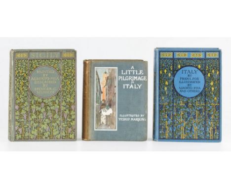
Musson, Spencer C., 'Sicily', pub. A. & C. Black, London 1911, olive cloth boards with vine decoration and gilt text, 312 pages, 48 tipped in colour plates, plus folding map at rear; together with two other volumes, 'Italy' by Frank Fox, A. & C. Black, 1918, blue cloth boards with vine decoration, illust. Alberto Pisa; and 'A Little Pilgrimage of Italy', illust. Yoshio Markino, Constable and Co. 1913, both with ex-libris pastedowns to first page. (3) * Condition: A Little Pilgrimage in poor condition, pastedown to first page of Fox edition.


Lot 1289
John Carey - "Carey's New Universal Atlas containing distinct maps of all the principle States and Kingdoms throughout the World", printed for J. Carey, Engraver and Map Seller, No. 181, near Norfolk Street, Strand, London 1808, and containing sixty coloured double page engravings (one volume - folio - fully bound in tooled calf)

Lot 378
John Speed (1552-1629) - Coloured engraving - "The Countie of Leinster with the Citie Dublin Described" - A Map of the county with plan of the City of Dubline to top right hand corner, 15ins x 20ins, sold by John Sudbury and George Humble in Popes-head Alley against the Exchange and thought to be from the 1627 edition of "The Prospect of the Most Famous Parts of the World" printed by John Dawson, and with English text to reverse (some reinforcing to lower part of fold), in ebonised and double sided glazed frame


Lot 388
James Collins (active 1690-1716) - Coloured engraving - "An Exact Prospect of the City of Rochester taken from Finsbery Windmill and A Prospect of Chatham Dock from same", 18.75ins x 26.5ins, a coloured engraving - "A Map of the Liberty, formerly called The Hundred of Rochester and of The Hundred of Larkfield", 19.25ins x 15ins, by Bayly, and after Braun & Hogenberg - Coloured engraving - "Visbia Gothorum", 14ins x 20ins (restrike), all framed and glazed

-
109198 item(s)/page