We found 109182 price guide item(s) matching your search

Refine your search

Year

Filter by Price Range
  • List
  • Grid
  • 109182 item(s)
    /page

Lot 138

A map of Staffordshire and Shropshire, inscribed to the border Jansson 1646, 19.5ins x 23ins

Lot 139

A map of Worcestershire by John Speede, 16ins x 20ins

Lot 178

A selection of pewter mugs and tankards, and jugs, together with a Shirehorse bridle, and a linen backed map of the Midlands by G.W. Bacon & Co.

Lot 367

A collection of pictures including a folding map of the South West of England, a watercolour of Oddicombe Beach by T. Weston, various Still Life and Landscape paintings including a still life of daffodils and tulips by Mavis Egerton, a Graham Clarke signed and numbered print titled 'Fruit and Veg' and an original oil on board of Port Quin, Cornwall (loose in frame) (10)

Lot 374

A number of framed pictures and prints to include an original pencil drawing of a cathedral, a map of Somerset and a Turner print, with a large square carved frame made The Modern Home, Bombay (11)

Lot 484

A 20th century table with 17th century map design to top, on square legs

Lot 338

Three framed prints of Newark, one Newark From The North Road, another reproduction map of Newark showing the redoubts, forts and fortifications of 1644, the other of St Mary Magdalene, Newark, Nottinghamshire, various sizes, all framed

Lot 354

A map of England by James Bradley, aged 11 years, pupil, at G, Roach's Academy, West-gate, Wakefield, pen and ink, 50cm x 46cm, oak Oxford frame

Lot 703

Advertising - a Stevens & Mcintosh, Leicester - business street map of Middletown, advertising border, 74cm x 82cm, late 19th Century (faults)

Lot 2657

A map measure and a plated pounce pot.

Lot 93

Domesday Book for Norfolk (Alecto Editions, 1000 copies printed); Camden's Britannia (lacking the maps); Adams Index Villaris (lacks map) and two others

Lot 396

A large early 20thC bound cloth map of Southend 151cm x 353cm

Lot 602

ANGLING, hardback edition of Where To Fish by H.D. Turing, pre-WWII, with numerous colour pages of flys and fold-out GB map, dj (small tears), G

Lot 71

PHILIP LEA 'A Map of Oxfordshire', double page engraving with decorative coats of arms to the sides, hand-coloured, 37 x 49cm

Lot 72

C GREENWOOD 'Map of the County of Middlesex from an actual survey made in the years 1818 and 1819', a set of four, one with engraved view of London taken from Buckingham House, published by G Pringle & C Greenwood, No. 50 Leicester Square, c. Oct 25 1819, each with quarter folds but framed, 65 x 68cm (4)

Lot 73

BLAEU 'The West Riding of Yorkshire', double-page engraving with decorative floral cartouche and coats of arms, hand-coloured, 39 x 50cm; and one further engraved map of Yorkshire by Robert Morden, 36 x 42cm (2)

Lot 74

SUTTON NICHOLLS 'A New Map of The Brittish Isles', hand-coloured engraving for Edward Wells 'A New Sett of Maps both of Ancient and Present Geography', 36.5 x 48cm

Lot 74B

AN 18TH CENTURY ENGRAVED MAP of The Ichnography of the cities of London and Westminster and the Borough of Southwark, engraved for the General Magazine of Arts and Sciences for W Owen at Temple Bar, 1757, hand-coloured, 21 x 40cm; and three further maps to include: Rutger Hermann 'Londinum London', 13 x 26cm; a map of Hertfordshire and a map of Devonshire (4)

Lot 76

WENCESLAUS HOLLAR 'A New Map of Barkshire with all the hundreds, parkes and other places thereunto belonging', double-page engraving, headed with view of Windsor Castle flanked by two Knights of the Garter, John Overton, hand-coloured, 36 x 50cm

Lot 11

WILLIAM STRANG (1859-1921) The prodigal son, etching, 17.5 x 20cm; two further by the same hand; a map of Oxfordshire by Thomas Kitchin; and one further map (5)

Lot 1248

TALISKER 10 YEAR OLD Single Island malt whisky. 70cl, 45.8% volume. In carton with the map of Skye. TALISKER 10 YEAR OLD Single Island malt whisky. 70cl, 45.8% volume. In darker carton. TALISKER 10 YEAR OLD Single Island malt whisky. 20cl, 45.8% volume. 3 bottles CONDITION REPORT: Good condition
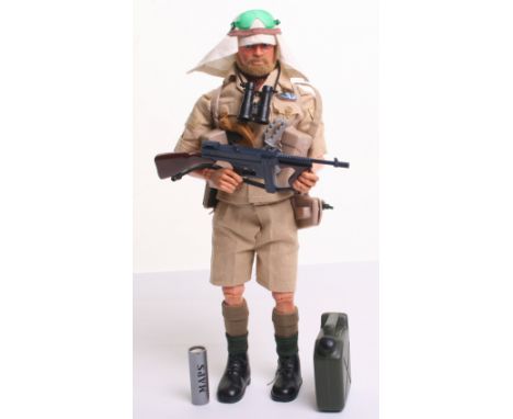
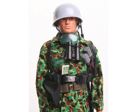
Lot 266

Scarce Palitoy vintage Action Man Long Range Desert Group on blond flocked hair/bearded, gripping hands, eagle eyed doll, shirt, trousers, socks, Arab headdress, bandana, anklets, webbing, commando knife, water bottle, Thompson machine gun, grenades, entrenching tool, plus map and case, gloves, knuckle knife, binoculars and pistol , in near mint original condition
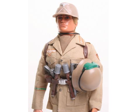
Lot 268

Palitoy vintage Action Man German Afrika Corps, International card issue on blond flocked hair, gripping hands, eagle eyed doll, tunic, trousers, cap and boots, plus, helmet, equipment webbing, water bottle, stick grenades, bayonet, scabbard, KAR 98 rifle, luger pistol, goggles, map, knuckle knife, scarf and binoculars, in mint off the card original condition

Lot 272

Palitoy vintage Action Man German Luftwaffe Paratrooper, on blond flocked hair, gripping hands, eagle eyed doll, helmet, tunic, trousers and boots, plus equipment webbing, water bottle, stick grenades, bayonet, scabbard, KAR 98 rifle, luger pistol, webbing belt, goggles, map, scarf and binoculars, in mint off the International card original condition
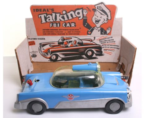
Lot 358

Scarce Ideal’s (USA) Talking FBI Car, circa 1950’s no 3072 Ideal Toy Corporation blue/silver plastic car “Mobile crime laboratory with everything you need to play special agent” removable plastic dome, flashlight, dashboard with removable phone, two pistols, camera with flash gun, Tommy gun, riot gun, swivel chair, swivel table with map, binoculars, two extra rifles, in excellent condition, approx length 14 ½” (37cms) complete with original card display box in excellent condition

Lot 196

A WWII escape map of Eastern Europe printed on silk

Lot 399

A VICTORIAN SATINWOOD POLE SCREEN, WITH SHIELD SHAPED NEEDLEWORK AND PAINTED BANNER OF A MOTHER AND CHILD WITH A DOG AND A MAHOGANY POLE SCREEN, THE OVAL FRAME CONTAINING A GEORGE III SILK EMBROIDERED MAP SAMPLER OF ENGLAND AND WALES, FAULTS

Lot 1009

A framed Botswana map, framed stamps and a partially filled cigar band album

Lot 1039

A framed map of Wiltshire from a plate by Jan Jansson (d.1664) issued by Peter Scheuk and Gerard Valk c1702

Lot 1040

A framed map of Wiltshire, William Kip from Cowden's Britainnia c1607 to verso

Lot 1041

A framed road map Marlborough to Wells and Chippenham to Wells to verso

Lot 1042

A framed map of Wiltshire by Robert Morden

Lot 1079

Seatons map of Palestine and Egypt, linen backed

Lot 867

'Map of the War' drawn under the direction of Hilaire Belloc for 'Land and Water', Map of First World War theatre mounted on linen, bound in cloth and complete with introduction

Lot 905

"Monumenta Historica Britanica" or "Materials for the History of Britain" Vol 1 by Petrie and Sharp 1848 with 27 plates, folding map, leather spine

Lot 993

A framed map of Oxfordshire and five various coloured prints of Bristol street scenes, Kings College, Whitehall and Kensington palace

Lot 320

After Dendy-Sadler. An Edwardian print depicting map reading in the study, signed in pencil by Sadler and another.

Lot 321

A late 17thC hand coloured map of Norfolk by Robert Morden, 58cm x 38cm.

Lot 322

A 20thC reproduction of the 1742 map of Boston, detailing The Stump and Market Cross, 59cm x 47cm.

Lot 349

Baedeker (Karl). Handbook for Travellers, Central Italy (1893), Northern Italy (1899), Belgium and Holland (1885), Rhine (1886), an Antiquarian Travellers map of Spain and Portugal, and Harriet Martineau's Complete Guide to the English Lakes, red cloth binding, spine in poor condition, (6). Provenance: Ex Duddington Manor

Lot 363

A wooden chest map decoration.

Lot 177

Two vintage measuring flasks or pipettes, and old coloured map of Berkshire and Windsor, 1350, and a Uganda railway publicity poster (4)

Lot 544

Mohamed Kako, Mugotio, Kenya carved stone egg and plate with world map and Different Colours one People etched

Lot 806

The Countye Palatine of Chester map and 1950s mirror

Lot 818

Framed and glazed map of Lancashire

Lot 169

A miscellaneous collection of shield plaques, to include: rugby world cup, Jeddah Golf Society Saudi Arabia, Singapore Rugby Union; together with framed cigarette cards; pewter; Bartholomew's Map; etc, in two boxes.

Lot 183

Nine Waddington's Jig-Map, and other toys; together with a retro drawing map.

Lot 226

Fraser (James B.) An Historical and Descriptive Account of Persia, 12mo, cloth, folding map, additional engraved title-page, plates, Edinburgh, 1834.

Lot 229

Russell (Rev. M.) Polynesia... an Historical Account of the Principal Islands in the South Sea, including New Zealand, map, advertisements at the end, Edinburgh, 1842; Murray (H.) The United States of America, 3 vols, plate, illustrations, Edinburgh, 1844; Murray (H.) The Travels of Marco Polo, 2 maps, advertisements at the beginning, Edinburgh, 1844, together 5 vols, 12mo, uniform cloth, additional title-page with engraved vignette in each vol. (5)

Lot 564

An antique map of Northumberland with hand colouring, by John Speede; together with two engravings. (3)

Lot 581

A reproduction map of County Durham; together with two prints depicting circus acts (3)

Lot 604

Coloured engravings - "The George Stephenson Centenary"- published for Newcastle Illustrated; churches of Durham; "Newcastle Castle"; and a map of Staffordshire. (4)

Lot 609

Antique engraved maps with hand colouring - "Newcastle Upon Tyne", by Greenvile Collins; and a map of County Durham, by Johannes Blaeu. (2)

Lot 610

An antique engraved map with hand colouring - "Britannicae, Insurae"; an etching of a French street scene with Cathedral; limited edition print of Northumberland numbered 466/502; and a reproduction map of Chester. (4)

Lot 269

A printed map of Henley, together with a Moet & Chandon champagne print, and two others. (4)

Lot 589

A Framed Print 'Castles of Ireland', along with a framed map, (2).

Lot 954

A Tinted Map, Les Isles Britanniques

Lot 501

A Daily Telegraph War Map No.4, showing the advances and the scenes of battle for the British is WWI and WWII, together with a small silver half hunter fob watch in leather strap and a Canadian 28 North West Battalion badge (3)

Lot 548

A small collection of WWII and later aviation items, including an RAF wallet, a silk printed map of the Pyrenees, a Daily Mail War Atlas, a pair military issue air crew anti-glare spectacles, three press photographs and a Bulldog IIA Aeroplane manual (8)

Lot 565

Two British Pattern 1888 Mk1 knife bayonets, one marked SA 3 INF 254 to terminal and the other SA 1 INF 119, both with scabbards, together with two military silk maps, one of Siam, plus a Daily Telegraph War Map of the New British Front (no.13)

Loading...Loading...
  • 109182 item(s)
    /page

Recently Viewed Lots