We found 109182 price guide item(s) matching your search
There are 109182 lots that match your search criteria. Subscribe now to get instant access to the full price guide service.
Click here to subscribe- List
- Grid
-
109182 item(s)/page


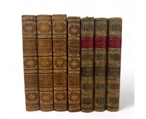
Lot 434
A collection of travelogues. HALL (Basil) - Hall's Travels in North America in the years 1827 and 1828 (3 volumes), first edition, Cadell and Co,1829. Leather bound with marble boards, raised bands and gilt tooling to spine. Vol 1 folding map. Vol 3 folding chart. Some foxing to front pages. Books would benefit from a professional clean. HALL (Basil), Halls's Journal, a journal on the coasts of Chili, Peru, and Mexico in the years 1820, 1821, 1822. Volume 1. 3rd Edition, published by Archibald Constable and Co, 1824. Includes map of South America. Leather bound with marble boards, raised bands and gilt tooling to spine. Books would benefit from a professional clean. EUSTACE, (Rev. John Chetwode), Eustace's Tour Through Italy, Volumes I to III. 8th edition. Volume 1 with folding map Very light spotting on internal pages.


Lot 95
A Modern framed limited edition "The Silver Map of Great Britain", also etched with the Boundary lines and the Coats of Arms of the Historic Counties, limited edition no. 1872/3000, hallmarked by Danbury Mint, London, 1978, approx. 36.2cm x 54.8cm, framed and glazed. Further details: in good condition, general wear.


![[Wood, Anthony]. Historia et Antiquitates Universitatis Oxoniensis, 1st edition, Oxford: Sheldonian Theatre, 1674, additional](https://cdn.globalauctionplatform.com/dd84a124-1580-49ca-a704-b13201270f77/74ef7a4f-aa42-49da-a518-b16200a8a5da/468x382.jpg)
Lot 68
[Wood, Anthony]. Historia et Antiquitates Universitatis Oxoniensis, 1st edition, Oxford: Sheldonian Theatre, 1674, additional engraved title, title with vignette of the Sheldonian Theatre, folding engraved plan (with closed tears at foot), water stains and small marginal tears throughout, Cornwell House ink stamp to front free endpaper, contemporary calf, rubbed with some stains and edge wear, folio, together with:Hutchins (John). The History and Antiquities of the county of Dorset..., 2 volumes, 1st edition, London, W. Bower and J. Nichols. 1774, folding frontispiece map of Dorset by J. Bayly, 1773 plus 38 engraved maps, views, plans, pedigrees and others (some folding), previous ownership inscription to top of title page and bookplate of D Okeden to front pastedown to each volume, some manuscript annotations to a few margins, additions and corrections bound to rear, contemporary calf rebacked preserving boards, contrasting title labels to spine, scuffed and rubbed with small areas of loss, corners bumped, folio, plusThoresby (Ralph). Ducatus Leodiensis: or, the Topography of the Ancient and Populus Town and Parish of Leeds and Parts Adjacent in the West-Riding of the County of York..., 1st edition, London: Printed for Maurice Atkins, 1715, engraved portrait frontispiece,12 engraved maps, plates and views (some folding, some spotted and many with reinforced folds), contemporary manuscript annotation to foot of title page, juvenile scribing to page 426, lacking B2, contemporary blind embossed calf, hinges and joints cracked and worn, rubbed and worn, corners bumped, small folio and other British topography by or after S. C. Hall, John Gorton, Dugdale, Throsbys, John Ogilby, John Mackay Wilson, Illustrated London News and others, various sizes and condition QTY: (43 )NOTE:Sold as a collection of prints not subject to return.

Lot 6
Brockendon (William). Illustrations of the Passes of the Alps, by which Italy communicates with France, Switzerland, and Germany, 2 volumes, London: Printed for the author, 1838, 108 engraved plates and maps throughout (including vignette titles), double-page map at rear of volume 2, near-contemporary ownership inscription of Owen Roberts to front blank of volume 1, all edges gilt, modern black quarter morocco gilt by the Old Court Bindery, spines faded, 4to, together with:Journals of Excursions in the Alps: The Pennine, Graian, Cottian Rhethian, Lepontian, and Bernese, 3rd edition, London: John Duncan, 1845, folding map (crude tape repairs to verso), hinges tender, original red blindstamped cloth gilt, rebacked with original spine relaid, rubbed, 8voQTY: (3)

Lot 136
Folding maps. A collection of 10 folding maps of towns/boundaries in England, mostly 19th century, including Mogg (William publisher). Map of the Environs of London, circa 1856 -1862, engraved folding map dissected and laid on linen with contemporary outline colouring, cartographer name masked from title with contemporary paper, contemporary publishers slip pasted to lower margin, a little frayed at edges, 810 x 1080 mm, together with:Stephens & Mackintosh (publisher). New Business Map of the Parliamentary Division of Newcastle upon Tyne, Leicester: printed by Geo. Gibbons & Co.,1903, folding lithographic map printed in red black and blue, original printed paper wrappers to verso, a little dust soiled, a few chips and tears to margins, 850 x 740 mm, limited to 1,017 copies, plusStephens & Mackintosh (publisher). Business Map of the Sowerby Parliamentary Division of Yorkshire, Leicester: printed by Geo. Gibbons & Co., 1902, folding lithographic map printed in red, black and green, mounted on linen, a little toned and some folds strengthened to verso, folded into original red gilt cloth covers, boards a little rubbed and worn, 585 x 900 mm, limited to 1,226 copies, and 7 others including Sanderson's Nottinghamshire and District Railway, London: Job, Bros. & Co.,1861, William Sanders Map of the Bristol Coal Fields (sheet 19), circa. 1862, Save The Gogs published by the Cambridge Preservation Society, 1937, Map of Epping Forest, Reduced by Permission from the Authenticated Arbitration Map, 1882, London: Edward Stanford, Barnetts' Offical Street Plan, Wandsworth and others, various sizes and condition QTY: (10)
![* Hampshire. Speed (John), Hantshire described and devided, Thomas Bassett & Richard Chiswell [1676], uncoloured engraved](https://cdn.globalauctionplatform.com/dd84a124-1580-49ca-a704-b13201270f77/06f5ba05-fe7c-402e-a585-b16200a8c703/468x382.jpg)
Lot 141
* Hampshire. Speed (John), Hantshire described and devided, Thomas Bassett & Richard Chiswell [1676], uncoloured engraved map, inset town plan of Winchester, central fold strengthened and repaired on the verso causing slight staining to the recto, good margins, 380 x 510 mm, English text on verso, framed and double-glazed, together with another 22 maps, 17th - 19th century, engraved British and foreign maps, including examples by or after Saxton/Hole, Van den Keere, Bertius, Cary, Morden, Bonne, Blome, Osborne, Mercator/Hondius, Moule, Blaeu and Kitchin, various sizes, good condition, all framed and glazedQTY: (23)
Lot 117
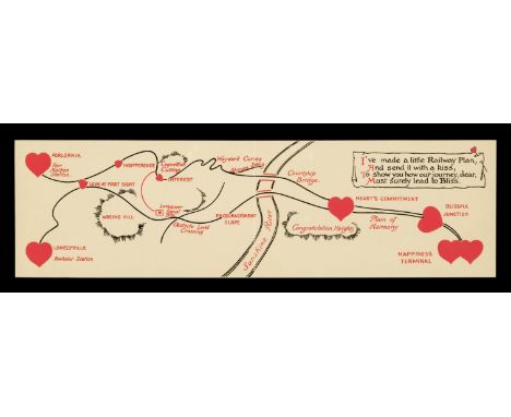
Cartographic Ephemera. Maps, Valentines and Postcards, late 19th and early 20th-century, a collection relating to love, marriage and courtship, including; Land of Matrimony. circa 1850, pen and watercolour allegorical map by an unknown artist, laid on later card, 105 x 325 mm together with; Beeching (G. S.). Map of Matrimony, circa 1880, colour lithograph allegorical map on card, trimmed close to printed edge, 80 x 120 mm, Nister-Dutton. Cupid's Railway Map, circa 1920, chromolighograph folding valentine card, size when open 70 x 250 mm (with reproduction of the same), Photochrom Co Ltd. Map of Marriageland, circa 1905, chromolighograph postcard, used, a few small areas of loss, 90 x 140 mm, Mappa do Coração. an unattributed colour lithograph showing an allegorical island of love in the shape of a heart in Portuguese, 140 x 90 mm, Knight Bros. (publishers). Chart of Betrothal Bay shewing the Male Route to Churchdoor, tinted lithographic postcard in the form of an allegorical map of the route to marriage, used, light spotting to verso, 90 x 140 mm, Knight Bros. (publishers). Truelove River. colour lithograph postcard showing an allegorical map and poem, 140 x 90 mm, Valentine's card. circa 1903, chromolighograph card with a manuscript map of lovers' route to bliss, light spotting, overall size 100 x 100 mm and 3 others related, various sizes and condition QTY: (12)

Lot 146
* Istanbul. Braun (Georg & Hogenberg Franz), Byzantium Nunc Constantinopolis, Cologne, circa 1580, engraved map with contemporary hand-colouring, twelve portrait medallions to the lower margin, slight text show through, 330 x 480 mm, mounted, framed and glazedQTY: (1)NOTE:The second state with the last roundel now completed with a portrait of Sultan Murad III. The Bosphorus and the Golden Horn are shown crowded with both Turkish galleys and European galleons. In the centre, a mounted Turkish Sultan is supported by his Janissaries armed with bows and swords.
![* China. Mercator (Gerard), China, [1606 or later], hand-coloured engraved map, 345 x 465 mm, mounted, framed and glazedQTY:](https://cdn.globalauctionplatform.com/dd84a124-1580-49ca-a704-b13201270f77/b4719eb4-4639-442d-9842-b16200a8bd29/468x382.jpg)
Lot 120
* China. Mercator (Gerard), China, [1606 or later], hand-coloured engraved map, 345 x 465 mm, mounted, framed and glazedQTY: (1)NOTE:A decorative and early map of China. The Great Wall is shown in the northwest of China and to the left is a vignette illustration of a Chinese land yacht. The Bering Strait is annotated as the Strait of Anian, with a small section of the northwest American coast in the upper right corner. Two ships, one a Chinese junk and the other European, patrol the Pacific Ocean. In an additional cartouche, there is a description and illustration of a Japanese crucifixion.

Lot 159
London. Cruchley (George Frederick), Cruchley's New Plan of London Shewing all the New and Intended Improvements to the Present Time, 1834, engraved map with contemporary outline colouring, sectionalised and laid on linen, 420 x 825 mm, marbled endpapers with small engraved book seller's label, contained in a contemporary marbled card slipcase with publisher's printed yellow label to the upper cover, slipcase wornQTY: (1)NOTE:James Howgego. Printed Maps of London. Number 307, state 7.

Lot 158
London. Gill (MacDonald). Wonderground Map of London Town, The Westminster Press, circa 1924, photolithographic colour printed map, long closed tears and splits along old folds, pinholes to corners, repairs and strengthened on verso, 745 x 930 mmQTY: (1)NOTE:The Wonderground map was commissioned by The London Underground and designed to be displayed in tube stations. Its intense pictorial content caught the public’s imagination and as a result Gill is often credited with creating a resurgence in the genre of decorative map making. This is the 1924 edition (slightly smaller than Gill's original 1913 version) and is assumed to have been altered to help the promotion of the British Empire Exhibition which was held at Wembley between April and October of that year. It can be identified by a sign saying:- 'On To Wembley' and an empire lion in the top left-hand corner below the man pushing a bus.Information courtesy of Roderick Barron, Bryars & Bryars and Claire Dobbin.

Lot 39
Ross (John). Narrative of a Second Voyage in search of a North-West Passage and of a Residence in the Arctic Regions during the Years 1829, 1830, 1831, 1832, 1833, 1st edition, London: A. W. Webster, 1835, 24 plates (including some hand-coloured), 6 maps (2 folding), armorial bookplate of Hans Sloane Stanley to front pastedown, hinges neatly repaired, folding map fold reinforced with tape to verso, original blue cloth, rebacked retaining original spine label, rubbed, 4to, together with:Appendix to the Narrative of a Second Voyage in search of a North-West Passage and of a residence in the Arctic Regions, during the years 1829, 1830, 1831, 1832, 1833, 1st edition, London: A. W. Webster, 1835, 19 lithograph plates (of 20, some coloured or tinted), spotted, original blue cloth, lacking spine with boards and gatherings loose, some wear, 4toQTY: (2)NOTE:Abbey Travel 636.
![* China. Ortelius (Abraham), Chinae olim Sinarum regionis nova descriptio, auctore Ludovico Georgio, Antwerp [1592 or later],](https://cdn.globalauctionplatform.com/dd84a124-1580-49ca-a704-b13201270f77/ac2c29d0-b8fc-416b-9102-b16200a8bda7/468x382.jpg)
Lot 121
* China. Ortelius (Abraham), Chinae olim Sinarum regionis nova descriptio, auctore Ludovico Georgio, Antwerp [1592 or later], hand-coloured engraved map, orientated to the west, large strapwork cartouche and mileage scale, good margins, 370 x 470 mm, mounted, framed and double-glazed, Latin text on versoQTY: (1)NOTE:Marcel van den Broecke. Ortelius Atlas Maps, number 164. A fine copy of the first European map of China being the second state with “Les Philippinas” inserted above “Sinus Magnus”.
![* Cairo. Braun (Georg & Hogenberg Frans), Cairus, quae olim Babylon; Aegypti Maxima Urbs [1572 - 1618], engraved map with](https://cdn.globalauctionplatform.com/dd84a124-1580-49ca-a704-b13201270f77/d7c8779c-15c0-4fcf-a267-b16200a8bb2e/468x382.jpg)
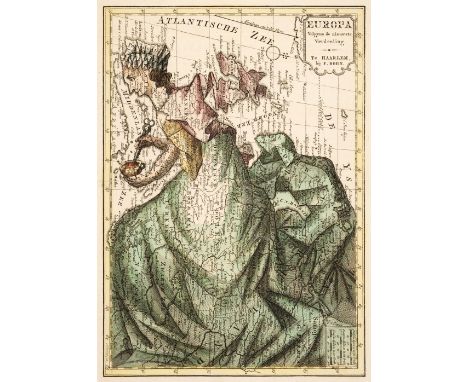
Lot 134
Europe. Bohn (F.), Europa Volgens de Nieuwste Verdeeling, Haarlem, circa 1794, engraved allegorical map with contemporary wash colouring, old folds, 250 x 175 mmQTY: (1)NOTE:Mercator's World, IV, 1 (The Female Landscape). An allegorical map which instead of showing Europe as a regal queen, reduces her to a homely middle-aged housewife. The female figure is superimposed over a map that includes a surprising amount of detail. Spain & Portugal comprise her head, Italy is her left arm, whilst her right arm stirs a pot containing Corsica and Sardinia. Her scarf forms the British Isles, and the rest of the continent is consumed under the folds of her voluminous dress. Originally published in Geheimzinnige Toebereidselen tot eene Boertige Reis Door Europa, Part I.

Lot 187
World. Bullock (L. G.), United Nations Map of the World, John Bartholomew & Son Ltd. Edinburgh, circa 1946, colour-printed pictorial map, old folds, short split along one fold, 670 x 920 mmQTY: (1)NOTE:Leslie George Bullock was a civil servant who produced several pictorial maps for children. The map of the United Nations bears a close similarity to MacDonald Gill's map 'Time and Time Map of the Atlantic Charter'. Tim Bryars describes the map as "A wonderful example of postwar optimism" which seems perfectly apposite. The royalties from his map of London were made over almost entirely to the benefit of Great Ormond Street Hospital for Sick Children.Further information on these maps and Leslie Bullock can be found at Bryars&Bryars.co.uk and BarronMaps.com
Lot 4
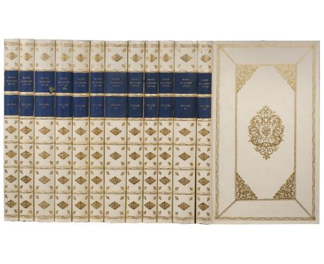
Blaeu (Johannes). The Third Centenary Edition of Johan Blaeu Le Grand Atlas ou Cosmographie Blaviane, Amsterdam 1663, 12 volumes, Facsimile Edition, Amsterdam: Theatrum Orbis Terrarum Ltd., 1967-68, titles and preliminaries, hemispheral map of the world, printed in colour and 598 uncoloured maps and plates, text in French (a reprint of the first French edition of 1663), library stamps to edges of text block at head and foot, publisher's decorative gilt leatherette (faux vellum), with contrasting blue gilt labels to the spines (one label frayed), slightly bumped, some dust soiling, folioQTY: (12)NOTE:Limited edition 212/1000.

Lot 35
Palestine and the Middle-East. Palestine Partition Commission Report, London: His Majesty's Stationery Office, 1938, 12 folding maps at rear (of 13), original blue printed paper wrappers, rebacked in laterpaper, 8vo, together with:Report of the Anglo-American Committee of Enquiry regarding the problems of European Jewry and Palestine, Lausanne: His Majesty's Stationery Office, 1946, 80 pp., original blue printed paper wrappers, 8vo, withCorrespondence Between Sir Henry McMahon... and the Sherif Hussein of Mecca, London: His Majesty's Stationery Office, 1939, 18 pp., folding map at rear, original paper printed paper wrappers, 8vo, plusReport of a Committee set up to consider certain correspondence between Sir Henry Mahon and the Sharif of Mecca in 1915 and 1916, London: His Majesty's Stationery Office, 1939, 51 pp., original printed paper wrappers, 8vo, with Proposals for the Future of Palestine (1947), Palestine, Statement with regard to British Policy (1930), Palestine Land Transfer Regulations (1940), Palestine Royal Commission Report (reprinted 1946) and 7 others relatedQTY: (11)
Lot 53
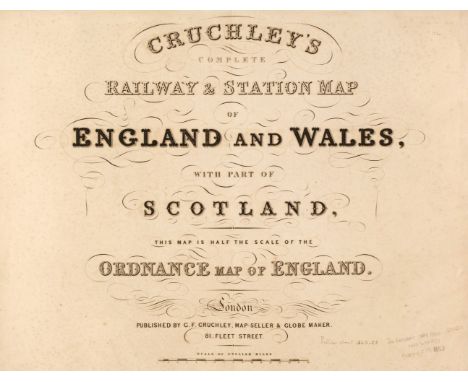
Cruchley (G. K. publisher). Cruchley's Complete Railway & Station Map of England and Wales, with Part of Scotland, This Map is Half the Scale of the Ordnance Map of England, circa 1860, double-page calligraphic title, index map and 65 (complete as index map) engraved double-page maps, all with contemporary wash colouring, index maps and sheets 1, 2, 3, 10 and 19 with repaired closed tears, some affecting the printed image, additional unattributed railway map of Scotland tipped in before the title page, later endpapers, later half cloth over contemporary boards with contemporary morocco gilt title label to the upper siding, worn and stained, folioQTY: (1)
Lot 311
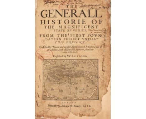
Fougasses (Thomas de). The Generall Historie of the Magnificent State of Venice. From the first foundation thereof untill this present, translated by W. Shute, 2 parts in one, 1st English edition, London: printed by G. Eld and W. Stansby, 1612, title with woodcut map of Venice (title with red ink stamp and laid down with tears and marginal losses), woodcut portraits of Venetian Doges, lacking leaf B2 (i.e pp. 3-4), occasional toning and light spotting, a few leaves frayed at outer margins, early ownership signatures of Edward Emerson, John Touch and Mariona & Anna Mack front and rear, modern calf-backed marbled boards, folio QTY: (1)NOTE:ESTC S121332; STC 11207. Sold with all faults not subject to return.
Lot 198
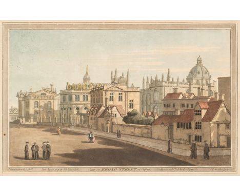
* British Topography. A collection of approximately 80 views, 18th & 19th century, including Illustrated London News (publisher). London in 1842. Taken from the Summit of the Duke of York's Column, 1843, two uncoloured engraved panoramas on one sheet (as published), old folds, small holes where old folds cross, slight spotting, dust soiling and creasing, 830 x 1185 mm, together with Stadler (J. C.). View in Broad Street in Oxford, J. & J. Boydell, June 1st 1793, aquatint after J. Farington, contemporary hand-colouring, with Tombleson (W.). Sixteen Views from the River Thames, circa 1840, uncoloured engraved views with decorative borders, some dust soiling and staining, each approximately 175 x 225 mm, plus Beeverell (James). A collection of approximately 50 engraved views, [Leiden: Pierre Vander Aa, 1727], uncoloured engraved views and prospects (including the map of London) a few plates with fraying to one margin, each approximately 135 x 155 mm, with others similarQTY: (approx.80)

Lot 153
Liozu (Jacques). Eight Pictorial Maps, Untitled Map of the World (on Mercator's projection), Europe Occidentale, Amérique du Sud, Amérique du Nord et Centrale, Asie, Australie & Océanie, Afrique [and] Europe Central & Orientale, copyright by Odé, Paris, 1951, colour printed photolithographic decorative pictorial maps, slight spotting to Europe Centrale..., and Afrique, each approximately 350 x 510 mm, contained in a contemporary publisher's card boxQTY: (8)
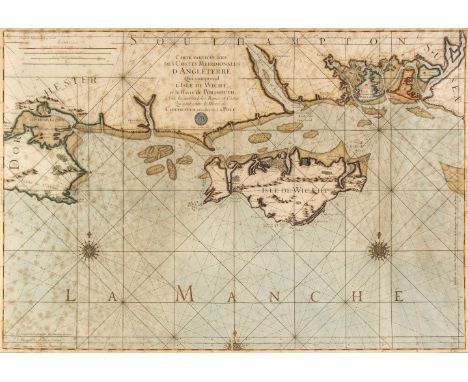
Lot 182
* The Solent. Carte Particuliere des Costes Meridionales d'Angleterre qui comprend l'Isle de Wicht, et le Havre de Portsmouth, avec les autres Isles, Bancs et Costes qui sont entre le Havre de Chichester, et celuy de la Pole, published by Dépôt Des Cartes Et Plans De La Marine. circa 1750, engraved map of the Isle of Wight and southern coasts of England between Poole and Thorney Island, crest of Dépôt de la Marine below the title, contemporary hand-colouring, numerous rhumb lines, 3 compass roses, distance scales in French, English and Spanish leagues, faint foxing, small printers crease to compass rose at lower margin, 630 x 880 mm mount aperture, framed and glazed (720 x 980 mm) QTY: (1)NOTE:From the third edition of Neptune François, published in 1753 by Dépôt de la Marine.Dépôt Des Cartes Et Plans De La Marine is a French hydrographic mapping organisation founded in 1720. Important cartographers of the day were associated with the organisation in their attempts to improve existing cartographic material including Philippe Buache, Giovanni Rizzi-Zannoni, Rigobert Bonne, Jean Nicolas Buache and Jacques-Nicholas Bellin who published this particular map.

Lot 5
Boissard (Jean-Jacques, Theodor De Bry). Romanae Urbis topographiae et antiquitatum, 6 parts in 3 volumes, Frankfurt: Thedor De Bry, 1597-1602, 5 engraved titles (lacking the title to the first part), 8 engraved portraits of Boissard & De Bry, 522 engraved plates (plus duplicates), 1 double-page map, lacking 3 folding maps, worming (especially heavy to 6th part), occasional dust-soiling, all edges gilt, early 19th-century continental brown full morocco gilt, gilt central panels to covers incorporating gilt monogram, panels with gilt corner motifs of a tree and a rampant lion, some wear, spines faded, old paper labels to foot of spines, 4toQTY: (3)NOTE:Adams B-2331-32-36-38-39-41; Brunet I, 1069.
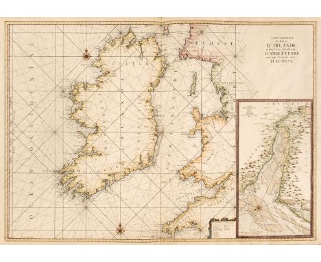
Lot 145
Ireland. Van Loon (Hermanus.), Carte Generale des Costes D'Irlande et des Costes Occidentales D'Angleterre avec une Partie de celles D'Ecosse, [1661 or later], large hand-coloured sea chart of Ireland and the west coast of England & Wales, inset map of the River Dee and Chester, compass rose and numerous rhumb lines, good margins, 610 x 860 mm, together with Seale (R. W.). A Correct of St George's Channel and the Irish Sea..., published for Mr Tindal's Continuation of Mr Rapin's History, circa 1750, hand-coloured sea chart of Ireland and the west coast of England & Wales, old folds, 485 x 380 mmQTY: (2)
Lot 127
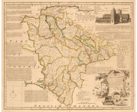
Devon. Bowen (Emanuel), An Accurate Map of Devon Shire, Divided into its Hundreds, Drawn from the best Authorities..., John Bowles & Sons, Messrs Bakewell & Parker, T. Bowles, H. Overton, T. Kitchin, R. Sayer and J. Ryall, 1762, engraved map with contemporary outline colouring, originally published in 'The Royal English Atlas', large uncoloured allegorical cartouche and vignette of Exeter Cathedral Church, slight overall toning, 415 x 500 mm, together with Greenwood (C. & J.). Map of the County of Devon, from an Actual Survey made in the years 1825 & 1826..., Greenwood & Co. July 4th 1829, engraved map with contemporary wash colouring, inset map of Lundy Island, large calligraphic cartouche, uncoloured vignette of Exeter Cathedral, reference to the hundreds and a compass rose, very slight spotting, 620 x 710 mm, with Cary (John). A New Map of Devonshire Divided into Hundreds Exhibiting its Roads, Rivers, Parks &c. 1807, engraved map with wash outline colouring, oval cartouche, very slight staining, slight creasing along the central fold, old ink library stamp to the lower margin not affecting printed image, 500 x 550 mm, plus Stockdale (John). A Map of Devonshire from the best Authorities, 1805, engraved map with contemporary outline colouring and some later enhancement, old folds, some offsetting, 435 x 485 mm, and Weller (Edward). Devonshire (North Division) & Devonshire (South Division), circa 1860, two lithographic maps with contemporary outline colouring, each sheet approximately 315 x 440 mm, supplied with two sheets of descriptive text, with Fisher Son & Co. (publishers). Devonshire [1832 - 45], engraved map with contemporary outline colouring, some dust soiling and offsetting, 365 x 515 mmQTY: (7)
Lot 29
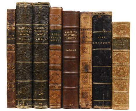
Lyon (George Francis). A Brief Narrative of an Unsuccessful Attempt to reach Repulse Bay, through Sir Thomas Rowe's "Welcome" in his Majesty's Ship Griper, 1st edition, London: John Murray, 1825, folding map, 7 engraved plates, ink ownership inscription of Irene Bevan to front free endpaper verso, spotted, library bookplate of Newtown Church library to front pastedown, contemporary calf gilt, rebacked with original spine relaid, lightly rubbed, 8vo, together with:The Private Journal of Captain G. F. Lyon, of H. M. S. Hecla, during the recent voyage of discovery under Captain Parry, 1st edition, London: John Murray, 1824, engraved frontispiece, 6 engraved plates, folding map, a few light spots, contemporary half calf gilt, rebacked with original spine relaid, lightly rubbed, 8vo, withNansen (Fridtjof). "Farthest North", bein the record of a voyage of exploration of the ship Fram 1893-96 and of fifteen months' sleigh journey, 2 volumes, 1st edition, London: George Newnes, 1898, frontispieces, black and white illustrations throughout, near-contemporary black straight-grain morocco gilt, rubbed, some faint staining to boards, with 4 other leatherbound polar works, including J. A. MacGahan's Under the Northern Lights (1876) & the popular edition of Charles Hall's Life with the Esquimaux (1865)QTY: (8)
Lot 264
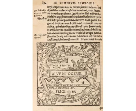
Macrobius (Ambrosius Aurelius Theodosius). In somnium Scipionis, Lib. II. Saturnaliorum, Lib. VII. Lyon: apud Seb. Gryphium, 1550, 8vo, title with printer's woodcut device, woodcut world map to verso of i8 (p.154, map dimensions 8 x 8 cm) and several diagrams to text, worm trail at foot of leaves a1-a6 and P1-R8, occasional early underscoring and marginal annotations, some light damp-staining and few marks, 19th-century bookplate of John Theodore Foxell to upper pastedown, contemporary calf with decorative device in gilt to centre of each board, paper title label at head of spine, upper joint neatly repaired, 8vo (16.6 x 10.5 cm)QTY: (1)NOTE:Shirley 13. Not in Adams.The works of Macrobius, a fifth-century AD Roman philosopher, were of great popularity throughout the Middle Ages. His neoplatonic commentary on Cicero includes, among many references to the pseudo-sciences, a geographic concept which is different from that of Ptolemy. The inhabited world north of the Equator is balanced by a southern continent and divided from it by water... A number of different blocks and variants of Macrobius' maps have been recorded. (Shirley).
Lot 20
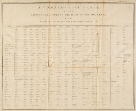
Forster (John Reinold). Observations Made During a Voyage Round the World, on the Physical Geography, Natural History, and Ethic Philosophy, 1st edition, London: G. Robinson, 1778, large folding table of the 'various languages in the isles of the south-sea', lacking folding map, errata, list of subscribers and final text leaf, contemporary small ownership stamp 'W. Tharp' to title with corresponding brown ink ownership inscription to head of front free endpaper, preliminary leaves slightly frayed with occasional small loss, a few light spots, early 19th-century half calf gilt, some light wear to spine and extremities, 4toQTY: (1)NOTE:Hill 628; Rosove 140.A1 (“Very scarce”); Sabin 25140; Spence 467.

Lot 354
Rowe (Nicholas). Lucan's Pharsalia. Translated into English Verse by Nicholas Rowe, Esq; Servant to His Majesty, 1st edition, Large Paper copy, London: Jacob Tonson, 1718, engraved frontispiece by B. Haron after Louis Cheron, title with engraved vignette, dedication leaf to the King, preface by James Welwood, folding engraved map of the Roman Empire, engraved initials and illustrations, list of subscribers, textblock 45 x 27 cm, endpapers renewed, contemporary full calf, rubbed and scuffed, modern reback retaining original red morocco spine label, tall folio (binding 45.5 x 28.5 cm)QTY: (1)NOTE:ESTC T114104; Foxon R293. Large Paper issue of Rowe's translation of the Roman poet Lucan.
![Tennant (Lilian, Illustrator). Stories of Old by E[lizabeth] L[ouisa] Hoskyn, containing twelve full-page illustrations in co](https://cdn.globalauctionplatform.com/dd84a124-1580-49ca-a704-b13201270f77/8292a479-ea2a-4e13-9392-b16200a8d9bf/468x382.jpg)
Lot 181
Tennant (Lilian, Illustrator). Stories of Old by E[lizabeth] L[ouisa] Hoskyn, containing twelve full-page illustrations in colour by L.Tennant, London: Adam and Charles Black, 1912, 12 (complete as list), colour-printed allegorical maps by Lillian Tennant, each showing a historical or mythological character set within a map of the country of the story's origin, 1 map disbound and loose with a little fraying, some maps with a little staining to the margins, minor spotting to text, publisher's decorative cloth boards with colour printed panel to upper cover, juvenile scribbling to upper board, a little worn, spine chipped and frayed, small 4toQTY: (1)NOTE:Lilian Tennant (née Lancaster, 1852-1939) had her first allegorical map illustrations published when she was just 15 years old in Geographical Fun: Being Humourous Outlines of Various Countries (1868) accompanied with an introduction and descriptive lines by "Aleph", the alias of Mr William Harvey. After a long and successful career as an international pantomime actress and performer, Tennant only returned to illustration as a widow living in Brighton at the age of 45 where she drew and produced the maps for Stories of Old and other publications.Information courtesy of BarronMaps.com
Lot 423
Amedeo (Luigi, Duke of the Abruzzi). On the "Polar Star" in the Arctic Sea, translated by William Le Quex, 2 volumes, 1st English edition, 1903, five maps including two contained in the rear pocket of volume 2, 2 folding panoramas, photogravure plates, front gutters partially cracked, some minor spotting, top edge gilt, original gilt decorated green cloth, spine very lightly rubbed, large 8vo, together with:Whymper (Edward), Travels Amongst the Great Andes of the Equator, 1st edition, London: John Murray 1892, 118 monochrome illustrations plus 4 maps, period inscription to the head of the title page, some light toning, original gilt decorated cloth, spine faded & slightly rubbed to head & foot, 8vo, plus other 18th-20th century miscellaneous literature, including General View of the Agriculture in the county of Somerset;..., by John Billigsley, London: printed by W. Smith, 1794, colour folding map frontispiece, modern half morocco, 4to, General View of the Agriculture of the North Riding of Yorkshire,.., by Mr. Tuke, London: printed by W. Bulmer and Co., 1794, modern half morocco, 4to, General View of the Agriculture of the county of Kent,..., by John Boys, Brentford: printed by P. Norbury, 1794, modern half morocco, 4to, plus 3 other similar volumes, some leather binding, some original cloth in dust jackets, G/VG, 8vo/4toQTY: (3 shelves)

Lot 126
Devon. Bickham (G.), A Map of Devon - Shire West from London..., 1750, uncoloured 'birds-eye' map with text above and below the image, 260 x 160 mm, supplied with four pages of contemporary descriptive text, together with Ramble (Reuben). Devonshire, circa 1850, engraved map with decorative lithographic vignettes to the border, contemporary hand-colouring, supplied with a page of descriptive text, 205 x 160 mm, with Van den Keere (Pieter). Devonshire, circa 1627, hand-coloured engraved map, 85 x 120 mm, English text on verso, with three pages of descriptive text, plus Bowen (Emanuel). Devon Shire Divided into Hundreds Containing the City, Burough and Market Towns &c...., circa 1777, engraved map with contemporary outline colouring, originally published in the 'Atlas Anglicanus', 235 x 340 mm, and Morden (Robert). Devonshire, circa 1720, uncoloured engraved map, old folds, 175 x 210 mm, with Pigot (James). Devonshire, circa 1829, engraved map with contemporary outline colouring, 245 x 365 mm, with another 14 county and regional maps of Devon and its surroundings, including examples by or after Cobbett, Laurie & Whittle, Cadell, Kitchin, Aiken and Seller/Grose, various sizes, good conditionQTY: (20)

Lot 184
Wauthier (John M.). Punchinellography of England by Mr Wauthier, Geog, London, published by Didier & Tebbett, 75 St James's St, Ented at Stationers Hall, 1st Jany 1808, etched physiological map of England and Wales with contemporary hand colouring, the map comprised of numerous fictitious and historical faces, references to the Punchinellography list to the left margin, old folds strengthened to verso, some areas of wear with repairs, the whole backed on archival tissue, a little toned, slight dust soiling, 565 x 470 mm QTY: (1)NOTE:Muir, English Children’s Books, 1600 to 1900. p 225; Whitehouse, Victorian Table Games p. 99.Rare. Only 3 institutional copies (British Library, Benedictine College, David Rumsey Collection).A Georgian board game which ‘endeavoured to give children an entertainment which while, like the merry little gentleman from whom its name is derived, it most powerfully arrests their attention by its whimsicality…,’ featuring unusual portraits of characters from history, literature and folklore to represent each county. The rules of the game can be studied from the pamphlet originally issued with the map via The David Rumsey Collection.Information courtesy of Bryars & Bryars. See more at Bryars & Bryars.co.uk

Lot 143
* Homann (Johann Baptiste). Planiglobii Terrestris Cum Utroq Hemisphaerio Caelesti Generalis Exhibitio..., Nuremberg, circa 1715, hand-coloured engraved hemispheral map of the world, two additional hemispheral celestial globes, insular California and an incomplete Australia & New Zealand, the margins decorated with symbolic representations which combine science and fantasy, including depictions of natural phenomena, the activity of volcanoes, tidal movements, waterspouts, precipitation and whirlpools, one printer's fold, very slight creasing, occasional repaired marginal closed tears, 490 x 575 mm, mounted, framed and glazedQTY: (1)NOTE:There is a slightly later state of this map with a corrected depiction of California as an island.
Lot 228
* Prints & Engravings. A collection of approximately 575 prints, mostly 19th-century, engravings, etchings and lithographs including British topographical views, natural history, advertisements, foreign topography, pencil drawings, genre, greetings cards, sporting and caricatures (Dr Syntax series), together with a partially excised scrap album containing greetings cards, scraps, drawings and photographs, with Saxton (Christopher & Hole G.). Glocestriae Comitatus olim sedes Dobunorum [1607 - 10], hand - coloured engraved map, large strapwork cartouche and mileage scale, slight creasing, 285 x 320 mmQTY: (approx. 575)
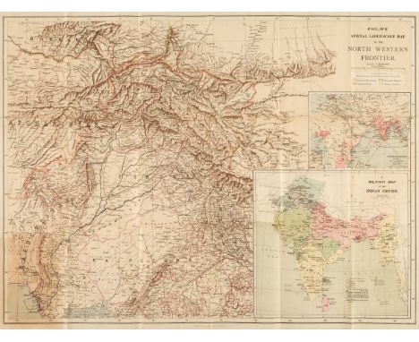
Lot 137
Folding maps. A collection of 6 folding maps of foreign parts, mostly 19th-century, including Philips's Special Large Scale Map of the North Western Frontier with a map of the Overland Routes and a Military Map of the Indian Empire, George Philip & Son, London & Liverpool, circa. 1897, folding colour lithographic map, lightly toned, laid on linen, folded in original printed cloth wrappers, 550 x 725 mm, together with:Stanford's Map of The Far East & Pacific Ocean to illustrate the international situation..., mandated territories are shown according to the latest information available, London: Edward Stanford, 1941, folding colour photolithographic map, pinholes to upper corners of margins, laid on linen, original wrappers to verso, 550 x 700 mm, plus Bartholomew's War Map of Afghanistan and the indo-Russian frontiers, with a large general map showing the connection between England, Russia, & India, Edinburgh: John Bartholomew, 1885, folding colour lithographic map, a few tears and holes to folds, original wrapper to verso, 830 x 615 mm, plusPhilip's Special Large Scale War Map of The Soudan, Extending to Suakim on the Red Sea, with an enlarged plan of Kharetu, London: George Philip & Son, 1885, folding colour lithographic map, printed in black and blue, some spotting, a few tears to folds, original wrapper to verso, 575 x 795 mm, plusMap of British Malaya including the Straits Settlements, Federated Malay States and Malay States not included in the Federation...., Published under the direction of the Surveyor General, 1924, folding colour lithographic map, light spotting, area of loss to top left corner, laid on linen, 915 x 880 mm, and Town of Accra, circa. 1930, folding colour lithographic map, a few pencil annotations to printed area, margins and manuscript title to verso, light toning, 900 x 450 mm QTY: (6)

Lot 178
South Africa. Boyle (Stuart), A Map of the Cape Peninsula Issued by The Cape Peninsula Publicity Association, Adderley Street Cape Town, South Africa, published by The Cape Times [1952], lithographic pictorial map, old folds, 545 x 330 mmQTY: (1)NOTE:A scarce pictorial map of the Cape of South Africa with only three institutional copies found. It may well have been published to celebrate the tricentenary of the Dutch settlement of the Cape. Stuart Boyle was primarily a book illustrator and provided work for several books including Evelyn Waugh's The Loved One. He also worked as a magazine and newspaper artist & political cartoonist and, in later life, for the advertising agency J Walter Thomson. He was the father of the illustrator, Catherine Brighton.
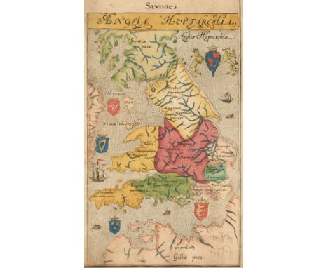
Lot 57
Lambard (William). A Perambulation of Kent: Conteining the description, Hystorie, and Customes of that Shyre. Collected and Written (for the most part) in the year 1570 by William Lambard of Lincolnes Inne Gent. and now increased by the addition of some things which the Authour him selfe hath observed since that time..., 1st edition, Imprinted at London [by Henry Middleton] for Ralphe Newberie, 1576, title within woodcut border with early signature Benj.(?) Taylor and marginal annotation dated Oct 4th 1692 (blank margin at head and foot of title cropped), hand-coloured engraved map 'Angliae Heptarchia' laid down to verso of final leaf of preliminaries ([par.]4) and border at head and fore-edge cropped, woodcut decorative initials, signature of Benj. Taylor at head of A1, occasional early annotations mostly to margins, last two leaves in duplicate with annotation to verso of final leaf, front pastedown bearing the signature John Francis Howell and armorial bookplate of Charles Spooner bearing the motto 'Imitari quem colis', contemporary calf with blind arabesque to centre of each board, neatly rebacked preserving original spine, lacking ties to boards, 4toQTY: (1)NOTE:STC 15175.The first edition of the first English county history, containing a list of the nobility and gentry from the Herald's Visitation in 1574, which was omitted from later editions. This work is considered to have formed a model of topographical writing which William Camden adopted.

Lot 107
Bonne (Rigobert). [Atlas Encyclopedique, Contenant la Geographie Ancienne, et quelques Cartes sur la Geographie du Moyen Age, la Geographie Moderne] Paris, circa 1788, lacking title pages and index, 130 (only of 140) uncoloured engraved double-page maps, some staining, slight offsetting and occasional toning throughout, the last map 'Terre de Kerguelen', creased, contemporary half vellum (reusing old documents) the whole covered in near contemporary paper, bumped, worn and frayed, spine partially detached, 4toQTY: (1)NOTE:Sold as a collection of maps, not subject to reurn.
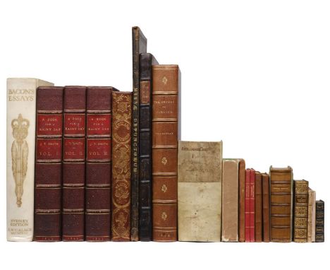
Lot 370
Smith (John Thomas). A Book for a Rainy Day: or Recollections of the Events of the last sixty-six years..., 3 volumes, London: Richard Bentley, 1845, extra-illustrated with engravings, etchings, mezzotints and lithographs including approximately 67 London views (3 folding), 138 portraits and 86 others including musical scores, British or foreign topographical views, satirical prints, theatre interest and others, most all 18th and 19th-century, a few with hand colouring, most window mounted but a few tipped in or laid on later paper, original text pages (8vo) window mounted, light spotting, damp staining, trimming or offsetting to a few leaves of text and prints, burgundy morocco gilt bookplate of W. A. Foyle, Beeleigh Abbey to front pastedown to each volume, hinges cracked, all edges gilt, 20th-century purple morocco, double morocco title labels to spine, upper panels inlaid with a closed umbrella design, joints rubbed, corners a little bumped, 4to, together with; Thackeray (William Makepeace). The Orphan of Pimlico and other Sketches, Fragments and Drawings...., with some notes by Anne-Isabella-Thackeray, 1st edition thus, London: Smith, Elder & Co, 1876, 3 engraved portrait frontispieces (2 black and white, 1 coloured duplicate), title in red and black, numerous plates with hand-coloured duplicates, original upper cover bound to front, burgundy morocco gilt bookplate of W. A. Foyle, Beeleigh Abbey, bookplate of Charles Plumptre Johnson and ink signature to front pastedown, gilt turn-ins, 20th-century deep purple gilt morocco by Zaensdorf, spine faded to brown, some scuff marks to boards, extremities slightly rubbed, folio, plus Helwig (Christoph). Theatrum Historicum et Chronologicum..., 5th edition, Francofurti: Christian Kleinius, 1666, title in red & black, bookplate of James Frampton to front pastedown, contemporary calf rebacked preserving spine, folio, plus Bacon (Francis). Bacon's Essays, Sydney Edition edited by Sydney Humphries, limited to 30 editions in vellum, London: A. & C. Black, 1912, engraved frontispiece, burgundy morocco gilt bookplate of W. A. Foyle, Beeleigh Abbey to front pastedown, ownership inscription of John Burns dated 1917 to front free endpaper, spotting to front and rear endpapers, untrimmed edges, printed letters from the publisher to the librarian from the publishers loosely inserted, original full vellum gilt, yapp fore-edges, minor soiling, 4to, plusBu?chner (Gottfried). Biblische Real- und Verbal- Hand-Concordanz Oder Exegetisch-Homiletisches Lexicon Darinne, 1st edition, Georg Adam Bonacker, Esslingen, 1747, slip printed 'Christian Freiderich Schall, 1747' pasted over publishes imprint on title page (partially lifting), contemporary vellum, rebacked preserving board and manuscript title section of original spine, 8vo, with a collection of others including; Beattie (William). Scotland illustrated in a Series of Views taken expressly for this Work by Messers. T. Allom, W. H. Bartlett..., 1838, numerous steel engraved plates plus folding map (some spotting), hinges cracked, all edges gilt, original red gilt morocco spine with relief buckram boards, a little worn, 4to, Little Books edited by Charles Whibley (2 volumes) London: Peter Davies, 1927, Forget me not; A Christmas and New Year’s Present for 1831, London: Published by R. Ackermann, 1831, many plates, original paper boards and slipcase, 6mo, plus others including those in leather gilt bindings and mother-of-pearl boards, various sizes and conditionQTY: (18)NOTE:Provenance: W. A. Foyle, Beeleigh Abbey (bookplates)

Lot 155
* Liverpool. Rapkin (J.), Liverpool, John Tallis & Company, circa 1850, hand-coloured engraved double-page city plan, inset vignettes, large panorama above the map, slight mount staining, laid on later card, 370 x 515 mm, mounted, framed and glazed, together with Ogilby (John). The Road from London to Darby, circa 1680, hand-coloured engraved strip road map (sheet number 40), 325 x 435 mm, mounted, framed and glazed QTY: (2)

Lot 70
* Allen (Joel A.). The American Bisons, Living and Extinct, (The Memoirs of a Museum of Comparative Zoology at Harvard College, Cambridge, Mass, vol. IV, No. 10), 1st edition, University Press, Cambridge, 1876, folding map and 12 lithographic plates, some folding, institutional library bookplate to front pastedown and 2 oval ink stamps including duplicate stamp to title, mark or inscription erased at head of title not affecting text, contemporary cloth, slightly rubbed and soiled, 4toQTY: (1)

Lot 63
Scottish Topography. Brown (William, illustrator). Select Views of the Royal Palaces of Scotland..., Edinburgh: Cadell & Co et al., 1830, 21 uncoloured engraved plates, some toned and loose, contemporary green quarter morocco, rubbed and worn, 4to, together with: Scott (Walter). The Border Antiquities of England and Scotland..., 2 volumes, London: Longman, Hurst, Rees, Orme and Brown, 1814, 60 uncoloured engraved plates, spotted with areas of damp staining, 20th-century calf preserving some aspects of original boards and spine, volume 1 very worn, rubbed and frayed with upper board detached, 4to, plusThe Pictorial History of Scotland, 7 volumes, London: George Virtue, 1859, 36 uncoloured engraved plates, spotted with areas of damp staining, publisher's original blue cloth gilt boards, worn and rubbed, small 4to, plusBeattie (William). Scotland..., Illustrated in a series of views taken expressly for this work by Thomas Allon & Co. Engraved by, or Under the immediate direction of Robert Wallis, 6 volumes, London: Geo Virtue, 1836, folding map of Scotland engraved by Thomas Starling to volume 6, 109 uncoloured engraved plates, vignette title pages (some lacking), the whole a little toned and spotted with areas of damp staining, original printed boards with leather backstrap, rubbed and worn, some boards detached, small folio, and approximately 25 engraved portraits of historical Scottish individuals and approximately 35 sheets from The Illustrated London News with Scottish interest QTY: (a carton)NOTE:Sold as a collection of prints not subject to return.
-
109182 item(s)/page