We found 109198 price guide item(s) matching your search
There are 109198 lots that match your search criteria. Subscribe now to get instant access to the full price guide service.
Click here to subscribe- List
- Grid
-
109198 item(s)/page


Lot 264
W. HUTTON, F.A.S. The History of Birmingham with Considerable Additions, sixth edition, published by James Guest, with engravings and folded Guest`s map of the Borough of Birmingham, 1 volume, re-bound in blue leather with ribbed spine, Q.H. AN AN "NUAL 1932, 1933, 1935 and 1936, published by Eric Vincent in aid of The Queen`s Hospital Birmingham, 4 copies "THE BIRMINGHAM RIOTS, 1791 - An account of The Riots etc., a closely copied reprint of a pamphlet published immediately after their occurr" ence. Birmingham Corns and Bartleet 1867


Lot 6
WILLIAM CHAPMAN "Observations on the Various Systems of Canal Navigation, with Inferences Practical and Mathematical in which Mr Fulton's Plan of Wheel Boats and the Utility of Subterraneous and of Small Canals are particularly investigated, including an Account of the Canals inclined Planes of China" published by I and J Taylor at The Architectural Library High Holborn 1797, marbled boards with leather spine CONDITION REPORTS Pages overall with browning and foxing. Some tattiness and creasing to edges. Map with print from opposing pages having leeched through. Library stamps to reverse of map and pictures which is visible from the front of the maps and pictures. Some pages with small tears and losses to edges, particularly to the first title page. Various inked library stamps throughout the volume. Also various pen crossings out and corrections to the text. Various library stamps and stickers. Later boards and spine.

Lot 39
J C HOBHOUSE "A Journey through Albania, and other provinces of Turkey in Europe and Asia, to Constantinople during the years 1809 and 1810", second edition, published James Cawthorne London 1813, later cloth board bound with tooled and gilded spine CONDITION REPORTS Later modern modern cloth board bindings. Pages with quite a lot of stains and foxing and dirt. Some small tears and losses and some patched repairs throughout. The large multi-folding map appears to have been inserted and folded rather awkwardly and unevenly and has some tears, and some repairs, stains, foxing and dirt, and wear at creases. Various library stickers and stamps. Losses and tears to some pages. Illustrations have script / ink impressions from opposing pages which have leeched onto the reverse of the blank sides. Volume 1 - has the following colour illustrations (single page unless otherwise stated) (listed here in reverse order) "A Greek Lady", "The village of Marathon", double page "South East Angle of the Parthenon", double page "The west front of the Acropolis", double page "Ruins of Hadrians temple", "View of the valley of the Plistus", "Remains of the stadium at Delphi", "An Albanian", "A dancing girl", a black and white fold out map, plus double page "Athens" . Volume 2 - has the following colour illustrations (single page unless otherwise stated) (listed in reverse order): double page "First gate of the Seraglio", "A colonel of the Janissaris" "A Sultana", "A Turkish woman", a black and white fold out map, "A Turkish female slave". Please note that the only colour illustrations present are those listed above.

Lot 111
AFTER EMMANUEL OWEN "An accurate map of Northamptonshire divided into its hundreds and laid down from the best authorities, assisted by the most approved modern maps with various improvements. Illustrated with historical extracts relative to its natural produce, trade, manufactures, and present state of its principal towns", hand-coloured map, bears coat of arms to the Right Honourable George Montagu, Earl of Halifax, image size 70.5 cm x 54 cm CONDITION REPORTS Overall with some general wear, dirt and foxing. Some yellowing to paper. Some creases.

Lot 112
AFTER JOHN SPEEDE "Worcestershire described", hand-coloured map bearing town plan of Worcester and coats of arms of families that have borne the title of Worcester, published by John Sudbury and George Humble, image size 39.5 cm x 51 cm CONDITION REPORTS Overall quite browned and stained, small tear to lower border, frame with some chips, appears to be printed on reasonably thick paper, map is sealed within frame so unable to check whether bears script/printing verso.
Lot 113
AFTER JOHN SPEEDE "Gloucestershire", a hand-coloured map bearing town plan of Glocester and Bristow, with coat of arms and compass and rule, sold by Roger Rea of Elder and Younger at The Golden Cross, Cornhill Exchange, image size 40 cm x 51 cm CONDITION REPORTS Overall with general wear and dirt, fold to centre is obscuring some letters/words, printing generally is not particularly sharp/crisp, with quite a lot of the letters and place names quite patchily printed, appears to be printed on fairly thick paper, map is sealed within frame so unable to check whether bears script/printing verso. Framed and glazed

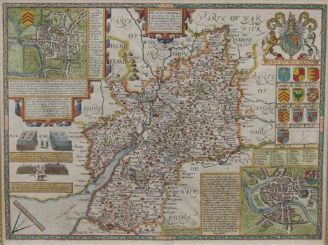
Lot 114
AFTER JOHN SPEEDE "Northamptonshire", a hand-coloured, double-sided map, bearing town plan for Northampton and Peterborow, bearing coat of arms of honourable families with table of county towns and English text verso, sold by Roger Rea The Elder and Younger at The Golden Cross in the Cornhill Exchange, image size 39.5 cm x 52 cm CONDITION REPORTS Overall with general wear and dirt, small tear to top border, tear and repair bottom centre, repaired tear to lower half slightly left of centre, picture is glazed front and back so that script to reverse is visible, script on the reverse can be seen slightly from the front of the map.

Lot 115
AFTER JODOCUS HONDIUS "The Countie and Citie of Lyncolne described with the armes of them that have bene Earles thereof since the Conquest", hand-coloured double-sided map bearing town plan for Lincolne and coats of arms, the description of Lincolneshire with table in English text verso, published by Thomas Bassett of Fleet Street and Richard Chiswell of St. Paul's Church Yard, circa 1610 CONDITION REPORTS Map is framed in double sided frame (glazed on both sides) so that script to back of map is visible. Map with some general wear and dirt. A few small holes near the cartouche. The script verso does show through slightly in places. Small tear to bottom border. A few old patched repairs visible verso, particularly along fold. A few areas of foxing and a patch repair a some very small holes to the Lincoln street plan. However, overall condition appears reasonably good.


Lot 630
A Geneva Bible, with maps and other illustrations, bound with The Newe Testament of out Lord Jesus Christ, Geneva, Printed by Rouland Hall, 1560, and The Booke of Psalmes, Collected into English Meetre Thomas Sternhold, John Hopkins and others, and with A Forme of Prayer to be used in priuate (sic) houses Euery (sic) Morning and Euening (sic), containing five maps including a loose city plan, calf (incomplete, sold w.a.f. not subject to return) See illustration Condition report Report by RB Side and bottom margins good, some cropping though to titles etc on top of pages, the first page in the book is To the Christian Reader, after which is a (later) hand written page The Names and Order of all the Bookes........, the corners to the front and rear of the book mostly are lacking, the last page in the book is A Prayer for the whole estate of Christ's Church, some pages with ink annotations, the binding with a few worm holes, corners bumped, spine weak, and with top and bottom of the spine incomplete Title page missing- Bible starts on iij Next page the incomparable treafure of the holy scriptures Next page names and order of all the bookes The First Boke of Mofes, Calles Genefis starts ai- none missing Seconde Boke Exodus starts page 24/fiiii- none missing Third Boke Leuiticus starts 45/Mi- none missing Fourthe Boke Nombers starts 59/Piii- Inbetween 77-78 is the mappe properly apperteineth to the 33 chap. of Nombres- none missing The Fifth Boke Deuteronomie starts 80/Viiii- none missing The Boke of Ioshva starts 96/Aiiii- inbetween 103-104 to the mappe doeth apperteine to the chap. 15 of Iofhva- none missing The Boke of Ivdges starts 108/Diiii- none missing The Boke of Rvth starts 119/Giii- none missing The First Boke of Samuel starts 121/Hi none missing The Seconde Boke of Samuel starts 135/Liii- none missing The First Boke of The Kings starts 148/Oiiii- none missing The Seconde Boke of The Kings starts 164/Siiii- none missing The First Boke of The Chronicles or Paralipomenon starts 178/Yii- none missing The Seconde Boke of The Chronicles starts 191/Bbiii- none missing 207 The Prayer of MA-naffeh King of the Lewes 207 EZRA The Argument Ffiii- none missing Nehemiah The Argument starts 212/Ggiii- none missing Ester The Argument starts 218/Liii -The Booke of Esther within The Argument has a different layout runs chap. j, iij and vvj. Normal number sequence returns on 221/Kki Iob The Argument starts 222/Kkii- none missing The Psalmes of David The Argument starts 235 -Page 237 has a large hole -Page 245 quarter length tear -none missing The Proverbes of Salomon 267/Xxiii- none missing Ecclesiastes or Preacher The Argument starts 266/&i- none missing An Excellent Song which was Salomons starts 280/&iiii- none missing Isaiah The Argument starts 282/&vi- none missing Ieremiah The Argument starts 306/Fffiiii- none missing Lamentacions starts 331/Nnn.i- none missing Ezekiel The Argument starts 333/Nnniii -Between 356-357 is a loose map of a city marked Occident at the top and Orient at the bottom -none missing Daniel The Argument starts 357/Trriii- none missing Hosea The Argument starts 365/Xxxiii- none missing Ioel The Argument starts 368/Yyyii- none missing Amos The Argument starts 370/Yyyiiii- none missing Obadiah The Argument starts 372/Zzzii- none missing Ionah The Argument starts 373/Zzziii- none missing Micah The Argument starts 374/Zzziiii- none missing Nahvm The Argument starts 376/Aaaaii- none missing Habakkvr The Argument starts 377/Aaaaiii- none missing Zephaniah The Argument starts 378/Aaaaiiii- none missing Haggai The Argument starts 379/Bbbbi- none missing Zechariah The Argument starts 380/Bbbb.ii- none missing Malachi The Argument starts 384/Cccc.ii- none missing Apocrypha The Argument starts 386/Cccciiii- none missing Tobit starts 405/Hhhh.iii- none missing Ivdeth starts 409/Iiii.ii- none missing Esther starts 416/Llllii- none missing The Wisdome of Salomon starts 417/Llll.iii- none missing The Wisdome of Iefus the Fonne of Sirach, Called Ecclefiafticus starts 424/Nnnnii- none missing Barvch starts 444/Sfff.ii- none missing The Song of the thr holie Children, which followeth third chapter of Daniel after this Place, Thei fell downe bound into the middes of the hote fyrie fornace starts 447/Tttt.i- none missing The Historie of Sufanne, which fome layne to the end of Daniel and make it the 13 chap starte 448/Ttttii- none missing The Historie of Bel and of the dragon, which is the fourtenth chapter of Daniel after the Laten starts 449/Ttttiii- none missing The First Boke of the Maccabees starts 450/Ttttiiii- none missing The Seconde Boke of the Maccabees starts 464/Zzzzii -474 has a hand written note, End of the AP...a Finis - none missing Next page- The Newe Testament of our Lord Jesus Christ (title page), with image at Geneva M.D.LX. Next page Description of the Holie Lane Next page (map) The Description of the Holie Lane and of the places mencioned in the foure Evangeliftes (also hand written present) Page after Map 2/AA.ii The genetacion The Holy Gospel of Lefus Chrift according to Matthewe - Page marked 1/AAi would appear to be missing unless unmarked. - all others present The Holy Gospel of Lefus Chrift according to Marks 17/EE.i- none missing The Holy Gospel of Lefus Chrift according to Luke 26/GGii -tear to 42/LLii -none missing The Holy Gospel of Lefus Chrift according to Iohn 42/LLii- none missing The Actes if the Holie Apoftles written by Like the Evangelifte 54/OO/ii- none missing Between 69/SSi and 70/SSii is a map of The Sea Mediterran The Epistle of of the Apoftle Paul of the Romaines The Argument- none missing The First Epistle of Paul to the Corinthians The Argument 76/TTiiii- none missing The Seconde Epiftle of Paul the Corinthians The Argument 83/xxiii- none missing The Epistle of The Apoftle Paul to the Galatians The Argument 87/yyiii- none missing The Epistle of Paul to the Ephefians 89/22/i- none missing The Epistle of Paul to the Phelippians The Argument 91/zz/ii The Epistle of Paul to the Colofsians 93/AAa.i- none missing The First Epistle of Paul to the Theffalonians 95/AAaiii- none missing The Seconde Epiftle to the Theffalonians 96/AAaiiii- none missing The First Epiftle of Pail to Timotheus The Argument 97/BBbi- none missing The Seconde Epiftle of Paul to Timotheus The Argument 99/BBb.iii The Epistle Of Paul to Titus 200/BBb.iii The Epistle of Paul to Philemon, Page 101/ CCci- none missing The Epistle to the Ebrewes 102/CCcii- none missing The General Epiftle of lames The Argument 106/DDdii- none missing The First Epiftle general of Peter the Argument 108/DDiiii- none missing The Seconde Epiftle general of Peter The Argument 110/EEeii- none missing The First Epiftle general of Iohn The Argumentt 111/EEe.iii- none missing The Seconde Epiftle of Iohn 113/FFf.i- none missing The Third Epiftle of Iohn and and The General Epiftle of Lude The Argument 113/FFfi The Revelation of Iohn the Divine The Argument 114/FFf.ii -page 122/HHh.ii has a hand written note in ink 'John Read his hand writing 1786...January the 14th Northamptonshire...' -none missing Next page a brief table of the interpretation of the propre names HHh.iii running into the firft table HHhiiii -LLliii marked with ink 'Franfes Searles, Booke minnifter' -none missing The Booke of Psalmes Veni Creator runs for five pages The Psalmes of David starting page 1 - pages 108 and 109 are missing, Sequence out we have two 110's, 111 and 112 are running, 114 missing A Forme of Prayer to be reed, runs for 2 pages, number of holes present one would appear to be missing, last page worn/ damages. The whole bible displays wear. All pages marked and discoloured to some degree.


-
109198 item(s)/page