We found 109198 price guide item(s) matching your search
There are 109198 lots that match your search criteria. Subscribe now to get instant access to the full price guide service.
Click here to subscribe- List
- Grid
-
109198 item(s)/page


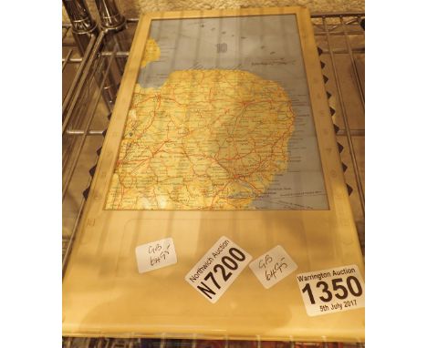


Lot 296
Christopher Saxton (England c. 1540- c. 1610). 'CESTRIAE', a 17th century hand coloured engraved map of Cheshire by William Hole, inscribed 'Comitatus (Romanis Legionibus et Colonijs olim insignis) vera et, absoluta descriptio', 32 x 26cm, in a later mounted, glazed Hogarth-type frame, together with another map of Cheshire inscribed 'CESTRIA COMITATUS PALATINUS'. (2)

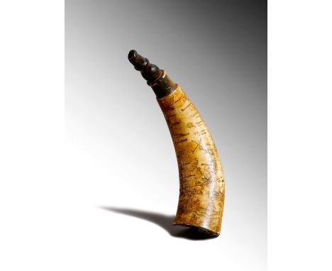
Lot 66
λ A rare mid-18th century Anglo-American map powder horn, scrimshaw decorated with a harbour, sailing ships and major settlements and forts, including: New York and Albany and with trade routes leading north to the Canadian lakes including the 'Hudson-Lake Champlain' route, also decorated with a compass, the British Royal Coat of Arms and a double banner indistinctly inscribed and possibly dated, 21cm long. In Colonial and Revolutionary times soldiers and hunters had to travel through unfamiliar lands and much of the region was unchartered with no maps. So it became common practice for well-known trade routes to be engraved on cow or ox horns. The powder horn such an important companion, then served a dual-purpose, to carry gun powder and to act as a guide. See Stephen Grancsay, American Engraved Powder Horns, A Study based on the J. H. Grenville Gilbert Collection, The Metropolitan Museum of Art, New York, for a full discussion of engraved powder horns and for similar examples, cat. nos. 28,29,30.


Lot 297
Joan Blaeu (Netherlands 1596 - 1673). A 17th century hand-coloured engraved map, of the French county Charolais, inscribed 'Les environs de L'ESTANG DE LONGPENDU, Comprenant une grande partie du COMTE de CHAROLOIS. Par Ican van Damme Sr. d'Amandale', in a later glazed double-sided frame, with a Latin text on the reverse, 50.5 x 38.6cm, together with 'VALESIUM Ducalus. VALOIS', also by Joan Blaeu.


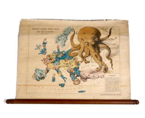
Lot 290
Fred Rose. A rare late Victorian 'Serio-Comic War Map For the Year 1877', lithograph with hand colouring, in scroll form, published by 'G.W.Bacon & Co. 127, Strand, London', 43 x 56.8cm. This rare anthropomorphic map was designed by Fred Rose and is a satirical commentary on the 'Eastern Question' and the geo-political situation of 1877. It depicts a fanciful map of Europe with each country represented by an appropriate figure. The main protagonist is Russia in the form of a giant octopus with its tentacles outstretched symbolising threat and advances to the Ottoman Empire. The Turkish figure aims a pistol at the octopus however one can see a skull inscribed 'Bulgaria' on the shoulder of the Turkish figure which symbolises the bloody war crimes the Bulgarians suffered at the hand of the Turks. Britain in the form of Gladstone is a keen but distant observer, Germany is a neutral observer, whilst Austria holds back its new ally Hungary from joining the conflict. Provenance: The Forde family, Wimbledon, London and by descent.


Lot 191
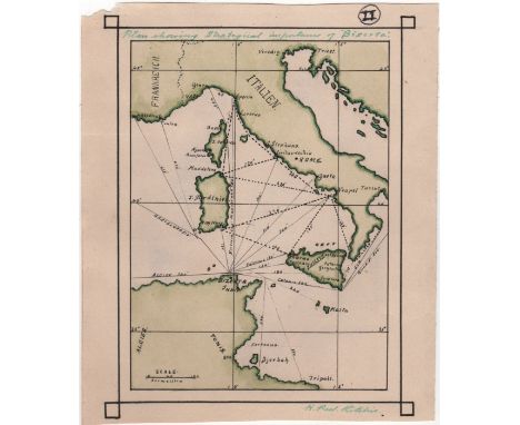
RITCHIE HENRY PEEL: (1876-1958) Scottish Royal Navy Captain, Victoria Cross winner for his actions at Dar-es-Salaam in November 1914. Ritchie received the first Victoria Cross awarded to Navy personnel in World War I. A good original colour pen and ink cartographic drawing signed ('H. Peel Ritchie'), one page, slim 8vo, n.p., n.d. (c.1893). The map drawn, in black, green and pale green inks, depicting southern Italy, Sardinia, Sicily, and the northern coast of Tunisia, with shipping routes and distances, entitled, 'Plan showing strategical importance of "Biserta"', in Ritchie's hand and signed by Ritchie at the base. The Roman numeral II has been written within a circle to top right edge. Light signs of former mounting to verso, and a slight tear to the top left edge. VG Bizerte (also known in English as Bizerta), a town of Bizerte Governorate in Tunisia and the northernmost city in Africa.


Lot 1531
ACWORTH (V. M.) - THE RAILWAYS of SCOTLAND Illustrated with folding map, half calf with marbled brds., also Murray's Timetables for the Railways, Steamboats, Coaches &c., 1866; The Highland RailwayCompany and It's Constituents and Successors 1855-1955 by The Stephenson Locomotive Society; The Wemyss Private Railway by A. W. Brothie and the Official Handbook of Stations, 4 vols.


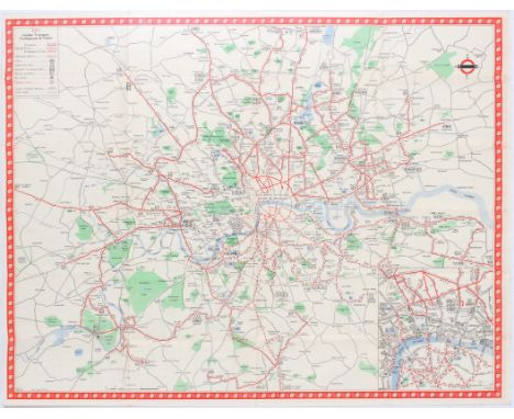
Lot 500
London Trolleybus & Tram Route Map With the Compliments of London Transport January 1950. Includes schedule of Trolleybus, map of all Trolleybus, Tram routes and Underground stations with legend including leaflet with amendments to the routes and times of first and last vehicles shown in Map. Good condition, dirt spots. Published by Waterlow & Sons. Country: UK. Year: 1950. Author: Hale. Size (cm): 57,5x44,5

Lot 401
London Trolleybus & Tram Map Of Routes No.1, 1946 London Passenger Transport Board. Includes schedule of Trolleybus, map of all Trolleybus, Tram routes and Underground stations with legend. Published by Waterlow & Sons. Good condition, dirt spots, marks from stamps.Country: UK. Year: 1946. Author: Fred. J. H. Elston. Size (cm): 57,5x44,5

Lot 402
London Trolleybus & Tram Map Of Routes No.1, 1947 London Passenger Transport Board. Includes schedule of Trolleybus, map of all Trolleybus, Tram routes and Underground stations with legend. Published by Waterlow & Sons. Good contition, one small tear on fold.Country: UK. Year: 1947. Author: Fred. J. H. Elston. Size (cm): 57,5x44,5

Lot 502
Welcome to London London Transport British Railways. London Festival of Britain 1951. Includes a map showing how to get to all festival sites using London Underground, Special Bus Services and Water Bus Services and a detailed plan of Southbank Exhibition. Good condition, folds, dirt marks. Country: UK. Year: 1951. Author: James Hart. Size (cm) (cm). 57,5x45
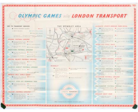
Lot 405
Olympic Games London 1948 How to get there by London Transport. Includes Diagram for London Railways (Central Area) and list of offices of the high commissioners, embassies and legations, consulates, abbeys and cathedrals, places of general interest, art galleries and museums in the legend. On the other side is presented a map of the Wembley area with list of football grounds and how to get there using any London Transport. Fair condition, tears on folds, dirt spots, marks from tape. Published by Waterlow & Sons. Country: UK. Year: 1948. Size (cm): 57x45

Lot 200
London Tramways Tramway Routes Map and Guide Winter 1923/24. Includes schedule of The London United Tramways and The Metropolitan Electric Tramways, Map of all tramway routes and Underground Railways with legend. Published by Eyre and Spottiswoode. Great condition. Country: UK. Year: 1923. Size (cm): 45x37

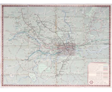
Lot 403
London Underground Diagram of Lines No.1, 1947 London Passenger Transport Board. Includes diagram of London Underground with legend and a diagram of connections with main line termini. Fair condition, water stains, dirt spots. Country: UK. Year: 1947. Author: H.C.Beck. Size (cm): 23x15. Henry Charles Beck (Leyton, London, 4 June 1902 – 18 September 1974), known as Harry Beck, was an English technical draughtsman best known for creating the present London Underground Tube map in 1931. Beck drew up the diagram in his spare time while working as an engineering draftsman at the London Underground Signals Office. London Underground was initially sceptical of Beck's radical proposal, an uncommissioned spare-time project, but tentatively introduced it to the public in a small pamphlet in 1933. It was immediately popular, and the Underground has used topological maps to illustrate the network ever since.
Lot 300
London Transport Underground Railway Map No.1, 1938. Icludes Map of London Underground with legend, Map of London Underground, Main Line Termini, Art Galleries, Museums, Buildings, Public Halls, Cathedrals and Churches with legend and a map of the city center with London Underground routes as well as Theaters and Cinemas with legend. Published by "Geographia". Fair condition, tears on folds, water stains, dirt spots. Country: UK. Year: 1938. Size (cm): 61x45


Lot 501
London Transport British Railways Elizabeth R Coronation Tuesday 2 June 1953. Includes a map showing Processional Route, the Coronation Area closed to vehicular traffic, small map of all London Transport Railways (Author: H.C. Beck) , full details of how to reach the route using public transport, private car or taxi. Very good condition, few stains. Country: UK. Year: 1953. Size (cm): 57x45
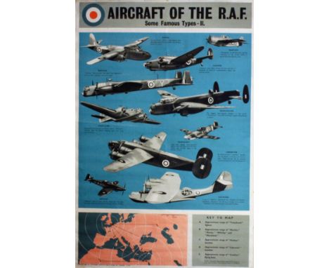
Lot 4413
Propaganda Posters WWII - Aircraft of the Royal Air Force. Original vintage World War Two poster: Aircraft of the Royal Air Force (RAF) - some famous types II photos of the planes with a map of their range. Havoc, Martlet, Hudson, Whitley, Manchester, Maryland, Tomahawk, Liberator, Defiant, Catalina. Printed for HM Stationery Office by Fosh & Cross, London. Good condition, light bumps on margins, small repaired tear.. Country: UK. Year: 1942. Author: . Size: 76x50.5cm.


-
109198 item(s)/page