We found 108737 price guide item(s) matching your search
There are 108737 lots that match your search criteria. Subscribe now to get instant access to the full price guide service.
Click here to subscribe- List
- Grid
-
108737 item(s)/page


Lot 81
A quantity of prints and engravings, including Batevia's Palace in the East Indies; Vue de la Riviere D'Endeavour; Baie de la Praya; Port du Roi Georges; Chinese merchants; Edinburgh; A bull tossing a dog; Cricket; Six chromolithographs of native scenes; A print after Redoute; A watercolour botanical study; A map dans la mer pacifique, all unframed, various sizes. (qty) CAB


Lot 273
Travel and Tourism posters, comprising; Picturing the South 1860- present, Exposition Nationale Suisse Lausane, 1964 High museum of art, Ski poster, 16-18th century costumes exhibition 2008, Island of Poros Greece, Bruges, Wonders of the Past tutankhamen, V&A power of the poster, Capitals of the common wealth, Aviators quick reference map, Swinbourne Railway, (a.f.), Alpes de France, (a.f.), The Famous London Transport Poster by E.Mcknight., (14). S4M

Lot 3326
James Bond paper ephemera, loose and in an album, including various sets of collectors cards, poster reproductions, photographs, Honor Blackman signed photograph with certificate, Ian Fleming Thriller map, limited edition Storyboard, postcards, newspapers etc Condition Report Click here for further images, condition, auction times & delivery costs


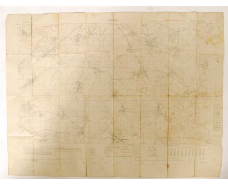
Lot 344
A rare WWI First World War British Army issued Somme ' Trench Map '. Dated January 1917 the map shows an area of France, with the British trenches mapped for reference. ' Trenches Corrected To 1-1-17 ' to top. Some added pencil markings, presumed to be those marking bomb craters are also present. Linen backed as issued. Fragile - upper left section torn at seam, but still attached. Measures approx 68cm x 90cm when opened.


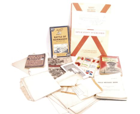
Lot 530
An incredible and very rare WWII Second World War RAF Royal Air Force Forward Air Controllers D-Day used Normandy Invasion Operation Overlord map. Pencil markings showing the invasion on the 6th June 1944. It is thought that the map is part of Operation Cobra which was part of the break out of Normandy beach head. Various areas and objectives can be clearly seein and all five D-Day beaches are marked. Most likely used on D-Day and the following weeks after in other operations. Comes 'as found' along with an original officers' map transit case which was recovered from an armoured car used by the RAF Forward Air Controls to call in air support to disable tanks and other targets. Incredibly rare used map. AF - one section torn away (but present). Map dated 1942. Measures approx; 60cm x 74cm

Lot 671
An interesting post-WWII Second World War Royal Navy related photograph album, likely that of a cadet, part-filled with various personal photographs of his experiences at sea. Includes views of; training, map reading, navigation, signalling, firing of guns, and other such photos. Likely China / Far East or similar region. Along with a copy of Jane's Fighting Ships (1941) and ' Sub-Lieutenant ' by Ludovic Kennedy.

Lot 552
A collection of original WWII Second World War and related RAF Pilot / Crew items and ephemera. To include; an original forage / side cap, a brass RAF cap badge, insignia patches, epaulettes, an interesting make-shift Training Record (typed to the reverse of a section of map). Most appearing to related to a 2053932 Gunner ' Staniforth '.

Lot 614
An original rare WWI First World War British Army issued folding Trench map of France / The Somme. Dated to August 1918, the map is highly details and shows the extensive network of trenches at that time. Areas shown include Peronne, Suzanne and Maricourt. An interesting period WWI map. Rare. 56cm x 84cm.
Lot 607
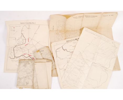
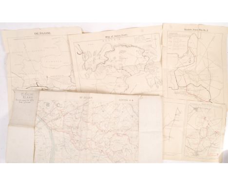
A collection of original WWI First World War era British Army maps. Various forms, including a folded linen backed Trench map of St Julian France 1917, a paper ' Map Of Italian Front,' ' Sketch Of Map No.2 To Illustrate The Action Of The Royal Munster Fusiliers,' 'Eastern Front Map 2', etc. Interesting collection.

Lot 42
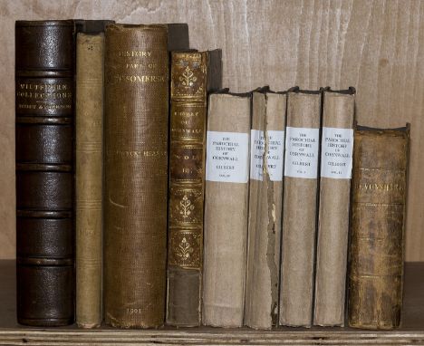
Wiltshire.- Cornwall.- Hoare (Sir Richard Colt) The History of Modern Wiltshire. Hundred of Westbury, 2 vol. bound in 1, hand-coloured map and engraved portrait plate frontispieces, 5 plates, tissue-guards, occasional off-setting, original paper wrappers, slight chipping to corners and extremities, 1830-31 § Gilbert (Davies) The Parochial History of Cornwall, 4 vol., half-titles, abrasion marks to front pastedowns, original cloth backed boards, rebacked, vol. 3 with broken spine, rubbed, 1838 § White (William) History, Gazetteer, and Directory of Devonshire, without map as usual, occasional faint spotting, contemporary calf, rubbed, bumping to corners and extremities, Sheffield, 1850; and 4 others, similar. v.s. (9)
Lot 27
Suffolk.- Gage (John) The History and Antiquities of Suffolk: Thingoe Hundred, first edition, hand-coloured engraved map frontispiece, 35 engraved plates and plans, occasional spotting, bookplate, ex-library with label to front pastedown, later half-morocco, rubbed, bumping to corners and extremities, 1838 § Copinger (W. A.) The Manors of Suffolk, 7 vol., plates, occasional marginal ink notes, original cloth, spine covering beginning to split (lower joint, vol. 2), rubbed and bumped, 1905-11, folio (8)
Lot 23
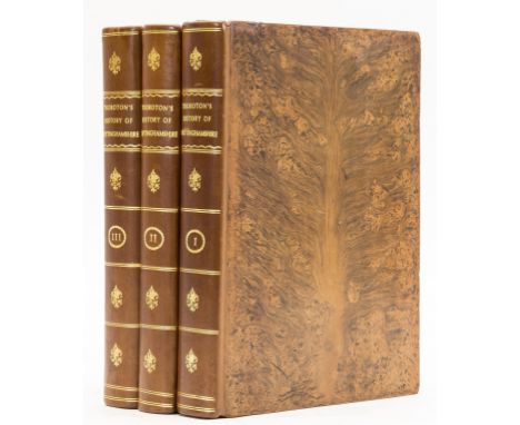
NO RESERVE Nottinghamshire.- Thoroton (Robert) The Antiquities of Nottinghamshire ... with large additions by John Throsby, 3 vol., second edition, 2 engraved portrait frontispieces, 1 engraved folding map frontispiece, vignette titles, 95 engraved plates (5 folding, 3 partially hand-coloured), 2 folding letterpress lists of Knights, occasional spotting, bookplates, previous owner's ink signature, contemporary tree calf, rebacked, slight bumping to corners, 4to, Nottingham, for G. Burbage, 1790.
Lot 15
Herefordshire.- Gloucestershire.- Duncumb (John) Collections towards the History and Antiquities of the County of Hereford, vol. 2 part 1 only, 3 engraved plates, occasional marginal water-staining, modern cloth, Hereford, 1812 § Rudge (Rev. Thomas) The History of the County of Gloucester, 2 vol., engraved folding map (tears, expertly repaired), 2 engraved plates, occasional ink and pencil annotations, occasional faint spotting, modern cloth, Gloucester, 1803 § Mortimer (William Williams) The History of the Hundred of the Wirral, 2 folding maps, plates, list of subscribers, occasional spotting, contemporary half-calf, slight bumping to corners and extremities, 1847; and 8 others, covering Shropshire and Staffordshire, v.s. (12)
Lot 61
NO RESERVE Australia.- Dutton (Francis) South Australia and its Mines..., 5 engraved plates, map, lacking large folding map issued with some copies, minor foxing to plates, endpapers lightly browned, original cloth, slightly marked, loss to portions of spine, T. and W. Boone, 1846 § Sherer (John) The Gold-Finder of Australia..., first edition, additional pictorial title, 48 wood-engraved plates, light spotting and finger soiling, original cloth, rubbed, bumping to corners and extremities, rebacked preserving original spine, [1853], 8vo (2)

Lot 19
Leicestershire.- Nottinghamshire.- Hill (John Harwood) The History of the Parish of Langton ... Leicestershire, additional chromolithographed title, plates, list of subscriber's, occasional spotting, bookplate, original cloth-backed boards, rubbed and worn, joints split, Leicester, 1867 § Cooke (G. A.) A Topographical and Statistical Description of the County of Leicester, bound before A Topographical and Statistical Description of Northamptonshire, engraved frontispiece, 2 folding engraved maps, 1 hand-coloured, 4 engraved plates, occasional spotting, [1830] § White (Francis and John) History, Directory and Gazetteer of the County ... of Nottingham, lacking map, occasional faint spotting, bookplates, contemporary calf, rubbed and worn, spine covering beginning to split, Sheffield, [?1844] § History, Gazetteer, and Directory of Cambridgeshire, lacking map, occasional faint spotting, previous owner's ink signature, contemporary half-morocco, rebacked with original spine laid down, rubbed and worn, Peterborough, 1851; and 7 others, similar, v.s. (11)

Lot 30
Sussex.- Dallaway (James) A History of the Western Division of the County of Sussex, including the Rapes of Chichester, Arundel, and Bramber ..., 2 vol. in 3, first edition, titles in red and black, 75 engraved plates and plans (1 plate trimmed and inset onto leaf, 6 double-page, 7 hand-coloured), 6 engraved maps (5 double-page or folding, 4 hand-coloured, 1 with tear), 3 folding pedigrees, illustrations, occasional spotting and off-setting, occasional faint pencil annotations, bookplates, contemporary calf, vol. 1 & vol. 2 part 2 rebacked, a little rubbed, 1815-30; The Parochial Topography of the Rape of Arundel in the Western Division of the Count of Sussex, vol. 2 part 1, second edition, engraved portrait frontispiece, list of subscribers, 21 engraved plates (1 bound upside down, 3 hand-coloured, 3 double-page), 1 double-page map, 2 pedigrees, occasional marginal annotations, bookplates. contemporary calf, rebacked, 1832; folio (4)⁂ Vol. 2 part 1 is scarce as much of the stock was destroyed by fire.

Lot 25
NO RESERVE Somerset.- Collinson (Rev. John) The History and Antiquities of the County of Somerset, 3 vol., linen backed hand-coloured folding map frontispiece, 40 engraved plates, half-titles, list of subscribers, occasional faint water-staining and spotting, bookplates, contemporary calf, a little rubbed, slight bumping to corners and extremities, 4to, Bath, 1791.

Lot 65
Europe.- Victoria (Queen) Leaves from the Journal of Our life in the Highlands, from 1848 to 1861..., edited by Arthur Helps, foxing and spotting to frontispiece and title, half vellum over green boards, spine gilt with celtic knots, 1868 § De Bovet (Madame) Three Month's Tour in Ireland, translated by Arthur Walter, first English edition, illustrations, some marking to title, original green decorative cloth, extremities a little rubbed, 1891 § Forbes (John) Memorandums made in Ireland..., 2 vol., half-title, frontispiece, illustrations, folding map, some ownership markings to pastedown, original green pictorial cloth, gilt, spines faded, a little worn, 1853, 8vo (4)

Lot 14
NO RESERVE Hampshire.- Warner (Richard) and D.Y., Collections for the History of Hampshire and the Bishopric of Winchester: Including the Isles of Wight, Jersey, Guernsey, and Sarke, 5 vol. bound in 3, engraved frontispiece and 60 plates (2 hand-coloured), 1 folding engraved map, bound without the 'Plan of the Form of Jersey' as usual, occasional spotting and off-setting, ex-library with usual stamps and labels, contemporary diced calf, rebacked, rubbed and worn, 4to, [1795].⁂ This work was only published in 5 volumes of the projected 6.

Lot 16
Hertfordshire.- Clutterbuck (Robert) The History and Antiquities of the County of Hertford, 3 vol., first edition, 54 engraved maps and plates, 1 map double-page, 2 plates hand-coloured, list of subscriber's, occasional spotting, bookplate, ex-library with labels to front free endpapers, contemporary morocco, gilt, rubbing to corners and extremities, folio, 1815-27.
Lot 12
NO RESERVE Durham.- Raine (Rev. James) The History and Antiquities of North Durham, first edition, engraved portrait frontispiece and 9 plates, 1 map, 2 pedigrees (1 double-page), occasional spotting, ex-library with 1 or 2 discreet ink-stamps, modern cloth, folio, 1852.⁂ With a large section on Holy Island, now known as Lindisfarne.


Lot 379
JOHANNES BLAEU, a mid-17th century hand-coloured map engraving of Gloucestershire; published in 1645 as Part IV of Theatrum Orbis Terrarum Sive Atlas Novus, Hogarth-framed and double-glazed (front and verso) (image size 42cm x 50cm) P. J. Booth, Cambridge House Gallery, Wiltshire, label verso


![AFTER JOHN SPEEDE; a black and white engraved map, 'The West Ridinge of Yorkeshyre [sic]', folded and later coloured, plate a](https://cdn.globalauctionplatform.com/c32a92b8-6ce8-4dbc-8e4d-ab58009809d2/13d026d5-1a7d-4c2f-8658-ab59009f4c2b/468x382.jpg)

Lot 625
HENRICI HONDÜ; a 17th century black and white map, 'Neapolitanum Regnum', plate approx 42 x 51cm, with text verso, 'Metio et Freitag'; a 17th century black and white map, 'Frisia Occidentalis', plate approx 39 x 48.5cm, with text verso, and Fer; a 17th century black and white map, 'Gallæcia Regnum', plate approx 37 x 48.5cm, with text verso, all three folded and unframed.


Lot 2117
J. Valentia regnum Contestani, Ptol. Edentani, Plin. Amsterdam, 1640, Mercator's map of Morea, Pierre Schenk, Europa excultissim, A New Map of Piedmont, the Duchies of Savoy and Milan and the Republic of Genoa: With Their Subdivisions From the Latest Authorities 1799, Colonies Francaises (en Amerique) mounted. A New map of America 1821, John Cary and A New Map of Africa 1819 ( mounted as wall maps ) Bartholomews XXth Century Citizens Atlas of the World.


-
108737 item(s)/page