We found 109182 price guide item(s) matching your search
There are 109182 lots that match your search criteria. Subscribe now to get instant access to the full price guide service.
Click here to subscribe- List
- Grid
-
109182 item(s)/page


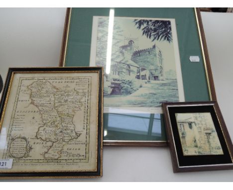
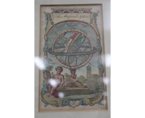
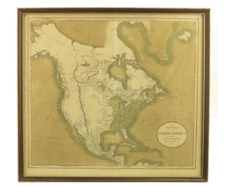
Lot 398
A DECORATIVE HAND COLOURED PRINT of the Ashmolean Museum, Oxford together with a print of the Geological Lecture Room Oxford, a map of Haarlem by Isaac Tirion c. 1742, a print of the interior of the Oxford Astronomical Observatory, a hand coloured book plate depicting 'The Artificial Sphere', further decorative pictures and prints (8)
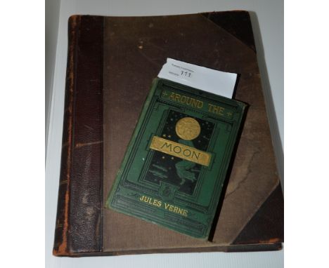
Lot 111
'Around the Moon' by Jules Verne dated 1876 authors edition with illustrations, published by Samson Low, Marsden, Searle and Ribbington - Crown Buildings 188 Fleet Street. 'New Large Scale Ordnance Map of the British Isles with plans of towns, copious letter press descriptions, alphabetical index's and census tables' edited and published by George W. Bacon


Lot 1680
A framed and glazed map of the Great Post Roads by Mostyn John Armstrong circa 1776, a map of Huntingdonshire by John Alken circa 1800, and improved map of Huntingdonshire by J. Cowley circa 1745, a map of Huntingdonshire drawn and engraved by J. Archer, another of Huntingdonshire by G Cole circa 1806

Lot 1681
A 17th century map of Bedfordshire by Robert Morden with coloured highlights - 36cm x 43cm - framed, an unframed map dated 1610 of Lyncoln - 45cm x 57cm after Jodocus Hondius, a framed strip map, an unframed map of Norfolk and three prints Condition report: All various conditions, colours good to maps


Lot 1058
Map of England and Wales worked by Amy A Warburton, Bruton, April 12th 1808, worked in chain stitch and cross stitch in coloured silks, 45cm by 54cm CONDITION REPORT: Backing cloth discoloured , numerous small holes and wear to the border especially in the bottom right hand corner, colours faded.

Lot 633
18th century embroidered cream silk Map of the Discovered World, within a floral border, black reverse glass mount and gilt frame, 75cm by 62cm (including frame) CONDITION REPORT: Several splits to the silks, mainly to the left and right hand sides. Several areas where silk has rubbed overall, fading to silks, discolouration to the silk, overall wear. Holes to the top of the frame, where it has been previously hung.

![[TOPOGRAPHY] Mogg, Edward. Paterson's Roads; being an entirely original and accurate Description of All the Direct and Princi](https://cdn.globalauctionplatform.com/bde9fddb-23c4-45f6-8942-a57500cc9f14/d2558a0c-eb70-43a8-f8aa-af36851e860a/468x382.jpg)
Lot 181
[TOPOGRAPHY] Mogg, Edward. Paterson's Roads; being an entirely original and accurate Description of All the Direct and Principal Cross Roads in England and Wales, eighteenth edition, for Rivington et al., London, no date [circa 1830], half leather, folding maps, octavo (upper cover detached; spine strip incomplete); and Bacon's folding Gem Pocket-Map of London and Suburbs, scale two inches to the mile, 48cm x 63cm, brown cloth covers, (2). Note: This lot sold with all faults, not subject to return.


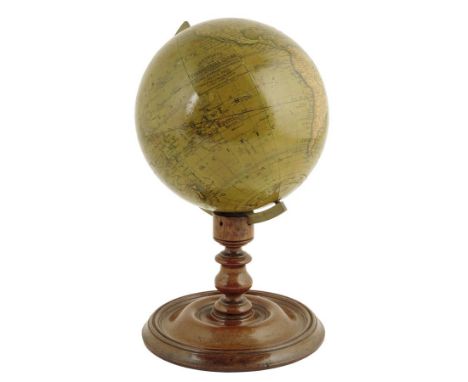
Lot 679
A Victorian six inch terrestrial globe by Cruchley, inscribed 'CRUCHLEY'S LATE CARY'S NEW TERRESTRIAL GLOBE SHOWING THE LATEST DISCOVERIES SETTLEMENTS, IN AUSTRALIA, NEW ZEALAND, CALIFORNIA & THE NORTH POLE G.F. CRUCHLEY, MAP-SELLER, GLOBE MAKER AND PUBLISHER 81, FLEET STREET, LONDON Additions to 1853', with a brass meridian ring on a turned mahogany base, 26cm high.

Lot 177
A George III hand-coloured mezzotint 'May-Day Morning', published 'August 26th 1794 by John Fairburn, Map, Chart & Printseller, No. 146 Minories London.', 24.7 x 35.2cm, in a glazed gilt and ebonized frame, the verso with a trade label for 'GRUNDY & SMITH'. Provenance: The Property of the Rt. Hon. Sir Mathew Thorpe.


![[Manuscript Map] ''A Plan of the Township of Lastingham, County of York'', indistinctly signed, pen and watercolour map with](https://cdn.globalauctionplatform.com/33e4f0c5-3917-4de5-8ffa-a5720112b35c/4021f9c2-455b-4119-d6a7-2fa4e910c4a3/468x382.jpg)


![[Blaue (J.)] Westmoria Comitatus, Anglice Westmorland, 17th century, hand-coloured engr. map, 380x500mm, framed and glazed (](https://cdn.globalauctionplatform.com/33e4f0c5-3917-4de5-8ffa-a5720112b35c/089be7f1-ea1e-4780-e176-4d70aa9fec76/468x382.jpg)

Lot 134
Forster (Westgarth) Treatise on a Section of the Strata …, 1821, 11 plates and folding table (table torn), boards (worn); Marsden (W.) History of Sumatra, 1784, 2nd Edition, quarto, folding map (lacks plate and pp. IX-XII); Wordsworth (W.) The White Doe, 1815, quarto, frontis (lacks half-title) and four other volumes, misc (7)

Lot 143
Legal ephemera and documents, etc, including - 1877 Patent Grant to Henry Garth, re alcohol extraction from locust beans; on vellum with large wax seal in tin (a/f); - a part-used 1830's cheque book for Harrison, Watson & Co, Hull; - vellum counterpart (with map) for lease of South Friendship Mine at Mary Tavy, Devon (and 2 related deeds); - printed acts and sundry other material (qty)
![Holy Bible [The Holy Bible] 4to in 8's [290x180mm] black letter bible with later general title of 1629, but with ''The Volum](https://cdn.globalauctionplatform.com/33e4f0c5-3917-4de5-8ffa-a5720112b35c/c32910fe-1f67-403f-8386-db6e6877a4d1/468x382.jpg)
Lot 147
Holy Bible [The Holy Bible] 4to in 8's [290x180mm] black letter bible with later general title of 1629, but with ''The Volume of the books called Apocrypha'', dated 1584 (at f.368), colophon at end for ''Christopher Barker Printer to the Queenes Maiestie'', undated; the prelims begin with ***iii (-[viii]), 6 viii, c viii (the latter a large woodcut of Eden) 578 ff., numbered except 198 ''A verie profitable declaration'', 226 ''The Psalter'' part-title, 369 ''Apocrypha'' part-title, 460 ''New Testament'' part-title, 461 ''Description of the Holy Land''; ff. 70, 125, 326, 434, 444 & 5, 486, 567 & 578 misnumbered; woodcut initials etc, and ''cosmographie'' map verso f.529; margins red rubricated throughout; margin repairs to ff.530, 546, 577 & 8; bound in 17th c style black morocco gilt, metal corner pieces (upper cover detached, clasps gone) Provenance: large armorial bookplate of Martin Stapylton laid in
![[KENT] PRICE (Daniel) A System of Sheep-Grazing and Management as Practiced in Romney Marsh, 1809, quarto, map frontis, 11](https://cdn.globalauctionplatform.com/33e4f0c5-3917-4de5-8ffa-a5720112b35c/0759cda9-d973-40c6-8d17-0bb286c491ac/468x382.jpg)
![[ANON] Guide to the Lakes in Cumberland, Westmorland and Lancashire, 1784, Printed for B Law, 3rd Edition Enlarged, 8vo, fol](https://cdn.globalauctionplatform.com/33e4f0c5-3917-4de5-8ffa-a5720112b35c/868a409f-b2a4-4505-a094-4225451a1e1a/468x382.jpg)
Lot 69
[ANON] Guide to the Lakes in Cumberland, Westmorland and Lancashire, 1784, Printed for B Law, 3rd Edition Enlarged, 8vo, folding map and 1 plate (of Grasmere), contemporary mottled calf, a.e. yellow, contemp. bookplate of Jas. Clealand; Black's Road & Railway Travelling Map of Scotland, folding h-col'd linen-backed map, ca.1860 (2)

Lot 77
Hunter (Joseph) South Yorkshire, 1828, 2 vols folio bound in 1, portrait, 2 double-page h-coloured maps, 15 plates (incl. a single-page map), vignettes, half calf (binding distressed, covers off); together with Frost (Charles) Notices relative to the Early History of … Hull, 1827, quarto, 7 plates, bound (rebacked and recased) (2)


Lot 96
Falkland Islands a collection of 7 maps, including: Bowles's New one Sheet Draught of Falkland Islands ..., n.d., (18th c), Bowles and Carver, hand-coloured engraved map, central fold, 450x690mm, framed and glazed; Ledge (J.) engraver: A Map of the Falkland Islands, 1770, hand-coloured engraved map from the Gentleman's Mag., folds, 170x240mm, framed and glazed


Lot 1449
Books - Robertson-Glasgow (R.C.), Cricket Prints: Some Batsmen and Bowlers 1920-1940; "Geographia": Map of Lancashire & Yorkshire; other maps; Bunyan, The Pilgrim's Progress, Burslem 1814, full calf; Penguin Books Agatha Christies; Queen's Book of the Red Cross; Victorian half-leather bindings; etc
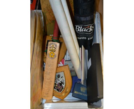
Lot 1274
A Derbyshire County Cricket Club miniature bat, signed by the team; a London Transport Bus Map: Central Area, 1937; another, Underground Railway Map, 1938; Loughborough University armorial plaque, shield back; another, similar; Blacks Tripod Stool, carrying back en suite; maps; transport; ephemera; etc


-
109182 item(s)/page