We found 109182 price guide item(s) matching your search
There are 109182 lots that match your search criteria. Subscribe now to get instant access to the full price guide service.
Click here to subscribe- List
- Grid
-
109182 item(s)/page


Lot 282
Two British WWII campaign medals, 1939-45 war medal unnamed, and a 1939-45 defence medal George VI unnamed. In appearing original box of issue, addressed to D L Price of Cardiff, together with an ARP warden's badge, an RAF cap badge, a grenadiers cap badge, and a plated metal map scaler. (B.P. 21% + VAT) D L Price Esq. Bridge House, 88 Merthyr Road, Whitchurch, Cardiff. Address on a white sticker. Underside of box is marked Air Ministry, London, W C 2.

Lot 371
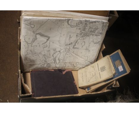
Box of various ephemera including 1956 ordinance survey map of Cardiff, Swansea Street Plan, Decorators materials etc. Catalogue from a French Exhibition in 1974, Tableaux Cubisets Abstraits and Surrealistes, Chritian Grandin, Book of newspaper cuttings, adverts, postcards etc. Volumes of The Locomotives Journal from 1960's and 70's, packet of postcards, electricians handbook, copy of Review of Review's Illustrated 'The Chance of Russian Recardo' by W T Stead ,postcard of Boeing 747 , postcard possibly dating 1920 the Thames Near Charing Cross, another of Promenade Fleetwood, local interest postcards. A string of Scrabble lights. (B.P. 21% + VAT)


Lot 1936
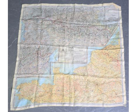
A Second World War period silk escape map, one side printed with 'Sheet A, France, Belgium, Holland', the other with 'Sheet B, France, Spain, German-Swiss Frontier', 73cm x 73cm, together with a group of other silkwork items, including a scarf embroidered to the Queen's Own Cameron Highlanders.Buyer’s Premium 29.4% (including VAT @ 20%) of the hammer price. Lots purchased online via the-saleroom.com will attract an additional premium of 6% (including VAT @ 20%) of the hammer price.

Lot 941
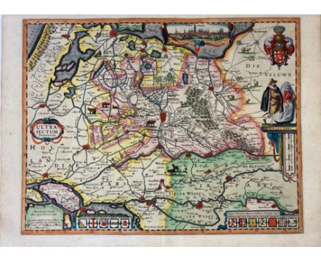
BESCHREIBUNG, Ausführliche und Grundrichtige, Der Freyvereinigten Staaten und Spannischen Niederlanden, In Gewisse und sonderbare XVII. Länder abgetheilet. Namentlich vier Hertzogthümer: Gelderland, Braband, Limburg, Lüxenburg. Eine Marggraffschaft: Antwerpen. Sieben Grafschafften: Holland, Seeland, Zütphen, Flandern, Artois, Hennegau, Namur. Und fünf Herrschafften oder Herrlichkeiten: Utrecht, Ober-Issel, Friesland, Gröningen, Mecheln (...). Frankf./Lpz., C. Riegel, 1691. (8), 1078, (10) pp. W. double-p. engr. front., 120 engr. plans & views. Old vellum bind. w. ties. (Bind. dam./rep., front. soiled & rep. on v°, rather browned/foxed in places). NOTE:First edition of this topographic and historical description of the Netherlands with the typical mini engravings by Riegel. Contains views of i.a. Aalst, Arnemuiden, Bergen op Zoom, Brugge, Duinkerken, Grave, Groningen, Hasselt, Lier, Mechelen, Leeuwarden, Namur, Nijmegen, Oudenaarde, Rotterdam, Stavoren, Zierikzee, Zutphen and Zwolle. - Rare. - VD17 39:107693D. The map announced on the title-page is lacking in all the known copies.


Lot 945
BRABANT -- LE ROY, J. Le grand theatre profane du duché de Brabant, contenant la description générale & abregée de ce païs; (…) nommément dans les territoires de Louvain, de Brusselle, d'Anvers, & de Bois-le-Duc (…). The Hague, C. v. Lom, 1730. 2 in 1 vol. (4), 64; (4), 151, (1 blank), 11 pp. W. engr. ti-vign., 4 engr. plates w. coat of arms (3 nicely cold. by hand), 1 engr. plate w. seals, 1 engr. map & 188 engrs. (incl. 4 plans) on 67 plates, mostly depicting castles (w. almost all small coat of arms cold. by hand) & 4 engr. coat of arms in the text, also cold. by hand. Fol. Cont. cf. w. raised bands, richly dec. gilt back & red label. (Some minor foxing in places, else a fine copy). NOTE:The work is divided in four parts: Louvain, Brussels, Antwerp & Bois-le-Duc, all with a separate plate-section. The second part has a separate title: "Le grand theatre profane du Brabant-wallon". - First French edition. - Bibl. Belg. III, 854ff; Tiele, 653 (note).

Lot 872
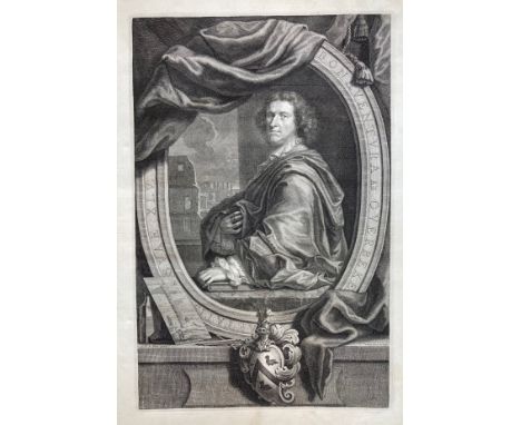
ROME -- (OVERBEKE, B. ab. Reliquiæ antiquæ urbis Romæ. Amst., J. Crellius, 1708). Engr. portrait of the author by C. Vermeulen after J.C. le Blon, engr. dedicated to Queen Anna by M. Pool, engr. allegorical front. by M. Pool, fold. engr. map by M. Pool, and 143 (of 146) engr. plates, one dep. the Collosseum large fold. Fol. (Bind. and all texts lack, (blank) margins stained throughout, worsening a bit towards end (w. even some moulding to blank margins of some lvs.), split in fold. map/small tear in portr., both w. clumsy rep. on v°). NOTE:Bonaventura van Overbeek (1660–1705) was born and died in Amsterdam. According to Houbraken, he drew the Roman ruins from life and, while in Rome, he joined the Bentvueghels with the nickname Romulus. The 'Reliquiæ' is a book with descriptions of the major sites of Rome. Lacking all text and plates a24, a25, a34. Although the plates are in fact in very good condition, the work is sold w.a.f. as a collection of plates. - Kissner Coll. 318; Graesse V, 66.

Lot 221
WATER MANAGEMENT ENGINEERING -- SIMONS, G. & A. GREVE. Verhandeling over de stoombemaling van polders en droogmakerijen. 1844. 4°. Clothbacked brds. -- H. WORTMAN. & J. v.d. BROEK. Geschiedenis en beschrijving v.h. Noordzeekanaal. 1909. W. 21 plates & fold. cold. map. Fol. Clothbacked brds. (Ex libr. copy). -- L.A. REUVENS. De Waal- en Rijn-dijken der polderdistricten in Gelderland en de werken tot verbetering der daarlangs gelegen rivieren. 1871. W. double-p. ti-p. & 37 (of 38) double-p. lithogr. maps. Lge-fol. Or. printed brds. (Bind. stained/soiled, spine and 1 plate gone). -- P. BROUWER & W. EEKHOFF. Nasporingen betrekkelijk de geschied. der voormalige Middelzee in Friesland. 1834. W. fold. cold. map. Cl. -- And 6 o. (smaller) works. (10).


Lot 346
BELGIUM -- "BELGIUM sive Inferior Germania". Amst., (1628). Engr. handcold. map by J. Janssonius after G. Mercator, from "Atlas Minor". 125 x 176 mm. Latin text on v°. Under passepartout. (Slightly browned). Koeman, Me 194. -- "COMITATIS Flandria". (Amst., 1630). Engr. map by J. Janssonius after G. Mercator, from "Atlas Minor", newly engr. by A. Goos. 125 x 176 mm. German text on v°. (Margins a bit stained, slightly browned). Koeman, Me 199. -- And 5 o. small maps of Belgium/Flandria. (7).
Lot 415
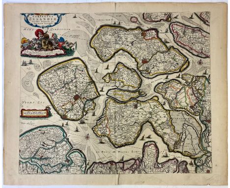
LOW COUNTRIES -- ZEELAND -- "COMITATUS ZELANDIÆ Novissimæ Delineatio per Nic. Visscher". (Amst.), N. Visscher, n.d. (after 1672, before 1719). Engr. map in cont. hand colouring w. scale indicator and large cartouches in upper left corner. 460 x 550 mm. (Small tear in lower margin (former rep. on v°), partly affecting image, some splits in places, but a good copy). -- Added: "UTRAQUE BEVELANDIA, & Wolfersdyck, Insulæ Orientaliores Zelandiæ Cisscaldinæ; Vernacule, De Oostelycke Eylanden van Bewester-Scheld". (Amst., Blaeu, 1662). Engr. map in cont. hand colouring w. large title cartouche. 430 x 560 mm. -- (2). NOTE:Ad 1: Blonk-v.d. Wijst 42, third state. - Ad 2: Id. 43B.


Lot 417
LOW COUNTRIES -- ZEELAND -- ("ZEELAND"). (Amst.), C.J. Visscher, 1631. Plain engr. map of Zeeland w. compass rose, scale indicator, 2 ships in full sail at sea and 2 puppets. 350 x 470 mm. (Slightly foxed, repair in lower upper right blank corner, but a good copy). NOTE:Similar to V.d. Krogt 3600:364, but later issue; Blonk-v.d. Wijst 18.7.
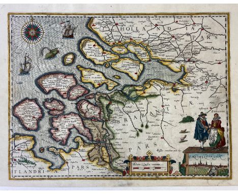
![LOW COUNTRIES -- "BELGII inferioris descriptio emendata cum circu[m]iacentiu[m] regionum confiniis". N.pl., n.d. (c. 1600?).](https://cdn.globalauctionplatform.com/e6945d44-49f2-46cf-825d-ae6a00d8e548/ea9b6103-280f-4ba1-9130-ae6a00e58ba1/468x382.jpg)

Lot 376
LOW COUNTRIES -- CHARTS -- "PASCAERTE vande Noord-Zee Nieulix Wtgegeven". Amst., J. Colom, n.d. (1651). Cold. chart (Restored, margins short, small defects in places). -- Added: "CUST van Hollant tusschen de Maes ende Texel". Amst., P. Goos, c. 1650). Cold. engr. map. 425 x 525 mm. (A bit foixed, repair (?) on v°-side). -- (2).

Lot 347
BELGIUM -- "BRUGÆ, Flandricarum Urbium Ornamenta". (Cologne, Braun & Hogenberg, n.d., c. 1610). Cold. engr. plan in bird's eye perspective. 322 x 462 mm. (Part of left and right outer margin replaced). V.d. Krogt 661. -- Added: "COMITATUS FLANDRIÆ Accuratissima Descriptio, (…)". Amst., C. Allard, (c. 1700). Engr. map in cont. hand colouring. 465 x 560 mm. In very good condition. -- (2).

Lot 387
LOW COUNTRIES -- GELDERLAND -- "DUCATUS GELDRIÆ ET ZUTPHANIÆ COMITATUS". (Amst.), N. Visscher, c. 1690. - "NOVISSIMA COMITATUS ZUTPHANIÆ (…)". (Amst.), N. Visscher, c. 1690. - 2 engr. maps in cont. colouring, cities ornated w. golden dots. c. 475 x 572 mm. (Margins slightly stained, repairs in places). -- Added: "DUCATUS GELDRIÆ et comitatus Zutphaniæ nova tabula in Tetrarchias Noviomagi, Arnhemii, Ruremondæ et Zutphaniæ distincta et edita". Amst., Covens & Mortier, n.d. (c. 1750). Cold. engr. map by Condet. In fine condition. -- (3).


Lot 408
LOW COUNTRIES -- UTRECHT -- "CAERTE VANDE VRYHEYD DER STADT UTRECHT volgens Decisie vanden Iare 1539". (Amst.), J. Ottens, n.d. (between 1708 and 1719). Plain engr. map above a strip of letterpress text - to which the map is connected - w. the following header: "Uitspraek over de jurisdictie der Stad Utrecht, in dato den 20. Augustus 1539". 373 x 526 mm (map only), 485 x 587 mm (total size). (A bit rumpled and some small rep. on v°, but in good condition). NOTE:2nd state w. the strip of text, often lacking. Donkersloot-de Vrij, Kaarten v. Utr., 140-2.

Lot 608
BUDDINGH, S.A. Neêrlands-Oost-Indië. Reizen over Java, Madura, Makasser (...) gedaan gedurende het tijdvak van 1852-1857. 2e uitg. Amst, Wed. J.C. v. Kesteren & Zn, 1867. 3 vols. (6), 415; (6), 415; (8), 445 pp. W. tinted lithogr. front.-portr., fold. cold. lithogr. map, 27 cold./tinted lithogr. plates. Lge-8°. Old brds. (A bit foxed/browned, some marg. stains). NOTE:Bastin/Brommer 575-577: "This is more than a travelogue, containing as it does information on a wide range of subjects skilfully interwoven into the narrative (...) The combination of an interesting and informed text with so many coloured plates makes Buddingh's Neêrlands-Oost-Indië one of the handsomest of Dutch nineteenth century travel books". - Cat. NHSM I, 248; Landwehr, Dutch books w. cold. plates, 247; Rouffaer/Muller p. 4; Tiele 214.

Lot 345
BALTIC SEA -- "DUCATUS POMERANIÆ novissima Tabula (…)". Nuremberg, J.B. Homann, n.d. (c. 1720). Engr. map of the Baltic coast between Stralsund and Danzig, in cont. col. 500 x 575 mm. -- Added: "REGNI BORUSSIÆ (…)/CARTE NOUVELLE de Royaume de Prusse (…)". Amst., J.B. Elwe, 1792. Engr. map of the Baltic coast between Schlawa and Memel w. inset plan of Koningsberg and surroundings in cont. col. 465 x 622 mm. (Lower blank margin stained). -- (2).

Lot 440
POLAND -- "TRACTUUM BORUSSIÆ, circa Gedanum et Elbingam, ab incolie Werder appellati; cum adiuncta Neringia, nova et elaboratissima delineatio". (Amst., Blaeu, 1662). Plain engr. map of the region around Dantzig, Ellbing and Marienberg. NOTE:In fine condition, Latin text on v°. V.d. Krogt 1725:2.
Lot 833
MACROBIUS. In somnium Scipionis M. Tulii Ciceronis libri duo et Saturnaliorum Lib. VII. Par., J. Badius, 5 Nov. 1524. (6), 112, 9, (1) lvs. Title within woodcut historiated border with Badius printing press device, 13 woodcut text-ills., incl. repeats, 4 diagrams & zonal world map on D4r, dec./historiated initials throughout. - Bound after: AULUS GELLIUS. Noctium Atticarum libri undeviginti. Par., J. Badius, Oct. 1524. (8), 136, (6) lvs. Title in red & black within woodcut historiated border with Badius printing press device, & dec./historiated initials throughout. - Bound before: PETRUS CRINITUS. De Honesta Disciplina Lib. XXV, De Poetis Latinis Lib. V, et Poematon Lib. II. Par., J. Badius, Oct. 1525. (8), 109, (1) lvs. Title within woodcut historiated border with Badius printing press device, & dec./historiated initials throughout. - 3 works in 1 vol. Fol. 17th c. brown red full mor. w. raised bands, gilt dec. spine, gilt dec. coat of arms of the city of Marseille on both sides, mottled edges. (Hinges skilfully rep., headbands renewed, ti-p. of Gellius cut out and laid down, lower outer corner a bit stained, slightly browned, else a fine and well-preserved copy). NOTE:Ad 1: Second Badius edition of an early 5th century A.D. treatise on Neoplatonic philosophy in the form of a commentary on Cicero's Somnium Scipionis, with extensive incidental remarks on cosmology and the sciences. Also included are the Saturnalia by Macrobius, a dialogue on various subjects set at a banquet during the Saturnalian festival; and De die natali by Censorinus, on miscellaneous topics relating to conception, birth, and chronology. Fine example of the earliest edition of Macrobius' important Medieval world map, first published in Brescia in 1483. - Renouard, Badius Ascensius III, 55-3. Not in Adams. Ad 2: Second Badius edition. - Renouard, Badius Ascensius III, 466-5. Not in Adams. Ad 3: Second Badius edition. - Renouard, Badius Ascensius III, 353-6. Adams C-2951. Copy with handwritten school prize (with seal of the college) to Joannes Baptista Leotardo for the first prize in rhetorica, signed by Priest Mignot, Head of the College in Marseille, 1673. On first free endpaper in old manuscript: Ex dono Honorati Leotardi, famous Italian jurist (?-1650). From the library of Leo S. Olschki and with his bookplate.

Lot 1002
CHINA -- ANVILLE, J.-B. BOURGUIGNON D'. Nouvel atlas de la Chine, de la Tartarie chinoise, et du Thibet: Contenant les cartes générales & particulieres de ces pays, ainsi que la carte du royaume de Corée. The Hague, H. Scheurleer, 1737. 12 pp. W. 42 fine engr. maps (of which 12 fold./double-p.). Lge-fol. Cont. h. goatskin, uncut. (Spine ends a bit dam., spine rubbed/chafed, corners bumped/worn, slightly browned/foxed in places, but a good and clean copy). NOTE:Second European Atlas of China (Blaeu's Atlas Sinensis is the first) by the famous French mapmaker, Anville. He drew the maps at request of the Jesuits for du Halde's "Description de la Chine" (1735). This atlas constitutes the first scientific mapping of China, as it is based on triangulation nets in a period when a more scientific approach was being given to the subject. This atlas was the result of a collaboration between the French Jesuits and the Chinese under the Emperor K'ang-hsi. The atlas is also important for early cartographic representations of Tibet and Korea, as well as the first map to illustrate Bering's first voyage (to Kamtschatka) and Russian Alaska. - Cordier, Sinica, 48; Lust 155; Koeman, Anv. 1.
![LOW COUNTRIES -- FRIESLAND -- "NIEUWE BESCHRIJVI[N]GE VAN OOST EN WEST VRIESLA[N]T door Davidt Fabricio van Esentz soe wel vo](https://cdn.globalauctionplatform.com/e6945d44-49f2-46cf-825d-ae6a00d8e548/b0758e9c-0bbe-4c9a-8f28-ae6a00e5b496/468x382.jpg)
Lot 384
LOW COUNTRIES -- FRIESLAND -- "NIEUWE BESCHRIJVI[N]GE VAN OOST EN WEST VRIESLA[N]T door Davidt Fabricio van Esentz soe wel voor water als te lande neerstelijck beschreven. (Amst.), P. Kaerius, 1617 (= c. 1622). Handsomely cold. engr. map of the provinces Friesland, Drenthe and Groningen w. 2 compass roses, scale indicator, several ships in full sail at sea and 2 coats of arms. 382 x 495 mm. NOTE:Van der Krogt 3900:364:02.


Lot 445
SCHRÆMBL -- COLLECTION of 26 large engraved maps from the 'Allgemeiner großer Atlas', partly coloured in outlines, all loose as issued and untrimmed. (Vienna), F.A. Schræmbl, (1786-90). c. 630 x 885 mm each (sheet size). (In very good condition, but w. here and there some splits in blank margins). NOTE:The collection comprises i.a.: "KARTE von Süd-America". 1786. W. inset map of the Falkland Islands. On 3 sheets which can be conjoined. -- "SPECIALKARTE der West-Küste von Africa von Caboblanco bis Cabo Verga". 1786. On 2 sheets which can be conjoined. -- "ERSTER THEIL der Karte von Europa, welcher Frankreich, Deutschland, Italien, Spanien, (etc.) enthaelt". 1790. On 2 sheets which can be conjoined. -- "ZWEITER THEIL der Karte von Europa welcher Dænemark, und Norwegen, Schweden und Russland enthaelt". 1787. On 2 sheets which can be conjoined. -- "ERSTER THEIL der Karte von Asien welche die Türkei, Arabien, Persien, Indien (…) und einen Theil der Tatarei enthält". 1786. On 2 sheets which can be conjoined. -- "DRITTER THEIL der Karte von Asien, welcher Siberien und einige andere Theile der Tatarei enthält". 1787. On 2 sheets which can be conjoined. -- "GENERALKARTE der Koenigreiche Marokko, Fez, Algier, und Tunis". 1789. -- "GENERALKARTE von Siebenbürgen". 1789. On 2 sheets which can be conjoined. -- "KARTE von den N.W. Amerikanische und N.Oe. Asiatischen Küsten". 1788.
Lot 416
LOW COUNTRIES -- ZEELAND -- ("ZEELAND"). (Amst.), C.J. Visscher, 1631. Engr. map of Zeeland in cont. hand colouring w. compass rose, scale indicator, 2 ships in full sail at sea and 2 puppets. 350 x 470 mm. (Professionally restored). NOTE:Similar to V.d. Krogt 3600:364, but later issue; Blonk-v.d. Wijst 18.7.
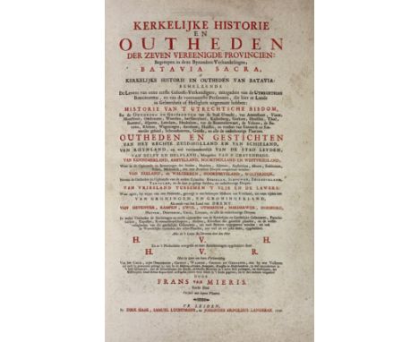
Lot 911
H(EUSSEN), H. v. Kerkelijke historie en outheden der Zeven Vereen. Provincien. In 't Nederduits overgeset d. H. v. R(ijn). Leyden, D. Haak, S. Luchtmans & J.A. Langerak, 1726. 6 vols. W. 1 large fold. engr. map of Zeeland and 6 fold. bird's eye plans of cities in Zeeland, 1 bird's eye view of Utrecht, 26 (fold.) views/plates, 24 mainly fold. portraits, num. ills. and portraits in text. Fol. Cont. h. goatskin, uncut. (Corners bumped/worn, rather foxed/browned in places). NOTE:Dl. 1: Batavia Sacra, of kerkelijke historie & outheden van Batavia: behelzende de Levens van onze eerste Geloofsverkondigers (…); Dl. 2: Historie van 't Utrechtsche bisdom; Dl. 3: Oudheden en Gestichten van het rechte Zuid-Holland en van Schieland; Dl. 4: Oudheden en Gestichten van Kennemerland, Amstelland, Noordholland en Westvriesland/Oudheden en Gestichten van Zeeland; Dl. 5: Oudheden en gestichten van Vriesland/Oudheden en gestichten van Groningen en Groningerland; Dl. 6: Oudheden en Gestichten van het Bisdom van Deventer/F. v. Mieris. Beschryving der Bischoplyke munten en zegelen. - Haitsma Mulier/v.d. Lem 222.

Lot 439
POLAND -- "REGNI POLONIÆ et Ducatus Lithuaniæ, Voliniæ, Podoliæ, Ucraniæ, Prussiæ, Livoniæ et Curlandiæ. Descriptio, emendata per Joannem de Ram". (Amst., 1685). Engr. map in cont. col., w. cartouche. 395 x 314 mm. v° blank. (Lower blank margin split/rep. on fold, fold strengthened on v°). -- "REGNI POLONIÆ magnique ducatus Lithuaniae nova et exacta tabula ad memtem Starovolcy descripta". Nuremberg, (1739). Engr. map by J.B. Homan in cont. col., w. large cartouche. 490 x 550 mm. v° blank. (Fold rep. on v° and in margin, margins a bit stained/soiled in a few places, fold a bit browned). -- (2).

Lot 294
NANSEN, F. Farthest North. Being a record of a voyage of exploration of the ship Fram 1893-96 and of a fifteen months' sleigh journey. (2nd Engl. ed.). Lond., G. Newnes, 1898. 2 vols. xv, 480; viii, 456 pp. W. num. ill. & fold. map. Or. silver and gilt pictorial cl., a.e.g. (W. handwritten dedication on half-ti., spines a bit soiled, extremities slightly bumped, but still a good set).
Lot 403
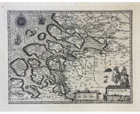
LOW COUNTRIES -- "NOVUS XVII INFERIORIS GERMANIÆ PROVINCIARUM TYPUS de integro multis in locis emendatus à Guliel. Blaeu". Amst., W. Blaeu, (1662). Engr. map, cold. by hand, w. large title cartouche, a compass rose, several ships at sea and sea monsters. 405 x 514 mm. NOTE:Third state, text in Latin on v°. In good condition. - V.d. Krogt 3000:2.2; Van der Heijden 64.2.

Lot 380
LOW COUNTRIES -- "DESCRIPTIO GERMANIAE INFERIORIS". (From Guicciardini 1581/82). Engr. map. 235 x 320 mm. Guicciardini Illustratus Nederlanden-3; Van der Heijden 24. -- "DESCRIPTIO GERMANIAE INFERIORIS". (c. 1593). Engr. map in old handcol. by Fr. Hogenberg. 235 x 300 mm. (Upper outer corner rep. (affecting the border of the map)). Van der Heijden 31:2b. -- "DESCRIPTIO GERMANIAE INFERI". (1577). Engr. map by Ph. Galle. 158 x 213 mm French text and small map on v°. (Upper margin rep. in 2 places, inner lower margin a bit stained). Van der Heijden 19. -- And 16 o. small (handcold.) maps of the Low Countries, incl. 1 duplicate. (19).
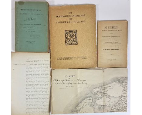
Lot 222
WATER MANAGEMENT ENGINEERING -- ZUIDERZEE, DE. Hare afsluiting en drooglegging. Benevens de rede van J.W. Telders. 1892. W. lge-fold. cold. map (loose). No bind. (Margins map a bit frayed/repaired). -- H.C. v.d. HOUVEN v. OORDT & G. VISSERING. De econ. beteekenis v.d. afsluiting en drooglegging der Zuiderzee. 1898. W. 3 fold. maps/profiles. Owrps. (Spine dam./broken, tear cut in first lvs.). -- LANDSCHAP, Het toekomstig, der Zuiderzeepolders. (1929). Prof. ill. 4°. Owrps. (Spine dam.). -- STAATS-COMMISSIE indijken Zuiderzee. 1870. Manuscript on 40 lvs. Fol. Old brds. (Spine worn). By J.H.A. Schimmelpenninck, Deventer. -- (4).

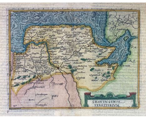
Lot 393
LOW COUNTRIES -- GRONINGEN -- "GRONINGENSE TERRITORIUM". (Cologne, c. 1587-1602). Cont. cold. engr. map of the province of Groningen by Fr. Hogenberg. 148 x 195 mm. Text on v° in Latin. Under passepartout. (Lower margin cut and professsionally repaired). NOTE:This map was first published in the early travel guide "Itinerarium orbis Christiani". It is the oldest map presenting only Groningen. It was engraved by Frans Hogenberg and the series of maps whereto it belongs, was used for several works: 'Itinerarium Belgicum' (Georg Braun, 1587), 'Belgici leonis chorographica' (Michael von Eitzing, 1587), 'De Europae virginis' (Michael von Eitzing, 1588) and in atlasses by Johannes Metellus (1598-1602). Our copy with latin text on v°, scale numbers/letters in the margin of the map, leaf 'q' on v°. - Cf. Vredenberg-Alink, p. 38 (IIA1,2, afb. 28).
Lot 1033
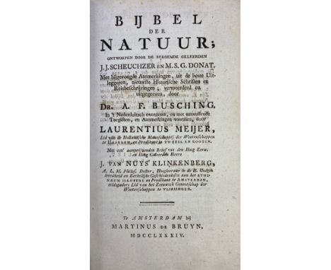
SCHEUCHZER, J.J. (& M.S.G. DONAT). Bijbel der natuur. Met bijgev. aanmerkingen, uit de beste uitleggeren, nieuwste historische schriften en reisbeschrijvingen; verm. & uitgeg. d. A.F. Busching. In 't Nederduitsch overgezet, en met aanvullende toegiften, en aanmerkingen voorzien, door L. Meijer. Amst., M. de Bruyn, 1784-92. 12 in 15 vols. W. 2 engr. fold. maps, 10 engr. plates (incl. 2 fold.). Cont. vellum. (Upper hinge vol. 5 broken, faintly stained in a few places, some minor foxing). NOTE:Very rare later Dutch edition of the 'Physica Sacra' (1731-35). With plates depicting i.a. a camel, rhinoceros, Angora goat, Jarboa mouse, a map of the Dead Sea. This work is very rare, no set sold at auction or for sale found by us. - Not in Nissen & Poortman.

Lot 1005
ANTWERP -- RECHTEN, ENDE COSTUMEN van Antwerpen. -- Bound with: ORDONNATIE ende Verhael vanden Stijl ende maniere van procederen voor Amptman Borghemeester ende Schepenen der Stadt van Antwerpen. Antw., Chr. Plantijn, 1582. 2 in 1 vol. (28), 390, (2); 56, (2) pp, blank. W. 2 woodcut city arms and 1 etched fold. map 'Beschriivinge vande paelen der vriiheiit van Antwerpen' 250 x 450 mm. Sm-fol. Cont. vellum w. overl. sides. (Last 40 pp. a bit stained, but a very good copy). NOTE:Interleaved copy, augmented by a legible early 17th c. hand, most presumably someone in/close to the city government. - Voet, Plantin Press, 569 & 108.
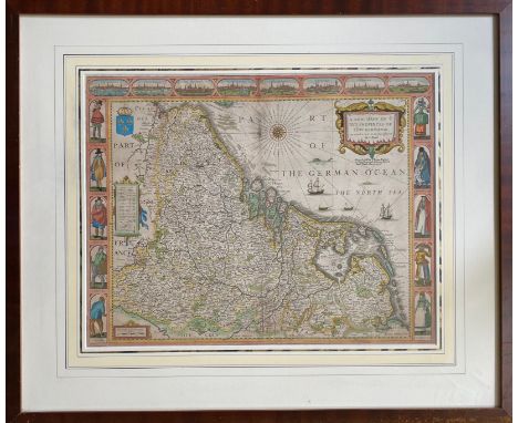
Lot 367
LOW COUNTRIES -- "A NEW MAPE OF YE XVII PROVINCES OF LOW GERMANIE, mended a new in manie places, by J. Speed". (Lond.), Th. Basset & R. Chiswell, (1676). Cold. engr. map w. i.a. a fine compass rose and ships at sea, decorated across the top with views of eight cities and panels down both sides depicting local men and women in costume dress. 417 x 535 mm. Framed, glazed and under passepartout. (Diagonal cut visible in left outer lower corner, but in very good condition, unispected out of frame. NOTE:With eight city views: Amsterdam, Antwerp, Atrecht, Ghent, Groningen, Middelburg, Utrecht and Zutphen. The sides are decorated with ten costumed figures "A Gentleman", "A Brabander", "A Hollander", "A Fisher Man" and "A Contreyman" and their female consorts. - 4th state. Van der Heijden 88.

Lot 437
POLAND -- "PALATINATUS POSNANIENSIS, in maiori Polonia primarii nova delineatio. Per G.F.M." Amst., J. Blaeu, n.d. (1659-72). Engr. map by G. Coeck, in cont. col., w. 2 coats of arms and 2 large cartouches. 417 x 528 mm. Spanish text on v°. (Small splits on vertical fold). NOTE:V.d. Krogt 1910:2.


Lot 298
TASMANIA -- STONEY, H.B. A residence in Tasmania: With a descriptive tour through the island, from Macquarie Harbour to Circular Head. Lond., Smith, Elder, & Co., 1856. viii, 311, (1) pp. W. fold. map of Tasmania & 8 tinted lithogr. plates (incl. front.) & sev. text-ills. Beautiful cont. full red cf. w. richly dec. gilt back, blue label, sides ruled in gilt, & fine marbled edges. NOTE:Copy with handwritten dedication by a schoolfellow to William Stephen Gore Langton (1847-1902), 4th Earl Temple of Stowe, on his leaving Eton in 1864. - Fine and attractive copy.


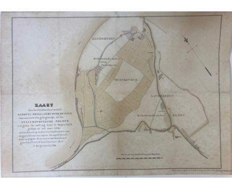
Lot 388
LOW COUNTRIES -- GELDERLAND -- "KAART der buitenlanden van het kerspel Driel (…) voor zoo verre die gelegen zijn in de Meijerwijcksche Polder volgens de meting door W. Beijerinck, gedaan in het jaar 1776. Geteekend (…) door mij (…) geadmitteerd Landmeter, (…) F. Beijerinck, 1796". Tinted manuscript map of the 'Landereijen Meijerswijck & Elden', augmented in 1806. 490 x 680 mm. (Laid down, some minor damage to surface, but in good condition). NOTE:NNBW II, p. 333: "Frederik Beijerinck (2), geb. te Nijmegen 20 Juli 1766, overl. te Arnhem 25 Aug. 1838, was de zoon van den landmeter van het ‘Furstendom Gelre en graafschap Zutphen’ M. Beijerinck en werd in hetzelfde vak opgeleid. Het is onbekend, wanneer hij in dienst trad, maar hij was nog in het begin van 1811 landmeter te Nijmegen."
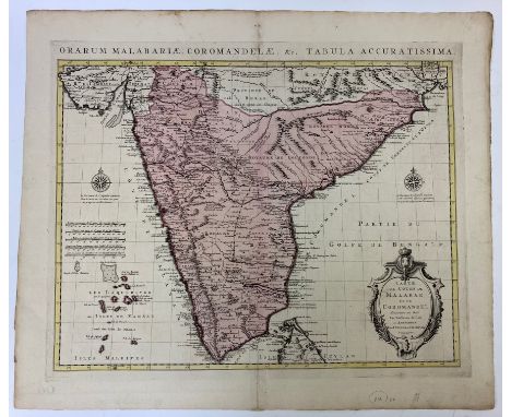
Lot 361
INDIA -- "CARTE DES CÔTES DE MALABAR ET COROMANDEL (…)". Amst., Covens & Mortier, (c. 1730). Engr. map of the southern part of India w. large cartouche and compass rose in cont. col. 478 x 590 mm. (Upper blank margin a bit browned, but in fine condition). -- Added: "NIEUWE KAART van t Keyzer Ryk van den Grooten Mogol". Amst., I. Tirion, (c. 1770). Engr. map of India in cont. col. 298 x 371 mm. -- (2).

Lot 994
IBERIAN PENINSULA -- (VERTOT, R.A. De). Histoire de la conjuration de Portugal en 1640. Amst., H. Desbordes, 1689. 147, (2) pp. 12°. Cont. cf. w. raised bands & mor. letterpiece. -- Id. Histoire des révolutions de Portugal. Amst., É. Roger, 1722. 165, (14) pp. W. engr. front., large fold. map of the peninsula, large fold. geneal. tree & a fine profile view of Lisbon seen from the sea. Cont. cf. w. raised bands & dec. gilt back. (Joints split, spine ends chipped, mor. letterpiece lacks, small tears in plates. -- And 1 other by Marie Catherine d'Aulnoy (Memoires de la cour d'Espagne. 2e éd., The Hague, A. Moetjens, 1691. 2 parts in 1 vol.) (3). NOTE:Ad 1: Fine copy of the first publication of the historian and political writer René Aubert, sieur de Vertot (1655-1735), published in the same year as the original edition (Paris, J. Boudot). After 1711 the work was published with the title "Histoire des révolutions de Portugal". - From the library of John Marques of Tueeddale, Earle of Grifford, with his engr. heraldic bookplate on upper pastedown.
Lot 958
KENNEMERLAND -- BROUËRIUS v. NIDEK, M. Het zegenpralend Kennemerland, vertoont in 100 heerlyke gezichten van de voornaamste lustplaetzen, adelyke huizen, dorp- en stede-gebouwen; Beginnende met Kastrikum, vervolgende door 't Quartier van Heemskerk, Beverwyk, Velzen, Bloemendael, Overveen, de Vogelezang, Zantvoort, Haerlem, en eindigende met het Quartier van Heemstede, Berkenrode en Bennebroek. Amst., A. & H. de Leth, (c. 1730). 2 parts in 1 vol. (6), 24; 18 pp. W. 2 identical engr. fronts., 1 engr. ti-vign. & 1 engr. headpiece, 100 views on 50 plates by H. de Leth. Fol. Old (worn) limp brds. (Map is lacking, some plates loose, a bit stained/soiled in places, margins cut). NOTE:One of the finest books on 18th-cent. Dutch country houses, public buildings, parks, gardens, including garden layouts, in Kennemerland. - Tiele, 51 note. - Sold w.a.f., not subject to return.

Lot 351
CELESTIAL CHART -- "STERRE KAERT of Hemels Pleyn, waerdoor men kan wete hoe laet dat het is over de gehele Aertkloot, (…)". Amst., J.B. Elwe/J. de Ram, (c. 1792). Engr. representation w. i.a. the signs of the Zodiac. 542 x 642 mm. NOTE:Star chart on which all constellations are drawn. The map is divided in width in 12 months from October. The bottom 1/3 has the same division into twelve with the corresponding constellations and their important data: hours, signs, degrees. Bottom right the 'lost constellation' of the 'Noah's Ark'. The tables containing the data are coloured.

-
109182 item(s)/page