We found 108737 price guide item(s) matching your search
There are 108737 lots that match your search criteria. Subscribe now to get instant access to the full price guide service.
Click here to subscribe- List
- Grid
-
108737 item(s)/page


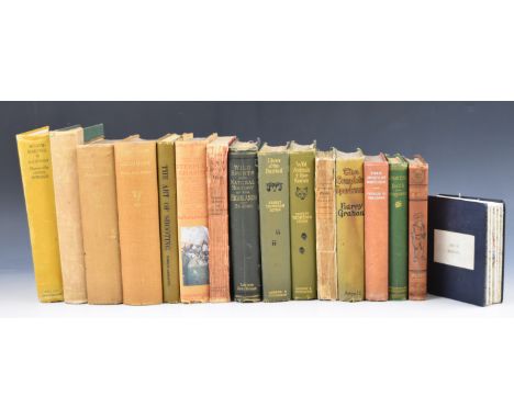
Lot 98
The Shooter’s Guide or Complete Sportsman’s Companion by B. Thomas 1826 with engraved plates. An Illustrated Treatise on The Art of Shooting by Charles Lancaster 1889 illustrated. Shots from A Lawyer’s Gun 1927. Mr. Punch with Rod and Gun. Sporting Days by John Colquhoun 1866. Sketches of the Wild Sports & Natural History of The Highlands by Charles St. John illustrated 1878. Field Sports of Scotland 1936. The Complete Sportsman 1914 illustrated Lewis Baumer. Sportsman’s Bedside Book by B.B. 1937. Moonraking illustrated Lionel Edwards 1936. Lives of the Hunted and Wild Animals I Have Known by Ernest Seton. Mountaineering with 130 illustrations, Hounds & Dogs Their Care, Training & Working illustrated 1932 and Steeplechasing (Lonsdale Library). Linen backed map of Gloucestershire / Wiltshire labelled 'Duke of Beaufort' (16)


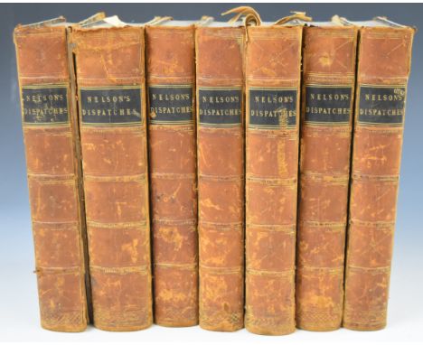
Lot 114
The Despatches & Letters of Vice Admiral Lord Viscount Nelson with Notes by Sir Nicholas Harris Nicolas, published Henry Colburn 1844-1846 in 7 volumes with several folding plates, portrait, map, facsimile handwriting, etc bound in half leather with gilt lettered leather labels (one boards detached)

Lot 123
The ‘Maiwand survivor’ Abyssinia and Afghanistan pair awarded to Major-General C. M. Griffith, 1st Bombay Grenadiers, who took over command of his Regiment after Colonel Anderson was severely wounded; when the inexperienced Jacob’s Rifles broke and fled, Griffith was ‘Conspicuous in his Efforts to Steady his Men’ and motivate the Bombay Grenadiers to ‘Fight On’, saving his Regiment’s reputation and averting a total disaster; afterwards he reconstituted a fighting unit from the surviving Grenadiers and commanded it during the Defence of Kandahar City and the subsequent victory at the Battle of Kandahar Abyssinia 1867 (Captn. C. M. Griffith. Bombay Staff Corps); Afghanistan 1878-80, 1 clasp, Kandahar (Lieut. Col. C. M. Griffith. Bo. N.I.) both fitted with contemporary silver riband buckles, nearly extremely fine (2) £4,000-£5,000 --- Charles Matthew Griffith was born at Poona on 19 October 1834, the son of Colonel Julius George Griffith, later General and Colonel Commandant, Bombay Artillery. He was educated at Cheltenham College, nominated as an HEIC Cadet, and passed the Military Committee at East India House on 4 February 1852. After being twice rejected for his weak English and Latin, he was admitted to Addiscombe on 6 August 1852, and commissioned Ensign in the Bombay Infantry on 8 June 1854, at the age of 19. He arrived in Bombay on 23 September 1854 for regimental service with the 1st Bombay Native Infantry (Grenadiers). From June 1859 he was variously employed with the Irregular Cavalry, the Sind Judicial and Police departments, and as Superintendent of Police for the Great Indian Peninsular Railway. The March to Fortress Magdala By 1868, Griffith was a Captain in the Bombay Staff Corps. He was first sent on active service during the Abyssinia Campaign, the most logistically challenging but among the best executed of the British expeditionary wars up to that time. He was given responsibility for organising and commanding ‘A’ Division Highland Transport Train, 1st Brigade of the 1st Division, Abyssinian Field Force. He also commanded the stretcher-bearers who recovered the wounded on 10 and 13 April 1868 from the battlefields of Arogee and Magdala. He was created Brevet Major on 15 August 1868 and was four times Mentioned in Despatches: London Gazette 16 June 1868: ‘The bandsmen and a party of Punjab muleteers were also organised under command of Captain Griffith and furnished with stretchers for the removal of wounded men from the field.’ London Gazette 30 June 1868: ‘Captain Griffith [and other officers] have distinguished themselves by their zeal and activity and deserve special notice.’ London Gazette 10 July 1868: ‘Captain Griffith [and other officers], Land Transport Corps, commanded the first Divisions that were raised, are strongly recommended by the Director of Transport Corps for the extent and value of their assistance.’ London Gazette 7 August 1868: ‘The working of the Train next comes into consideration, which commenced with the arrival of Captain Griffith, with the advance Brigade... The Train was divided into four divisions... and Captain Griffith commenced the formation of “A” Mules... Difficulties and disasters met these officers at every step. Mules landed without equipment in hundreds, and with muleteers of the class already spoken of. At that time these officers having no subordinates had to look to everything themselves... The pleasing task now remains of bringing to the special notice of His Excellency the names of such officers more especially deserving of his kind consideration, and whose efforts came under the personal observation of the Director, who from first to last, never failed... Captain C. M. Griffith, Bombay Staff Corps.’ Griffith was granted furlough to England from 10 October 1868 to 22 November 1870. After marrying and returning to India, he was appointed Brigade Major, Aden in November 1871, promoted Major in June 1874, and Lieutenant-Colonel in July 1877. In August 1879, at the age of 44, he was appointed officiating Second in Command of 1st Bombay Grenadiers, considered to be an elite Indian regiment smartly turned out in a uniform of red jacket, khaki turban and dark blue trousers with white gaiters. Griffith accompanied his regiment to join the South Afghanistan Field Force via the Bolan and Khojak Passes in October 1879, experiencing the hostile, anti-British environment of the Kandahar region for many months. In July 1880 a column built around Brigadier Burrows’s 1st Brigade, which included the Bombay Grenadiers, was sent west to Girishk on the Helmand river. At the disastrous battle of Maiwand on 27 July 1880, Griffith initially commanded the Grenadier’s Right Wing, and then took command of the whole Regiment at around 3pm, after Colonel Anderson was severely wounded and evacuated. Maiwand Two months later, in mid-September 1880, the British, including some officers who had survived the massacre, revisited the battlefield. They found that the European and Indian bodies had been left to disintegrate where they fell, but, learning of the British return, local Afghan villagers had hastily buried them just days before in 40 separate shallow graves at the places where they had died. The battlefield was carefully surveyed and the graves plotted on the battle map, then opened and their contents recorded. The correlation of the battlefield survey with the unsatisfactory and evasive official despatches of the force commanders was so contradictory that each surviving officer was ordered to submit a written report outlining what he had directly witnessed. Lieutenant-Colonel Griffith’s official account is quoted below, slightly abridged, while extracts of accounts given by other officers mentioning Griffith are inserted in italics. ‘On the 26th July 1880, the force under Brigadier-General Burrows [personally brave but indecisive, cautious and totally inexperienced in commanding an all-arms force], which consisted of the following troops [2,600 men], were encamped at Khushk-i-Nakhud, which is on the road from Kandahar to Girishk on the Helmand and distant from the former place about fifty miles: E-B, Royal Horse Artillery [146 men]; Detachment [260 men], 3rd Sind Horse; Detachment [315 men] 3rd Light Cavalry; Detachment [46 men] Bombay Sappers and Miners; 66th Foot [473 men]; 1st Bombay Grenadiers [649 men, the largest infantry unit in the force]; and Jacob's Rifles [624 men]. It was generally believed… that an Afghan force, consisting of about 20,000 men and 36 guns, under Ayub Khan, was not far distant; but such was the enmity against us, that neither the political officers nor our own cavalry patrols were able to obtain reliable information either as to the correct numbers or the exact position of the Afghan force. However, information was received that a few ghazis and some cavalry of Ayub Khan’s advanced guard had occupied the village of Maiwand… and during the night orders were issued for our brigade to march on Maiwand the next morning [27 July] at 6:30 a.m. The position occupied by Ayub Khan’s army at this time was unknown. Owing to the large quantity of ordnance and commissariat stores which had been stowed away within walled enclosures at Khushk-i-Nakhud, and the loading of which took a considerable time, the force did not start punctually, and the sun was well up, and the heat considerable, before we were all off the ground. The force advanced with cavalry and two guns of E-B, Royal Horse Artillery, in advance; the infantry in line of columns at deploying distance; baggage on the right flank; and the whole brought up by a rear-guard of two guns and some cavalry, each regiment of infantry ...

Lot 61
A good Second War ‘Burma operations’ M.C. group of five awarded to Jemadar Sultan Ali, 4th (Sikh) Battalion, 12th Frontier Force Regiment, Indian Army, for his gallantry in leading an attack on a heavily enemy occupied village on 25 March 1945 Pakistan Independence Medal 1947 (PJO 16092 Jem Sultan Ali 12 F.F.R.); Military Cross, G.VI.R. reverse officially dated 1946; 1939-45 Star; Burma Star; War Medal 1939-45, mounted court-style as worn in this order, very fine (5) £1,000-£1,400 --- M.C. London Gazette 2 August 1945: ‘In recognition of gallant and distinguished services in Burma.’ The original Recommendation, for an Immediate award, states: ‘On 25 March 1945 Subedar Sultan Ali was the commander of No. 7 Platoon, C Company, ordered to attack and clear the village of Kyigon (Map Meiktila sheet 1:25000, Square 3134). The company went in with No 7 Platoon as a spear head, as the degree of enemy resistance was at this time was not known, and had to be ascertained. A troop of tanks was in support, but took no part in the first phase of the attack, and remained behind, outside the village. On entering the village Subedar Sultan Ali’s platoon soon came under fire from Japs in the trenches and fox-holes in the vicinity of the Pagodas to their front. By skilful manoeuvring of his sections Subedar Sultan Ali soon overcame this opposition, about one section strong, and destroyed the enemy. He them continued his advance into the village, and came under automatic fire from strong bunker to his front, and heavy sniping from both flanks. The platoon was pinned down, and almost at once the enemy begun to shell the position from close range, with great accuracy, and casualties to the platoon begun to mount. A lesser man might have withdrawn his platoon from such a predicament, and gone in again with tank support, but Subedar Sultan Ali at once decided that the solution lay in a swift and determined attack to destroy the enemy and occupy his trenches. This he did, and under his inspiring leadership his platoon went in and at the point of bayonet, destroyed the enemy, and occupied his position. Subedar Sultan Ali was badly wounded by a shell splinter in the stomach before reaching the enemy position, but continued to direct his platoon and shout encouragement, until the enemy were destroyed and the men under cover. Not till then did he allow himself to be dragged away and evacuated. The platoon suffered 2 killed and 9 wounded in the action, but secured a firm base in the centre of the enemy resistance, and it was from here that the further operations of the Company were launched, with the tank support, and the village completely cleared, in spite of constant shelling. Kyigon was not again occupied after our men were withdrawn in the evening. This Subedar has shown determination and skilled leadership of the highest order, and his courage has inspired his men to give of their utmost throughout the recent operations.’ Sultan Ali was born in the district of Rawalpindi and attested for the 12th Frontier Force Regiment, Indian Army, on 21 June 1930. He served with them during the Second World War in Burma from 9 December 1941 to 20 May 1942; in Assam from May to August 1942; ands again in Burma from 5 February 1945. He was pensioned on 21 June 1958, after 28 years’ service. Sold with copied service records and a photographic image of the recipient.

Lot 455
British South Africa Company Medal 1890-97, reverse Matabeleland 1893, 1 clasp, Rhodesia 1896 (Trooper S. G. Greer Victoria Column.) nearly extremely fine and a rare casualty £1,000-£1,400 --- Roll confirms 1893 Medal, Trooper, Victoria Column; 1896 Clasp, Trooper, “C” Troop, Bulawayo Field Force. Stuart George Greer was killed in the rearguard action on the Tuli Road on 10 April 1896, when on the Gwanda Patrol, near Fort Umlugulu. ‘On Thursday, April 2nd, a force consisting of 50 mounted men Bulawayo Field Force, 50 of the Afrikander Corps mounted under Capt. Van Niekerk, one Maxim gun and detachment, and Dr. Levy with ambulance, left Bulawayo at 5 p.m. -the whole under command of Capt. Brand, to proceed to Manzi-Izama in Gwanda district. His orders were to bring into Bulawayo the white population of Manzi-Izama, if still there. They had been warned to leave eight days previously, but had stated they wished to remain where they were. Matters, however, becoming so critical, and their force so small, a relief party was deemed necessary. No opposition was met with on the march down, and the people were found to have retired on Tali. Capt. Brand had been instructed to report on the road, particularly with reference to suitable sites for fortified camps, water supply, &c., with a view to future operations by a detached force. Manzi-Izama is 80 miles distant; the road is practically a defile, commanded on either hand from Spargo's store, 12 miles from this town, to Manzi-Izama. On the return march, opposition was first met with seven miles this side of Spiro's store, the force being fired on from kopjes commanding the advance. The flanking parties became at once engaged, pushing the rebels before them, and occupying flanking positions as they advanced. On reaching the point almost parallel with Latijan's farm, between the two hills shown on may, the dissel boom of the wagon broke. Firing recommenced and continued till more open ground was reached. The Matabele then appeared in considerable force, and Capt. Brand determined to take up a position on the left of the road on a hillock with about 50 feet command. The Maxim was placed on the salient commanding the road to the east, the Afrikanders on the right, and the remainder under Lieut. Pursell on the left. Fair cover was obtained for the horses; the scrub came pretty well up to the position on the south and east faces. A determined attack then developed on three sides of the position, the rebels being. in possession of a large number of guns of sorts, and running up with great determination, some reaching to within 30 yards of the firing line. The Maxim opened early, and did good execution, but the thickness of the bush prevented full use being made of the longer ranges. The attack was successfully repulsed on the south and east faces, largely due to the action of the Maxim, whose fire was then turned on the north attack, which was making considerable headway, but which immediately slackened. Capt. Van Niekerk then mounted 25 of his men, who made a counter attack on the thick bush into which the rebels had retired, their right being safeguarded by the fire of the guns. The rebels were pushed through the bush on to open ground beyond, where the Afrikanders inflicted heavy loss on them. By this time the remainder of the force was mounted and proceeded, as shown on map, to avoid the kopje and thick bush commanding the road, which was struck 300 yards further on, the Afrikanders forming the rearguard. Casualties: five killed, 15 wounded, 30 horses lost. The dead had to be left.’ Trooper Stuart George Greer was buried in one grave with Trooper Christopher John Packe, also of “C” Troop, in the small cemetery at Umlugulu. Sold with copied research from National Archives of Zimbabwe including letters from his mother and brother, death notice, and account of the action.

Lot 351
PIETER VAN DEN KEERE coloured antiquarian map entitled in cartouche 'Wales', showing the whole of Wales and a small section of Ireland, with inset scale of miles, compass and other illustrations, circa 1620s, 8 x 12cmsProvenance: the Welsh art collection of award-winning television producer, the late Pat Llewellyn (1962-2017), by descentComments: framed and glazed, ready to hang

Lot 350
JOHN CARY / C & H GREENWOOD / GREENWOOD coloured antiquarian maps - entitled (1) 'Principalities of Wales', dated 1809, by John Cary, 48 x 57cms (2) Greenwood & Co coloured antiquarian map of Hereford, 65 x 78cms (3) C & H Greenwood 'Monmouth', 64 x 79cms together with C&J GREENWOOD coloured antiquarian map of the South East Circuit of the Principality of Wales, comprising of the counties of Glamorgan, Brecon & Radnor, 63 x 70cms (4)Provenance: private collection PowysComments: John Cary and C&J Greenwood maps framed, the other two Monmouth and Hereford maps unframed
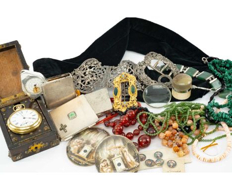
Lot 28
ASSORTED JEWELLERY & COLLECTABLES including various beads including malachite, green hardstone bracelet, Ingersoll pocket watch in folding stand, 2 x white metal compacts (one set with jadeite and marcasite ornament), silver folding map odometer, silver pierced heart shaped buckle, yellow metal gem set buckle, magnifying glass, silver pierced cherub and floral belt buckle etc.Provenance: private collection CarmarthenshireComments: the portrait miniatures and oval plaques illustrated with the lot are not included int he sale. Odometer not working.
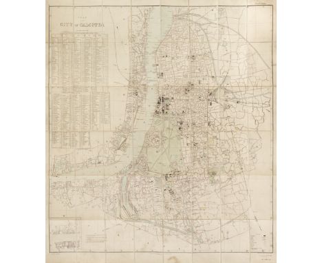
Lot 83
Calcutta. Plan of the City of Calcutta, published under the direction of Colonel St. G. C. Gore, R. E. Surveyor General of India, Calcutta: May 1901, large colour lithographic map, sectionalised and laid on linen, inset lists of streets and lanes, slight staining to the margins, 1240 x 1025 mm, marbled endpapers which are frayed, contained in a near contemporary green cloth slipcase, the slipcase worn and frayed, together with Allen (W. H. & Co. publishers). Map of India from the most recent Authorities, 1859, map engraved by J & C Walker with contemporary wash colouring, sectionalised and laid on linen, table of explanation, slight staining, 930 x 830 mm, advertisement endpapersQTY: (2)
Lot 235
Camden (William). Britannia siue Florentissimorum Regnorum, Angliæ, Scotiæ, Hiberniæ et Insularum adiacentium ex intima antiquiate Chorographica dsescriptio, Authore Guilielmo Camdeno, Nunc postremo recognita, & magna accessione post Germanicam aeditionem adaucta, 5th edition and 1st with maps, London: George Bishop, 1600, additional engraved title by William Rogers (repaired closed tear to lower left of image plus minor paper residue in the same area) letterpress title with large woodcut royal coat-of-arms bound in after dedication, additional title page for Hiberniæ et Insularum Briitanniæ Adiacentium descriptio..., 3 engraved maps by William Rogers; Britannia Provincia Romanorum, Englalond Anglia Anglosaxonum Heptarchia and Hibernia Antiqua (the latter printed to recto of Bbb8), full-page engraving of Stonehenge to P6, several full-page engraved illustrations of coins and antiquities, woodcut head-pieces, decorative initials, etc., contemporary ink marginal annotations to a few leaves including index and additional title page for Hiberniæ et Insularum, some water staining to margins, wormhole to top inner margin from first additional title to D1, tear with loss to outer top margin to Q3, later endpapers, contemporary blind stamped calf rebacked, lacking title label, boards rubbed, spine and corners worn & showing, upper board detached, small 4to QTY: (1)NOTE:STC 4507; Shirley 230.Bonar-Law pre-1612 P235 (for Hibernia Antiqua).Includes Rogers's map of Ireland copied from the 1595 Mercator map but showing Ireland in ancient times.

Lot 115
Shropshire. Speed (John), Shropshyre described. The Sittuation of Shrowesbury shewed with the Armes of those Earles and other memorable things observed, George Humble, circa 1627, hand-coloured engraved map, an inset town plan of Shrewsbury, large strapwork cartouche and mileage scale, slight creasing and spotting, several repaired marginal closed tears, central fold partially strengthened on verso, 385 x 515 mm, English text on verso, together with Schenk (Petrus & Valk Gerard). Comitatis Cantabrigiensis vernacule Cambridgeshire, Amsterdam, circa 1700, engraved reticulated map with contemporary wash colouring, decorative cartouche and mileage scale, large margins, central fold strengthened on verso, 405 x 510 mm, with Ruscelli (G.). Tabula Europae III, Venice, circa 1599, hand-coloured engraved map of France, 135 x 175 mm, Latin text on verso, plus, Bertius (Petrus & Langenes Barent). France, circa 1602, hand-coloured engraved map, slight overall toning, 90 x 125 mm, French text on verso, and Van den Keere (Pieter). Bolonia, circa 1630, hand-coloured engraved map, 130 x 165 mm, Latin text on verso, with an uncoloured engraved strip road map by Owen and Bowen, running through Buckinghamshire, Northampton, Warwickshire and Oxfordshire, printed on both sides, 200 x 120 mmQTY: (6)

Lot 117
Surrey. Greenwood (C & J), A Map of the County of Surrey from an actual survey made in the years 1822 and 1823, George Pringle Jnr. 1st September 1823, large scale engraved map with contemporary hand colouring, sectionalised and laid on linen, uncoloured vignette of Kew Palace, compass rose, table of explanation, calligraphic cartouche and dedication, the whole edged in blue silk (some loss), minor offsetting, faint pencil markings to lower right, blind scratches to scale, 1000 x 1200 mm, contained within contemporary marbled calf book box (rubbed and slightly worn)QTY: (1)

Lot 52
Sopwith (T). An Account of the Mining Districts of Alston Moor, Weardale, and Teesdale, in Cumberland and Durham; comprising Descriptive Sketches of the Scenery, Antiquities, Geology, and Mining Operations, in the Upper Dales of the Rivers Tyne, Wear, and Tees, Alnwick: Printed by and for W. Davison, 1833, hand-coloured engraved map frontispiece (lightly offset to title), scattered spotting, three previous handwritten ownership inscriptions and one later ink stamp to front pastedown and endpaper, ownership stamp in blue ink to verso of map, original green cloth, printed label to spine, 8vo, together withDana (James). Manual of Mineralogy, including observations on mines, rocks, reduction of ores..., 4th edition, New Haven: Durrie & Peck, 1851, numerous illustrations throughout, some spotting, previous ownership inscription to front pastedown, hinges reinforced with archival tape to front pastedown and front fly leaf, original speckled calf, toned and rubbed with some loss, lower board partially detached, gilt spine, cracked and rubbed with some loss at head and tail of spine, 8voQTY: (2)

Lot 97
Ireland. Camocio (Giovanni Francesco), Irlanda, published by Fernando Bertelli, Venice, circa 1575, uncoloured engraved map oriented to the east, large margins, slight spotting, 135 x 190 mmQTY: (1)NOTE:Andrew & Charlotte Bonar Law. The Printed Maps of Ireland to 1612, page 11.Rare. Camocio is believed to have died in Venice in the early 1570s, probably during an outbreak of the plague. His plates passed to Bertelli who re-issued Camocio's Isole Famosa Porti Fortezzi..., about 1575. The maps are unchanged apart from the addition of a page number to the lower right corner of the map.

Lot 219
* Gillray (James). Phaeton alarm'd! H. Humphrey March 22nd 1808, etching with contemporary hand-colouring, large margins, borders a little toned and dust soiled, some marginal closed tears, later ink marginalia and some ink linear marks affecting the printed image, 340 x 375 mmQTY: (1)NOTE:BM satires 10972.A somewhat sycophantic caricature by Gillray depicts Canning as Phaeton driving a chariot across the sky in a semi-heroic composition. Gillray is gentle with the Foreign Secretary depicting him travelling across a celestial panorama, filled with malevolent opponents. Below the panorama is a map of Europe set ablaze by the Napoleonic wars.
Lot 268
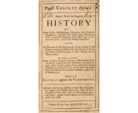
Popery. Popish Cruelty Display'd, Being a short, but impartial history of some of the assassinations, murders, and inhumane slaughters, committed by papists upon protestants ..., [London?], 1718, guarded-in title edge-frayed and with early ink manuscript name Willm Hodgson, bound with: Nottingham (Daniel Finch, Earl of), The Answer of the Earl of Nottingham to Mr. Whiston's Letter to Him, concerning the Eternity of the Son of God, and of the Holy Ghost ..., eighth edition, London: for Edward Valentine, 1721, 3pp. advertisements at end, bound with: [Randolph, Herbert], Some Plain and Short Arguments from Scripture proving the Lord Jesus Christ to be the supreme God ..., sixth edition, London: for John Clark, 1719, bound with: Popping (S., publisher), The Lay-Mens Humble Representation of their Just Grievances, London, 1720, bound with: Calamy (Edmund), A Letter to Mr. Archdeacon Echard, upon occasion of his History of England, third edition, London: for John Clark, 1718, woodcut head- and tail-pieces and initials, generally toned, occasional minor marks or stains, some dust-soiling, hinges cracked, mid-18th century blind-tooled calf, rubbed, one corner showing, minor worming to spine ends, 8vo, together with: [Zacharie de Lisieux, pe?re], A Rela[tion] of [the] Cou[ntry of] Ja[nsenia, Ne[ver Till Now Described, Wherein] is [... composed in French by Lewis Fountaine, Esq; and newly translated into English by P.B.], [1668], majority of title lacking and torn away (with an additional usual version of the title bound-in at the rear), without folding map, some toning, dust- and finger-soiling mainly at front and rear, few leaves lightly edge-frayed or with minor losses to blank margins, without front endpapers, contemporary calf, worn, small 8vo, plus: Gunter (W.), Gunter's Confectioner's Oracle, London: Alfred Miller, 1830, 4 plans (one folding), without portrait frontispiece, lightly toned, scarce minor spotting, hinges cracked, contemporary maroon half calf, worn, front joint cracked and board loose, spine covering defective, 8vo, with 4 other antiquarian titles (one in 2 volumes), some defectiveQTY: (8)NOTE:First item: ESTC T180090, T21975, T49335, T171246 & T38157 respectively.Second item: ESTC R38878; Wing F1410 for the usual edition. This copy appears to have remnants of a rare version of the title with the additional phrase 'Never till now described'. This version is not in ESTC, Wing or Library Hub. We have only found one mention of this version: in the catalogue of the first portion of the ... library of the late James Crossley, sold by auction by Sotheby, Wilkinson & Hodge 21-28 July 1884 (lot 896).
Lot 100
Ireland. Philippe (Pierre), L'Irlande conforme aux Itinéraires et assujettie aux observations astronomiques..., circa 1787, uncoloured engraved map, three lines of scale to the right-hand vertical margin, 270 x 405 mm, together with Van der Aa (Pieter). Lagenie où Leinster, Leiden, circa 1710, hand-coloured engraved map presented in a 'picture frame' border, 235 x 400 mm, with Seale (R. W.). Plans of the Principal Towns, Forts and Harbours in Ireland; For Mr Tindal's Continuation of Mr Rapin's History, circa 1760, sixteen uncoloured engraved plans on one sheet (as published), old folds, 405 x 500 mm, plus Turrel (E.). Dublin [and] the Environs of Dublin, published under the Superintendance (sic) of the Society for the Diffusion of Useful Knowledge, 1833, two engraved city plans, both with contemporary outline colouring, slight mount staining to the plan of Dublin, each approximately 320 x 400 mm, with another copy similar of the plan of Dublin, and Walker (J & C). Ireland, published under the Superintendence of the Society for the Diffusion of Useful Knowledge, circa 1833, engraved map with contemporary outline colouring, 390 x 330 mm, with Chatelain (Henri). Carte du Gouvernement Civil et Militaire avec L'Etat des Officiers du Royaume D'Irlande, circa 1719, two uncoloured engraved maps of Ireland, two heraldic shields and two interior views of the Irish parliament, all set within descriptive French text, 365 x 465 mm QTY: (8)NOTE:Andrew Bonar Law. The Printed Maps of Ireland 1612 - 1850, number 134 ii (Philippe).
Lot 407
Malcolm (John). The Political History of India from 1784 to 1823, 2 volumes, 1st edition, London: John Murray, 1826, errata leaf at end of vol. I, light spotting front and rear, irst volume with ownership signature John Stracey 1827 to pastedown, edges untrimmed, original cloth-backed boards, printed paper title label to spines of each volume, spines and joints worn, 8vo, together with: Barrow (George). Ceylon: Past and Present, London: John Murray, 1857, folding engraved map, 32 pp. publisher's adverts at rear, original cloth gilt, extremities lightly rubbed, 8vo, plus Radclyffe (Charles W.). Memorials of Eton College, 1st edition, Eton: T. Ingalton & Son, 1844, tinted lithograph title and 23 plates, foxing and some damp staining, contemporary red half morocco, gilt decorated spine, some wear and marks, folio, plus Peel (Lawrence). Horæ Nauseæ, London: Printed by Bradbury and Evans, 1841, contemporary manuscript note to verso of front free endpaper; 'Edwards Anson, From the Author, Laurence Peel, Jun 12, 1879(?)', light spotting, publisher's original cloth binding, 4to, plus 14 other volumes and 3 folding maps (Switzerland, India, The North of England and part of Scotland), various sizes and condition QTY: (22)
Lot 5
Bower (Hamilton). Diary of a Journey Across Tibet, 1st edition, London: Rivington, Percival and Co, 1894, ownership inscription of John Bower (the author's brother) to half-title, frontispiece, folding map (frayed with small loss), 29 full-page and smaller illustrations, hinges cracked, sewing loosened with text block separated in places, original green pictorial cloth, rubbed with some wear to extremities, 8voQTY: (1)NOTE:Yakushi B533. In 1891 Hamilton Bower and Dr. W. G. Thorold, at the instigation of the British Indian intelligence service, travelled 1200 miles across the Tibetan plateau through unknown country, at an average elevation of 19000 feet, despite being deserted by their guides, their food supplies giving out and almost all their transport animals dying. The Indian sub-surveyor Atma Ram accompanied Bower and Thorold and made an important map of the region which is reproduced in the book. Bower was the first European to cross the Tibetan plateau, for which he was awarded the Founder's Medal of the Royal Geographical Society.


Lot 121
Wales. Speed (John), Cardigan Shyre Described with the due forme of the Shire town as it was surveyed by J. S. in 1610, Thomas Bassett & Richard Chiswell [1676], engraved map with sparse outline colouring, inset town plan of Cardigan, large strapwork cartouche and compass rose, some marginal fraying and chipping but not affecting the printed image, 380 x 510 mm, English text on verso, together with Speed (John). Caermarden Both Shyre and Towne Described, John Sudbury and George Humble, circa 1627, uncoloured engraved map, inset town plan of Carmarthen, large strapwork cartouche and compass rose, toned overall, 385 x 510 mm, no text on verso, with Blaeu (Johannes). Glamorganensis Comitatus vulgo Glamorgan Shire, Amsterdam, circa 1648, engraved map with contemporary outline colouring, some creasing to the central fold, slight staining, large margins, 380 x 505 mm, French text on verso, with another three Welsh county and regional maps including examples by or after Moll, Mercator and Speed, various sizes and conditionQTY: (6)

Lot 418
Du Chaillu (Paul B.). Explorations and Adventures in Equatorial Africa;..., 1st edition, New York: Harper & Brothers, 1861, numerous monochrome illustrations, folding map to the rear, some light spotting & marginal toning, original embossed brown cloth, boards & spine rubbed & slightly water marked, 8vo, together with:Brown (J. Tom), Among the Bantu Nomads, 1st edition, London: Seeley, Service & Co., 1926, 17 monochrome illustrations, some light marginal toning, original cloth in dust jacket, covers rubbed with some loss, 8vo, plusWeeks (John H.), Congo Life and Folklore, London: The Religious Tract Society, 1911, monochrome illustrations, frontispiece detached, some spotting &light toning, original decorated green cloth, spine lightly rubbed to head & foot, 8vo, and other late 19th & early 20th century Africa reference & related, including The Colonial Office List, 3 volumes 1908, 1912, 1933, London: Waterlow & Sons, original red cloth, 8vo, & 7 folding maps, mostly original cloth, some paperback editions, some odd volumes, G, 8voQTY: (3 shelves)

Lot 45
Park (John James). The Topography and Natural History of Hampstead, in the County of Middlesex, 1st edition, London: White, Cochrane, and Co, 1814, engraved frontispiece, folding map, 9 engraved plates (one loose), lightly spotted, contemporary calf rebacked to style, green morocco title label lettered in gilt, blindstamped armorial of William Bagot, 2nd Baron Bagot to covers, some light wear, 8voQTY: (1)NOTE:Provenance: William Bagot, 2nd Baron Bagot, included in list of subscribers.
![Bible [English]. The Holy Bible, conteining the Old Testament and the New. Newly Translated out of the Originall Tongues: and](https://cdn.globalauctionplatform.com/2c61f7bf-ae43-41de-bb88-b132012566a4/511add05-8559-4643-8a5a-b13e010bf453/468x382.jpg)
Lot 237
Bible [English]. The Holy Bible, conteining the Old Testament and the New. Newly Translated out of the Originall Tongues: and with the former Translations diligently compared and revised, by his Maiesties special commandement. Appointed to be read in Churches, Imprinted at London by Robert Barker, 1613, general title within decorative woodcut border with genealogical entry to verso 'John Willis being born in the year 1705. Ye daughter of John Willies was borne febry. ye 5 1719/20' (short closed tear at head), New Testament title within decorative woodcut border with imprint dated 1612 (with small torn area towards gutter and slight border loss, manuscript alphabet, numbers and marks to verso), Apocrypha present, A4 of Translations to the Reader torn with text loss to lower outer quarter of leaf, D43 with upper outer corner torn away, closed tear to 2G1 and 2G2 at head, 2K4 with early manuscript inscriptions to verso and bearing the names Robert Hickson[?], John Douthwaite and George Harrison, 2P3 torn to lower outer corner with test loss, 2T2 closed tears at foot, 2V6 torn at foot with slight text loss, 3D3 torn to lower outer corner with loss, 3K7 with repaired long closed tear, 3T5 and 3T6 with small torn area and loss towards gutter, 3Z5 torn at foot with text loss, [A3] torn to upper outer corner with loss, [L7] with old paper repair at foot, manuscript inscriptions and notes to verso of final leaf of text, colophon dated 1612, few other short closed tears (few repaired), bound with at front The Genealogies recorded in the Sacred Scriptures..., by J[ohn]. S[peed]., [1613?], woodcut genealogies and double-page woodcut map of Canaan (with short closed tear to fore-edge), long closed tear to C4 and leaves D1, D3 and D4 torn with loss, also bound at front with an incomplete Book of Common Prayer (lacking all before B3), bound with at rear an incomplete The Booke of Psalmes..., London: Companie of Stationers, 1612, toning and dust-soiling throughout, spotting and few marks, early 19th-century panelled sheep, upper board detached, torn at head and foot of spine, wear to extremities, 4to (20.5 x 15.5 cm)QTY: (1)NOTE:Darlow and Moule 247; Herbert 320; STC 22255.Closely resembles the first quarto of 1612 (Herbert 313). Ruth iii, 15, she. Gen. i. 11, bring foorth. Herbert states both titles omit the words Appointed ..., however, the word is included in the general title of this example.

Lot 78
British Isles. A collection of 8 maps, mostly 18th & 19th-century, engraved maps, including examples by or after De Rossi, Tirion, Von Reilly, Waesbergen/Cloppenburg, Sayer, Ainslie and Bonne/Lattre, the John Ainslie map sectionalised and laid on linen, the first map by De Rossi is uncoloured, the remainder with contemporary colouring, various sizes and condition,QTY: (8)
Lot 109
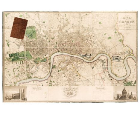
London. Greenwood (C & J), Map of London from an actual survey made in the years 1824, 1825 & 1826..., Greenwood & Co, 1st edition, August 21st, 1827, large scale map engraved by James & Josiah Neele with contemporary colouring, sectionalised and laid on linen, calligraphic title, inset views of St Pauls and Westminster, dedication to King George IV, reference to the parishes and table of explanation, some offsetting, edged in green silk with slight fraying, 1260 x 1855 mm, bookplate of L. C. Berger to verso, contained within contemporary tree calf book box (rubbed and slightly worn) QTY: (1)NOTE:Howgego 309. The largest and finest map of London to be printed in the 19th century. The Greenwood brothers spent three years preparing this remarkable new survey, illustrating for the first time the planned development of Belgravia by Thomas Cubitt, the completion of the Grand Surrey Canal and Regent's Park one year before it was finished in 1828. No map provided greater detail or accuracy until the Ordnance Survey.
Lot 79
British Isles. Elwe (Ian), Les Isles Britannique qui contiennent les Royaumes d'Angleterre, Ecosse et Irlande..., Amsterdam, 1792, engraved map with contemporary wash colouring, inset map of the Shetland and Orkney Islands, slight overall dust soiling, very slight creasing, 475 x 595 mm, together with Jaillot (Hubert). Les Isles Britanniques qui contiennent les Royaumes d' Angleterre, Escosse et Irlande..., circa 1709, engraved map with contemporary outline colouring, inset map of the Shetland, Orkney and the Faroe Islands, decorative cartouche and mileage scale, 465 x 655 mm, with Faden (W.). A Map of England, Wales & Scotland describing all the Direct and Principal Cross Roads in Great Britain..., Aug. 12th 1800, engraved map with bright contemporary wash colouring, inset map of Scotland, very slight staining, 735 x 606 mm, plus Mercator (Gerard). Eboracum, Lincolnia, Derbia, Staffordia, Notinghamia, Lecestria, Rutlandia et Nofolcia, circa 1600, engraved map of north-east England with contemporary outline colouring, large strapwork cartouche, 360 x 420 mm, French text on verso, and another eight maps of England & Wales, including examples by or after Wilkinson, Bradshaw, Le Rouge and Stieler, various sizes and condition QTY: (12)
Lot 251
Hammond (Henry). A Paraphrase, and Annotations upon all the Books of the New Testament: Briefly explaining all the difficult places thereof, London: Printed by J. Flesher for Richard Royston, 1653, title with etched illustration, also with 18th-century ownership inscription 'Samuel Taylor M.A. Vicr. of Quinton in Gloucestershire: and late Rector of Saint Clement in Worcester, 1738', advert leaf present at rear, light worming to upper and lower margins of initial few leaves and damp-stain at head of last few leaves, front endpapers with 18th and 19th-century ownership inscriptions of Robert Etherington and Samuel Taylor Etherington of Tutbury and Sudbury, contemporary calf, torn at head with loss, leather to boards also torn with some loss, worn, folio, together with:Book of Common Prayer, and Administration of the Sacraments, and other Rites and Ceremonies of the Church..., together with the Psalter or Psalms of David..., London: Printed by Charles Bill, and the Executrix of Thomas Newcomb, deceas'd, 1706, engraved frontispiece, title in red and black, margins ruled in red throughout, sewing weak at front of volume and some leaves loose/detached and frayed at edges, all edges gilt, contemporary gilt panelled and decorated red morocco, folio, plus two others Burkitt (William). Expository Notes, with Practical Observations, on the New Testament..., 13th edition, carefully corrected, London: R. Ware, J. and P. Knapton, S. Birt [et al.], 1752, engraved portrait frontispiece, title in red and black, numerous engraved plates (one folding) and folding engraved map at rear, contemporary calf, morocco title label to spine, joints cracked, extremities worn, folio, and Hooker (Richard). Of the Lawes of Ecclesiastical Politie, London: Andrew Crooke, 1666, engraved portrait frontispiece and engraved title, frontispiece detached and initial leaves frayed, damp staining and mottling throughout volume to lower margins with consequent damp-fraying particularly to lower inner corners, contemporary calf, spine torn with loss, worn, folioQTY: (4)
Lot 311
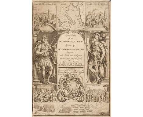
Hobbes (Thomas, translator). The History of the Grecian War: in Eight Books, written by Thucydides, 2nd edition, corrected and amended, 1676, engraved additional title, letterpress title printed in red and black, 3 folding and double-page engraved maps, 2 engraved plates, frontispiece and front endpapers detached (folding map a little frayed at margins, small light water stain), rear blank with 18th century annotations, previous owner signatures of Frances Shirley and J. B. Locke to letterpress title, bookplate of Robert Quirk (with manuscript date of 1903), contemporary calf, upper cover detached, rebacked with original spine relaid, label renewed, some edge wear, folio QTY: (1)NOTE:Provenance: Frances Shirley (Lady Frances Shirley, 1707-1778), signature to title.Wing T1134. First published in 1629, this is Thomas Hobbes' most famous translation and the first directly from the Greek. He also drew the ancient map of Greece.

Lot 82
Buckinghamshire. Speed (John), Buckingham Both Shyre and Shire Towne describ., published Thomas Bassett and Richard Chiswell, circa 1676, uncoloured engraved map, inset town plans of Reading and Buckingham, large margins, slight overall toning, 385 x 510 mm, English text on verso, together with Morden (Robert). Buckinghamshire [1695 or later], uncoloured engraved map, 420 x 350 mm, with Buckinghamshire, circa 1702, uncoloured engraved map, old folds, 255 x 155 mmQTY: (3)

Lot 98
Ireland. Jefferys (Thomas), A New and Accurate Map of the Kingdon of Ireland divided into Provinces, Counties and Baronies; with all the Cities, Boroughs, Post Towns, Barracks and Principal Villages..., printed for John Bowles, Robert Sayer, Thos. Jefferys and Carington Bowles [1759 - 75], engraved map with contemporary outline colouring, sectionalised and laid on linen, slight dust soiling, 650 x 605 mm, together with Carington Bowles (publisher). Bowles's New Pocket Map of the Kingdom of Ireland, Divided into its Provinces, Counties and Baronies..., 24th June 1779, engraved map with contemporary outline colouring, sectionalised and laid on linen, slight dust soiling and staining, 625 x 590 mm QTY: (2)NOTE:Andrew Bonar Law, The Printed Maps of Ireland, number 91 state 4 (Jeffreys) and 120 state 2 (Bowles).
Lot 95
Folding Maps. A collection of 23 maps, 18th & 19th century, 23 engraved and lithographic map sheets of British county and regional maps and foreign maps and plans, all sectionalised and laid on linen, including examples by or after Walker, Philips, Wyld (including a four sheet map of Europe), Bowen, J & C Walker, 'The Times', Ordnance Survey, Hebner, Ebden, Assheton, Brué (map of France on four sheets) and Darton & Dix (county maps of Essex and Bedfordshire), various sizes and conditionQTY: (23)

Lot 107
Liverpool. Gage (Michael Alexander), This Trigonometrical Plan of the Town and Port of Liverpool including the environs of Kirkdale Everton Lowhill Edge Hill & Toxteth from actual survey..., March 1st 1836, engraved map with contemporary outline colouring, sectionalised and laid on linen, calligraphic title, table of reference and additional information including tides, boundaries and history, dedication to William IV and compass rose, slight staining and offsetting, slight dust soiling to the margins, blind stamped cloth endpapers, 1050 x 1660 mm, contained within a contemporary cloth slipcase with a morocco gilt label to the upper cover, slipcase heavily worn and frayedQTY: (1)

Lot 8
Cheesman (Robert Ernest). In Unknown Arabia, with a Foreword by Major-General Sir Percy Z. Cox, 1st edition, London: Macmillan and Co., Limited, 1926, photographic frontispiece and plates, half-title (lightly toned), folding map, short closed tear to hinge of folding map, original dark green cloth gilt, spine slightly faded, slight rubbing with some loss of colour to head and foot of spine, 8vo,QTY: (1)
![Barrett (William). The History and Antiquities of the City of Bristol ..., Bristol: William Pine, [1789], folding engraved ma](https://cdn.globalauctionplatform.com/2c61f7bf-ae43-41de-bb88-b132012566a4/06df2a2f-bb96-4d88-9a8b-b13e010b8287/468x382.jpg)
Lot 28
Barrett (William). The History and Antiquities of the City of Bristol ..., Bristol: William Pine, [1789], folding engraved map, slightly edge-frayed, with closed handling tear and short split to inner fold, title with engraved printer's device, small hole to blank gutter, 29 engraved plates (correct as list, 14 folding), including Facsimile of Rowley's Manuscript, plates spotted and offset, extra-illustrated with two folding maps: Plan of the City and Suburbs of Bristol including Clifton & the Hotwells, Bristol: R.Edwards, November 1st 1799, and a facsimile of the 1671 map by I.M.: An Exact Delineation of the Famous Cittie of Bristoll and suburbs thereof, both folding and with a single short split to fold or closed edge tear, the former slightly edge-frayed, contemporary mottled calf gilt, rebacked, rubbed, minor wear to extremities, 4to, together with: Balch (Herbert E.), Wookey Hole, its Caves and Cave Dwellers, London [etc]: Humphrey Milford Oxford University Press, 1914, photogravure frontispiece, black & white illustrations, photogravures, and plans (some with hand-colouring), original linen-backed boards, some wear to corners, few minor marks, 4to, plus: Hamerton (Philip Gilbert), The Unknown River, London: Seeley, Jackson, and Halliday, 1871, mounted etched plates and title vignette, advertisement leaf at rear, binder's ticket of Hanbury & Simpson, Fleet St, all edges gilt, original blue cloth gilt, extremities rubbed, some stains and marks (mainly to rear cover), 4to, with 4 other titles, including: Bibliotheca Somersetensis, by Emanuel Green, 3 volumes, 1902, (ex. Brighton Public Library); Topographical Dictionary of Scotland, by S. Lewis, 2 volumes, 1846; Old English Household Life, by G. Jekyll, 1925; and West Country Churches, by W.J. Robinson, volume 3 only, 1915QTY: (10)
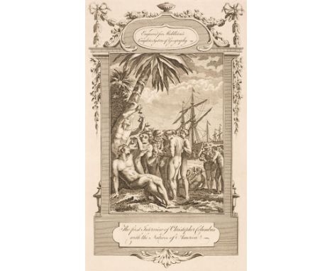
Lot 16
Middleton (Charles Theodore). A New and Complete System of Geography. Containing a full, accurate, authentic and interesting account and description of Europe, Asia, Africa, and America ..., 2 volumes, London: for J. Cooke, [1777-1778], vol.II title printed in red & black, 20 uncoloured engraved maps (including 7 folding), and 100 engraved plates, 4 maps with some edge fraying and chipping, one unfolded map (Scotland) with 3.5 cm closed edge tear, one folded map (North America) with central fold mostly split (with associated shorter tears and fraying), each front pastedown with early ink manuscript presentation label, inscribed in a calligraphic hand: Henry Budd, Southampton, to Henry Budd Blackmore of Hinton Ampner, both front hinges cracked, contemporary sprinkled calf, red morocco label to each spine, worn, 3 hinges cracked, vol. I rear cover detached, folioQTY: (2)
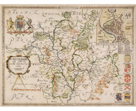
Lot 123
* Worcestershire. Saxton (Christopher & Lea Philip), Worcestershire and Citty exactly described by C. S. newly augmented by Phil. Lea [1689 - 94], hand-coloured engraved map, inset city plan of Worcester, strapwork cartouche and mileage scale, 375 x 500 mm, mounted, framed and glazedQTY: (1)
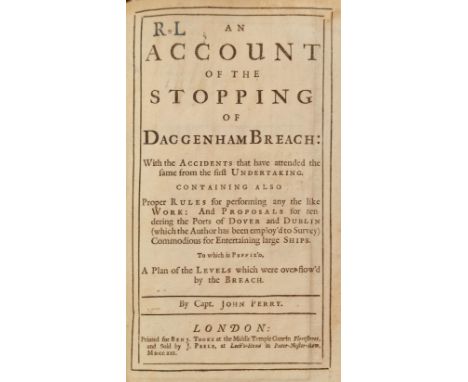
Lot 47
Perry (Capt. John). An Account of the Stopping of Daggenham Breach: with the Accidents that have attended the same from the first undertaking. Containing also proper rules for performing any the like work: and proposals for rendering the Ports of Dover and Dublin ... commodious for entertaining large ships. To which is prefix'd, a plan of the Levels which were overflow'd by the Breach, 1st edition, London: Benj. Tooke, 1721, title with early initial stamp R. L. at head and errata slip pasted to verso, folding engraved map by H.Moll, contemporary calf, joints slightly cracked, 8voQTY: (1)NOTE:An account of the engineering work undertaken by the hydraulic engineer John Perry in repairing two breaches in the Thames embankment at Dagenham, caused by storms and neglect.
Lot 49
Rudder (Samuel). A New History of Gloucestershire, comprising the topography, antiquities, curiosities, produce, trade, and manufactures of that county, 1st edition, Cirencester: Samuel Rudder, 1779, folding engraved county map, 14 engraved plates and two single-page plans, armorial bookplate of Thomas Wakeman to front pastedown, contemporary diced calf gilt, rebacked with original spine relaid, folio, together with:Bigland (Ralph). Historical, Monumental and Genealogical Collections, Relative to the County of Gloucester, 2 volumes in 1, 1st edition, London: John Nichols, 1791-92, volume 1 with 22 engraved plates, engraved armorial to dedication leaf, volume 2 with 10 (of 11) engraved plates, lacking pp.69-72 and pp.225-252, preliminary leaves frayed and wormed, a few large closed tears, endpapers renewed, ownership inscription of William Capel, The Grove to front pastedown, untrimmed, contemporary quarter vellum, manuscript titles, scuffed and frayed with loss, folio, plusRudder (Samuel). A New History of Gloucestershire, comprising the topography, antiquities, curiosities, produce, trade, and manufactures of that county, 1st edition, Cirencester: Samuel Rudder, 1779, folding engraved map frontipiece (slightly browned and torn, with repairs on verso), 4 (of 17 plates), ownership inscription to title 'John Small Junr His Booke Octr 5: 1779', hinges strengthened with fabric tape, contemporary mottled calf gilt, rebacked, extremities. rubbed and head of spine slightly frayed, folioQTY: (3)
Lot 465
Ticehurst (Claud B.). A History of the Birds of Suffolk, 1st edition, London: Gurney and Jackson, 1932, monochrome illustrations, some light marginal toning, original green cloth, spine lightly faded & rubbed to head & foot, 8vo, together with:Bucknill (John A.), The Birds of Surrey, 1st edition, London: R. H. Porter, 1900, monochrome illustrations & map, front & rear gutters cracked, some light spotting & toning throughout, original red cloth, boards & spine slightly rubbed to head & foot, 8vo, plusAplin (O. V.), The Birds of Oxfordshire, 1st edition, Oxford: Clarendon Press, 1889, hand coloured frontispiece, monochrome map, some minor marginal toning, original blue cloth, spine lightly faded, boards & spine very lightly rubbed to head & foot, 8vo, and other late 19th century & modern ornithology reference, including The Birds of The British Isles, 12 volumes, by David A. Bannerman & George E. Lodge, circa 1950s-60s, all original cloth in dust jackets, large 8vo, some paperback editions, mostly original cloth, some in dust jackets, G/VG, 8voQTY: (6 shelves)

Lot 1
Baedeker (Karl). Egypt, Handbook for Travellers edited by K. Baedker, Part Second: Upper Egypt with Nubia as far as the Second Cataract and the Western Oases, Leipzig & London: Karl Baedeker, 1892, & Palestine and Syria with the chief routes through Mesopotamia and Babylonia, 4th edition, Leipzig and London, Karl Baedeker, 1906, colour maps and plans etc., including some folding, both original red cloth gilt, first volume a little rubbed and lightly soiled, 8vo, together withNordhoff (Charles). California: For Health, Pleasure, and Residence, a book for travellers and settlers, 1st edition, New York: Harper & Brothers, 1874, single-page map frontispiece, wood-engraved illustrations, original green cloth gilt, a little rubbed, large 8vo, plusFergusson (James). History of Indian and Eastern Architecture, 2 volumes, 1st edition, London: John Murray, 1910, numerous monochrome illustrations, top edge gilt, modern maroon cloth gilt, thick 8vo, and other various travel interest including Baedeker Guides (Japan, 8th edition, 1907, another copy of Palestine and Syria, 4th edition, 1906, Greece, 4th edition, 1909, and Northern Italy, 1886), Cook's Traveller's Handbook for Palestine and Syria by Roy Elston, 1929, C. C. Ghosh, The Silk Industry of Japan with notes on observations in the United States of America, England, France, and Italy, Delhi: 1933, etc.QTY: (17)
Lot 116
Surrey. Bryant (Andrew), Map of the County of Surrey from actual survey by A. Bryant in the years 1822 and 1823..., June 1st 1823, large scale engraved map with contemporary colouring, sectionalised and laid on linen, calligraphic title and compass rose, list of ecclesiastical divisions and table of explanation, some offsetting, edged in green silk with slight fraying, green endpapers, 1510 x 1955 mm, contained within contemporary book box (very rubbed and worn with loss)QTY: (1)
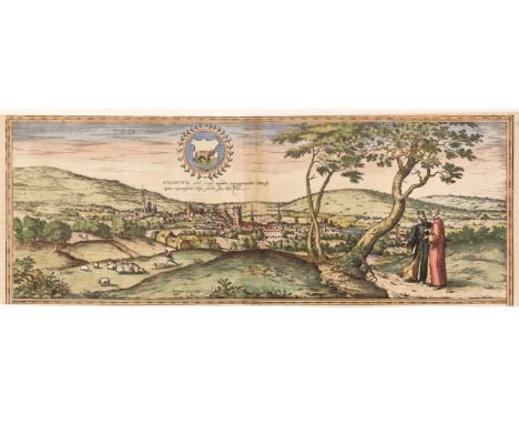
Lot 75
Braun (Georg & Hogenberg Franz). Oxonium nobile Anglie oppidum Septenrionalem..., circa 1575, an engraved panorama of Oxford with contemporary hand-colouring, thread margins along the horizontal borders, slight toning to the central fold, 180 x 485 mm, together with Saxton (Christopher & Hole G.). Buckingham comitatus in quo olim Insederunt Cattieuchlani [1610], uncoloured engraved map, large strapwork cartouche and mileage scale, 275 x 290 mm, with Kitchin (Thomas). Hampshire Drawn from the best Surveys & Maps..., circa 1786, hand-coloured engraved map, 175 x 220 mm, supplied with a page of descriptive text, plus Royce (John). A Plan of the Canals now making from the several Coal Mines in the neighbourhood of Stourbridge and Dudley to the Great Canal from the Trent to the Severn near Stourton in the County of Stafford, Survey'd in 1775 by Robert Whitworth, circa 1776, uncoloured engraved canal map, old folds, repaired tear to the right - hand vertical margin, but not affecting the printed image, 175 x 370 mmQTY: (4)
Lot 81
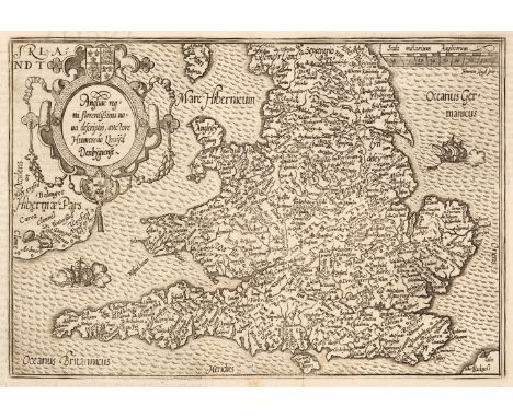
British Isles. Quad (Matthias), Angliae regni florentisimi nova descriptio auctore Humeredo Lhuyd Denbygiense, Cologne [1592 - 1608], uncoloured engraved map, slight dust soiling and text show through, large margins, 185 x 265 mm, Latin text on verso, together with Jansson (Jan, Mercator Gerard & Hondius H.). Anglia, circa 1634, hand-coloured engraved map, originally published in the 'Atlas Minor', 150 x 200 mm, Latin text on verso, framed and double-glazed QTY: (2)NOTE:R. W. Shirley, Early Printed Maps of the British Isles 1477 - 1650, 172 (Quad), and 402 (Jansson).


Lot 108
London. Cruchley (G. F.). Cruchley's New Plan of London Improved to 1827. Including the East and West India Docks, 1827, engraved map with contemporary outline colouring, sectionalised and laid on linen, slight staining, some dust soiling, 460 x 935 mm, marbled endpapers, contained in a contemporary green marbled slipcase with publisher's yellow printed label to the upper cover, some wear and ink staining, together with Bowles & Carver (publisher). Bowles's Reduced New Pocket Plan of the Cities of London and Westminster with the Borough of Southwark exhibiting the New Buildings to 1799, engraved map with contemporary outline colouring, sectionalised and laid on linen, several splits along old linen folds, some dust staining and creasing, 390 x 555 mm, contained in a contemporary marbled card slipcase with publisher's printed labels to both covers, some wear to the extremities, with Andrews (J.). Andrews's New and Accurate Map of the Country Thirty Miles Round London..., 4th edition, James Heskett, August 1st 1820, engraved map with contemporary outline colouring, sectionalised and laid on linen, very slight staining, 685 x 635 mm, lacking slipcase, plus Froggett (John Walter). Froggett's Survey of the Country Thirty Miles Round London, May 1st 1832, engraved map with contemporary outline colouring, sectionalised and laid on linen, very slight staining, 1090 x 1365 mm, later biro annotations to the endpapers, contained in a modern green cloth slipcase and Cruchley (G. F.). Cruchley's Twelve Miles Round London, 1826, engraved circular map with contemporary outline colouring, sectionalised and laid on linen, some offsetting, 380 x 380 mm, marbled endpapers, contained in a contemporary green marbled slipcase with publisher's yellow printed label to the upper cover, some wear, and another seven folding maps of London, including examples by or after Cary, Bacon, W. H. Smith and Bartholomew, various sizes and condition QTY: (12)NOTE:James Howgego. Printed Maps of London, numbers 304 (2nd edition, state B), 158a (state 11), 172 (state 5), 333 (state 1a) and not listed.

Lot 32
Butcher (Edmund). Sidmouth Scenery; or, Views of the Principal Cottages and Residences of the Nobility and Gentry: with a description of that admired Watering-Place, and the environs, within fifteen miles round, 1st edition, 1st issue, Sidmouth: John Wallis, circa 1819, folding hand-coloured aquatint frontispiece view of Sidmouth, additional hand-coloured aquatint title with view of Knole Cottage, 20 hand-coloured aquatint plates by H. Haseler, additional leaf at rear with engraved map to text of Sidmouth, list of subscribers, lightly spotted, contemporary mottled calf gilt, rubbed, 8voQTY: (1)NOTE:Abbey Scenery 307.There were two issues of this book of views, the first, as here, with a total of 22 plates (including frontispiece & additional title), and the second with a total of 24 plates (including frontispiece & additional title).

Lot 14
Livingstone (David). A Narrative of Dr. Livingston's Discoveries in South-Central Africa, from 1849 to 1856, 1st edition thus, London: Routledge and Co., 1857, folding map frontispiece, spotting to fore-edge, original pictorial paper-covered boards, rebacked (with endpapers renewed), rubbed, 8voQTY: (1)NOTE:The first appearance in book form of Livingstone's travels in Africa (the preface dated January, 1857). The same author's Missionary Travels and Researches in South Africa did not appear until November of the same year. 'In giving to the world the first authentic narrative of the important explorations of the Rev. Dr. Livingstone, the publishers have to acknowledge their obligations to the spirited conductors of the British Banner, in whose columns, in detached portions, this remarkable history first appeared' (Preface).
Lot 93
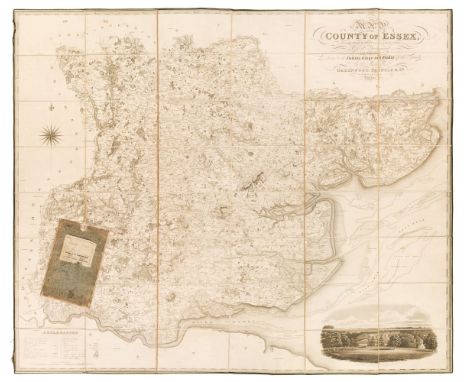
Essex. Greenwood (C & J), Map of the County of Essex, from an actual survey made in the year 1824..., Greenwood, Pringle & Co. July 1st 1825, large scale uncoloured engraved map, sectionalised and laid on linen, calligraphic cartouche, table of explanation, compass rose and a vignette view of Audley End House, edged in green silk with some fraying, some offsetting and spotting, 1330 x 1570 mm, contained in a later slipcase (rubbed) QTY: (1)
Lot 39
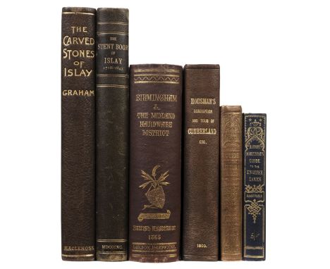
Graham (Robert. C.). The Carved Stones of Islay, Glasgow: James Maclehose and Sons, 1895, half-title, additional etched decorative title on cream Japon vellum, ink inscription to verso of half-title 'This is one of the copies with plates on Japanese of which only sixty five(?) copies are for sale' indistinctly signed (possibly by publisher), map, 32 photogravures and other illustrations, some scattered spotting, top edge gilt, remainder untrimmed, original quarter morocco gilt, upper board corners rubbed with small loss, gilt title to spine, a little rubbed and minor wear at head of spine, 4to, together withRamsay (Lucy). The Stent Book and Acts of the Balliary of Islay, 1718-1843, privately printed, 1890, half-title, title-page with engraving of map of Islay, plate of signatures, blue endpapers, original half morocco gilt, some marks and rubbing to extremities, gilt title to spine, 4to, limited to 250 copies, plus four other topography books comprising: The Resources, Products and Industrial History of Birmingham...edited by Samuel Timmins, 1866; A Topographical Description of Cumberland, Westmoreland, Lancashire and a part of The West Riding of Yorkshire...by John Housman, 1800, A Complete Guide to the English Lakes by Harriet Martineau, [1855], and A Complete Guide to the English Lakes...by Rev. Professor Sedgwick, 1859, all 8voQTY: (6)

Lot 94
Exeter. Braun (Georg & Hogenberg Frans), Civitas Exoniae (vulgo Excester) Urbs Primaria in Comitatu Devoniae, circa 1617, hand-coloured engraved city plan, repaired closed tear, slight text show through, large margins, 315 x 400 mm, Latin text on verso, together with Meisner (Daniel). Immoderatus Amorinteritum Causat, circa 1638, uncoloured engraved city plan, printers fold and some marginal spotting, 100 x 145 mm, with Hermannides (Rutger). Exonia Excester, circa 1661, uncoloured engraved map, old folds, old tape hinges in the upper margin, 110 x 130 mm, plus Rapkin (J.). Exeter, circa 1860, uncoloured engraved decorative city plan, 260 x 340 mm, and Roper (J.). Exeter, 1805, uncoloured engraved city plan, vignette of Exeter Cathedral, 240 x 180 mm, with Mutlow (J.). Civitas Exoniae (vulgo Excester) Urbs primaria in Comitatu Deconiae, circa 1820, uncoloured engraved plan, reduced from Braun and Hogenberg's earlier engraving, slight staining, short marginal closed tear, 220 x 275 mm, with one other similar QTY: (7)
![* Derbyshire. Speed (John), Anno Darbieshire described, Thomas Bassett & Richard Chiswell [1676], hand-coloured engraved](https://cdn.globalauctionplatform.com/2c61f7bf-ae43-41de-bb88-b132012566a4/c72980e8-14fd-48dc-b7cb-b13e010b9d3b/468x382.jpg)
Lot 88
* Derbyshire. Speed (John), Anno Darbieshire described, Thomas Bassett & Richard Chiswell [1676], hand-coloured engraved map, inset town plan of Derby and a vignette of St. Anne's Well at Buxton, large strapwork cartouche and compass rose, large margins, 385 x 510 mm, mounted, framed and double-glazed, English text on verso, together with Blaeu (Johannes). Darbiensis Comitatus Vernacule Darbie Shire, Amsterdam circa 1646, engraved map with contemporary outline colouring, large allegorical cartouche and mileage scale, 385 x 505 mm, German text on versoQTY: (2)
-
108737 item(s)/page