We found 109198 price guide item(s) matching your search
There are 109198 lots that match your search criteria. Subscribe now to get instant access to the full price guide service.
Click here to subscribe- List
- Grid
-
109198 item(s)/page


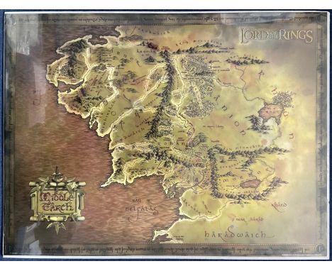
Lot 137
Unusual Highly Collectable Lord of the Rings Presentation Map Showing Middle Earth. Gold Effect. Measures 31. 5 x 23. 5 inches overall. Good condition. All autographs come with a Certificate of Authenticity. We combine postage on multiple winning lots and can ship worldwide. UK postage from £5.99, EU from £7.99, Rest of World from £9.99


Lot 1709
A collection of Channel Islands (Guernsey) postcards and ephemera etc, to include a RPPC "Vale Coronation Celebration, July. 1911; photographs of a Mill and Police headquarters; In Loving Memory cards, various Guernsey families, the earliest 1889; two-part 1938 Lancresse Bay map; bowling pin badges, together with various other souvenir photo cards etc, some Channel Islands, etc. (quantity)
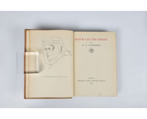
Lot 1720
Lawrence (T. E.), Seven Pillars Of Wisdom, a triumph, first trade edition, 1935, original gilt decorated tan cloth, monochrome illustrations and folding maps, 4to, spine faded, shaken, cracked hinge at title, light spotting; together with Lawrence (T.E.), Revolt in the Desert, 4th imp. March 1927, monochrome illustrations and folding map, 8vo, original buff cloth, cloth soiled, ep's toned, occasional spotting. (2) - Seven Pillars Of Wisdom: spine faded, shaken, cracked hinge at title, light spotting - Revolt in the Desert: cloth soiled, ep's toned, occasional spotting.


Lot 926
“Map of Kent with her Cities and Earles Described and Observed”,, John Speed, Kent county map with inset maps of Rochester and Canterbury, decorative strapwork cartouche, with seven armorials and Royal coat of arms with supporters to top edge, engraving with hand-colouring. On wove paper, a 19th century copy of the earlier map, framed behind glass, 16½ x 21¼in. (41.9 x 53.1cm.).. Time stained


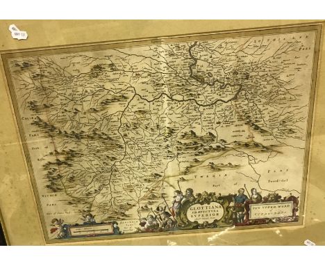
Lot 509
AFTER JOHANNES BLAEU & TIMOTHY PONT "Glottiana - the upper ward of Cyds-dayi" black and white engraved map, later coloured. 40 cm x 54 cm together with AFTER W & J BLAEW "Herefordshire" black and white engraved map, later coloured with French text verso, 41.5 cm x 50 cm together with AFTER E HASTED "A map of the Hundreds of Stowing Street and Heane ... " black and white engraved map, later coloured, 46 cm x 38.5 cm and AFTER JOHN OGILBY "The road from Bristoll to Worcester" black and white engraved strip map, later coloured, 32 cm x 45 cm CONDITION REPORTS These are originals. Glottiana is framed and glazed. The others not - see images for further detail
Lot 302
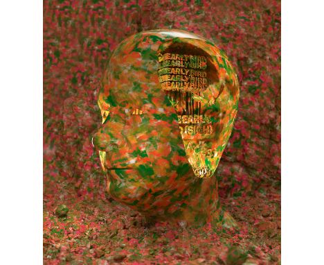
Berresheim, Tim1975 HeinsbergTitel: "Haruspex - Early Bird". Datierung: 2022. Eigentümer: Tim Berresheim. Token ID: 1. Token Type: NFT, ERC-721. Blockchain: Ethereum. Tokenisiert durch: Time To Token. Smart Contract: 0x61150522381Da7f63EE9D6Df94d718907f989757. Royalties: 10 %. Media Storage: Arweave. Dateiformat: ZIP (auf USB-Stick). Dateigröße: 552,2 MB.+Physisches Kunstwerk:Titel: "Haruspex - Early Bird".Datierung: 2022.Technik: Baryt.Maße: 70 x 120cm.Bezeichnung: Verso auf Aufkleber signiert, datiert, betitelt und bezeichnet: STUDIOS NEW AMERIKA Haruspex. Early Bird. Baryt 2022 70 cm x 120 cm TB22/PH-880 W{|CC|RRR|+} Tim Berresheim - AACHEN.Rahmen/Sockel: Rahmen.Hybrides NFT (NFT + Print)"Haruspex - Early Bird" ist das Debut-NFT von Tim Berresheim.Erstmals erstellte er einen NFT mit der Berechtigung, dass die digitale Arbeit in der Zukunft als physischer Print gedruckt werden darf, sofern es die Technik zulässt. Zusätzlich zu dem NFT erhält der Sammler oder die Sammlerin bereits heute einen physischen Print zur digitalen Arbeit.Tim Berresheim untersucht in seinem künstlerischen Werk die Beziehung zwischen Kunst und Technologie und den Einfluss des drei- und mehrdimensionalen, illusionistischen Raums auf seine Kompositionen. Mit "Haruspex - Early Bird" präsentiert der Künstler ein komplexes Werk, das die Grenzen der Überführung des digitalen Renderings in die reale Welt aufbricht, indem es über zukünftige technologische Entwicklungen spekuliert. Sein "Haruspex" (Haruspex ist ein römischer Priester, der über Zeichen die Zukunft vorhersagt) liefert digitale Zusatzinformationen aus der digitalen Arbeit, die in Zukunft auch in die reale Welt überführt werden können. Als "Early Bird" macht Tim Berresheim somit seine digitale Arbeit schon jetzt für Sammler oder Sammlerinnen physisch zugänglich.Auch im digitalen Zeitalter stößt die Technik an die Grenzen des real Darstellbaren. Manches digitale Farbenspektrum ist heute schlichtweg noch nicht druckbar und macht es Künstlern und Künstlerinnen unmöglich, ihre digitale Kunst als gleichwertigen Print anzubieten. Mittels NFT hat Tim Berresheim einen Weg gefunden, seine digitale Arbeit bereits heute Sammlern oder Sammlerinnen als zukünftigen physischen Druck zu versprechen. Im NFT verbrieft der Künstler neben Informationen zu Belichtung und Farbe 13 weitere zu den Outputs von Depth Map, Albedo, Denoise Albedo Noisy, Diffuse Direct, Diffuse, ID, Indirect, N, P, Raycount, Specular Albedo, Specular Direct und Specular Indirect aus seiner digitalen Arbeit, die auf einem USB-Stick mitgeliefert werden. Sobald es die Technik erlaubt, kann sich der Sammler oder die Sammlerin die digitale Arbeit als gleichwertige physische Arbeit produzieren lassen. Um die technische Grenze, mit der sich Tim Berresheim in dieser Arbeit konfrontiert sah, auch für die Zukunft festzuhalten, bietet der Künstler schon heute einen Print an, der später neben den neuen, ausgereiften Druck seines digitalen Kunstwerks gestellt werden kann.Repräsentiert durch die SNA - Studios New Amerika GmbH.Bezahlung auch mit der Kryptowährung Ether (ETH) möglich.Neben unseren AGB gelten zudem die Sonderbedingungen für Versteigerungen von NFTs. Dieses Objekt wird regelbesteuert verkauft. (AGB §V5.1) Tim Berresheim Deutschland Digitale Kunst Zeitgenössische Kunst NFT Wahrsagung NFT Digitale Kunst ZukunftErläuterungen zum KatalogErläuterungen zum Katalog


![[WORLD WAR II]: A printed softcover 8vo booklet containing over 100 maps of British towns and cities, published by the Army G](https://cdn.globalauctionplatform.com/de6c7e0b-c5e1-4588-a7bd-af3f0123225a/256264e0-8ce7-4ff8-a99d-af4200fb2b49/468x382.jpg)
Lot 1097
[WORLD WAR II]: A printed softcover 8vo booklet containing over 100 maps of British towns and cities, published by the Army General Staff, Department of War Maps and Surveying, Berlin, 1940, the front cover marked as to be used only by members of the service and indicating that the maps were up-to-date as of 30th June 1940. Issued ahead of Germany's intended invasion of England in the autumn of 1940, the booklet features alphabetically ordered maps (some of them folding out) of various towns and cities including Aldershot, Bath, Birmingham, Blackpool, Bristol, Cardiff, Coventry, Derby, Ipswich, Leeds, Liverpool, Manchester, Nottingham, Portsmouth, Sheffield, Torquay, Truro, Wigan, Wolverhampton and York etc. Each map names various roads and streets as well as identifying rivers and other places of interest (sports grounds, railway stations etc.). London is not included. Some light overall age wear and minor staining to the grey and black printed cloth wrappers. About VG

Lot 870
LA CONDAMINE CHARLES MARIE DE: (1701-1774) French Explorer, Geographer and Mathematician. He measured the length of a degree latitude at the equator, spending ten years in Ecuador, and prepared the first map of the Amazon. Rare A.L.S., `La Condamine´, one page, 8vo, n.p., 11th December 1752, in French. La Condamine states `Je reçois dans le moment, Monsieur, par un courier du cabinet arrivant de berlin un paquet de M. de Maupertuis avec deux exemplaires de ses lettres dont un pour vous que j´ai l´honneur de vous envoyer´ (Translation: "I have received right now, Sir, by a courier of the cabinet, arriving from Berlin, a parcel from M. de Maupertuis containing two copies of his letters, one of them for you which I am honoured sending to you") La Condamine referring to Maupertuis, further states `Sa santé est un peu meilleure. Le roi est venu passer quelques heures à Berlin et lui a fait dire que son intention avait été d'aller le voir, mais que les affaires l'en avaient empêché… Vous aurez vu la lettre apologétique du roi qu'on imprime actuellement, ainsi que le tombeau de la Sorbonne…´ ("His health is a little better. The King came to spend a few hours in Berlin and told him that his intention had been to go and see him, but that work had prevented him from doing so... You will have seen the King's apologetic letter which is currently being printed, as well as that the tomb of the Sorbonne…") Tear to the bottom right edge, not affecting the text or the signature. Overall minor age wear, clipped right bottom corner and few small stains, otherwise G Pierre Louis Maupertuis(1698-1759) French Mathematician and Philosopher. Maupertuis was the first President of the Prussian Academy of Sciences at the invitation of Frederick the Great. He is credited with the invention of the "Principle of Least Action", and the Maupertuis´s principle, an integral equation that determines the path followed by a physical system, is named after him.


Lot 272
Eman. BowenAn Accurate Map of the County of Gloucester divided into Hundreds, drawn from the best authorities and illustrated with historical extracts...with a view of the Cathedral Church...'printed for R. Sayer and I. Ryall in Fleet St. T Kitchin on Holborn Hill etc., hand coloured, with creases in the centre of the map (probably where it has slipped in the mount), 50 x 42cm approx, framed and glazed


Lot 334
The Benny Hill Show - Thames Television - an original rehearsal script from 'Show 1' of The Benny Hill Show, recorded on 4th December 1987. Pink cover, with white pages. 58pp. Includes a map page and information on rehearsal and recording dates. This script belonged to supporting actor Bob Todd. Complete script.
Lot 842
NINETY SEVEN TITLES RELATING TO ANTIQUE INDIAN ARMS AND ARMOUR, ART AND HISTORY, comprising 'Indian Arms and Armour Vol. 1', G N Pant, 1978 with DW; 'The Adventures of Hamza', large V & A Exhibition book of 16th century illustrations, with DW (new condition, sealed); 'An Illustrated Handbook of Indian Arms', Hon. W Egerton, W H Allen 1880 (rebound); 'Catalogue of Urdu Books in the India Office Library 1800-1920', S Al-Din Quraishi, British Library 1991; 'Catalogue of the Collection of Indian Arms . . . now in the India Room at Marlborough House 1898', C Purdon Clarke 1898 (photocopy); 'Economic Products of India Exhibited at the Calcutta International Exhibition 1883-84', G Watt (reprint, soft covers); 'Sword of the Raj - the British Army in India', R Beaumont 1977 with DW; 'Palaces of the Raj', M Bence-Jones 1973 with DW; 'A Man of the Enlightenment in Eighteenth Century India - the Letters of Claude Martin 1766-1800', R Llewelyn-Jones (Ex. Public library); 'Indian Miniatures', M Bussagli 1969 with DW (Ex. Public library); 'Arts and Crafts in India', Cooper and Gillow 1996, soft covers; a large road map of India d.1940; and approx. eighty five assorted Islamic and Indian sale catalogues from Sotheby's, Christies and Bonhams 1976-2013. Average good condition (97).

Lot 100
Cunningham (C.D.) and Abney (Captain W. de W.) The Pioneers of the Alps, 4to, cloth, illus., 1887; Gos (Francois) (F.F. Roget trans.) Zermatt and Its Valley, 8vo, cloth, illus. with fold-out map and plates, nd; Zincke (F.B.) Swiss Allmends, 8vo, gilt cloth, 1874; and two other books on alpine climbing.


Lot 114
Otley (Jonathan) A Concise Description of the English Lanes and Adjacent Mountains, sml. 8vo, cloth, illus. with fold-out map, Keswick 1830; and Rowbotham (Thomas L.), Needham (J.), Keene (W.C.) and other Artists, Our Native Land: Its Scenery and Associations, 4to, quarter calf, illus. with 36 chromolithographs, 1879.


Lot 118
Kennedy-Fraser (Marjory) Songs of the Hebrides, 2 Vols, lge. 4to, boards, Boosey & Co., 1909; Kennedy-Fraser (Marjory) and MacLeod (Kenneth) From the Hebrides, lge. 4to, cloth, Glasgow, nd; Humble (B.H.) The Songs of Skye, sml. 8vo, boards, illus. with fold-out plates, Stirling, 1934; Lauder (Sir Thomas Dick) Scottish Rivers, 8vo, cloth, illus., Glasgow 1890; Brown (P. Hume) Scotland Before 1700 From Contemporary Documents, 8vo, cloth, illus. with fold-out map, Edinburgh 1893; and other books on Scottish subjects. (13)


Lot 144
Thompson (John Vaughan) A Catalgoue of Plants Growing in the Vicinity of Berwick upon Tweed, 8vo, boards, illus. with hand-coloured plate and title page vignette, 1807; Baker (J.G.) and Tate (G.R.) A New Flora of Northumberland and Durham, Vol. 2, 8vo, cloth, illus. with fold-out map, Tyneside Naturalists' Field Club, 1868; and other books on natural history and geology. (12)


Lot 180
Richardson (William) The History of the Parish of Wallsend, 8vo, cloth, illus. with fold-out map, Newcastle 1923; T. & G. Allan (Printers) The Seige and Storming of Newcastle, 1644, 4to, paper covs, illus., Newcastle 1933l; Dodd (William) Brand's Index to the History of Newcastle upon Tyne, 4to, unbound, Newcastle 1881; Boans (Henry) The Fatal Error: A Tragedy, sml. 8vo, unbound, Gateshead 1885; Brockett (J.P.) (Editor) The Scots Martch (sic) From Barwick to Newcastle, 8vo, original paper wrappers, Newcastle 1827; and a North of England Joint Stock Certificate engraved by Mark Lambert.

Lot 233
Scott (W.) The Border Exploits, sml. 8vo, full calf, illus. with map and engravings, Hawick 1812; William (Lord Bishop of Carlisle) Leges Marchiarum, Or Border Laws, 8vo, quarter calf and decorated boards, 1705, bearing the bookplate of John Waldie; and Hume (J.D.) A Border History of England and Scotland, 8vo, half calf, with woodcut frontispiece, Berwick, nd.

Lot 236
Donkin (Samuel) Reminiscences Of Northumbrian and Border Character, etc., 8vo, printed cloth, Newcastle 1886; Forster (R.H.) The Last Foray, 8vo, cloth, 1903; Pendered (Mary L.) John Martin, Painter, His Life & Times, 8vo, cloth, illus. with map and plates, 1923, with dw; Watson (Angus) My Life An Autobiography, 8vo, cloth, illus., 1937; and other Northern biographies. (15)

Lot 242
Jones (S.S.) Northumberland and Its Neighbour Lands, 4to, half morocco, illus., Newcastle nd; Register of the Electors for the Northern Division of the County of Northumberland 1880, 4to, paper covs, Newcastle 1879; Cox (Thomas) A Topographical, Ecclesiastical and Natural History of Northumberland, sml. 4to, half calf and marbled boards, with Morden's map of Northumberland and specially printed title page, 1700; and three other books on Northumberland.

Lot 244
Cox (Thomas) A Topographical, Ecclesiastical and Natural History of Northumberland (part work, pages 599-762), 4to, marbled boards, illus. with engravings and mileage chart, c.1700; Andrews (William) Bygone Northumberland, 8vo, cloth, illus., 1899; A Historical and Descriptive View of the County of Northumberland, 2 Vols, 8vo, full calf, illus. with fold-out map, printed and published by Mackenzie & Dent, Newcastle upon Tyne 1811; and two other books on Northumberland.

Lot 260
Maclean (J.S.) The Locomotives of the North Eastern Railway 1854-1905, obl., gilt cloth, illus., Newcastle, nd; Reid (B. Leo) North Country Clock Makers of the 17th, 18th and 19th Centuries, 8vo, original paper covs, illus., Newcastle 1925, presentation copy signed by the Author; another copy of Reid's North Country Clock Makers, in cloth bindings; Scott's Railway Companion to the Newcastle & Carlisle Railway, 32mo, original printed boards, illus. with fold-out map, Carlisle 1837; Boazman's Diary and Time Table for Trains, Trams, Steamers, Tides, etc., 48mo, printed paper covs, twentieth edition 1904; and other books on Northern Industry and Manufacture. (11)

Lot 267
Fynes (Richard) The Miners of Northumberland and Durham, sml. 8vo, quarter calf, illus., Blyth 1873; Gardner (Ralph) Englands Grievance Discovered In Relation To The Coal Trade, 8vo, marbled boards, illus. with map of the River Tyne, Newcastle 1796; another copy in half calf bindings, republished by Philipson & Hare, North Shields 1849; and Sopwith (T.) An Account of the Mining Districts of Alston Moor, 8vo, boards, illus. with hand-coloured map, Alnwick 1833.

Lot 269
Simpson (John Bell) The Presidential Address To The Institution of Mining Engineers General Meeting at London, June 2nd 1910, on the Subject of Coal Mining by the Monks in Northumberland, original paper covs. enclosed by modern 8vo. binding, illus. with fold-out map, presentation copy with an autographed letter from the Author tipped-in, and bearing the bookplate of John Crawford Hodgson; Sopwith (T.) An Account of the Mining District of Alston Moor, sml. 8vo, boards, illus. with hand-coloured map, Alnwick 1833; Lister (George) Chronological Records of Coal Mining, Transport, etc., in Northumberland and Durham 1180-1839, sml. 8vo, paper covs, third edition, Consett 1948; Forster (Westgarth) A Treatise on the Section of the Strata From Newcastle upon Tyne to Croft Fell, 8vo, cloth, illus. with fold-out plans and diagrams, third edition, revised and corrected by the Rev. W. Nall, Newcastle 1883; and three other books on lead mining.

Lot 289
MacBride (MacKenzie) Quaint Alston: A Leaf from Border History, 8vo, printed paper covs, illus. with fold-out map, Penrith nd; White (Walter) Northumberland and the Border, 8vo, illus. with fold-out map, second edition 1859; Woodman (William) Ugham Its Story, sml. 4to, quart calf and boards, with half-title woodcut frontispiece, bearing the bookplate of J. Creswell; Graham (P. Anderson) Highways and Byways in Northumberland, 8vo, cloth, illus. by Hugh Thomson, 1921; Batty (George L.) and Spowart (Philip) The Complete Guide to Berwick upon Tweed and Its Picturesque Neighbourhood, 12mo, printed paper covs, Berwick 1907; and The Official Guide to North Berwick 1940.
Lot 47
Wyld (James) The Great Western Railway Guide for Cheltenham & Western, and Bristol & Exeter, 32mo, illus. with fold-out maps, 1839; The British Railways Rule Book 1950 (reprint amended version 1961), Bradshaw's Railway Companion, 1840, with map, in leather slip case; The East African Railways and Harbours Motive Power Annual, Nairobi 1958; and The Great Western Railway Paperback Guide 'Through the Window', Vol. 1, Paddington to Penzance, nd. (5)

Lot 58
Chapman (Abel) The Borders and Beyond, sml. 4to, cloth, illus. by W.H. Riddell and the Author 1924; complete with a New Year's greetings card signed by the Author; and a printed portrait of the Author on the shooting field, attached to the preliminary pages, the personal copy of Howard Pease of Otterburn Tower, Northumberland; and Bird-Life of the Borders, sml. 8vo, cloth, illus. with fold-out map and plates, 1907, Wartime presentation label bearing the Artist's facsimile signature, pasted to the inside front cover.
Lot 98
Capper (Benjamin Pitts) A Topographical Dictionary of the United Kingdom, 8vo, half calf and marbled boards, illus. with maps and fold-out frontispiece, 1825; Guthrie (William) A New Geographical, Historical and Commercial Grammer of the Several Kingdoms of the World, 8vo, full calf, illus. with fold-out maps, twelfth edition 1790; L'Abbé Barthélemy, Voyage Du Jeune Anacharsis en Grece, sml. 8vo, full calf, illus. with fold-out map, French text, London 1824; Wade (John) The Cabinet Gazetteer: A Popular Exposition of the Countries of the World, etc., sml. 8vo, full calf, illus. with fold-out map; The Universal Magazine, Vol. 3, 1748; and four other books, various. (9)

Lot 99
Brassey (Lady Annie) The Last Voyage of the Yacht 'Sunbeam', 8vo, cloth, illus. with fold-out maps and engravings, 1889, presentation copy dedicated to The Earl of Ashburton from the Author; A Voyage in the 'Sunbeam': Our Home on the Ocean for Eleven Months, 8vo, half morocco, illus. with fold-out maps and engravings, 1879; and Sunshine and Storm in the East: Cruises to Cyprus and Constantinople, 8vo, printed cloth, illus. with fold-out map and engravings, 1881.


Lot 1333
Postcards, Japan, a collection of 25 Japanese cards, the majority decorated with coloured artistic borders with inset views, many embossed. Insets include Emperors, personalities, ships, views, map etc. Much of the artwork is in the Art Nouveau style. All unused although many with pre stamped commemorative post marks or cachets (vg)

Lot 1334
Postcards, Japan, a further selection of 25 Japanese cards decorated with coloured artistic borders with inset views. Insets include Emperors, naval, map, military conflict, HIJMS Yamashiro, personalities, ship launch, HMS Satsuma, HMS Tone. Many cards with Art Nouveau designed borders and cachets (mainly vg)
-
109198 item(s)/page