We found 109182 price guide item(s) matching your search
There are 109182 lots that match your search criteria. Subscribe now to get instant access to the full price guide service.
Click here to subscribe- List
- Grid
-
109182 item(s)/page


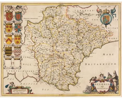
Lot 101
Devon. Blaeu (Johannes), Devonia vulgo Devonshire, Amsterdam, circa 1645, engraved map with contemporary hand-colouring, decorative cartouche and mileage scale, 390 x 505 mm, mounted, framed and glazed, together with Blome (Richard). A Mapp of Devon Shire with its Hundreds, circa 1673, hand-coloured engraved map, some fraying and loss to the upper margin but not affecting the image, 255 x 315 mm, mounted, framed and glazedQty: (2)
![Dighton (Robert). Geography Bewitched! or, a Droll Caricature Map of Scotland [and] Geography Bewitched! or, a Droll Caricatu](https://cdn.globalauctionplatform.com/bbef4553-41d6-4997-bfcd-adc700fe24a2/5605489e-930b-421b-a2b4-adc900f66565/468x382.jpg)
Lot 102
Dighton (Robert). Geography Bewitched! or, a Droll Caricature Map of Scotland [and] Geography Bewitched! or, a Droll Caricature Map of Ireland. This Portrait of Lady Hibernia Hull is humbly dedicated to her Husband the great Mr John Bull, Bowles & Carver, circa 1780 [but later mid-19th-century edition], two uncoloured engraved caricature maps on wove, large margins, slight creasing, each approximately 205 x 175 mm, uniformly framed and glazedQty: (2)
![England & Wales. Coronelli (Vincenzo Maria), Parte settentrionale de Regno d'Inghilterra..., [together with] Parte meridi](https://cdn.globalauctionplatform.com/bbef4553-41d6-4997-bfcd-adc700fe24a2/f24e08f4-a318-439f-a517-adc900f66607/468x382.jpg)
Lot 103
England & Wales. Coronelli (Vincenzo Maria), Parte settentrionale de Regno d'Inghilterra..., [together with] Parte meridionale del regno d'Inghilterra..., circa 1697, uncoloured engraved map on two sheets, not conjoined, inset map of the British Isles displayed on 'a curtain', large cartouche to each map, very slight staining, each map approximately 455 x 600 mm, Italian text on versoQty: (2)
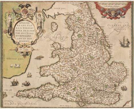
Lot 104
England & Wales. Ortelius (Abraham & Lhuyd Humphrey), Angliae Regni Florentissimi nova descriptio auctore Humfredo Lhuyd Denbygiense [1573 - 84], engraved map with contemporary hand-colouring, large strapwork cartouche and mileage scale, 380 x 470 mm, mounted, framed and glazedQty: (1)Footnote: Marcel Van den Broecke. Ortelius Atlas Maps, no. 19.
![England & Wales. Speed (John), The Kingdome of England, 1st edition, John Sudbury & George Humble [1611], hand-colour](https://cdn.globalauctionplatform.com/bbef4553-41d6-4997-bfcd-adc700fe24a2/30b6fde6-bbe9-4d6a-bde1-adc900f6676d/468x382.jpg)
Lot 105
England & Wales. Speed (John), The Kingdome of England, 1st edition, John Sudbury & George Humble [1611], hand-coloured engraved 'carte-a-figures' map with eight costumed vignettes to the vertical margins, small area of repair at the base of the central fold on the recto, central fold strengthened on the verso, 390 x 515 mm, mounted, framed and double-glazed, English text on versoQty: (1)
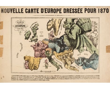
Lot 107
Europe. Hadol (Paul), Nouvelle Carte D' Europe Dressée pour 1870, circa 1870, engraved allegorical map with contemporary hand-colouring, descriptive French text below the image, old folds, several marginal closed tears crudely repaired on the verso, some tape staining to the recto but not affecting the image, 335 x 445 mm, together with Excelsior (publication). La Révolution Chinoise Aggrave le Péril Jaune, 3rd November 1911, black and white printed allegorical map of Europe being the frontispiece of the Excelsior Magazine, 510 x 340 mm, with a music sheet cover of 'The Great Globe. Quadrilles by Stephen Glover', a colour printed circular lithographic map of the Eastern hemisphere, some dust soiling, slight staining, old music publisher's blind stamp to the upper left corner, 345 x 240 mm, plus a pen and watercolour manuscript map on card of ancient Troy, 185 x 140 mmQty: (4)Footnote: The first described item is a satirical and political map of Europe showing the various countries personified in caricature and alludes to the tensions that finally erupted as the Franco-Prussian War in July 1870. This appears to be a variant edition of Hadol's map - possibly a plagiarisation - as there are some slight alterations to the title cartouche and it lacks Hadol's name. The ensuing conflict resulted in France being humiliated, creating a powerful and unified Germany which laid the foundations of both the World Wars in the 20th century. There are later examples of this map with German, English and Dutch text. The second item is an unusual variation on the 'Octopus map' which shows Russia as an aggressive cephalopod whose tentacles reach across Europe. In this case, the danger is shown to be China and Japan and the 'tentacles' are replaced with the overgrown fingernails of Fu Manchu who reaches from over the horizon to engulf Europe.

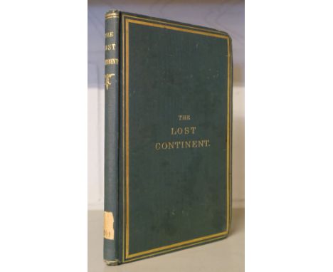
Lot 11
Cooper (Joseph). The Lost Continent; or, Slavery and the Slave-Trade in Africa, 1875. With observations on the Asiatic Slave-trade, carried on under the name of the labour traffic, and some other subjects, 1st edition, London: Longmans, Green, 1875, folding colour map (with short closed marginal tear), advertisement leaf at end, ink stamps of the British Legation, Tehran to title and one other leaf, original cloth gilt, paper shelf number to spine, 8voQty: (1)
![Hungary. Ortelius (Abraham, Hungariae Descriptio, Wolfgang Lazio Auct [1603], uncoloured engraved map, slight staining, 355 x](https://cdn.globalauctionplatform.com/bbef4553-41d6-4997-bfcd-adc700fe24a2/c6286992-414f-4030-82e7-adc900f66daa/468x382.jpg)
Lot 114
Hungary. Ortelius (Abraham, Hungariae Descriptio, Wolfgang Lazio Auct [1603], uncoloured engraved map, slight staining, 355 x 495 mm, Latin text on verso, together with Homann (Johann Baptist). Regnum Borussiae ..., Nuremberg circa 1715, engraved map with contemporary outline colouring, large uncoloured allegorical cartouche, slight staining, 495 x 570 mmQty: (2)Footnote: The first described item: Marcel van den Broecke. Ortelius Atlas Maps, no.150.

Lot 116
Ireland. Speed (John), The Province of Mounster, John Sunbury & George Humble, circa 1627, hand-coloured engraved map, inset town plans of Limerick and Cork, the plan of Cork appears to have been excised from another copy and pasted over the original, slight staining to the central fold, slight worming to the margins, occasional repaired marginal closed tears, 385 x 510 mm, English text on versoQty: (1)

Lot 117
Isle of Man. Collins (Capt. Greenville), The Isle of Man, circa 1700, uncoloured engraved sea chart, inset view of Peel Castle, slight staining to the central fold, 430 x 550 mm, mounted, framed and glazed, together with Mercator (Gerard). Westmorlandia, Lancastria, Cestria, Caernavan, Denbigh..., circa 1610, engraved map of North-east England and the Isle of Man with contemporary outline colouring, large strapwork cartouche, small repair at the base of the central fold, some creasing, two wormholes affecting the image, central fold partially strengthened on verso, 355 x 415 mm, mounted, framed and double-glazed, German text on verso, with Mallet (Alain Manesson). Is. de Man et D'Anglesey, circa 1685, uncoloured engraved map, one closed tear in the margin, 175 x 110 mm, mounted, framed and glazed, plus Blaeu (Johannes). Mona, Amsterdam, circa 1648, engraved map with contemporary hand-colouring, creased, spotted and stained, 385 x 280 mm, mounted, framed and glazed, and Kitchin (Thomas). The Isle of Man Drawn from the Best Authorities, published for The London Magazine and printed by R. Baldwin, circa 1760, uncoloured engraved map, old folds, 220 x 170 mm, mounted, framed and glazed, together with another 8 maps of The Isle of Man and British Islands, including examples by Seller/Grose, Thomsom, Hall, Van den Keere, Lewis, Moule and Johnson, various sizes and condition, all framed and glazedQty: (14)

Lot 118
Isle of Man. Speed (John), The Isle of Man exactly described and into Several Parishes divided..., 1st edition, 1611, hand-coloured engraved map large strapwork cartouche and mileage scales to the vertical margins, slight spotting, thread margins, 380 x 505 mm, mounted framed and double-glazed, English text on versoQty: (1)

Lot 119
Lewis (Samuel). A Topographical Dictionary of England..., 5 volumes (including the atlas volume), together with A Topographical Dictionary of Wales..., 2 volumes, 1844, engraved folding map of England & Wales and 53 engraved maps (including 13 folding) all with contemporary outline colouring, lacking the folding map of London, some spotting throughout, publishers' blind-stamped gilt cloth, some wear to extremities, 4to, together with another uncoloured partially excised volume with 39 uncoloured engraved maps, lacking spine, 4to, with Dugdale (Thomas). Curiosities of Great Britain England & Wales Delineated..., volumes 1 - 4 & 8 (only) circa 1850, 37 engraved maps (only) by J. Archer, all with contemporary outline colouring, numerous uncoloured engraved topographical views, slight spotting, publisher's cloth gilt, worn and rubbed, 8vo, plus Shepherd (Thomas). London and its Environs in the Nineteenth Century..., Jones & Co. 1829, decorative title and 140 engravings (on 70 sheets) on India wove, slight spotting, publisher's half calf, heavily worn and frayed, lacking spine, upper board detached, 8vo, and Curmer (L. editor). Les Français Peints par Eux-Memes, Encyclopedie Morale..., 2 volumes, 1841, additional decorative title, numerous engraved costume plates with contemporary hand-colouring, contemporary half morocco gilt, upper boards detached, one volume with spine partially lacking, heavily worn and rubbed, 8vo, with three early 20th-century folding maps of Warwickshire and an early 20th-century photographic view book of OxfordQty: (20)Footnote: Sold as a collection of maps and prints, not subject to return.
Lot 120
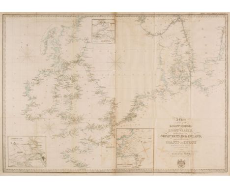
Lighthouses. Laurie (R. H. publisher), A Chart exhibiting the Lighthouses and Light Vessels on the Coasts of Great Britain & Ireland and also those on the Coast of Europe situated between Lat 47º and 59º and Long 6º W to 17º E, published by...., the order of the Honble. Corporation of Trinity House and ordered by the House of Commons to be Printed, 1st August 1845, engraved folding map with contemporary outline colouring, calligraphic title cartouche, three inset maps of Liverpool Bay, The Firths of Forth and Tay [and] The Mouth of the Thames, slight offsetting, short closed tears where old folds cross, ink library stamps on the verso, 725 x 1025 mmQty: (1)Footnote: Scarce. Published as part of a Select Committee report of Lighthouses. We can find no record of this map appearing as a separate publication and no copies are listed in Copac.

Lot 121
Madagascar. Bellin (Jacques Nicolas), Carte de l'Isle de Madagascar dressée au Depost des Cartes, Plans et Journaux de la Marine..., Depot de la Marine, Paris, 1765, hand-coloured engraved map, inset map showing the island in relation to the East-African coast, 'Depot de la Marine' stamp to the lower right corner, very slight staining, 550 x 885 mm, mounted, framed and glazed, together with a presentation plaque celebrating the retirement of the British Ambassador to Madagascar in 1990Qty: (2)
Lot 122
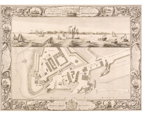
Manchester. Laurent (C. surveyor), A Topographical Plan of Manchester and Salford, with the Adjacent Parts shewing also the Different Allotments of Land proposed to be built on, John Stockdale, 1793, uncoloured engraved map on four conjoined sheets, three inset maps of the county around Manchester, Manchester in 1650 and the Road from Manchester to London, old folds, 1040 x 935 mm, together with Milton (Thomas). A Geometrical plan & West elevation of His Majesty's Dock-yard and Garrison at Sheerness with the Ordnance Wharfe &c., 1755, uncoloured engraved map with a panorama of the dockyard above the plan, engraved by J. Cleveley and P. C. Canot after T. Milton, decorative borders, old folds, upper margin extended, 480 x 650 mm, with Stanford G. publisher). Plan of the Borough of Hammersmith, 1942, uncoloured lithographic map, old folds,1000 x 685 mm, plus Chapman & Hall (publisher). The Stars in Six Maps on the Gnomonic Projection Revised by W. R. Dawe under the Superintendence of the Society for the Diffusion of Useful Knowledge, 1844, title and explanation and six engraved celestial maps with contemporary outline colouring, each map 310 x 280 mm, disbound,Qty: (4)

Lot 126
North America. Buchon (Jean Alexandre), A collection of eight maps of North American States, Carte Géographique, Statistique et Historique du..., New Hampshire, Vermont, Delaware, Ohio, Pennsylvania, Maine, New Jersey [and] Rhode Island, Paris, circa 1825, double-page engraved maps with contemporary hand-colouring, French text below and to the sides of each map, each approximately 470 x 610 mmQty: (8)Footnote: Originally published in 'Atlas Geographique, Statistique, Historique et Chronologique...,' a French edition of earlier maps by Cary & Lea published in "A Complete Historical, Chronicle, and Geographical American Atlas". The descriptive text surrounding the maps describes the history, rivers, climate, religion, principal towns and government officials of each state.

Lot 127
North America. Kitchin (Thomas), Mexico or New Spain in which the Motions of Cortes may be Traced..., W. Strahan & T. Cadell, 1793, uncoloured engraved map, inset map of the Environs of Mexico, old folds, thread margin on the right-hand vertical border, 290 x 380 mm, together with Robinson (G. G. & J. publishers). Chart of the North West Coast of America explored by the Boussole & Astrolabe in 1786, Novr. 1st 1798, uncoloured engraved chart (showing San Francisco) old folds, slight creasing and staining, 390 x 495 mm, with Lodge (J.). A Map of Mexico or New Spain from the Latest Authorities, J. Bew, 1782, uncoloured engraved map, old folds, slight staining, 285 x 370 mm, with another copy similar, plus Betts (John). United States, Canada & New Brunswick, circa 1860, lithographic map with contemporary outline colouring, 360 x 420 mm, and Barker (W.). The State of New Jersey Compiled from the most Authentic Information [and] The State of Pennsylvania Reduced with Permission from Reading Howell's Map by Samuel Lewis, Carey's American Edition of Guthrie's Geography Improved, circa 1795, two uncoloured engraved maps, old folds, slight staining, each approximately 485 x 320 mm, with others similar, including examples by or after Kitchin, J & C Walker, Boynton, Lizars, Hall, Stockdale, Oddy, Cram (publisher) and Colton, various sizes and conditionQty: (31)


Lot 132
Poland. Munster (Sebastian), Polonia et Ungaria XV Nova Tabula, circa 1550, uncoloured woodblock map of Poland, Lithuania, Moscovy and the Balkans, extending as far south as Constantinople, 275 x 350 mm, together with two slightly later examples (one with hand-colouring), all mounted, framed and glazedQty: (3)

Lot 133
Prussia. Sotzmann (Daniel F.), Topographische Militarische Karte Nee Ostpreussen der dem jetzigen Nördlichen Theil des Herzogthums Warschau nebst dem Russischem District, Berlin, 1808, monumental engraved map with contemporary outline colouring, printed on 30 sheets, conjoined to form three maps, old folds, each map tipped on to later card, overall size approximately 2360 x 2320 mm, each map framed and glazedQty: (3)
![Saxton (Christopher & Hole G. & Kip W.). A collection of 13 maps, [1607 - 37], hand-coloured engraved maps, each appr](https://cdn.globalauctionplatform.com/bbef4553-41d6-4997-bfcd-adc700fe24a2/667d1973-c11f-46ea-a008-adc900f67c3c/468x382.jpg)
Lot 134
Saxton (Christopher & Hole G. & Kip W.). A collection of 13 maps, [1607 - 37], hand-coloured engraved maps, each approximately 260 x 305 mm, one map with Latin text on the verso (Somerset), the remainder blank, various conditionQty: (13)Footnote: The maps comprise of - Somerset, Cheshire, Worcestershire, Herefordshire, Cumberland, Berkshire, Bedfordshire, Northamptonshire, Denbigh, Merioneth, Brecknock, Radnor and Montgomery

Lot 135
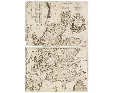
Scandinavia. Ruscelli (Girolamo), Schonladia Nuova, Venice, 1598, uncoloured engraved map on a trapezoidal projection, slight staining to the margins but not affecting the image, 190 x 260 mm, Italian text on verso, together with Gastaldi (Giacomo). Tabula Europae VIII, Venice, circa 1548, hand-coloured engraved map on a trapezoidal projection, 130 x 175 mm, Latin text on versoQty: (2)Footnote: The first described map is the third state, identifiable by the addition of the sea monster. Originally published in 'La Geografia di Claudio Tolomeo Alessandrino'. The large island of Thyle situated above the British Isles is a geographical misrepresentation (both in size, shape and geographical positioning) of Iceland.
Lot 136
Scotland. Coronelli (Vincenzo Maria), Scotia Parte Settentrionale..., & Scotia Parte Meridionale..., Venice, circa 1700, two sheet uncoloured engraved map, not conjoined, each with an elaborate cartouche and mileage scale, old folds, narrow margins, slight staining, each sheet approximately 450 x 625 mm, together with 6 sheets from the same publication including an engraved coat of arms, a small map of Scotland, a view and a plan of Edinburgh, sheet size 190 x 270 mm, with Van den Keere (Pieter). The Kingdome of Scotland, circa 1627, uncoloured engraved miniature map, slight water staining, 85 x 125 mm, English text on verso, together with another late 18th-century map of Scotland with contemporary outline colouring, engraved for 'Walker's Geography, 190 x 220 mmQty: (10)

Lot 137
Sea Chart. Van Keulen (G.), A New Enereasing Compass Map of the East-Coast of England; Extending from Eckles to Flamborough-Head containing the River of Hull with their Shallonesses and Depths by Claas de Vries Geometra, Amsterdam, circa 1760, uncoloured engraved sea chart, title repeated in Dutch, compass rose and numerous rhumb lines, 525 x 590 mmQty: (1)


Lot 139
Somerset. Speed (John), Somerset-Shire Described and into Hundreds divided with the plot of the famous and most wholsom waters and citie of the Bathe, 1st edition, John Sudbury and George Humble [1611], hand-coloured engraved map, inset town plan of Bath, one small repaired tear to the central fold, the fold strengthened on the verso 385 x 515 mm, framed and double-glazed, English text to versoQty: (1)
Lot 140
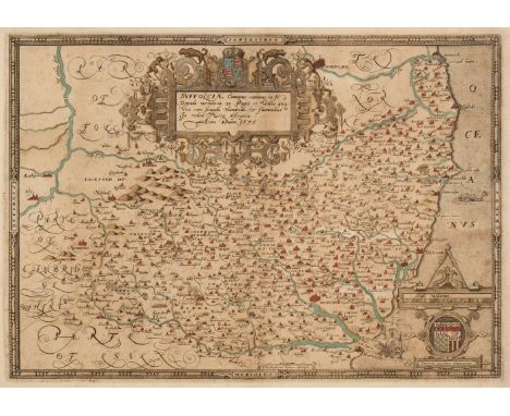
Suffolk. Saxton (Christopher), Suffolciae Comitatus continens in Se oppida Mercatoria 25 Pagos et Villas 464 una cum singulis hundredis et fluminibus in eodem vera descriptio, [1579], engraved map with contemporary hand colouring and some later enhancement, slight spotting, large strapwork cartouche and mileage scale, laid on later paper, 340 x 485 mmQty: (1)Footnote: The first printed map of Suffolk with the 'bunch of grapes' watermark.
![Surrey. (Bill (John), Surrey, [1626], uncoloured engraved map, large margins, 90 x 120 mm, English text on the versoQty: (1)F](https://cdn.globalauctionplatform.com/bbef4553-41d6-4997-bfcd-adc700fe24a2/1b6e478f-8f92-4b1f-a372-adc900f682cf/468x382.jpg)

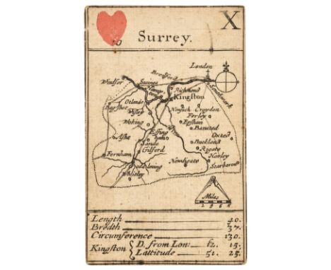
Lot 143
Surrey. A collection of 10 maps, 17th & 18th century, engraved maps, seven with hand-colouring, including Simmons (Matthew). Surrey, [1643], hand-coloured engraved miniature map and mileage triangle, English text below and on the verso, map size 105 x 105 mm, with another uncoloured example, together with Gibson (John). Surry (sic), [1759], engraved miniature map with contemporary outline colouring, slight marginal staining, 65 x 115 mm, with Blome (Richard). A Mapp of Surrey, circa 1681, hand-coloured engraved map, 150 x 210 mm, plus Bowles & Carver (publisher). Bowles's New Medium Map of Surrey, Divided into Hundreds..., circa 1785, engraved map with contemporary outline colouring, slight dust soiling and some adhesion scarring to the verso, 230 x 330 mm, and Morden (Robert). Surrey, circa 1701, hand-coloured engraved map, 175 x 210 mm, supplied with the triangular mileage table, with another four county maps by Emanuel Bowen, John Seller, Thomas Kitchin and Kitchin/Jefferies, various sizes, good conditionQty: (10)
Lot 147
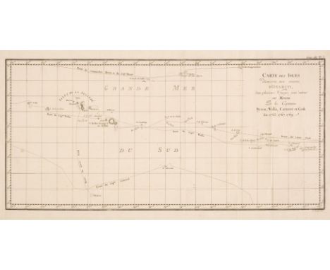
Tahiti & South Sea Islands. Cook (James), Carte de L'Isle D'Otahiti par le Lieutenant J. Cook, 1774, uncoloured engraved map, some staining and offsetting, old folds, 240 x 410 mm, together with Carte des isles découvertes aux environs D'Otahiti dans plusiers Voyages faits autour du Monde par les Capitaines Byron, Wallis, Carteret et Cook en 1765, 1767, 1769, circa 1774, uncoloured engraved map, old folds, 250 x 515 mm, with Neele (Samuel). Plan of Cook's Bay [with inset map] Plan of Easter Island taken in April 1786, G. G. & J. Robinson, 1798, two uncoloured engraved maps and four horizon profiles on one sheet (as published), slight staining, 390 x 500 mm, together with Débarquement à Tanna l'une des Nouvelles Hébrides, Vue D'Anamooka & Débarquement à Middleburgh l'ine des Isles Friendly (Des Amis), circa 1774, together three uncoloured engravings old folds, each approximately 225 x 470 mm, with La Perouse (Jan Francois de Galaup). Massacre de MM. de Langle , Lamanon et de dix autres individus des deux Equipages, [1797], uncoloured engraving, slight spotting and staining to the margins, 290 x 420 mm, plus Benoist (Phillipe). Vue de la Baie D'Umata (Ile de Guam), circa 1860, uncoloured lithograph after De Saison, 270 x 360 mm, and two further engravings of South Sea native artefacts and and sheet of horizon profiles of the Sandwich Islands, various sizes and conditionQty: (10)

Lot 150
Wales. Blaeu (Johannes), Five county maps, Ceretica sive Cardiganensis Comitatus Anglis Cardigan Shire, Denbigiensis Comitatus et Comitatus Flintensis Denbigh et Flintshire, Radnoria Comitatus Radnor Shire, Comitatus Caernarvoniensis vernacule Carnarvon-shire et Mona Insula vulgo Anglesey, with another uncoloured example, Amsterdam, circa 1645, five engraved maps, four with contemporary hand-colouring, each approximately 385 x 500 mm, the coloured examples with French text on the verso, the uncoloured map with Dutch text on the versoQty: (5)

Lot 152
Wales. Ortelius (Abraham & Lhuyd Humphrey), Cambriae Typus Auctore Humfredo Lhuydo Denbigiense Cambrobritano [1584 or later], engraved map with sparse contemporary hand-colouring, slight mottling to the map, 370 x 495 mm, mounted, framed and glazedQty: (1)Footnote: Marcel van den Broecke. Ortelius Atlas Maps, no. 21.


Lot 155
Wales. Speed (John), Wales, John Sudbury & George Humble, circa 1627, hand-coloured engraved map, inset views of Bangor, St Asaph, S. Davids and Llandaff, with 12 oval vignettes of principal Welsh cities and towns to the vertical margins, very slight creasing, very slight spotting to the margins, 385 x 505 mm, mounted, framed and glazedQty: (1)


Lot 158
Warwickshire. Speed (John), The Counti of Warwick. The Shire Towne and City of Coventre described, Thomas Bassett & Richard Chiswell [1676], hand-coloured engraved map, inset town plans of Warwick and Coventry, good margins, slight spotting, 385 x 510 mm, framed and glazed, together with Shropshire. Speed (John), Shropshyre described. The Sittuation of Shrowesbury shewed with the Armes of those Earles and other memorable things observed, George Humble, circa 1627, uncoloured engraved map, an inset town plan of Shrewsbury, some toning and staining, 385 x 515 mm, mounted, framed and glazedQty: (2)

Lot 159
West Wales. Saxton (Christopher & Lea Philip), Radnor, Breknoke, Cardigan and Carmarthen Shires, Discribed by C. S. Corrected and Amended with many Additions by P. Lea [1689], engraved map with contemporary outline colouring, inset town plans of Carmarthen, Brecknock, Radnor and Cardigan, 370 x 480 mm, mounted, framed and glazedQty: (1)

Lot 160
Wiltshire. Blaeu (Johannes), Wiltonia sive comitatus Wiltoniensis, Anglis Wilshire, Amsterdam, circa 1645, engraved map with contemporary hand-colouring, slight creasing, 415 x 500 mm, framed and double-glazed, French text on the verso, together with Ducatus Eboracensis pars Orientalis, The East Riding of Yorkeshire, Amsterdam, circa 1645, engraved map with contemporary hand-colouring, slight overall toning, slight worming but confined to the margins, 380 x 510 mm, framed and glazedQty: (2)

Lot 161
World. Bowen (Emanuel), A New & Accurate Map of all the Known World..., circa 1740, hand-coloured engraved map, old folds, slight dust soiling, folds partially strengthened on verso, 310 x 525 mm, together with Bowen (Thomas). The World including the late Discoveries by Capt. Cook and other Circumnavigators..., circa 1770, hand-coloured engraved map, old folds, slight spotting, 285 x 460 mm, with Laurie (Robert & Whittle James). The New World or Western Hemisphere, The Old World or Eastern Hemisphere [and] South Pole from the Tropic of Capricorn, 1st Octr. 1801, together three circular maps with bright contemporary hand-colouring, each approximately 210 x 260 mm, plus Betts (John). The London Series of Modern Maps. The Western hemisphere [and] The Eastern Hemisphere, circa 1860, a pair of circular lithographic projections of the world with contemporary hand-colouring and decorative margins, slight dust soiling and spotting, each approximately 450 x 360 mm, with another five maps of the world on a Mercator and hemispheral projection, including examples by Conder, Thomson, Dilly & Robinson and Miller, various sizes and conditionQty: (12)

Lot 162
World. Conder (Thomas), An Accurate Map of the World, Comprehending All the Discoveries in Both Hemispheres Carefully Drawn from the Best Authorities, circa 1780, hand-coloured engraved map on a hemispheral projection, old folds, slight dust soiling, 300 x 465 mm, together with Chamouin (Jean Baptiste Marie). Mappe-Mondes sur Diverses Projections, Paris, circa 1808, engraved map of the world with contemporary outline colouring on a hemispheral projection, decorative title cartouche and five additional globes of poles and hemispheres to the margins, 330 x 480 mm, with De Lat (Jan). De Zuid Pool waar in aangetoont were able de Nieuwe Landen tot op heden toe ontdekt..., circa 1750, hand-coloured engraved map of the South Pole, two small inset maps of Cape Circoncision (a peninsula on the north-western edge of subantarctic Bouvetoya) and the Solomon Islands, old folds, 180 x 275 mm, plus Dilly (C. & Robinson G. publishers). A Map of the World from the best Authorities, 1785, engraved map with contemporary outline colouring, slight offsetting, old folds, 295 x 545 mm, and Bowen (Emanuel). A New & Accurate Chart of the World Drawn from Authentic Surveys..., circa 1730, hand-coloured engraved map on Mercator's projection, 370 x 445 mm, with Bayly (J.). A Map of the World with the Latest Discoveries by the Revd. John Blair..., 1779, uncoloured engraved map on a hemispheral projection, old folds, 425 x 710 mm, with another ten engraved maps of the world, including examples by Conder, Ailman, Constable (publisher), Arrowsmith, Baker and Bowen, various sizes and conditionQty: (16)
![World. Moxon (Joseph), A Map of all the World and how after the Flood it was Divided among the Sons of Noah [1671 or later],](https://cdn.globalauctionplatform.com/bbef4553-41d6-4997-bfcd-adc700fe24a2/f3feaf22-1114-4966-8df2-adc900f69382/468x382.jpg)
Lot 163
World. Moxon (Joseph), A Map of all the World and how after the Flood it was Divided among the Sons of Noah [1671 or later], uncoloured engraved map, California as an island, the map surrounded by twelve biblical vignettes, old folds, some staining, slight marginal fraying, 325 x 455 mmQty: (1)Footnote: R. W. Shirley, The Mapping of the World, no. 457. A 'bible map' dedicated to Gilbert Sheldon, Archbishop of Canterbury.
![World. Ruscelli (Girolamo), Orbis Descriptio, Venice [1561], hand-coloured engraved map, very slight spotting, some finger so](https://cdn.globalauctionplatform.com/bbef4553-41d6-4997-bfcd-adc700fe24a2/473049c4-7de1-4725-9b34-adc900f69491/468x382.jpg)
Lot 164
World. Ruscelli (Girolamo), Orbis Descriptio, Venice [1561], hand-coloured engraved map, very slight spotting, some finger soiling and slight creasing to the margins, 200 x 260 mm, Latin text on versoQty: (1)Footnote: This is the first hemispheral map of the world to appear in an atlas. Based on Gastaldi's map it shows a landmass joining Asia to North America, and there is no southern continent (although this was amended on later editions). R. W. Shirley. The Mapping of the World, no. 110.
Lot 20
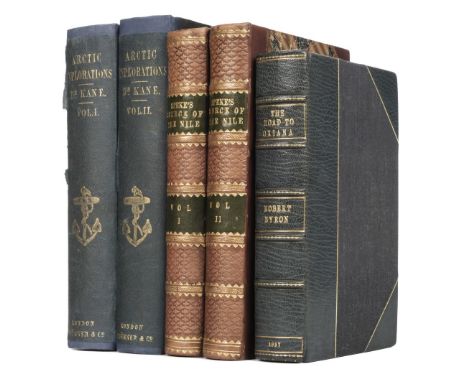
Kane (Elisha Kent). Arctic Explorations: The Second Grinnell Expedition in search of Sir John Franklin, 1853, '54, '55, 2 volumes, 2nd edition, Philadelphia & London, 1857, portraitr frontispieces, additional engraved titles, 18 plates, 2 folding maps (one detached), single page map, p.75 in volume I with long closed tear, some spotting and light soiling, cut signature of Henry Grinnell pasted to volume I additional title verso, volume I endpapers replaced, original blue cloth, rebacked with original spines relaid, small split to volume I lower joint, a little rubbed and stained, 8vo, together with Speke (John Hanning). Journal of Discovery of the Source of the Nile, 2 volumes, 2nd edition, Edinburgh & London: William Blackwood, 1864, large folding map, wood-engraved plates and illustrations, volume II lacking title, a little light spotting and toning, modern half calf gilt, 8vo, plus Byron (Robert). The Road to Oxiana, 1st edition, London: Macmillan & Co., 1937, half title,16 half-tone plates, 5 maps, advertisement leaf, modern blue half morocco gilt, 8voQty: (5)
Lot 201
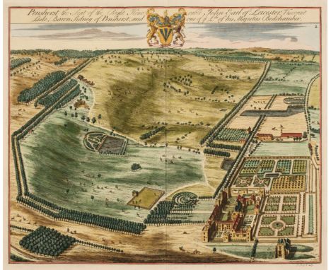
Kent. Kip (J. & Harris J.), Six aerial prospects of country estates, Penshurst the seat of the Right Honorable John Earl of Leicester..., (2 copies), Squerries at Westram in Kent, Chepsted Place one of ye Seats of David Polhill Esqr. The Seat of Pendock Price Esqr. at Westram [and] Sunbridge Place, Bore Place & Sharps Place, the Seats of John Hyde Esq. originally published in Dr Harris's 'History of Kent...', circa 1728, six engraved aerial prospects, two with later hand-colouring, each approximately 350 x 420 mm, together with Hassell (J.). Belvidere House Kent, the seat of Lord Earley, Westerham - Kent, Riverhead - Kent, Hever Castle - Kent, Tunbridge - Kent & Foots Cray - Kent, 1818, six miniature aquatints with contemporary hand-colouring, each approximately 75 x 95 mm, with Hasted (Edward). A Map of Westerham & Eaton Bridge Hundred with the Parish and Ville of Brasted and the Hundred of Somerden, [1778], hand-coloured engraved map, two marginal repaired closed tears, 395 x 390 mm, with Andrews (John & Dury Andrew). Large scale map of Kent, Sheets 6 and 11 only [1769], two double-page engraved maps of parts of Kent, each with contemporary outline colouring, each approximately 480 x 670 mmQty: (15)
Lot 21
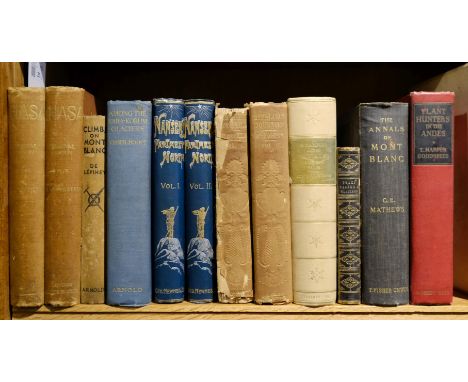
Landon (Perceval). Lhasa, an account of the country and people of Central Tibet..., 2 volumes, 1st edition, London: Hurst and Blackett, 1905, numerous monochrome illustrations, bookplates to the front pastedowns, front endpaper & colour folding map to volume 1 detached, guttering cracked, some light toning & spotting throughout, top edges gilt, publishers original uniform gilt decorated red cloth, boards & sines slightly faded & rubbed, 8vo, together with; Nansen (Fridtjof), "Farthest North"..., 2 volumes, London: George Newnes, 1898, colour folding map to the rear of volume 1, numerous monochrome illustrations, some minor toning, publishers original uniform gilt decorated & illustrated green cloth, minor rubbing to boards & spines, 8vo, plus Hooker (Joseph Dalton), Himalayan Journals; or, notes of a naturalist, 2 volumes, London: John Murray, 1854, black & white illustrations, period inscriptions to both half-titles, later presentation bookplates to the front endpapers, some spotting & light toning, gutters cracked, publishers original gilt decorated embossed plum cloth, boards rubbed & slightly marked, spines faded & rubbed with loss, 8vo, and 6 further volumes of late 19th & early 20th-century mountaineering & travel reference, including Scrambles Amongst The Alps In The Years 1860-69, by Edward Whymper, 4th edition, London: John Murray, 1893, 8vo, Peaks, Passes, and Glaciers, edited by John Ball, 5th edition, London: Longman, Green, Longman, & Roberts, 1860, 8vo, Among the Kara-Korum Glaciers in 1925, by Jenny Visser-Hooft, 1sted edition, London: Edward Arnold, 1926, 8voQty: (12)
![Bible [English]. [The Holy Bible, containing the Old Testament, and the New: newly translated out of the originall tongues...](https://cdn.globalauctionplatform.com/bbef4553-41d6-4997-bfcd-adc700fe24a2/ea7c7e99-f2e2-46db-beb1-adc900f6d435/468x382.jpg)
Lot 254
Bible [English]. [The Holy Bible, containing the Old Testament, and the New: newly translated out of the originall tongues..., Imprinted at London: by Bonham Norton, and John Bill, 1628], without general title, New Testament title present within decorative woodcut border (faint early inscription to verso), Apocrypha present, few woodcut decorative ornament line fillers between various books of the Bible, colophon to recto of final leaf (3K8a) with woodcut tailpiece, C7 & C8 torn with loss to lower quarter, 2Y5 slightly torn to fore-margin with minor loss to letterpress marginal notes, leaf 3B5 torn with loss to right half of leaf, cropping to running titles at head, bound with the Genealogies by John Speed (without map of Holy Land), and also bound with an incomplete Common Prayer at front of volume, bound with at rear Pagit (Eusebius), The Historie of the Bible, briefely collected by way of question and answer, London: John Legatt, 1627, leaf C4 torn at foot with loss, some dust-soiling & few marks throughout, occasional light damp staining, front blank flyleaf inscribed 'Thomas Wightwick his book April 14th 1806', rear blank flyleaf with early 19th century genealogical entries for the Wightwick family, late 18th century calf, surface rubbed and worn, 8vo (15.6 x 10.8 cm)Qty: (1)Footnote: Herbert 412; Darlow & Moule 316; STC 2282. Fry enumerates five distinct editions of this date. Some of his copies may be mixed (Herbert, Darlow & Moule). This volume appears to be edition 'A', which has ornaments before Isaiah and Mark consisting of grotesque animals.
Lot 30
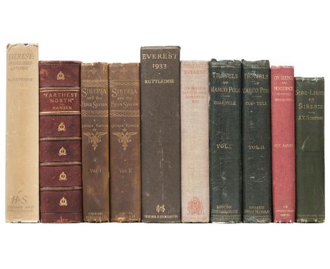
Ruttledge (Hugh). Everest: The Unfinished Adventure, 1st edition, Hodder & Stoughton, 1937, gift inscription to front free endpaper, 2 folding maps, illustrations to rear, original cloth, dust-jacket, panels spotted, spine toned, extremities worn, 4to, together with: Nansen (Fridtjof). Farthest North, 1st edition in English, 2 volumes in 1, London: George Newnes, Ltd, 1898, frontispieces, folding map to rear, numerous illustrations, occasional light spotting, hinges cracked, red half morocco, joints rubbed, backstrip detaching, 4to, together with 7 other volumes of travel & mountaineeringQty: (9)
Lot 308
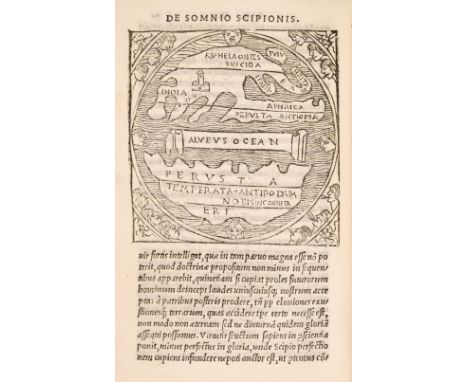
Macrobius (Ambrosius Aurelius Theodosius). Hoc volumine continentur. Macrobii Interpretatio in Somnium Scipionis a Cicerone confictum. Eiusdem Saturnaliorum libri septem, [Florence: Filippo Giunta, July 1515], italic text, 6 woodcut illustrations (including a world map), final leaf with woodcut printer’s device verso, occasional light water stains, inscription erased from head of title, typescript booklabel of William Friskney, ownership signature of D.L. Cumming, later vellum, spine gilt in compartments with morocco label, some light soiling, 8voQty: (1)Footnote: Adams M59; Grasse IV, 330; Shirley 13 (for the 1483 edition). Provenance: "Wm. Nance, bought at Dr Harington's sale - Jan. 1813", inscription at front. "The works of Macrobius, a fifth-century AD Roman philosopher, were of great popularity throughout the Middle Ages. His neoplatonic commentary on Cicero includes, among many references to the pseudo-sciences, a geographic concept which is different from that of Ptolemy. The inhabited world north of the Equator is balanced by a southern continent and divided from it by water." (Shirley).
Lot 309
Manton (Thomas). A Practical Commentary, or an Exposition with notes on the Epistle of James. Delivered in sundry weekly lectures at Stoke-Newington in Middlesex, neer London, London: printed by J. Macock for Luke Fawne, 1651, title within typographic border and with early signature J. Hotchkis, some marginal browning, light dust-soiling and few marks, contemporary calf, old repairs to joints, upper board detached, rubbed and worn, 4to, together with: Jane (William), A Sermon preached on the day of the Publick Fast, April the 11th 1679 at St. Margarets Westminster; before the honourable House of Commons, London: printed by M.C. for Henry Brome & Richard Chiswel, 1679, imprimatur leaf present, bound with, Scott (John), A Sermon preached at the Assizes at Chelmsford, in the County of Essex, August 31, 1685, before the honourable Sir Thomas Street, Kt. one of the Judges of his Majesty's Court of Common Please, London: printed by M. Flesher for Rob. Horn & Walter Kettilby, 1686, and bound with five other similar pamphlets, each pamphlet badly damp-frayed & stained at fore-edge, contained within contemporary calf boards (volume raided with other pamphlets previously removed), old reback, 4to, Guarini (Battista), Il Pastor Fido, The faithfull Shepherd. A Pastorall written in Italian ... and now newly translated out of the original, London: printed by R. Raworth, 1647, one engraved plate only (lacking frontispiece), free endpapers torn away, contemporary mottled sheep, later maroon morocco title label to spine, upper joint cracked at head, extremities rubbed, 4to, and two others, Ambulator; or, the Stranger's companion in a tour round London..., 3rd edition, London: J. Bew, 1787, folding engraved map frontispiece, contemporary sheep, joints cracked, extremities rubbed, 12mo, and Barrow (Isaac), Opuscula; viz. Determinationes, conc. ad Clerum, Orationes, Poemata, & &c., volume 4 only (of 4), London: Brabazon Aylmer, 1687, engraved portrait frontispiece, title in red & black, contemporary calf, red morocco title label to spine, joints split, folioQty: (5)
Lot 31
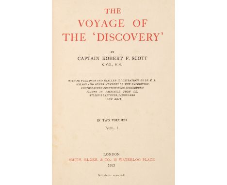
Scott (Robert Falcon). The Voyage of the Discovery, 1st edition, London: Smith, Elder & Co, 1905, frontispieces, 12 colour plates, numerous black & white photographic plates, 5 maps (two folding housed in rear pockets), some light marginal spotting, original publisher's cloth, gilt vignettes to front boards, spines faded, chipped to extremities, boards rubbed & marked (volume 2 rear board soiled), rear joint of volume 1 splitting, small portions of soiling to volume 2 backstrip, 8vo, together with: Ross (Sir John). Narrative of a Second Voyage in Search of a North-West Passage, 1st edition, London: A.W. Webster, 1835, volume 1 only (lacking appendix), 4 maps, lacks large folding map,16 engraved plates, 6 lithographs and 3 hand-coloured mezzotints, damp-staining throughout, ownership inscription to front free endpaper, original cloth boards, rebacked preserving some of original spine, 4to, plus 8 other volumes of polar explorationQty: (12)
Lot 315
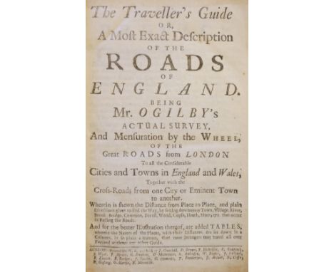
Ogilby (John). The Traveller’s Guide or, a most exact description of the roads of England. Being Mr. Ogilby’s actual survey, And Mensuration by the Wheel, of the great roads from London to all the considerable cities and towns in England and Wales, Together with the cross-roads from one city or eminent town to another..., London: W[illiam]. B[ray]., [1712], one folding engraved map trimmed to left margin and browning to fold, woodcut headpiece to B1 trimmed to right-hand border, title to Tables with imprint dated 1712, contemporary panelled calf, joints lightly cracked, 8vo, together with: Callcott (John Wall), A Musical Grammar, in four parts: I. notation, II. melody, III. harmony, IV. rhythm, London: printed by S. Macmillan for Robert Birchall, 1806, musical notation to text, occasional annotations to index and rear endpaper, leaves 2C3 & 2C4 sprung, contemporary diced calf, gilt decorated spine without title label, 8vo, Marie Antoinette, The Trial at large of Marie Antoinette, late Queen of France, before the Revolutionary Tribunal, at Paris, Oct. 15, and an authentic account of her execution, October 16, 1793, 3rd edition, London: J. Ridgway, 1793, light dust-soiling and scattered spotting, 19th century half calf, slim 8voQty: (3)
Lot 32
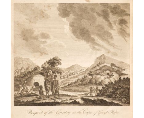
Sparrman (Anders). A Voyage to the Cape of Good Hope, towards the Antarctic Polar Circle, and Round the World, but chiefly into the Country of the Hottentots and Caffres, from the year 1772 to 1776, 1st edition in English, London: Printed for G.G.J. and J. Robinson, 1785, frontispiece, 9 engraved plates, folding map, small library stamp & notations to titles, folding map torn, occasional spotting, hinges cracked, contemporary calf, front board of volume 2 detached, both volumes lacking head & tailcaps, joints cracked, boards marked, extremities worn, 4toQty: (2)Footnote: Mendelssohn IV p. 362. Translated from the Swedish edition. The first edition in English contains an additional plate, 'Dwarf-Mice'.
Lot 37
Wilson (James). A Missionary Voyage to the Southern Pacific Ocean, performed in the Years 1796, 1797, 1798, in the Ship Duff, commander by Captain James Wilson ... icnlduing Details never before published, of the Natural and Civil State of Otaheite, 1st edition, London: by S. Gosnell, for T. Chapman, 1799, 13 engraved maps and plates (a few folding), light offsetting, General Map spotted, a few spots to other plates or maps, General Map and Feejee Islands map each with retrievable paper-disruption to central intersection of folds, engraved bookplate (Arthur Kelly, Kelly), contemporary marbled calf, rebacked with original spine laid down, 4to (28.9 x 22.2 cm)Qty: (1)Footnote: Borba de Moraes II pp. 378-9; ESTC T87461; Ferguson 301; cf. Sabin 49490 (for the 'ordinary' edition). The preferred Gosnell edition: there was also an 'ordinary' edition (Ferguson) with the imprint 'for T. Chapman ... by T. Gillet', in a completely different setting and on smaller paper; Gosnell's edition is thought to have priority. Borba de Moraes is mistaken in citing a second edition 'similar in all details [to Gosnell's edition] except for the signature of the plates', that is, with 'J. Landseer direxit' rather than 'for Missionary Voyage': it is in fact Gosnell's edition in which the plates have 'J. Landseer direxit'. 'The Duff was the first missionary vessel to sail the little-known waters of the Pacific Ocean. After 208 days the vessel reached Tahiti, landing seventeen missionaries there, a further twelve at Tonga, and one on the Marquesas ... Several of the missionaries settled in Australia and founded families important in Australian history. The Duff proceeded from Tonga through the Fiji and Caroline Groups to Canton. In the course of this voyage the Duff Group was discovered and named and the knowledge of Pacific geography considerably extended' (Ferguson).
Lot 39
Camden (William). Britannia, sive florentiss. regnorum Angliae, Scotiae, Hiberniae, insularumq adiacentium ex intima antiquitate descriptio, Amsterdam: Guilielmum Blaeu, 1639, letterpress title with annotation to upper blank margin and map list to verso (margins frayed), nineteen uncoloured engraved folding regional maps by P. Bertius (16 called for, includes additional maps Anglia; Westmorland, Lancastria, Cestria; and Connata), few maps with manuscript notes to verso, occasional manuscript annotations to text, sewing broken and many leaves detached, contemporary dark brown sheep, covers detached and lower board separated, upper joint cracked, worn, 12moQty: (1)Footnote: Chubb LV. The maps, which are plain at the back, are similar in design and execution to those of Pieter van den Keere of 1599 and were perhaps engraved by him (Chubb). Sold as a collection of maps.
Lot 391
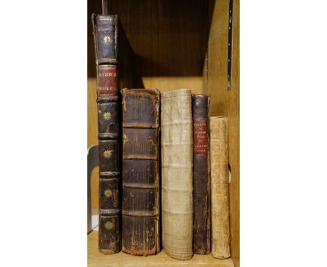
Willis (Robert). Principles of Mechanism, designed for the Use of Students in the Universities, and for Engineering Students Generally, 1st edition, John W. Parker, 1841, wood engravings to text, some spotting or browning, 19th-century prize blue polished calf with gilt arms of Blackheath Proprietary School to upper cover, hinges rubbed and chipped, together with: Blair (Robert), Scientific Aphorisms, Being the Outline of an Attempt to Establish Fixed Principles of Science... , 1st edition, Edinburgh: Adam Black & Longman, 1827, 5 folding plates, modern quarter calf gilt with spine label, plus Sharp (John & Tait, Peter Guthrie & Adams-Reilly, A.), Life and Letters of James David Forbes, FRS, 1st edition, Macmillan, 1873, portrait frontispiece, folding map, plus 2 further portrait plates and 4 photographic illustrations laid in, contemporary calf gilt with gilt-decorated spine and spine label, rubbed, plus: Liebig (Justus), Animal Chemistry, or Chemistry in its Application to Physiology and Pathology... , 2nd edition, Taylor & Walton, 1843, tables in text, contemporary half calf over marbled boards, slightly rubbed, all 8vo, plus other miscellaneous 19th-century science interest including some pamphlets and 4 others leather-boundQty: (28)
-
109182 item(s)/page