We found 109182 price guide item(s) matching your search
There are 109182 lots that match your search criteria. Subscribe now to get instant access to the full price guide service.
Click here to subscribe- List
- Grid
-
109182 item(s)/page


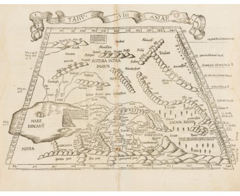
Lot 10
Asia.- Caspian Sea.- Fries (Lorenz) Tabula VII Asiae, Ptolemaic map of Central Asia, woodcut on laid paper with watermark of an encircled anchor with heart [cf. Briquet 585, datable to 1530s and earlier], sheet 380 x 470 mm. (15 x 18 1/2 in), Latin text verso with woodcut border decorations, central vertical fold with early manuscript stub verso, fold with minor discolouration, surface dirt and finger-soiling, small damp-stain in the the left and right borders, not affecting the map, handling creases, unframed, [Strasbourg, 1535].
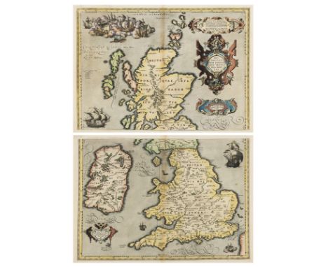
Lot 102
British Isles.- Ortelius (Abraham) Britannicarum Insularum Vetus Descriptio, two-sheet map of ancient Britain, probably engraved by Jan Wierix, with four ornate strap-work cartouches, a naval battle in the upper left, and a number of other vessels around the coast, engravings on laid paper, both with crossed arrow watermarks, richly hand-coloured, un-joined, each platemark approx. 370 x 490 mm. (14 1/2 x 19 1/4 in), sheets approx. 420 x 540 mm. (16 1/2 x 21 1/4 in), Latin text verso, central vertical folds, minor handling creases and surface dirt, unframed, [Antwerp, 1590] (2).Literature:VdB 190-191⁂ This two-part map only appeared in the early editions, being replaced by a single plate in 1595.

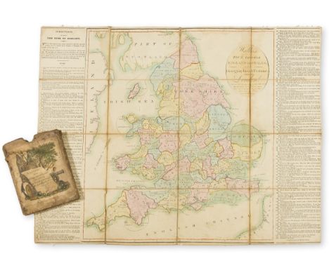
Lot 104
NO RESERVE British Isles.- Lewis (Samuel) A Topographical Dictionary of England, Atlas volume only, title, with 44 maps, of which 14 are folding, later cloth, rubbed and worn, 4to, S. Lewis & Co., 1831 § Cary (John) A New Map of England, folding map, engraving with hand-colouring, 585 x 505 mm. (23 x 19 7/8 in), dissected and mounted on linen, various pencil annotations and doodles throughout, folding into early slip-case, very worn with some splitting, 8vo, 1809 § Hall (Sidney) Scotland, folding "pocket" map with inset map of the Shetland Islands, engraving with some outline hand-colouring, 375 x 265 mm. (14 3/4 x 10 1/2 in), dissected and mounted on linen, 16mo, [probably mid-19th century] § Bacon (George Washington) Bacon's New Survey Map of the Counties of Somerset, Dorset and Parts of Wiltshire, lithograph printed in colour, 895 x 1150 mm. (35 1/4 x 45 1/4 in), dissected and mounted on linen, folding into original cloth boards, gilt, very worn, 4to, circa 1905 (4).

Lot 105
British Isles.- Loader (T.B.) T.B. Loader's Scientific and Commercial Map of England, and Wales; in which are Delineated the Canals, Rail-Roads & Navigable Rivers ... together with the Geology and Principal Situations of the Mineral Productions, large folding geological map of England and Wales, with decorative title in the upper left, and geological definitions and key in the lower right, lithograph with hand-colouring, in two sections, North and South, each approx. 690 x 1140 mm. (27 1/4 x 44 7/8 in), dissected and mounted on linen, minor surface dirt, folding with red ends and trimmed with green silk, with original slip-case with gilt tooled label on upper cover, worn, 8vo, 1831.

Lot 106
British Empire.- Anonymous Coronation King Edward VIII, souvenir flag with a portrait of the King, a double-hemisphere world map with the British Empire coloured red, and the Royal Arms illustrated over a Union Jack background, colour-printed wood engraving on linen, 230 x 320 mm. (9 x 12 1/2 in), small holes, minor surface dirt, unframed, [1936].⁂ The flag was printed in 1936 ready for the Coronation which was to take place the following year. However, Edward VIII chose love and marriage to Mrs Wallis Simpson rather than the throne and crown. Edward abdicated on 11th December 1936 and George VI was crowned instead.

Lot 107
NO RESERVE England and Wales.- Kitchin (Thomas) An Accurate Map of England and Wales, large decorative allegorical cartouche in the upper right corner, with inset map of the Isles of Scilly in the lower left, engraved map with hand-colouring, 1220 x 1030 mm. (48 x 40 1/2 in), dissected and mounted on linen, some surface dirt, spotting and browning, minor nicks to extremities, with some corners of panels slightly lifting off linen, folding into slip-case, worn, 8vo, J. & C. Bowles, [circa 1850].
Lot 108
England.- Board Game.- Wallis (J. & E.) Wallis's Tour Through England and Wales, A New Geographical Pastime, engraved map of England as the game board with hand-colouring, letterpress game rules, left and right, 515 x 650 mm. (20 1/4 x 25 1/2 in), dissected and mounted on linen, some light surface dirt and browning, light scuffs and rubbing in places, folding into original slip-case with hand-coloured pictorial title to upper cover, rubbed and worn, 8vo, E. Wallis, 1794.

Lot 109
NO RESERVE England.- Walker (J. & C.) A Geological Map of England, Wales and Part of Scotland, with 24 different geological strata identified by color, and cross-sections showing geological and mineralogical profiles, engraved map with hand-colouring, 144 x 100 mm. (56 3/4 x 29 1/2 in), dissected and mounted on linen, some surface dirt and even browning, prepared holes in margins for hanging in upper corners, minor nicks to extremities, and few small holes in folds of linen, folding with original green endpapers, lacking slip-case, 8vo, 1835.
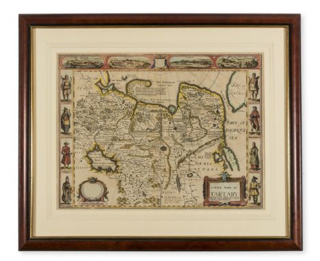
Lot 11
Asia.- Speed (John) A Newe Mape of Tartary, detailed map showing from Lake Baikal through the regions of present-day Manchuria and Siberia to the north of the Great Wall of China, with Korea as an Island, featuring 8 side panels with the people of Tartary in their native costume, and four vignette views above of Nova Zembla, and the silk route cities of Astrakan, Samarkand and Cambalu, engraving with early hand-colouring, 405 x 520 mm. (16 x 20 1/2 in), under glass, central vertical fold, two light creases, minor spotting and browning, framed and glazed, Bassett and Chiswell, 1676.

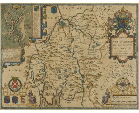
Lot 112
NO RESERVE Cumbria.- Speed (John) The Countie Westmorland and Kendale the Cheif Towne Described, county map with decorative strap-work cartouches, an inset map of Kendale, engraving on laid paper with early hand-colouring, platemark 390 x 515 mm. (15 1/4 x 20 1/4 in), sheet 400 x 525 mm. (15 3/4 x 20 3/4 in), under glass, central vertical fold, handling creases, some surface dirt and light browning, Bassett and Chiswell, [circa 1676]; together with Robert Morden's map of Cumberland, engraving with hand-colouring, 375 x 430 mm. (14 3/4 x 17 in), under glass, central vertical fold, handling creases, framed and glazed, sold by Abel and Churchill, [circa 1695 and later] (2).
Lot 113
NO RESERVE Derbyshire.- Tuke (John) A Map of Ninety Miles by Seventy Five in which Chesterfield is the Centre, Comprising the Counties of Derby and Nottingham, Part of the Counties of York, Lincoln, Rutland, Leicester, Stafford, Salop, Chester and Lancaster, engraved map with hand-colouring, mounted on linen with wooden rollers, sheet 670 x 770 mm. (26 1/2 x 30 1/4 in), some surface dirt and light browning, unframed, rolled, Darton & Harvey, 1798; together with Frederic Sanderson's Poor Law Union and Parish Map of the County of Nottingham Exhibiting in a Comprehensive Manner the Railway System of the District, engraved map with hand-colouring, 740 x 540 mm. (29 1/4 x 21 1/4 in), mounted on linen with early wooden rollers, varnish with some discolouration, other minor surface dirt, unframed, rolled, 1861; and with a rolled map by John Cary of Derbyshire, engraving with some hand-colouring, sheet 670 x 570 mm. (27 1/2 x 22 1/2 in), some off-setting and surface dirt, nicks and tears to margins, 1818 (3).
Lot 115
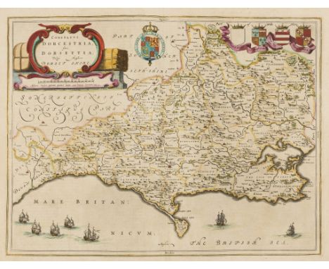
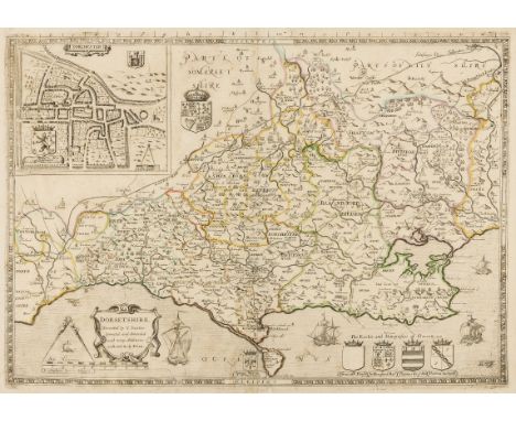
Dorset.- Blaeu (Joan) Comitatus Dorcestria, sive Dorsettia; vulgo Anglice Dorset Shire, county map with harvest-themed title cartouche in the upper left, and seven ships off the southern coast, engraving with hand-colouring, on laid paper with indistinct armorial watermark, platemark 380 x 505 mm. (15 x 19 7/8 in), sheet 460 x 585 mm. (18 1/8 x 23 in), Dutch text verso, central vertical fold, minor handling creases, light surface dirt and browning, unframed, [circa 1650] § Saxton (Christopher) and William Kip (engraver). Dorcestriae Comitatis Vulgo Dorsett, engraved map with some hand-colouring, 275 x 390 mm. (10 3/4 x 15 3/8 in), sheet 335 x 440 mm. (13 1/4 x 17 1/4 in), Latin text verso, central vertical fold, handling creases, some surface dirt, unframed, [circa 1607 and later]; together with a hand-coloured map of Dorset by Robert Modern, and three others by Moll, Cary, and another, engravings, 365 x 420 mm. (14 3/8 x 16 1/2 in), and smaller, occasional minor surface dirt and browning, all unframed, mainly early 19th century (6).
Lot 116
Dorset.- Saxton (Christopher) Dorsetshire Described by C. Saxton. Corrected and Amended with Many Additions as Roads &c. by P. Lea, county map with inset plan of Dorchester in the upper left corner, engraving on laid paper, with outline hand-colouring, platemark 385 x 540 mm. (15 1/4 x 21 1/4 in), sheet 400 x 565 mm. (15 3/4 x 22 1/4 in), central vertical fold with some repaired splitting, other small repairs, minor surface dirt and light browning, unframed, [circa 1689 and later].

Lot 117
Dorset.- Speed (John) and Henry Overton. Dorsetshyre With the Shyre towne Dorcester described, engraved map on laid paper with fleur-de-lis, platemark 385 x 510 mm. (15 1/8 x 20 1/8 in), sheet 465 x 565 mm. (18 1/4 x 22 1/4 in), central vertical fold with slight browning, minor surface dirt, unframed, Henry Overton, [1662 but circa 1740s] § Blaeu (Joan) Comitatus Dorcestria, sive Dorsettia; vulgo Anglice Dorset Shire, county map with harvest-themed title cartouche in the upper left, and seven ships off the southern coast, engraving on laid paper with indistinct armorial watermark, platemark 305 x 505 mm. (12 x 19 7/8 in), sheet 515 x 580 mm. (20 1/4 x 22 3/4 in), Latin text verso, central vertical fold with handling creases, minor surface dirt, unframed, [circa 1650] (2).

Lot 12
South East Asia.- Ortelius (Abraham) Indiae Orientalis Insularumque Adiacientium Typus, map of southern Asia from India across to Java and New Guinea, and including China and Japan to the north, with Portuguese coat of arms, at top left, mermaids and a sea monster observing a floundering vessel, engraving with early hand-colouring, on laid paper with crossed arrows watermark, platemark 350 x 502 mm. (13 3/4 x 19 3/4 in), sheet 415 x 530 mm. (16 1/4 x 20 7/8 in), Latin text verso, central vertical fold, some repaired splitting to upper and lower sections, careful restoration to nicks and tears at extremities of the sheet, unframed, [Antwerp, 1571].Literature:VdB 166
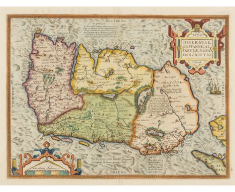
Lot 122
Ireland.- Ortelius (Abraham) Eryn - Hiberniae, Britannicae Insulae, Nova Descriptio - Irlandt, map of Ireland, with north oriented to the right, strap-work title and scale cartouches, with a ship off the northern coastline, engraving on laid paper with armorial watermark, fine early hand-colouring, platemark 355 x 485 mm. (14 x 19 in), sheet 445 x 565 mm. (17 1/2 x 22 1/4 in), Latin text verso, central vertical fold, two small parallel splits in the upper right margin, minor handling creases and light surface dirt, unframed [Antwerp, 1584].Literature:VdB 22 .2⁂ Based on Mercator's 1564 wall map of the British Isles, it is the first map of Ireland to include any geographic details.

Lot 123
Ireland.- Teesdale & Co. (Henry) Ireland, detailed map showing counties, with parts of Scotland, Wales, and Cornwall to the right, engraved map with hand-colouring, on Whatman wove paper with watermark date of 1820, sheet 660 x 540 mm. (26 x 21 1/4 in), old folds with small area of splitting with repairs, other small repaired nicks to extremities, minor surface dirt, unframed, [circa 1820s].

Lot 124
Ireland.- Visscher (Nicolas) Hiberniae regnum tam in praecipuas Ultoniae, Connaciae, Lageniae, et Momoniae, map of Ireland with two decorative cartouches, one showing Perseus on Pegasus, rescuing Andromeda from the sea-monster, engraving with hand-colouring, 590 x 540 mm. (23 1/4 x 21 1/4 in), dissected and mounted on linen, a few folds with splitting, some minor surface dirt and creasing, folding without slip-case, 8vo, [circa 1680-1710].
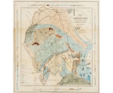
Lot 126
Lake District.- Ruthven (John) Map of the English Lakes and Adjoining Country Geologically Coloured, geological map showing from Lancaster north to Carlisle, and from Whitehaven to Brough, with four diagrams of cross-sections of land around the border, engraving, with extensive hand-colouring, 550 x 510 mm. (21 3/4 x 20 1/8 in), horizontal and vertical folds with some minor repairs to splitting, laid onto thin linen support, light surface dirt, unframed, John Garnett, Windermere, 1855.

Lot 127
Lancaster.- Speed (John) The Countie Pallatine of Lancaster, described and divided into Hundreds, county map of Lancashire by Jodocus Hondius, with inset plan of Lancaster, upper right, two panels in lower corners, each with four royal portrait medallions of the Houses Lancaster and York with rose-scroll ornament, strapwork title cartouche upper centre, compass rose, ships, merman and sea monsters, engraved map with hand-colouring, a very good clean impression, 390 x 510 mm. (15 1/4 x 20 in), English text verso, with woodcut initial, central vertical fold, Bassett and Chiswell, [1676].

Lot 128
London.- Mogg (Edward) An Entire New Plan of the Cities of London & Westminster with the Borough of Southwark, Comprehending the New Buildings and other Alterations, to the Year 1805, showing from Hyde Park to Mile End in the east, and Lambeth to Islington, engraved map, with some outline hand-colouring, 460 x 890 mm. (18 1/8 x 35 in), dissected and mounted on linen, browning and surface dirt, some handling creases, folding without slipcase, [Howgego 227 (3)], 1805.

Lot 13
NO RESERVE South East Asia.- Stanford (Edward) Stanford's Map of the Far East, lithograph printed in colour, 1120 x 870 mm. (44 x 34 1/4 in), dissected and mounted on linen, some surface dirt and browning, small loss and stains to corners, folding with brown endpapers, printed title to upper panel, without slip-case presumably as issued, 8vo, Edward Stanford, [early- to mid-20th century].
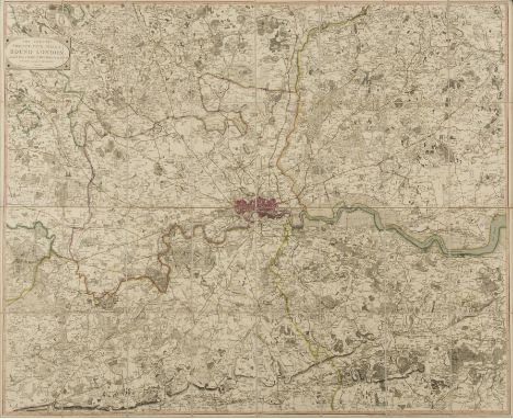
Lot 131
London.- Faden (William) The Country Twenty-Five Miles Round London..., 4th edition, from Windsor to Basildon, and Ware to Reigate, title cartouche upper left, engraved map with original outline hand-colouring, 1050 x 1290mm. (41 3/8 x 50 3/4 in), dissected and mounted on linen, light surface dirt and browning, some spots, lacking slipcase, [Howgego 188 (8)], 1820.
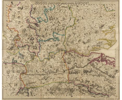
Lot 132
NO RESERVE London.- Mogg (Edward) Mogg's Forty-Five Miles Round London, showing the home counties from Saffron Walden to Rye, and Basingstoke to Faversham, engraved map early outline hand-colouring, 970 x 1180mm. (38 1/4 x 46 1/2 in), dissected and mounted on linen, minor spotting and browning, light surface dirt, folding with brown endpapers into contemporary green marbled slipcase, with printer's label, worn, 4to, [Howgego 287 (1)], 1821.
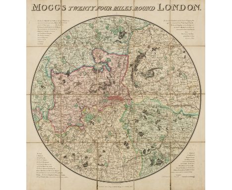
Lot 134
London.- Mogg (Edward) Mogg's Twenty Four Miles Round London, circular map from Crowhurst to Stapleford in the north, and from Windsor to East Tilbury in the east, engraved map with early hand-colouring, 615 x 580 mm. (24 1/4 x 22 3/4 in), dissected and mounted on linen, one small split to fold, minor offsetting, very light browning and surface dirt, folding into later slipcase, rubbed, [c.f. Howgego 235, unrecorded state between (7) and (8)], 1824.

Lot 135
London.- Smith (Charles) Smith's New Plan of London, Westminster & Southwark, 1825, showing from Elephant & Castle to Islington, and Hyde Park to the East India Docks, with extensive key below featuring 350 alphabetical references, engraved map with outline hand-colouring, 420 x 760 mm. (16 1/2 x 29 7/8 in), dissected and mounted on linen, surface dirt and browning, handling creases, folding without slipcase, [Howgego 225 (15)], 1825.

Lot 136
London.- Smith (Charles) Map of the Country Twelve Miles Round London, showing from Ewell to Enfield, and from Southall to Hornchurch in the east, engraved map by W.R. Gardner, with early hand-colouring, 745 x 875mm. (29 3/8 x 34 1/2 in), dissected and mounted on linen, folding with brown endpapers, with contemporary green slipcase featuring publisher's original printed label, [Howgego 288 (6)], 1835.

Lot 137
London.- Mogg (Edward) Mogg's Strangers Guide to London, Exhibiting all the various Alterations & Improvements complete to the Present Time, showing from Hyde Park to Stepney Green in the east, and Kennington to Islington, with 500 key reference list below, engraved map with hand-colouring, 510 x 605 mm. (20 1/8 x 23 3/4 in), dissected and mounted on linen, with some offsetting and minor surface dirt, folding with brown endpapers, in original slipcase with printer's label, splitting and worn, [Howgego 238 (7)], 1835.

Lot 138
London.- Cruchley (George Frederick) New Map Extending 24 Miles Round London, showing all the Mail, Turnpike, and Cross Roads, Gentleman's Seats, parks etc. etc. Also all the Proposed Railways, &c., circular map, with ornamental design in spandrels, engraved map, 690 x 710 mm. (27 1/4 x 28 in), dissected and mounted on linen, minor surface dirt, folding with green marbled endpapers, in matching slipcase with printer's label, worn, [unrecorded state between Howgego 347 (2) and (3)], 1838.

Lot 141
NO RESERVE London.- Laurie (Richard Holmes) Survey of the Country Around London to the Distance of Thirty-Two Miles from St. Paul's, from Ware to Reigate and from Chatham to Taplow, title panels above, engraved map, by Alex Findlay, with early hand-colouring, 675 x 860 mm. (26 1/2 x 33 7/8 in), dissected and mounted on linen, some surface dirt and minor browning, folding with marbled endpapers into publisher's embossed red cloth boards, rubbed, 8vo, [unrecorded edition after Howgego 321 (5)], 1876.

Lot 142
NO RESERVE London.- Smith (Charles, publisher) Reynolds's Map of London with the recent Improvements, lithographed map printed in colours, 605 x 880 mm. (23 3/4 x 34 3/4 in), dissected and mounted on linen, folding into green cloth, gilt tooled boards, with 31 pp. 'London Guide', 8vo, 1902; together with Reynolds's New Coloured Chart of the Thames Estuary extending to Harwich & Ramsgate, lithographed map printed in colours, with separate folding plan of The River Thames, 560 x 640 mm. (22 x 25 1/4 in), mounted on linen, folding into blue cloth boards, worn, 8vo, 1895; and with a folding Map of Public Footpaths, North and West London, published by Northern Heights Footpath Association, 1895 (3).

Lot 144
Norfolk.- Bryant (Andrew) Map of the County of Norfolk, From an Actual Survey, vignette view of Norwich Cathedral lower right, with key to map lower left, large engraved folding map, in six sections, each approx. 725 x 780 mm. (28 1/2 x 30 3/4 in), dissected and mounted on old linen, each section folding with ink annotations on endpapers, some minor spotting and surface dirt, folding into contemporary green cloth slipcase, split and very worn, small 4to, published by Bryant, 1826.⁂ Large detailed map in the manner of Greenwoods, yet said to be somewhat more scarce.
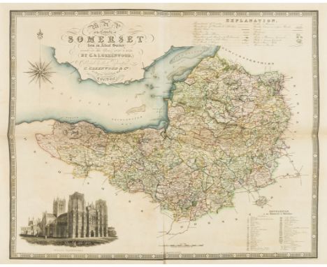
Lot 149
NO RESERVE Somerset.- Greenwood (Christopher) Map of the County of Somersetshire, from Actual Survey Made in the Years 1820 & 1821, county map with vignette of Wells Cathedral in the lower left, decorative calligraphic title in the upper left corner, engraving with early hand-colouring, platemark 630 x 730 mm. (24 3/4 x 28 3/4 in), sheet 650 x 800 mm. (25 1/2 x 31 1/2 in), central and vertical folds with some splitting, handling creases, light surface dirt, 1829; together with Greenwood's 'Map of the West Riding of the County of York', engraving with hand-colouring, sheet 605 x 850 mm. (23 3/4 x 33 1/2 in), some off-setting and browning, folds with minor splitting, unframed, 1834 (2).
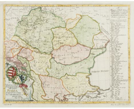
Lot 15
Balkans.- Földek (Mély) A' Magyar-Török Hadakozasoknak Mutato Piatza, map of the Balkan region including Hungary, with Romania below Bulgaria, text in Hungarian, engraving with hand-colouring, on laid paper with crown watermark surmounting the letters 'I.T.E.V.T', sheet 360 x 440 mm. (14 1/4 x 17 1/4 in), old folds, minor surface dirt, some nicks and tears, unframed, 1790.

Lot 150
Somerset.- Speed (John) Somerset-Shire described, inset bird's-eye view of Bath, upper left, coats of arms lower left, royal arms and ships off the north coast, engraved map with hand-colouring, 385 x 510 mm. (15 1/4 x 20 in), English text verso, central vertical folds and creases, nicks and tears to extremities, surface dirt and browning, on repaired tear to lower right corner outside of map, unframed, Bassett & Chiswell [circa 1676].

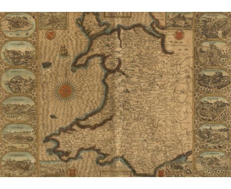
Lot 151
Wales.- Ortelius (Abraham) Cambriae Typus Auctore Humfredo Lhuydo Denbigiense Cambrobritano, map of Wales, with details of mountain ranges, forests, and towns, strap-work title cartouche, sea monster, and ship off the coast, engraving, on laid paper with crossed arrows watermark, fine early hand-colouring, platemark 375 x 495 mm. (14 3/4 x 19 1/2 in), sheet 452 x 560 mm. (17 3/4 x 22 in), Latin text verso, reinforced central vertical fold, minor surface dirt and handling creases, unframed, [Antwerp, 1592]. Literature:VdB 21.2

Lot 152
NO RESERVE Wales.- Speed (John) Montgomery Shire, county map of Montgomery, engraving on laid paper with armorial watermark, with hand-colouring, sheet 387 x 510 mm. (15 1/4 x 20 1/8 in), English text verso, central vertical fold, trimmed to borderline, some nicks and scuffs to extremities, inset plan of the town supplied in facsimile, unframed, 1610-11 and later.
Lot 153
Wales.- Speed (John) Wales, decorative map with the four corners showing the diocesan cities of Bangor, St. Asaph, Llandaff and St. David's, while the compass rose bears the arms of the Prince of Wales, the two side panels show the twelve county towns of Wales, excluding Monmouth, engraved map with early hand-colouring, platemark 380 x 510 mm. (15 x 20 1/8 in), under glass, central vertical fold, light even-browning, minor nicks to extremities, and surface dirt, framed and glazed, Basset & Chiswell, [1676]

Lot 17
NO RESERVE Canada.- Philip & Son (George, publisher) Picture Map of Newfoundland, map of the island with inset map showing sea routes to Newfoundland from America and mainland Canada, lithograph printed in colour, 645 x 555 mm. (25 1/2 x 21 3/4 in), folding into contemporary green morocco boards [together with] Newfoundland, Road Map of the Peninsula of Avalon, lithograph printed in colour, 570 x 450 mm. (22 1/2 x 17 3/4 in), folding into boards, gilt title to upper cover with initials 'E.M.W.', slightly worn, 4to, [early 20th century].
Lot 18
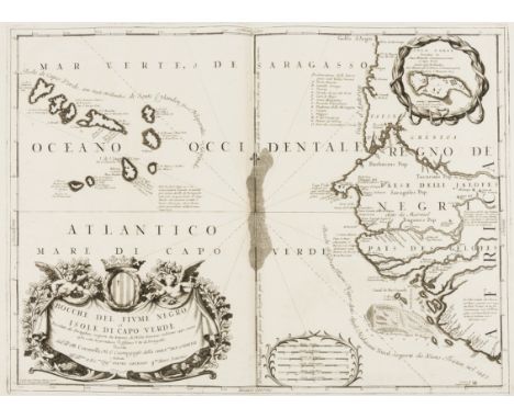
Cape Verde.- Coronelli (Vincenzo Maria) Bocche del Fiume Negro et Isole di Capo Verde, showing Cape Verde Islands and of part of the coast of Senegal to the right, engraved map, an excellent impression on laid paper with swallowtail flag watermark, platemark 460 x 615 mm. (18 1/8 x 24 1/4 in), central vertical fold, light offsetting and surface dirt, unframed, Venice, Padovani, [circa 1696].

Lot 2
NO RESERVE America.- Foster (J.W.) & Whitney (J.D.) Geological Map of the Lake Superior Land District in the State of Michigan, showing the geology of the Upper Michigan Peninsula, Isle Royale and the north shore of Lake Superior and indicates copper, iron, silver, marble furnaces, iron forages and active/inactive mines, lithograph with hand-colouring, three sections joined, total approx. 620 x 950 mm. (24 1/2 x 37 1/2 in), mounted on linen, with handling creases, minor surface dirt and light browning, unframed, J. Ackerman, 1847.

Lot 23
Caribbean.- Sanson (Nicolas) Isle de la Guadeloupe Scitueé a 16 Degree de Lat. Septentrionale, map of Guadeloupe, including parts of the Isle de la Desirade and Marie-Galante, engraving with outline hand-colouring, on laid paper with ecclesiastical watermark with shield before a mantle topped with a crown with tassels falling either side of the coat of arms, platemark 315 x 420 mm. (12 3/8 x 16 1/2 in), sheet 405 x 570 mm. (16 x 22 1/2 in), central vertical fold with discoloured parallel creases, surface dirt, numbered in brown ink in the upper right margin, unframed, Pierre Mariette, [1650]; together with L'Isle de la Martinique Scituee a 14 Degrez 30 Minutes de Latitude Septentrionale, map of Martinique, divided into the abode of the French and the that of the 'savages', engraving with outline hand-colouring, on laid paper with ecclesiastical watermark of shield before a mantle topped with a crown with tassels falling either side of the coat of arms, platemark 320 x 430 mm. (12 1/2 x 17 in), sheet 400 x 570 mm. (15 3/4 x 22 1/2 in), central vertical fold, minor handling creases and surface dirt, numbered in brown ink in the upper right margin, unframed, Pierre Mariette, [1650] (2).
Lot 25
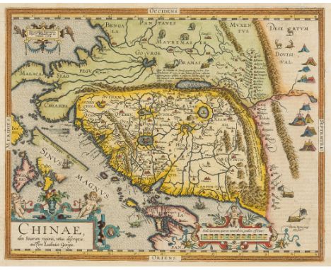
China.- Ortelius (Abraham) Chinae, olim Sinarum regionis, nova descriptio. Auctore Ludouico Georgio, map of China oriented with north to the right, extending into parts of Indo-China, the Philippines and part of Japan, with The Great Wall delineated, and with illustrations in the interior with tent cities of the Tartars, stags, elephants and elaborate sail-powered carriages, engraving with hand-colouring, on laid paper with armorial watermark, platemark 370 x 470 mm. (14 1/2 x 18 1/2 in), sheet 450 x 540 mm. (17 3/4 x 21 1/4 in), central vertical fold with small split to lower margin, repairs to tears in margin centre right, small repaired hole in margin lower left, unframed, [Antwerp, 1603].Literature:VdB 164.3⁂ The first European-printed map of China.

Lot 28
NO RESERVE China.- Stanford (Edward) Stanford's Map of the Empires of China and Japan with the Adjacent Parts of the Russian Empire, India, Burma, &c., engraving with hand-colouring, 675 x 1030 mm. (26 1/2 x 40 1/2 in), dissected and mounted on linen, yellow endpaper with publisher's printed advertisement, folding into original green cloth boards with printed title to upper cover, rubbed, 8vo, Edward Stanford, 1900.
Lot 29
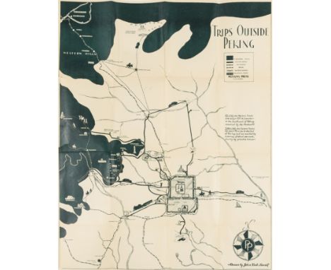
China.- Sewall (John Kirk) Map of the Western Hills, including a detailed description of the spots of interest and of the roads leading to same, title and 9 pp. of descriptive text, with map 'Trips Outside Peking' showing Beijing with old city wall, the inner city wall and the Imperial City, and other locations of interest in the surrounding area, lithograph printed in dark-green, 580 x 470 mm. (22 3/4 x 18 1/2 in), two tears into map, folding into original paper wrappers, printed title to upper cover, some surface dirt and finger-soiling, with original slip-case, rubbed and slightly worn, 8vo, Peiyang Press, Ltd. 1935 § Wyld (James) Map of China Compiled from Original Surveys & Sketches, showing China and Korea, with The Great Wall and the Imperial Canal both depicted, engraving with some hand-colouring, 650 x 830 mm. (25 5/8 x 32 3/4 in), dissected and mounted on linen, some minor off-setting and light browning, folding with blue marbled ends, surface dirt, without slip-case, 1841 (2).
Lot 3
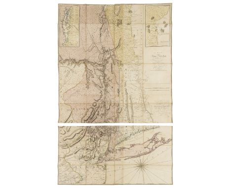
America.- New York.- Montresor (John) A Map of the Province of New York, with Part of Pensilvania, and New England, wall map of New York to the east and west of the Hudson River Valley, including all of Long Island and parts of Connecticut and New Jersey, engraving with hand-colouring, total approx. 1455 x 935 mm. (57 1/4 x 36 3/4 in), dissected and mounted on linen, but split along horizontal fold, three sections up from the bottom, otherwise some light off-setting, minor browning and surface dirt, folding into later cloth drop-back box, 4to, A. Dury, 1775.

Lot 30
Egypt.- Ortelius (Abraham) Aegyptus Antiqua, two-sheet map of ancient Egypt, with inset map of Alexandria and its surroundings, the bottom sheet with dedication cartouche to the humanist and medical doctor Scipio Fabio of Bologna, with strap-work cartouches, ships sailing in the Mediterranean Sea, pyramids, and decorative border, engravings, with early hand-colouring, on laid paper both with crossed arrows watermark, each platemark approx 402 x 482 mm. (15 7/8 x 19 in), sheets 455 x 570 mm. (17 7/8 x 22 1/2 in), Latin text on verso, good margins, central vertical folds, minor nicks to extremities, some surface dirt and finger-soiling, unframed, [Antwerp, 1584] (2).Literature:VdB 219.1 and 220.1

Lot 31
Europe.- Ortelius (Abraham) Europam, sive Celticam Veterem ..., map of ancient Europe based on classical sources such as Salustius, Plinius, Herodotus, Strabo and Dionysius, engraving with early hand-colouring, on laid paper with armorial watermark, platemark 360 x 480 mm. (14 1/4 x 18 7/8 in), sheet 420 x 530 mm. (16 1/2 x 20 3/4 in), Latin text verso, central vertical fold, re- margined to lower border, minor handling creases and surface dirt, unframed, [Antwerp, 1595 but later].Literature:VdB 189.1

Lot 34
Europe.- Roman Empire.- Ortelius (Abraham) Romani Imperii Imago, map of the Roman Empire centered on the Mediterranean and covering most of Europe, Northern Africa, and the Near and Middle East, with genealogical tree of the rulers of Rome at right, and an account of Roman history lower left, engraving with early hand-colouring, on laid paper with crossed arrows watermark, platemark 345 x 500 mm. (13 1/2 x 19 3/4 in), sheet 460 x 555 mm. (18 1/8 x 21 3/4 in), Dutch text verso, central vertical fold, some surface dirt, faint exposure lines in margin from previous mount, minor handling creases in margins, unframed, [Antwerp, 1598]Literature:VdB 187.2

Lot 4
NO RESERVE America.- Wyld (James, publisher) Strategic War Points of the United States: The Country Round Washington. The Chesapeake and the Potomac, map showing from Philadelphia in the north to the northern boundary of the State of North Carolina, and from Liberty (Virginia) to the Atlantic, lithograph with outline hand-colouring, 340 x 520 mm. (13 3/8 x 20 1/2 in), dissected and mounted on linen, printed advertisement verso, folding into original cloth boards with publisher's label, rubbed and worn, 8vo, circa 1861.

Lot 40
France.- Côte d'Azur.- Anonymous (early 19th century) Carte des environs d'Antibes, map and plan of the port and town of Antibes, including the surrounding area, with a line delineating the are of patrol by garrison soldiers, pen and brown ink, watercolour, on cream laid paper with watermark of fleur-de-lis, sheet 392 x 530 mm. (15 1/2 x 20 7/8 in), central and vertical folds, some splitting, minor spotting and surface dirt, unframed, [probably early 19th century].
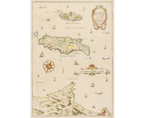
Lot 41
NO RESERVE France.- Côte d'Azur.- Tassin (Charles, publisher) Description Du Cap De La Croix Isles Ste Marguerite et St Honorat, map showing Cannes and the Cap de la Croisette, with the islands of St Marguerite and St Honorat, including many ships, sea monsters, and with title cartouche upper right, engraving with hand-colouring, sheet 520 x 370 mm. (20 1/2 x 14 1/2 in), trimmed to borderline and re-margined, handling creases and light folds, minor nicks, surface dirt, unframed, [circa 1640].Literature:Pastoureau, M. Tassin II-33
-
109182 item(s)/page