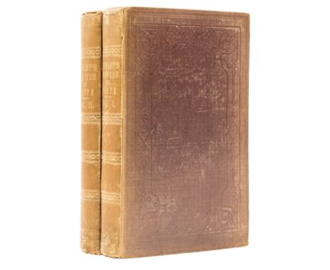

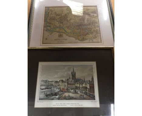
Crete.- Pashley (Robert) Travels in Crete, 2 vol., first edition, half-titles, 10 lithographed plates, folding map and plate of inscriptions, wood-engraved illustrations, some full-page, occasional ink and pencil notes to margins, 1 or 2 additional illustrations laid onto blank margins, vol. 1 title remains of adhesive strip to inner margin, bookplate and ink ownership inscriptions to pastedown and endpapers, original cloth, light sunning to spines, spine ends and corners a little bumped and frayed but a good set overall, [Blackmer 1263; Not in Abbey], 8vo, Cambridge & London, 1837.⁂ "First edition of this important work... Pashley spent most of 1834 in Crete, exploring it in detail. He was accompanied by Antonio Schranz, a member of the Maltese family of artists, who did the drawings... Pasley and Schranz visited practically every village, monasteries, ancient sites, etc. and have produced a detailed account of the island." - Blackmer.
We found 109182 price guide item(s) matching your search
There are 109182 lots that match your search criteria. Subscribe now to get instant access to the full price guide service.
Click here to subscribe- List
- Grid
-
109182 item(s)/page
![Mediterranean.- Arabic inscribed maritime pilot.- Colom (Jacob Aertsz) [Colomne Ardante de la mer Méditerranée], 9 double-pag](https://cdn.globalauctionplatform.com/b7ed54e3-d8c6-448e-b190-ae8a010a1cd3/238de418-f4c8-4ea5-aa4d-ae8a011091d1/468x382.jpg)
Mediterranean.- Arabic inscribed maritime pilot.- Colom (Jacob Aertsz) [Colomne Ardante de la mer Méditerranée], 9 double-page maps only, 8 by Colom, numbered in the plates from '2' to '9', plate '1' replaced with Johannes de Ram's map of the Mediterranean 'Paskaart vande Middelandsche Zee In twee deelen vertoont...', charts 2 to 9 cover the Straits of Gibraltar, the Barbary Coast, Majorca, the coastline around Barcelona, Nice, Corsica, Sardinia, Southern Italy, Sicily, and Croatia, engraved charts, each sheet approx. 440 x 550 mm (17 1/4 x 21 3/4 in), each mounted on stiff paper with maps back-to-back, with thick red and black ink borderlines, Arabic inscriptions translating location names throughout, heavy spotting and browning throughout, some cockling and losses to sheets, old repaired tears, creases and signs of heavy use, contemporary stiff paper covers, worn with losses, maunscript label to lower cover pasted upside down that reads 'Carta Marinaresca/ del Mar Mediterraneo', folio, [Amsterdam, circa 1670-1680]⁂ Unusual working copy of Colom's rare pilot, owned by a mariner fluent in Arabic. Koeman highlights the rarity of Colom's pilot books and notes that despite 'thousands of copies [being] circulated [...] only a score have survived'. [Koeman IV, p. 120]

Voyages.- Schouten (Willem Corneliszoon) Journal ou Description du Merveilleux Voyage...en circum-navigeant le Gobe terrestre..., second Amsterdam edition in French, engraved title-vignette, double-page engraved twin-hemisphere world map supplied from another edition with Dutch text to verso, 3 other folding engraved maps (one with a few small repaired holes at old fold), 5 engraved double-page or folding plates (at least 3 from another edition with Dutch text on verso), C3-D1 with very slight worming in text, later calf, gilt, corners and spine ends worn, rubbed, [Sabin 77948; Hill pp269-270], 4to, Amsterdam, Chez Harman Ianson, 1619.⁂ A good, albeit sophisticated, copy. "This is the account of Schouten's voyage around the world, during which Cape Horn, named after Schouten's native town [Hoorn], was discovered, and first rounded. The leading citizens of Hoorn had helped finance the expedition by joining together under Isaac Le Maire to found the Compagnie Australe. The newly-discovered passage to the Pacific Ocean was named the Strait of Le Maire. Although published under Schouten's name, it is not certain that he was the true author of this journal, which was edited and compiled by the mapmaker, Willem Jansz Blaeu. It is probably compiled from one or more of the log books of the voyage and perhaps mainly from one kept by the commissary Aris Claezoom. The ship Eendracht, while crossing the Pacific, discovered some of the Tuamotu Islands, the northern Tonga Islands, the Hoorn Islands, the Schouten Islands, and visited New Guinea, the Moluccas, and Batavia... Several of the maps are of great importance for the history of Pacific cartography. The northern coast of New Guinea was revealed and charted for the first time with some definiteness of detail." (Hill).Provenance: Anselme de Bonnaire (ink name on title and verso, dated 1631); Thomas Philip Earl de Grey, Wrest Park (bookplate); "B.L." (unidentified 20th century bookplate)

British Isles.- Ortelius (Abraham) Britannicarum Insularum Vetus Descriptio, two-sheet map of ancient Britain, probably engraved by Jan Wierix, with four ornate strap-work cartouches, a naval battle in the upper left, and a number of other vessels around the coast, engravings on laid paper with full hand-coloured, two sheets expertly joined, total platemark approx. 725 x 485 mm (28 1/2 x 19 1/4 in), Latin text visible verso, central vertical folds as issued, minor printer's creases, framed and glazed, Antwerp, 1590Literature:VdB 190-191⁂ Excellent example of this two-part map, which only appeared in the early editions, being replaced by a single plate in 1595.
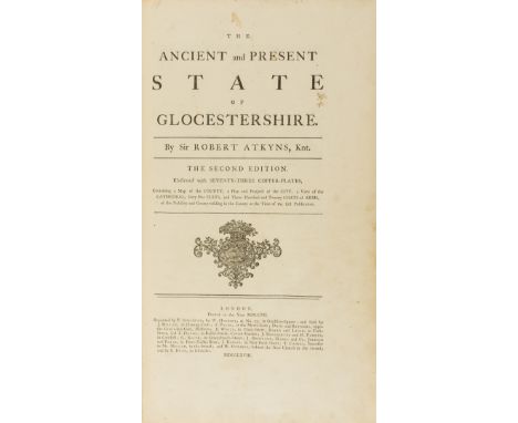
Gloucestershire.- Atkyns (Sir Robert) The Ancient and Present State of Gloucestershire, second edition, large paper copy, double-page engraved map, 8 plates of coats-of-arms and 64 double-page views by Kip, with Author's Epitaph and Directions to Binder f. following preface and advertisement, occasional light spotting or finger-soiling, mostly marginal, some leaves or plates with short marginal tears, some plates creased, otherwise a generally crisp and clean copy, contemporary panelled calf, spine gilt in compartments, lightly rubbed, folio, T. Spilsbury, for W. Herbert [&c.], 1768.⁂ An excellent large paper copy of the second edition. Thomas Kip's views of country seats, first published in 1712, make this one of the best known topographical works of the eighteenth century.
Scotland & Ireland.- Blaeu (Willem Jansz. and Joan) Novus Atlas, Das ist, Weld-beschreibung, Mit schönen newen außführlichen Land-Taffeln in Kupffer gestochen [Volume V. Scotland and Ireland], engraved title with Scottish coat of arms and architectural facade containing letterpress title on overslip, 52 double-page and one single-page engraved maps, all with early hand-colouring, title and maps mounted on stubs, browning, off-setting, spotting and staining throughout, sometimes very heavy to both text and maps, title with heavy surface dirt and browning, marginal tears and rough edges, the overslip with ink inscription from previous owner and area of abrasion to lower right, 'Scotia Antiqua' map trimmed at the right side and lacking panel with cartouche, several maps with splitting to central vertical folds, numerous marginal nicks and small losses throughout, some heavy handling creases, original publisher's vellum panelled in gilt, lacking green silk ties, covers soiled, warped, corners bumped, worn, folio, Amsterdam Joan Blaeu, 1654.⁂ The 'first printed county atlas' of Scotland [Koeman]. German edition of Blaeu's atlas of Scotland and Ireland, comprising volume V of the Novus Atlas.
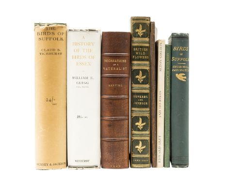
Birds.- Babington (Churchill) Catalogue of the Birds of Suffolk, first edition in book form, presentation copy inscribed by the author, map frontispiece, 7 plates, occasional foxing, original cloth, John Van Voorst, 1884-86 § Ticehurst (Claud B.) A History of the Birds of Suffolk, first edition, folding map, original cloth, dust-jacket chipped and with piece missing from lower panel, 1932 § Glegg (William E.) A History of the Birds of Essex, first edition, plates, folding map, original cloth, dust-jacket, slightly frayed at spine ends, 1929 § Tuck (Rev. Julian G.) Ornithology of Suffolk, offprint, author's own copy with his ink ownership inscription and numerous ink annotations on interleaves, original cloth, Sheffield, William White, 1891; and 4 others, birds and botany, 8vo (8)
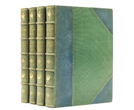
Birds.- Delacour (Jean) The Waterfowl of the World, 4 vol., first edition, 66 colour plates by Peter Scott, 155 map illustrations, vol. 1-3 signed by the artist on front free endpaper, vol. 4 with signed presentation inscription from the author and Peter Scott on front free endpaper, each with an original ornithological illustration by Scott, contemporary blue half morocco by Sangorski & Sutcliffe, gilt, lightly rubbed, spines slightly sunned, t.e.g., [Nissen ZBI 1065], 4to, 1954-64.⁂ The original illustrations are in fountain pen in vol. 1 and 2, and watercolour in vol. 3 and 4.
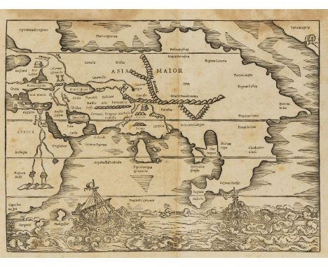
Solinus (Caius Julius) Polyhistor, Rerum Toto Orbe Memorabilium Thesaurus Locupletissimus, second edition, collation: a6 B4 a-z4 Aa-Ff4, 2 folding woodcut maps by Sebastian Munster (one of which browned, with small tear at fold foot and small hole to blank margin), numerous woodcut illustrations (some whole page), printer's woodcut device to title and final f. verso, book label laid down to title (obscuring previous ink ownership inscription), bookplates, some cracking to gutter (worst at 1C and hinges), several ff. browned, some light marginal browning and damp-staining, contemporary vellum with morocco label to spine, repair to spine head, small amount of worming to spine, [Adams S-1394; Burden 11], folio (c.300 x 194mm.), Basel, Michael Isingrin, 1543.⁂ Munster's double-page map entitled Asia Minor, which appears here as it did in his first edition of Solinus' Polyhistor in 1538, is the earliest printed map focusing on the continent of Asia, and also contains the first printed representation of the Pacific coast of America.

Hills (Robert) Etchings of Red Deer, etched title and 62 plates on 46 sheets, 1812; Fallow Deer Drawn from Nature, etched title and 79 plates on 52 sheets, 2pp. autograph letter from the author to Lady Jackson pasted to front free endpaper, 1813, bookplate of Lord Gwydyr, some scattered foxing, affecting many but not all plates, uniform contemporary diced calf, gilt, rebacked, with original spine laid-down, quite rubbed, a few scuffs and chips at extremities, folio (2)⁂ In his undated letter, Hills discusses the deer in Kensington Gardens, with a sketched map and pencil drawing of a deer beneath trees.
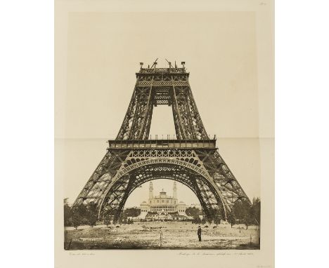
Eiffel (Gustave) La Tour de Trois Cents Mètres, 2 vol., one of 500 copies (numbering not uniform), signed presentation copy from the author inscribed "A l'Institution of Engineers and Shipbuilders in Scotland de Glasgow. Hommage de G.Eiffel" on half-title of vol.1, etched portrait (spotted), titles in red & black with vignette, text with illustrations, 2 leaves of facsimile signatures and appendix at end, plate vol. with 53 double-page lithographed or chromolithographed plates numbered I-XLVII as called for (with 8 additional plates but XXVI & XXVII never printed), a few with folding leaf of explanatory text, 13 photogravure plates, 11 double-page, double-page colour map of environs of Paris, all mounted on stubs, text volume lacking pp.181-185, library stamp to titles but an excellent copy, contemporary half morocco, t.e.g., rubbed, particularly joints, spine ends repaired, preserved in modern cloth slip-cases, folio, Paris, 1900.⁂ Magnificent account of the construction of the famous Eiffel Tower, built in 1887-89 for the Universal Exposition in Paris of 1889, and one of the earliest monographs dedicated to a modern building. It was produced at Eiffel's expense for presentation to libraries, institutions etc.

Sale (George, translator) The Koran, Commonly called the Alcoran of Mohammed, first edition of this translation, title in red and black, folding engraved map of Arabia and plate & plan of Mecca, 3 engraved genealogical tables (2 folding), signature cut away from head of title, map torn and neatly repaired, slight worming (mostly single wormhole but developing into a track towards end, generally a good clean copy, book-label and bookplate of E.Lloyd of Rhagatt, contemporary panelled calf, a little rubbed and marked, rebacked with gilt spine, [Rothschild 1811], 4to, C.Ackers, for J.Wilcox, 1734.⁂ The first translation into English directly from Arabic, and a landmark in Quranic studies.


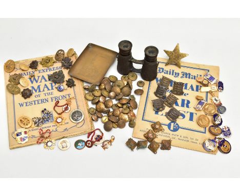
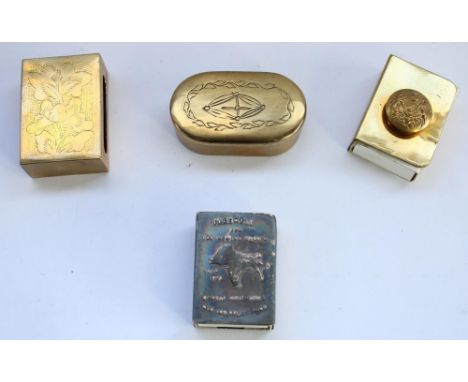
A BOX CONTAINING VARIOUS MILITARY RELATED ITEMS, to include a small pair of binoculars dated 1915, brass napkin ring with five pointed Star applied, brass tray with Monistir design with mosque and Russian double headed eagle on base, six bags of miscellaneous buttons, Cap badges, Industrial Badges, etc and a copy of the Daily Express War Map of the Western Front

A T.G. & CO LTD LONDON MILITARY COMPASS, this example is in good condition for its age, bears the No.B number 13091, MKII dated 1939, the oil filling still present and appears to be fully working etc, together with a Notes On Map Reading 1929 (reprinted with amendments Nos 1 to 4 1939) (edges of pamphlet worn) (2)


After JOHN SPEED (1552-1629) and JOHN NORDEN, a map of Middlesex titled 'Middle-Sex described with the Most Famous Cities of London and Westminster', vignette to lower right reads: 'Solde in Popes head alley againft the Exchange by George Humble', held within double glazed frame with book plate index visible on the reverse, frame size 56cm x 69cm. Creased vertically down middle of the map. Some small areas of wear. Unusual white strip to the right edge.

After JOHN SPEED (1552-1629), a map of Britain titled 'Britain As It was Devided in the tyme of the Enghfhe Saxons efpecially during their Heptarchy', vignette to middle right reads: 'to be fold by John Sudbury and Georg Humble in Popes head alley at London', held within double glazed frame with book plate index visible on the reverse, frame size 57cm x 69cm. We believe this to be an original. Please see additional images to answer any further questions regarding authenticity


After JOHAN BLEAU, map of the East Neuk of Fife titled 'Fifae Pars Orientalis', frame size 58cm x 70cm and After TIMOTHY PONT, map of the Scottish Borders titled 'Lidalia vel Lidisdalia Regio Lidisdail', held within double glazed frame with book plate index visible on the reverse, frame size 50cm x 61cm, (2).

An interesting collection of WWII items relating to 2nd Lieutenant Stanislaw Jasienski, the medal group comprising: Campaign Medal (with M.I.D. oak leaf), Defence Medal, France and Germany Star, Italy Star, Africa Star and 1939-1945 Star, together with a 1943 letter of recommendation from Brigadier G W Lathbury, DSO MBE, an Italy folding silk map, a South Meditteranean folding silk map, a framed certificate commemorating him being M.I.D, loose European coinage, his identity tags and other items. Also included in the lot is a hand-written account by his wife, detailing his movements and capture in 1943/44, having been injured in battle. Jasienski was dropped into Brittany in June 1944 and was shot and then captured, serving time as a POW before being liberated by the Americans.

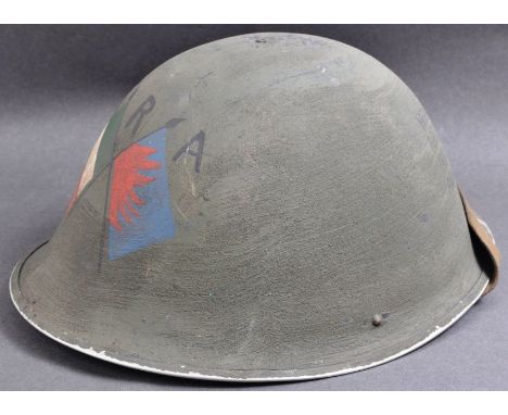
Northern Ireland / Irish Republic Army interest - an original 20th Century British Army turtle helmet painted with later IRA Irish Republic Army paintwork. The helmet having Irish flags to the front above IRA in black text. To the back reads ' Ireland A Nation Irish And Free ' and ' Ireland Unfree Shall Never Beat Peace ' between an outline of the country map.


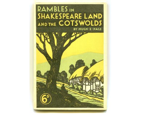
GUIDEBOOKS. A collection of British travel guides and souvenir pamphlets, including 'Rambles in Shakespeare Land and the Cotswolds' by Hugh E. Page, 'Stroud Midst Cotswold Splendour' and 'Harrow and Harrow School, A New Guide Containing Street Plan District Map and Illustrations, Fourth Edition'.Buyer’s Premium 29.4% (including VAT @ 20%) of the hammer price. Lots purchased online via the-saleroom.com will attract an additional premium of 6% (including VAT @ 20%) of the hammer price.
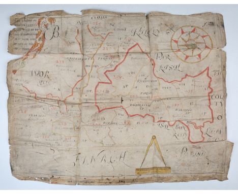
MAP, IRELAND. A folding manuscript map titled 'The Parish of Kilfenaughta and Kilfenienan in the Baronies of Tullagh and Bunrattie in ye Count[ie] of [Clare, Ireland]', hand-coloured in outline with numbered plots, mid 17th-18th century, 605 x 466mm, torn with some loss.Buyer’s Premium 29.4% (including VAT @ 20%) of the hammer price. Lots purchased online via the-saleroom.com will attract an additional premium of 6% (including VAT @ 20%) of the hammer price.


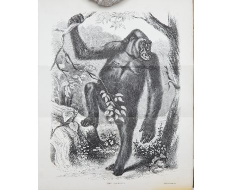
DU CHAILLU (PAUL B.)Explorations & Adventures In Equatorial Africa..., half-calf rebound marbled boards, gilt spine and title, London, 1861 - WARD (ROWLAND): Records Of Big Game..., original gilt blue cloth-covered boards and original zebra end papers, fourth edition, London, 1903 - STONEHAM (C.T): Hunting Wild Beasts With Rifle And Camera, original pictorial green cloth-covered boards, d.w. (slightly torn), n.d. - LAKEMAN (SIR STEPHEN): What I Saw In Kaffir-Land, original red cloth-covered boards with gilt cover illustration and spine title - and three other publications including canvas-backed folding map of Natal, by Stanford, London, in original plain-coloured slip-case (7)This lot is subject to the following lot symbols: •• Zero rated for VAT, no VAT will be added to the Hammer Price or the Buyer's Premium.For further information on this lot please visit Bonhams.com
CRIMEATODLEBEN (E. DE): Défense de Sébastopol, 3 vols. including atlas, maps and plates (many folding), all the pages in the atlas laid on linen text volumes early half calf, atlas later blue morocco gilt, St. Petersburg, N. Thieblin, 1863 - NIEL (ADOLPHE): Siege de Sebastopol. Journal des operations du genie, publie avec l'autorisation du ministre de la guerre, 2 vols. including atlas, 14 engraved plates, light damp stain in the fore-margin of some plates, text in contemporary green quarter morocco, atlas later cloth-backed boards, original printed label on upper cover, Paris, J. Dumaine, 1858, 4to and oblong folio - ARROWSMITH (JOHN): The Crimea, engraved map partly hand coloured, dissected and laid on linen, folding into original slip-case, J. Arrowsmith, 1854 - and ten others relating to the siege of Sebastopol - together with a small group of items and battlefield relics relating to the Crimean War including two cased pairs of binoculars each combined with a compass, one pair impressed 'Chevalier Opticien Paris', a canister of French shot, a framed display of embossed brass food can labels, and various other items (a lot )This lot is subject to the following lot symbols: •• Zero rated for VAT, no VAT will be added to the Hammer Price or the Buyer's Premium.For further information on this lot please visit Bonhams.com
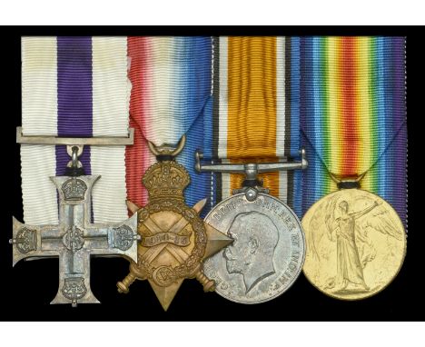
A fine Great War M.C. group of four awarded to Captain A. G. “Jock” Howitt, East Surrey Regiment, a gallant officer of the 12th Battalion who was killed in action at Hollebeke in August 1917 - ‘If there was anything to be done needing courage and a cool head, Jock was the man for the job’ Military Cross, G.V.R., unnamed as issued; 1914-15 Star (2nd Lt. A. G. Howitt, 6th Infantry); British War and Victory Medals (Capt. A. G. Howitt), extremely fine (4) £2,000-£2,600 --- M.C. London Gazette 26 July 1917: ‘For conspicuous gallantry and devotion to duty in leading a raid upon the enemy trenches. The success of the raid was due to his good leadership and cool judgement. He personally reconnoitred No Man’s Land afterwards to make sure that everyone had returned to our lines.’ Adam Gordon “Jock” Howitt was born at Ellon on 11 June 1884, son of Adam Howiott, factor. He was educated Gordon's College, Aberdeen University, from where he graduated B.Sc. (Agr.) in 1910. He entered the service of the Potash Syndicate, and after spending a time in their offices in Germany went in 1912 to South Africa as their Director of Propaganda. Howitt joined the Cape Town Highlanders on the outbreak of war, and took part in 1914-15 in General Botha's Campaign in German West Africa, rising from Private to Lieutenant. On the conclusion of that campaign he came to England, and in October 1915 obtained a commission in the East Surrey Regiment. He served in Ireland during the rebellion, proceeded to France in May 1916, and was severely wounded on the Somme, when the 12th Battalion launched an attack against Flers on 16 September, losing six officers and 112 other ranks killed, and 10 officers and 224 other ranks wounded. After a period at home he returned to France in March 1917, was awarded the Military Cross, and promoted Captain for his services in the Field during the Messines offensive in June 1917, for a successful raid on the enemy’s front line trenches on the 1st of that month, returning with several prisoners and a machine-gun. A few weeks later, on 13 July, he was presented with his M.C. ribbon by Major-General Lawford. He was killed at Hollebeke in the repulse of a sudden counter-attack on 5 August 1917. His Colonel wrote: “Although outnumbered, and under climatic conditions impossible to adequately describe, Captain Howitt and his men beat the enemy back in the fierce hand-to-hand fighting. 'Jock' Howitt died fighting to the last, one of the bravest of the brave... Had he survived he would have secured another well-earned decoration.” Lance- Corporal Farrell, also of ‘D’ Company, later described the advance: ‘At zero hour our guns opened up and the K.R.R.Cs went over the top and we took what shelter we could in their trench. Within a few minutes the wounded started coming back ... the trench we were in was used as a first dressing station, it was packed with wounded. Whether they had advanced into the creeping barrage or the Jerry had got the range, I do not know, but it was evident in a very short time that the attack on this sector had failed ... during the period I saw many V.C.’s earned. However I return to the East Surreys. As the day advanced, things slowed down a bit, and Captain Howitt came along and told us to get ready to go over, and we had to advance to Hollebeke Village. It was peculiar to go over without a barrage of any sort, and all seemed quiet. I was crawling along with my Lewis Gun when the man just in front of me was caught by a sniper in the centre of the forehead, so after that we lay doggo a bit and then went forward again led by Captain Jock. We bombed a few dugouts and soon arrived at some heaps of bricks, which after a bit of map reading Captain Jock decided was the village, the red bricks being the church. Our orders now were to dig in and make a strong point, which we did as well as possible, although the water did not allow us to get very deep. However, we found a Jerry trench later on and tumbled in. We soon went off to sleep, dead beat, but woke to find the water over our necks and my Lewis Gun gone. I dug into the mud and found it. During the day a sniper got busy and picked off several of our men, so Captain Jock and a Sergeant decided to find him. Off they went with revolvers, and a couple of hours later came back saying the sniper would not trouble us again. A brave action this to find a sniper in broad daylight... During this time we saw one Jerry only, and he was wondering about lost, so we took him in tow, and he was a surprised man when Captain Jock gave him a drop of whisky from his waterbottle instead of shooting him.’ Having largely achieved his objective, Howitt’s temporary H.Q. at Forret Farm was suddenly stormed by superior numbers of the enemy. Early reports indicated that he had fallen to a sniper, but as a fellow officer later confirmed - an officer who referred to him as ‘the legendary hero of the 12th Battalion’ - his fate was of a different nature: ‘The real facts were not forthcoming until a runner from ‘D’ Company reported that he had found the Captain dead at Forret Farm with several of the enemy dead around him. Beside him was a man of his company who was severely wounded. Dead men tell no tales but, knowing the man as we did, we could only assume that he and the man beside him made a gallant fight against odds that were too great for them. “Jock” the name by which the men under him knew him, received no posthumous award for gallantry and skilful leading at Hallebeke, but his memory is enshrined in the hearts of the men whom he led as a gallant and loveable personality.’ Aged 33 years, he left a sister who was resident in Aberdeen, has no known grave and is commemorated on the Ypres (Menin Gate) memorial.
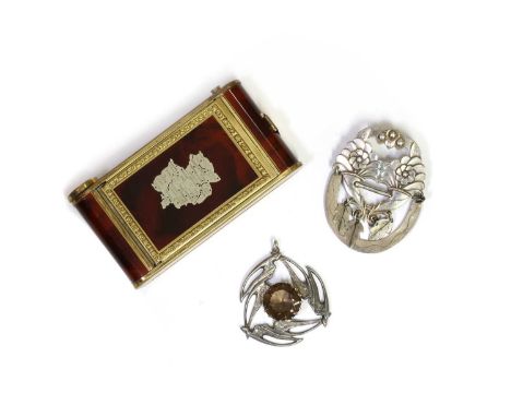
A small collection of jewellery,comprising a Scottish sterling silver smoky quartz pendant, possibly by Celtic Art Industries, with a round mixed cut smoky quartz, approximately 18mm, Edinburgh 1975, 44mm diameter, 15.91g, a silver cornucopia brooch, to pin and roller catch, 61 x 47mm, 11.12g, and a gilt metal 'sweetheart' minaudiere, the camera-shaped minaudiere with a faux tortoiseshell effect finish, with an applied engraved silver map of post WWII Allied-occupied Germany, the minaudiere with powder compact, mirror, lipstick and cigarette case, 10.0 x 5.5 x 1.8cm (3)Minor surface marks/scratches/tarnish to silver. A drill hole to the top of the brooch, probably deficient a drop.One of the foliate drops deficient.The crescent is attached with later base metal wire on one side.Brooch pin is bent.There is a bar of silver to the centre of the brooch, with Swedish assay marks. This bar is possibly a later addition.Surface marks/scratches/tarnish to silver. Wear to the gilt metal, scratches and tarnish, and scratches to the lacquered finish.


Box containing a collection of maps including: Isle of White Second War Revision 1940, Northampton Ordinance Survey map, England, Southwest Ordinance survey map, 4th edition. Midlands Map. Royal Automobile Club 1/4 inch map of England and Wales. Map or central London. Various other ordinance survey maps, Michelin maps. Derby and Leicester ordinance survey map 1954 etc (B.P. 21% + VAT)
Selection of ephemera including address/account book from Towy Vale Colliery, Kestrel engine timer, admiralty map of St. George's channel, History of the French Invasion of Fishguard, workshop manual for Peugeot 404 1961-1970, workshop manual for Hillman Minx/Husky 1956-1965, two framed hunting prints, etc.(B.P. 21% + VAT)
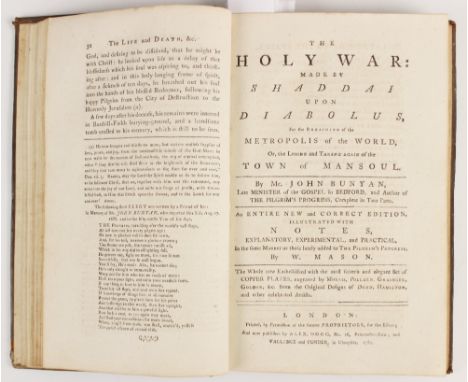
Bunyan (John), THE HOLY WAR: MADE BY SHADDAI UPON DIABOLUS, FOR THE REGAINING OF THE METROPOLIS OF THE WORLD, OR, THE LOSING AND TAKING AGAIN OF THE TOWN OF MANSOUL, first edition, full leather, gilt embossed decoration to spine, laid paper, hand-written bookplate to front free endpaper, engraved frontispiece, fourteen further engraved plates after Dodd, Hamilton and others including the foldout plate 8 (torn on crease), published by Alex, Hogg et al, London 1782, bound with AN AUTHENTIC ACCOUNT OF THE LIFE AND DEATH OF MR. JOHN BUNYAN... BY A FRIEND TO THE CAUSE OF TRUE RELIGION, together with Bunyan (John), THE PILGRIM'S PROGRESS: FROM THIS WORLD TO THAT WHICH IS TO COME, two parts bound in one volume, full leather, gilt embossed decoration to spine, laid paper, hand written bookplate to front free endpaper, engraved frontispiece, fifteen engraved plates after G. Burder (including foldout map), printed for Vallance and Simmons, London 1788 (at fault) (2)

Unexplored Syria Visits To The Libanus, The Tulu. Volume One & Volume Two. 1872. Sir Richard Francis Burton, Charles Frederick Tyrwhitt Drake. Published by Tinsley Brothers, London. First edition. 8vo. Lithographic frontispiece to each volume, folding map, 25 other lithographic plates (11 of which are) folding. two volume. 8vo. Contemporary half red banded spine, red morocco and cloth boards, top edge gilt. Lithographic frontispiece to each volume, folding map, 25 other lithographic plates (eleven of which are) folding.

A Description of British Guiana, Geographical and Statistical. 1840. Robert H. Schomburgk. Book published by Simpkin, Marshall, and Co. 155pp. advert 'to be published', 'twelve views of Guiana' by Schomburgk. hand-coloured folding map of British Guiana ( 2 small closed tears). 8vo. new half leather bind, with gilt letters to spine, new endpapers.


RALEIGH, Sir Walter - The Historie of the World : 8 double- page maps, early full calf worn but firm, folio, Eng. "Minde of the Front", and engraved title-page both torn with loss repaired as are several margins, and final page, folio, 1634. * maps in clean crisp condition, except map of Sicily which is a little chipped in the margin.

TURNER, Sharon - The History of the Anglo-Saxons : comprising the history of England from the earliest period to the Norman Conquest : 3 vols, large folding map, attractive half calf morocco label, 8vo. Longman, Hurst, Rees, et al, fourth edit, 1823. With - Mills, Charles, The History of the Crusades, for the recovery and possession of the Holy Land : two frontis. attractive half calf, extra gilt within compartments with contrasting morocco labels on the spine, 1828. With one other.(6)
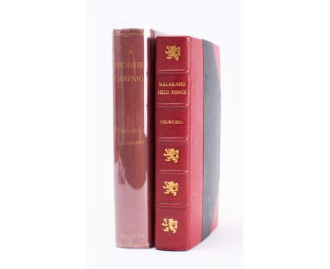
CHURCHILL, Winston Spencer - The Story of the Malakand Field Force an Episode of Frontier War : frontispiece, 2 fold maps, 4 sketch maps, well rebound in half morocco,8vo,1899 reprint from the Colonial Library Edition. * bound by Bayntun-Riviere.With - Fincastle, Viscount * Eliott-Lockhart, P. C. A Frontier Campaign a narrative of the operations of the Malakand and Buner Field Forces, 1897-1898. Fold map, 16 plates, org. cloth, 8vo, 1898.(2)

-
109182 item(s)/page