We found 109182 price guide item(s) matching your search

Refine your search

Year

Filter by Price Range
  • List
  • Grid
  • 109182 item(s)
    /page

Lot 319

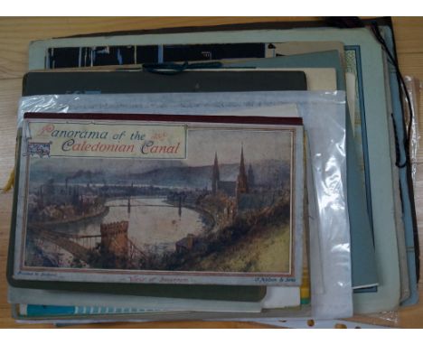
CANALS: 'Offical Opening of the Hatton Locks, Warwick, by H.R.H. The Duke of Kent..'; 30 October 1934. Official brochure of the event, oblong 4to in printed paper wrapper string-tied to spine, some light spotting/marking and wear; 'The Regents Canal & Dock Co..'; promotional brochure of 36 p.p. with folding map, oblong 8vo in printed wrappers, light spots and marks else VG; together with approx. seventeen others, mostly pamphlets and booklets relating to British canals and waterways, to include 'Panorama of the Caledonian Canal..', pub. Nelson & Sons, circa 1905. (Approx. 20)

Lot 320

CANAL MAPS: SHAWE (W.): 'Philips' New Map of England & Wales. Compiled from the Ordnance Survey Showing Canals, Navigable Rivers, Principal Railway Lines..'; London & Liverpool, George Philip & Son, circa 1900, folding colour litho map, printed on paper and laid onto linen, dissected into forty sections and contained in orig. pub. purple cloth slip case, with printed label to one side; together with eighteen others, British and European folding canal maps, mostly later 19th/early 20th century. (19)

Lot 321

CANAL MAPS: JEBB (G.R., Engineer): 'Map Showing Those Portions of the Mineral Districts of South Staffordshire, East Worcestershire and North Warwickshire, Intersected by the Birmingham Canal Navigations..'; folding col. litho map, printed on paper and laid onto linen, dissected into fifteen sections and folding down into orig. black morocco boards, the upper gilt-lettered, boards a little bowed and rubbed, a few minor marks, else good; 'Plan of the Aire & Calder Navigation, and navigations in Connection..'; folding hand-coloured map, circa 1880, printed on paper and laid onto linen, dissected into twelve sections and folding down into burgundy morocco boards lettered in gilt, upper board with attribution to 'W. W. Warde-Aldman', some minor wear to extrems, else VG; together with four other similar folding maps, two of the Grand Union, one of the Shropshire Union and the other of the Grand Junction (Leicester to Norton). (6)

Lot 322

ANDREWS (John): 'Andrews' Map of the Navigable Canals & Rivers of England and Wales, from Actual Surveys..'; London, John Andrews, 1788. Folding copper-engraved map hand-coloured in outline, printed on paper and laid onto linen, dissected into twenty sections and contained in orig. marbled paper covered slip case, printed label of John Andrews to one side, the latter rather rubbed and scuffed, some light browning and marking else G/VG, size unfolded approx. 1520 x 710mm. (1) Condition Report: Andrews map ;lot 322, size 1520 x 710 mm, light browning and marking, elsewhere very good.

Lot 323

BRADSHAW (George): 'G. Bradshaw's Map of Canals, Navigable Rivers, Railways & c. in the Southern Counties of England from Actual Survey Shewing the Heights of the Pools on the Lines of Navigation also the Planes on the Railways from a Level of 6t.10in. Under the Old Dock Still at Liverpool, Dedicated by Permission to Thomas Telford..'; (Manchester, 1830); folding copper-engraved map with contemp. hand-colouring, printed on paper and laid onto linen, each sheet dissected into sixteen sections and measuring approx. 650 x 960mm, some browning and foxing, contained in orig. calf box with morocco gilt label, rubbed and scuffed. (1)

Lot 324

SMITH (C.S., Map Maker): 'Smith's New Map of the Navigable Canals and Rivers of England, Wales & Scotland, Distinctly Shewing the Length of Each Line and the Dates of the Acts of Parliament which have Passed for Executing the Same..'; London, printed for C. S. Smith, 1830. Folding copper-engraved map, hand-coloured in outline, printed on paper and laid onto linen, dissected into thirty sections and folding into orig. green cloth covered slip case, oval printed paper title label to one side, some light spotting and offsetting else VG; together with three other 19th century canal maps, to include: a large manuscript plan of the docks and warehousing at Stourport on waxed paper measuring approx. 1140 x 890mm, folding down into cloth boards. (4)

Lot 341A

RAILWAY MAPS: A group of thirteen rolled railway maps, mostly early 20th century pub. Railway Clearing House; together with a large map of the London & York Railway Routes, pub. 1845, distance tables upper right, laid onto linen and folded, some browning and fraying. (Quantity: one carton)

Lot 345

RAILWAY MAP: BRADSHAW (George): 'Bradshaw's Map of the Railways, Canals, Navigable Rivers & Mineral Districts of Great Britain, Reduced from the Ordnance Survey, Shewing All the Railway Junctions, Stations & c., also the Lines on which the Electric Telegraph is Laid Down..'; London, W. J. Adams, n.d. (circa 1860), folding engraved map hand-coloured in outline, printed onto paper and laid down on linen, two sheets dissected into forty two sections and measuring approx. 1660 x 980mm, contained in modern grey cloth-covered case preserving the original gilt titled burgundy morocco panel to one side, some light browning and offsetting to the map, otherwise good. (1) Condition Report: map very good, light toning and a few minor marks, a few smudges to reverse, case scuffed.

Lot 346

RAILWAY MAP: SIMMONS (J.L.A., Captain): 'Map of England and Wales, Shewing the Railways, Canals & Inland Navigation, Compiled from the Ordnance Surveys and Other Sources. For the Use of the Lords of the Committee of Privy Council for Trade & c...'; large folding engraved map in forty eight sections, hand-coloured in outline, printed on paper and laid onto linen, contained in original black morocco slip case, gilt lettered to spine and one face, the case rubbed and scuffed and lacking the lid, map in VG plus condition with a few minor spots and marks. (1)

Lot 347

DORKING, BRIGHTON & ARUNDEL ATMOSPHERIC RAILWAY: A large folding twenty four sheet map from the Ordnance Survey printed by Ramshaw circa 1845-50, showing proposed route of the railway added by hand in red and blue ink. Large steel engraved map measuring approx. 1850 x 950mm, folding down into period green cloth slip case with burgundy morocco gilt label to one side titled 'Dorking, Brighton & Arundel Atmospheric Railway..', slip case scuffed and frayed with a few ink splats, some foxing and browning to map but condition otherwise generally sound. (1)

Lot 559

COMMERCIAL AIRLINES, EUROPEAN: A collection of twelve brochures and advertising items for European airlines, largely 1930s-50s period, to include brochures for: Sabena; Lufthansa; Air France; Imperial Airways; etc. and to include an original B.E.A. tea towel showing map of international air routes; together with a K.L.M. promotional brochure and show card. (12)

Lot 570

SCHNEIDER TROPHY ARCHIVE: A wide-ranging collection of material relating to the Schneider Trophy, to include: a loose leaf album containing seventy seven period black and white press photographs of scenes around Calshot at the Schneider Trophy event over various years, late 1920s-early 1930s: many images annotated in pencil or with type-written captions affixed to versos, extracts of various contemporary periodicals inserted at rear with articles reporting the event and including some of the photographic images present; rare Official Programme for the Schneider Trophy Race held at Bournemouth on Wednesday September 10 1919 (this race was won by the Italian team in foggy conditions: they were later disqualified and the race was declared void); Gloster Aircraft Magazine, Christmas number for Jan.-Feb. 1927, with Schneider Cup Race Review; Southern Railway brochure advertising rates to Schneider Trophy event (1929?); 'Midnight Cabaret Programme for White Star Line Ship Homeric..', for the 1931 Schneider Trophy Contest; a second Southern Railway Schneider Cup Trains Timetable for 1931; Official Souvenir Programmes for the years 1929 and 1931, both issued by Gale & Polden; Royal Aero Club Schneider Seaplane Race Map, with course over-printed onto conventional sea chart in red, green and blue; two commemorative reports published by 'Flight' magazine; Royal Aero Club Schneider Cup Victory Banquet Ticket, 1927; 1929 Schneider Trophy Race Postcard, postmarked aboard the 'R.M.S. Arcadean' and dated 11 September 1929, printed results form on reverse with manuscript entries; miscellaneous other related periodicals and pamphlets; to also include: three volumes of the Official Air Ministry Aeronautical Research Committee Reports and Memoranda on the Schneider Trophy Contests for the years 1927 and 1931 (two copies). (Small quantity)

Lot 674

MAPS: Three large cartons of maps, largely later folding Ordnance Survey Maps but to include two sheets (of four) from a large format Stanford's Library Map of London & Suburbs; and some other earlier material; to also include a large framed sea chart of the approaches to the River Clyde. (Quantity: three cartons)

Lot 82

FOLDING MAPS: 'A New Map of the County of Sussex Divided Into Rapes & Hundreds..'; London, printed for C. Smith, 1827. Hand coloured copper engraved map, printed on paper and dissected into twelve sections, laid onto linen and folding into orig. blue cloth slip case, rubbed to extrems; together with approx. forty seven other maps, most folding, largely 19th or early 20th century, to include: Sydney Hawes' 'Travelling Atlas of the English Counties', with contents loose. (A carton)

Lot 332

An Antique Town Map Of Beaumaris

Lot 391

An Antique Coloured Map Of North Wales

Lot 473

Two Early 20th Century Sectional Nine Drawer Map Chests

Lot 1310

WWII Military Interest. Silver Plated Brass Tankard The Front Engraved Map Depicting Various Battles With Text. Engraved 'Brass Used For The Manufacture Of This Tankard Was Salvaged From The Battlefields Of North Africa'

Lot 47

Pratts Oil Pratts High Test Map of the Great North Road, colour map of the road between Newcastle and London, by A.E. Taylor in 1930, framed and glazed

Lot 60

Midland Railway Advertising Poster with 16 monochrome images of destination towns and cities surrounding a central oval with a map of the UK rail network served by the Midland Railway; titled 'Midland Railway Direct Route Between Principal Towns Of Great Britain & North Of Ireland'; green ground with red scrolling in original wooden frame with MR monogram boarder overall 40.5x50.5'' (103x128cm) (G)

Lot 466

A large 19th century hand coloured engraved map of Hampshire, by Thomas Dix, 50 x 44 cm, together with an early 19th century hand coloured map of Devonshire by T. Kitchin, 22 x 19 cm. (2)

Lot 267

J Roper, after, a map, Cardiganshire, framed; coloured engravings, Harlech Castle; Beddgelert; etc (4)

Lot 95

Decorative Prints - a reproduction map of Derbyshire; Summer flowers; etc qty

Lot 397

Various prints including a map 'The Island Of Antego by Herman Moll', black and white prints Views of Pyramids and Greek Temples, also Thebes Karnak etc (8).

Lot 379

H. MOLL - THE SOUTH PART OF GREAT BRITAIN CALLED ENGLAND AND WALES, DOUBLE PAGE ENGRAVED MAP, 1710

Lot 410

WWII Period Map of Northern France (Normandy province) mounted on fabric made by Carte Guides, in excellent condition, comes with a small 1930's guide to Munich with its original inserts and a small vintage suitcase.

Lot 267

ROBERT MORDEN; Hand Coloured Map of Cumberland, 14 1/2" (37cms) x 16 1/2" (42cms), the reverse of the frame inscribed "1695".

Lot 268

HERMAN MOLL; a Hand Coloured Map "Westmorland", 7 1/2" (19cms) x 10" (25cms), and a 19th century Map of the East Riding of Yorkshire.

Lot 269

JOHN OGILBY; a Hand Coloured Strip Map of the roads from York to Whitby and Scarborough, 13" (33cms) x 17 1/2" (44cms).

Lot 270

J CARY; a Hand Coloured Map of the North Riding of Yorkshire, published 1803, 16" (41cms) x 29" (74cms).

Lot 1048

Modern reproduction Blaeu Wall map of the world

Lot 529

Group of small furnishing pictures, Langley's new map of Glamorganshire, framed V.E Day tapestry, costume study etc. Framed. (5)

Lot 287

Falkland Islands Dependencies. 1946 1d Thick Map unmounted mint block of eighteen, R3/9 'extra island' and other (minor) varieties. SG G2aa (£170)/CW 34B

Lot 288

Falkland Islands Dependencies. 1946 1d Thick Map fine used, Pl. 1 R1/2 missing 'I'. SG G2b (£190)/CW 34C

Lot 289

Falkland Islands Dependencies. 1946 1d Thick Map unmounted mint block of eighteen, R4/6 'extra dot by oval' and other (minor) varieties. SG G2d (£170)/CW 34E

Lot 290

Falkland Islands Dependencies. 1946 2d Thick Map unmounted mint block of four, top left stamp with Pl. 1 R3/9 'extra island'. SG G3aa (£325)/CW 35B

Lot 291

Falkland Islands Dependencies. 1946 2d Thick Map unmounted mint, Pl. 1 R1/2 missing 'I', top marginal. SG G3b (£300)/CW 35C

Lot 292

Falkland Islands Dependencies. 1946 2d Thick Map unmounted mint, Pl. 1 R4/6 'extra dot by oval'. SG G3d (£325)/CW 35E

Lot 293

Falkland Islands Dependencies. 1946 3d Thick Map unmounted mint block of four, top left stamp with Pl. 1 R3/9 'extra island'. SG G4aa (£225)/CW 36B

Lot 294

Falkland Islands Dependencies. 1946 3d Thick Map unmounted mint, Pl. 1 R3/9 'extra island'. SG G4aa (£225)/CW 36B

Lot 295

Falkland Islands Dependencies. 1946 3d Thick Map fine used, Pl. 1 R1/2 missing 'I'. SG G4b (£300)/CW 36C

Lot 296

Falkland Islands Dependencies. 1946 3d Thick Map unmounted mint block of four, lower right stamp with Pl. 1 R4/6 'extra dot by oval'. SG G4d (£225)/CW 36E

Lot 297

Falkland Islands Dependencies. 1946 6d Thick Map unmounted mint block of four, the ochre shade, top left stamp with Pl. 1 R3/9 'extra island'. A difficult multiple. SG G6, G6eaa (£865)/CW 38a, 38aB

Lot 298

Falkland Islands Dependencies. 1946 6d Thick Map fine used, Pl. 1 R3/9 'extra island', light violet South Georgia CDS. SG G6aa (£325)/CW 38B

Lot 299

Falkland Islands Dependencies. 1946 6d Thick Map with Pl. 1 R4/6 'extra dot by oval', fine used. SG G6d (£325)/CW 38E

Lot 300

Falkland Islands Dependencies. 1948 2d Thin Map, lightly hinged mint with variety 'map double'. Rare. SG G11 (see footnote)/CW 43a (£1200)

Lot 43

A Coffee Table with Map of The World Decorated Top.

Lot 539

A cased 19th/20th Charles Baker brass and ebonised map drawing rule

Lot 626

'The History of Waltham Abbey,1735' by J Farmer with fold-out map intact

Lot 270

A collection of WWII and later British uniforms To include Great coat, battle blouse and trousers, jacket, waterproof capes (2), beret size 7½ and a further size 6 7/8, water bottle, various amounts of webbing, knap sacks, map boards, belts etc, ideal for reenactment groups. (illustrated)

Lot 237

1907 Bartholomew's New Map of Central & South Africa, and SA news paper clipping dated

Lot 113

Large f/g Admiralty map River Thames Margaret Ness to Tower Bridge marked Hydro Graphic Office c. 1980's frame size 47ins W x 29ins H

Lot 135

A framed coloured map of Lancaster as printed by John Bartholomew & Son Ltd, Edinburgh.

Lot 445

19thC Scroll Map of Huntingdonshire

Lot 184

London and South Western Railway Boardroom map and prints, this important piece was purchased from Clapham Railway museum and was believed to have hung in the LSWR boardroom at Waterloo, The carved and Gilded frame measures 50 inches x 38 inches and has its original glass, displays a central map of the LSWR system surrounded by views of Trevone Padstow, Boscastle, Tintagel, Bude, Lydford Gorge, Chagford Glen, Budleigh Salterton, Fingle Bridge, Torrington and Lyme Regis. Makers name Photochrom Co Ltd London at the bottom a truly remarkable and historic piece.

Lot 393

GWR Jigsaws a pair 'Cornish Riviera Express' one is the 200 piece version complete with original green marble book case box, GWR pocket map and Holiday Haunts brochure, the other is the earlier 150 piece version complete with Brown label box, 1 piece is a replacement.

Lot 403

John Steven Dews, British b.1941- "Velsheda off the Needles"; colour reproduction print, signed in pencil, bears blindstamp, 58.4x73.2cm: together with a National Geographic Map of North America, 149x115.5cm, a map of the Republic of Venezeula, printed for the bicentennial of the birth of Simon Bolivar, 91x109cm, and a National Geographic Map of the Middle East, 59.5x95.5cm, (4) CONDITION REPORT: dimensions are of sheet visible

Lot 14

BRITISH EMPIRE STAMPS , a duplicated mint range in old time stockbook with mostly U/M stamps. Inc QV Bechuanaland opts, Ceylon opt surcharges, Falkland Is Dep GVI map issue, India & States, Malayan States, Ionian Is, Zanzibar etc. (100s)

Lot 61

AN 18TH CENTURY MAP OF NOTTINGHAMSHIRE by Robert Morden, framed and glazed. Map 1ft 3.5ins x 1ft 2ins.

Loading...Loading...
  • 109182 item(s)
    /page

Recently Viewed Lots