We found 109182 price guide item(s) matching your search

Refine your search

Year

Filter by Price Range
  • List
  • Grid
  • 109182 item(s)
    /page

Lot 1043

A collection of picture and prints to include James Ingham Riley, lake scene, watercolour, 25cm by 37cm, set of four 19th century coloured engravings allegorical of the four seasons F Bartolozzi, printed map of Westmorland, French advertising sign etc. (20)

Lot 148

Probably 17th century coloured map of Glamorganshire. Framed and Glazed. Appears unnamed. (B.P. 24% incl. VAT) 53 x 41 cm approx. Some foxing but no noticeable rips.

Lot 158

A collection of furnishing pictures and prints to include unframed abstract oils on canvas, botanical floral studies, reproduction map etc. (11)(B.P. 24% incl. VAT)

Lot 487

A MID 19TH CENTURY SCHOOLBOY'S HAND DRAWN MAP OF ENGLAND, and a quantity of pictures and prints

Lot 496

PETER TOMS: 'WATER'S EDGE', WATERCOLOUR an antiquarian map of Mallorca,and a further quantity of pictures and prints

Lot 147

An 18th Century Framed Map of Dorchester based on Actual Surveys and Records of the Country by J Bayly 1773, 70x52cm

Lot 100

A framed reproduction map of North and East Ridings of Yorkshire in the seventeenth century 53 cm x 51 cm. CONDITION REPORT: This is very dark and stained, probably 20th century and not earlier.

Lot 101

A framed map of the British Isles and Ireland CONDITION REPORT: This is not on wove paper.

Lot 470

A framed continental map and six Hogarth framed colour etchings of Hexham and Northumberland

Lot 532

An antiquarian hand coloured framed map of Northumberland

Lot 98

An Edwardian oak framed print after Saxton, map of Lincolnshire and Nottinghamshire in 1576

Lot 99

A framed colour map of Lincolnshire and another of the British Isles (2)

Lot 623

Antique hand coloured map of Surrey by Cary, 15.5ins x 18.75ins, framed

Lot 655

Framed antique hand coloured map of Norfolk by Blome, 9.5ins x 12.75ins

Lot 755

Framed antique hand coloured map of ' Hantonia ' (Hampshire), 16ins x 19.75ins, framed

Lot 787

Framed antique hand coloured map of the Hundred of Bromley and Beckenham and the Hundred of Ruxley, 15ins x 14ins, together with a framed black and white map of Lewes, Chichester and Brighthelmstone

Lot 796

Group of four unframed coloured engravings, ' The First Steeplechase on Record ' after Alken (at fault) together with a 1977 Spithead map, a reproduction map of London and a 20th Century coloured print of fish

Lot 820

17th Century John O'Gilby hand coloured map of the road from Chester to Cardiff, maplewood framed, 14ins x 17.5ins

Lot 430U

A mahogany map of the world nest of tables

Lot 554

A Sir David Young Cameron etching, continental riverside town, framed and a Cheshire Ring map

Lot 566

A Health Service Journal Map of Great Britain, framed

Lot 565

THREE BOXES AND LOOSE SINGLES, LPs, JIGSAWS, WAR MAGAZINES, SOFT TOYS, DVDS AND SUNDRIES, etc including a boxed Laura Ashley plastic collectors doll, five modern teddy bears including Keel Toys, M & S and John Lewis, Friends dvds series 2, 3 & 4, unused gardening gloves, Waddington's Jig-Map puzzles, etc (three boxes and loose)

Lot 656

POSTCARDS, a collection of over three hundred and seventy five postcards in one album and loose featuring early 20th Century vistas of topographical scenes, landmarks, cities and personnel, the cards are mainly European (Switzerland, France, Italy, Belgium, Holland and Great Britiain) the lot also includes a Times Millennium Edition, 1st January 2000 with certificate of authenticity and a Bartholomew's ½'' contoured map of Dorset (two boxes)

Lot 780

LONDON UNDERGROUND POSTERS, eight London Underground Information/Advertising posters from the 1990's, laminated, dimensions approximately 102cm x 63cm and one London Underground London Connections Map from 1999, laminated, dimensions approximately 126cm x 115cm (9)

Lot 203

Assorted Rum, to include Ron Bacardi Superior, Carta Blanca Rum, old bottling, 40% vol, 1.14 litre, one bottle; Bacardi Superior, Carta Blanca Rum, old bottling, 37.5% vol, 100cl, one bottle; Ron Bacardi Superior, Puerto Rican Rum, old bottling, 151 proof/75.5% vol, 1.14 litre, one bottle; Ron Bacardi Limon, Original Citrus Rum, 35% vol, 1 litre, one bottle in plastic box; Fine Barbados Golden Rum, bottled for Caribbean Basin MFG, 43% vol, 1 litre, in map shaped decanter, one bottle and Rivers, Royale Grenadian Rum, 69% vol, 75cl, one bottle, six bottles in total

Lot 170

Four WW2 military maps, three Second war editions all dated 1940, depicting Colchester, Southend & District and N.E London & Epping Forest, and a military edition map of East Anglia dated 1939 (4)

Lot 51

The Autocar map for motorists England & Wales, on card sections

Lot 325

1973 OSSA MAR, 244 cc, project. Registration number NGV 80M (see text). Frame number not found. Engine number  M343929. In a bid to emulate the competition successes of rivals Bultaco and Montesa, Ossa hired English trials star Mick Andrews in 1967. Then only 23 but already a proven winner, Andrews set about developing Ossa's existing trail bike into a competitive trials mount, a process that culminated in the MAR - Mick Andrews Replica - that carried its creator to consecutive European Trials Championships in 1971 and '72. The MAR put Ossa on the trials map with a vengeance and proved so successful that it remained in production until the late 1970s. A potentially competitive mount for classic 'twin-shock' trials events, this un-restored Ossa MAR was last on the road in 1995. There is no paperwork with this project, but it is recorded with DVLA. Sold with a different rear cog and a few spares.

Lot 437

A framed map of the World97x67cm

Lot 1115

'Coast North of Flamborough Head', large 19th century map pub. James Imray & Son 1892, 119cm x 197cm (unframed)Click here to view further images, condition reports, sale times & delivery costs for this lot.

Lot 1117

Theophilus Jones (British 19th century): 'Brecknockshire' Wales, early 19th century hand-coloured map pub. 1806, 60cm x 45cmClick here to view further images, condition reports, sale times & delivery costs for this lot.

Lot 1118

Joan Blaeu (Dutch 1596-1673): Cheshire - 'Cestria Comitatus Palatinus', engraved map with later hand colouring pub. 1648, 42cm x 53cmClick here to view further images, condition reports, sale times & delivery costs for this lot.

Lot 1119

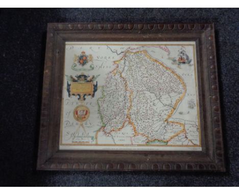
John Stockdale (British 1749-1814): 'Great Britain and Ireland with ye Judges Circuits', engraved map with triangular distance chart titled 'Distances of the Cities & Shire Towns in England & Wales' pub. 1805, 37cm x 48cmClick here to view further images, condition reports, sale times & delivery costs for this lot.
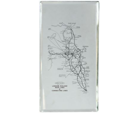
Lot 106

A Goodyear tin map of the UK, 91 x 69 cm.

Lot 1040

After J.D Harding - Pair; Hunstanton Hall, Norfolk, reproduction mezzotints, each 22 x 35cm; together with a framed town plan map of Hunstanton (3)

Lot 1075

Greta Hansen - Fishing boats at low-tide, watercolour, signed lower right, 19 x 29cm; David Green - Waldringfield; and a late 18th century French provincial map (3)

Lot 1080

A Dutch 1:10,000,000 scale map of the continent of Africa, being canvas backed; together with sundry prints etc

Lot 1085

Sundry pictures and prints, to include map of Horringer Road in Bury St Edmunds circa 1883, woolwork etc

Lot 1116

Maria Poole - Chalk rocks, lithograph, 16 x 23cm; John Carey - Engraved county map of Norfolk; and an etching of Custom House, Kings Lynn (3)

Lot 427

A group of paintings and prints to include landscapes dog picture map of Salisbury etc.

Lot 46

An 18th century hand tinted double sided map by John Ogilby (1600-1676) - The Road From London to Barnstable - framed, approx 21 by 17cms (8.25 by 6.7ins).

Lot 877

A 20th century reprint of a 16th century hand tinted map of Lancashire; together with other prints.

Lot 997

An original 1930s Pratts Motor Oil paper map Plan of The North Moor, Mountain and Lake District. 38cms (15ins) by 50.5cms (19.875ins)

Lot 1000

A rare 1938 London Underground railway map No.1 by H.C.Beck, together with a 1949 Paris et sa Banlieue par les Autobus et le Metro (Paris and its suburbs Bus & Underground) R.A.T.P. map, another French map of Poitiers Shooting Range and Booklets V & X of the Milestone Guides

Lot 471

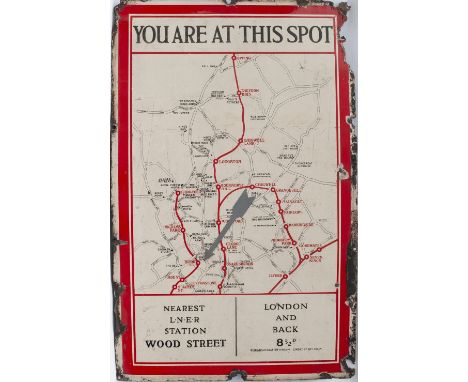
LNER enamel sign circa 1920's headed YOU ARE AT THIS SPOT showing a local map of the area and lines to Chingford, Epping, Seven Kings and Chigwell. A large grey arrow is pointing to The Rising Sun Public House the bottom of the sign says NEAREST LNER STATION WOOD STREET and LONDON AND BACK 8D. Interestingly, a good number of local pubs are shown including Theydon Retreat, Grays Retreat and The Volunteer. In good condition with some edge loss measures 29in x 39in.

Lot 578

BR(M) advertising mirror LONDON MIDLAND MAIN LINES & CONNECTING LINES. Shows a map of the lines out of Euston, St Pancras and Marylebone all the way up to Carlisle. Thick bevelled mirror glass measuring 11in x 6in. In excellent condition with a minor chip bottom right hand corner.

Lot 771

London Transport NORTHERN LINE melamine map, circa pre 1972, as used in the Underground stock. Manufactured by Leonard Ripley, in very good condition, measures 55in x 6.5in.

Lot 48

Three maps pertaining to Hampshire including one after Robert Morden, hand-tinted, 36 by 42cms, another after Emanuel Bowen, detailed and with hand-tinting, printed for Parker and Bowles Cornhill, 41 by 51cms, and a road strip map after John Ogilby from London to Southampton, 33 by 44cms (3) Condition Report: First- paper has browned and colours faded, dealers label dating map to 1695 and priced at £220 Second- fair- some browning- colours muted, dealers label dating map to 1762 and priced at £345 Third- browned- paper cockling- dealers label dating map to 1675 and priced at £275   Condition Report Disclaimer
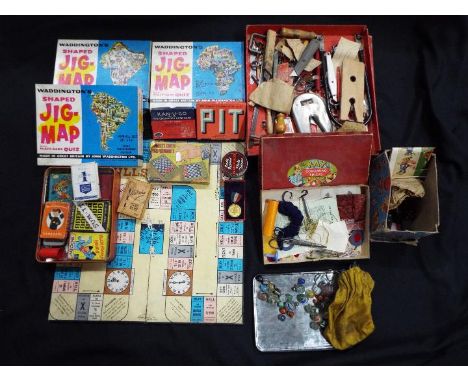
Lot 861

Waddington's - A collection of vintage games, puzzles and toys. Lot includes Waddington's Shaped Jig-Map #426 India, plus #422 Africa and #424 South American Continent; with a selection of vintage playing cards; Snap; Belisha Card Game, Dominoes; a small quantity of marbles; and a 'Foreign' marked Fretsaw Saw with a selection of vintage and modern tools. All items are in Playworn condition and are unchecked for completeness.
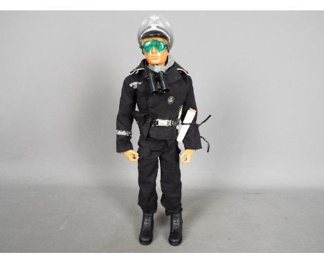
Lot 940

Action Man, Palitoy - An unboxed Palitoy Action Man 'Panzer Commander'. The blond flock hair Action Man has Eagle Eyes, gripping hands and dynamic 'muscle' body in blue trunks marked 'CPG Products 1978' to back. The figure is wearing Black Panzer Captain jacket and tunic, with belt, holster, Luger, grey scarf, cap, goggles, binoculars, short boots, and map with 'home made map holder). The figure appears to be in Excellent condition.

Lot 1338

Polaroid, Minolta, Pentax and Olympus Cameras, magnifying glass, Salter scale, model book, Cunard Caribbean map, etc:- One Tray

Lot 1397

Framed Indenture on Velum, Monmouth map, 'Thos Kitchin' with Monmouth to Lanbeder Road, in single frame; and one other. (3)

Lot 144

WW2 British RAF Silk Escape map K5/K6 covering Nigeria, Cameroon etc.

Lot 145

WW2 British RAF Silk Escape & Evasion map sheet 43/D covering France & Germany

Lot 146

WW2 British RAF Silk Escape & Evasion map covering Nagasaki and Kagoshima, second edition 1944.

Lot 147

WW2 British RAF Silk Escape & Evasion map covering Southern Italy & Sicily. Singled side map.

Lot 148

WW2 British RAF Silk Escape & Evasion map of the Baltic and Scandinavia.

Lot 149

WW2 USAAF Silk Escape & Evasion map of Luzon and the Philippines no C 40 and No34 South East China.

Lot 150

WW2 British RAF Escape and Evasion Silk Map C/D France & Holland

Loading...Loading...
  • 109182 item(s)
    /page

Recently Viewed Lots