We found 109182 price guide item(s) matching your search
There are 109182 lots that match your search criteria. Subscribe now to get instant access to the full price guide service.
Click here to subscribe- List
- Grid
-
109182 item(s)/page


Lot 472
ROBERT MORDEN, HAND COLOURED MAP OF SUFFOLK SOLD BY ABEL SWALE AWNSHAM & JOHN CHURCHIL, 14 ¾" (37.5cm) x 17 ¼" (44cm) together with A MODERN MAP OF WORCESTERSHIRE printed for Carrington Bowles 10 ¼" (26cm) x 8" (20.3cm) and A MAP OF SHROPSHIRE, engraved for J. HARRIFON 13 ¾" (35cm) x 18 ¼" (46.3cm) (3)


![Abraham Ortelius, 'Regionis Biturigum Exactiss [with] Limaniae Topographia' and three other framed maps, comprising another O](https://cdn.globalauctionplatform.com/a4d89b6e-c02d-404f-8445-a93d00a321cf/580311ec-f9fc-41b2-9127-6b9bbcc5250f/468x382.jpg)
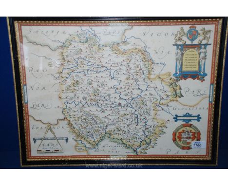
Lot 377
Abraham Ortelius, 'Regionis Biturigum Exactiss [with] Limaniae Topographia' and three other framed maps, comprising another Ortelius double map on single folio sheet, 'Calais and Vermandois, France and Vicinity' (uncoloured), an Ortelius map of 'Gallia Vetus' and a John Speed map of Northamptonshire (faults)


Lot 329
A collection of 18th century and later engravings of French topographical views, including Richard Phillips, 'South View of the Old and New Louvre...' (1803), Jean-Baptist Rigaud, 'View of the Canal of Fontainebleau' and 'A General View of the City of Paris' (1749), 'Vue du Chateau Royal du Chambord...' and 'Vue des ecuries de Versailles prise de la Seconde Grille' and four others (all framed, 5 later coloured), together with an 1855 map of Paris (10)


Lot 1075
A collection of prints of the Napoleonic period including: Baines, Edward (publisher) c.20 engraved maps, scenes and portraits from his History of the Wars of the French Revolution published between 1814-1817, some framed, various sizes. Baines (1774-1848) was proprietor of the Leeds Mercury and a determined political commentator, whom William Cobbett called 'the Great Liar of the North'. His History was initially offered in parts, starting in 1814. It would be unlikely many would have anticipated the dramatic return of l'Empereur, making this work one of the first contemporary histories of the war - having not actually finished yet. This discrepancy of dates (some plates before the return, some during the final year, and some from the immediate period after) makes the subjects especially interesting. One of the 1814 plates is a map of the French Empire, showing the heights reached, where one of the latest (1817) is Napoleon's final surrender on Bellerophon. Boussod, Valadon & Cie. (publishers) 5 coloured lithographs, framed, various sizes, late 19thc (post 1884 when Groupil & Cie became Boussod, Valadon & Cie). The publishers were major art dealers in late-19th century Paris. Their core business was the creation and sale of reproductions such as these, but they also sold original works by artists such as Bouguereau, Monet and Corot. The firm played a part in the story of Van Gogh as his uncle Vincent was a partner from 1861 till retirement in 1872, and his cousin Theo joined the firm in 1873. Van Gogh himself worked for them for 6 years in their offices in The Hague, London and Paris until they dismissed him after an unauthorised Christmass absence. With 2 other framed, coloured Napoleonic prints and some others. [Qty]


Lot 2264
Hermès Citrus Fruits Silk Scarf, by Valerie Dawlat-Dumoulin, printed with a design of lemons and oranges upon a wooden stand, on a green ground, 90cm square, with original box; together with a Hanae Mori Dark Blue Silk Scarf, printed with contrasting blue birds and a striped border, 8cm square, with original card packaging; and an Alviero Martini la Classe Silk Scarf, printed with a map, 50cm square, with original retail tag attached (3)


-
109182 item(s)/page