We found 109198 price guide item(s) matching your search
There are 109198 lots that match your search criteria. Subscribe now to get instant access to the full price guide service.
Click here to subscribe- List
- Grid
-
109198 item(s)/page


![[Railway] L.M.S Scottish Division Aberdeen South train line 1"" = 33 ft scale map](https://cdn.globalauctionplatform.com/26d56b34-7179-4058-a077-a7f600981693/3f97f044-9e65-48cf-da8f-f5caeaa78629/468x382.jpg)


Lot 382
ATTRACTIVE COLLECTION OF FORTY-NINE WELL SET BUTTERFLIES, EX. FRANCE, to include Scarce Swallowtail, Silver Washed Fritillary, Red Admiral, Painted Lady, Large Tortoiseshell, Comma, Blues, Map .... etc., five additions without data. Mostly EX. COLL. DAVID KENINGALE. Full data, presented in early wooden store box CL07/2015/0003 (butterflies)


Lot 267
AFTER W ALEXANDER "To The Rt. Hon Lord Romney Lord Lieutenant of the County of Kent This representation of the dinner given by His Lordship to the Kentish Volunteers in the presence of Their Majesties and The Royal Family", colour print, together with a plan of the tables for The Volunteers of Kent Dinner, map verso, together with various other prints and engravings
![Three antiquarian travel books: 'The General History of China', P. Du Halde, 1 [of 4], London: J. Watts, 1741, octavo leather](https://cdn.globalauctionplatform.com/41559025-4aa1-4836-8a44-a7ee00cd8412/74048675-572e-4e7f-e4b0-9c792af08cdd/468x382.jpg)
Lot 859
Three antiquarian travel books: 'The General History of China', P. Du Halde, 1 [of 4], London: J. Watts, 1741, octavo leather binding. Together with two editions of George Sandys' 'Relation of a Journey Begun Anno Domini 1610': a 5th edition printed in London by John Sweting, 1652 (featuring map of Middle East), the other undated but 17th-century; both quarto leather bindings. a/f (3)

Lot 885
A large Queen Anne map of Europe by Herman Moll, 1708: copper engraving on laid/chain-lined paper with hand-coloured outlines, decorative cartouche with portrait of Queen Anne and figures displaying native fashions. Bearing dedication 'to Her most sacred Majesty Ann Queen of Great Britain, France & Ireland'. Printed for Bowles, London, 1708; sold by H. Moll & P. Overton.

Lot 886
A collection of six antique maps, Warwickshire interest: Joan Blaeu, original 17th-century map of Worcestershire & Warwickshire, hand-coloured copper engraving on laid/chain-lined paper. A handsome antique map, rich impression, featuring decorative cartouche and armorial shields. Mounted, framed and glazed. 1645 or later. Good and bright, unexamined out of frame but doesn't appear to have been stuck down. Together with John Speed, original 17th-century map of the county of Warwickshire. Hand-coloured copper engraving on laid/chain-lined paper, sold by John Sudbury & George Humble. A decorative map featuring armorial shields and inset plans of Coventry and Warwick. Framed & glazed. Age toning, some early inscriptions/marks in ink, discolouration from tape reinforcing the vertical fold; unexamined out of frame. Plus another four antique maps of Warwickshire: Kip after Saxton; miniature John Speed; Owen & Bowen road map (Oxford to Coventry); John Seller. (6)

Lot 858
India/Travel interest: 'Observations on the Neilgherries, including an account of their Topography, Climate, Soil & Productions, and of the Effects of the Climate on the European Constitution: with Maps of the Hills and the approaches to them, Sketches of the Scenery, Drawings of the Principal Buildings, Tables of Routes, &c.', by R. Baikie, edited by W. H. Smoult, Calcutta: 1834. 11 lithographic plates, 10 of which hand-coloured; large folding engraved map; 33 smaller maps, two of which folding. Octavo, original crude boards.

Lot 883
John Speed, original 17th-century map of Derbyshire: 'Anno Darbieshire described 1610', published by John Sudbury and George Humble. Hand-coloured copper engraving on laid/chain-lined paper bearing manufacturer's watermark (shield/crest), English text to verso, featuring inset town plan of Derby and inset view of Buxton. Framed and glazed to recto and verso.


Lot 889
'Wonderground Map of London Town', MacDonald Gill. Printed and published by The Westminster Press, London. Published c.1924 for the British Empire Exhibition held at Wembley (the map features the Empire Lion and sign 'On To Wembley'). An important piece of British design, very rare to find in this original condition, complete with original envelope (priced Two Shillings and Six Pence). The map was originally commissioned to help save the London Underground and remains an iconic design to this day. 30 by 37 inches.

Lot 857
America/Travel interest: 'Some Information Respecting America, Collected by Thomas Cooper, late of Manchester', London: J. Johnson, 1794. An interesting 18th-century antiquarian book, including fold-out map of 'The Middle States of America' by Thomas Conder (positioned as frontispiece). Octavo half-calf binding, re-backed with original spine laid down, gilt title and date to spine.

Lot 894
A rare 17th-century map of Cornwall by John Speed: John Sudbury and George Humble, Hondius (signature in plate), hand-coloured copper engraving on laid/chain-lined paper bearing manufacturer's watermark; English text to verso. Inset view of Launceston, armorial shields, ships and sea monsters. Framed and glazed to recto and verso. Measures approx. 51.5cm x 39.5cm (mount window).
Lot 882
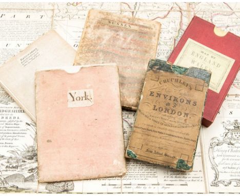
A collection of antique maps: four 18th-century hand-coloured copper engraved maps by Emanuel Bowen (York, Devonshire, Sussex, Cambridgeshire), all linen-backed, two complete with slipcases; Cruchley's Environs of London, 1827, complete in four parts within original slipcase, hand-coloured; Edward Stanford Railway & Road Map of England and Wales, 1877, hand-coloured and linen backed with original slipcase bearing label; and a quantity of Ordnance Survey maps, 1912 and later, including an interesting geological map of Cambridgeshire, plus a few similar folded maps.

Lot 890
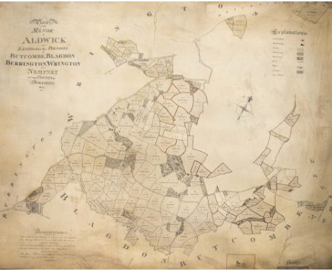
Original Georgian English manuscript estate plan/map for the Manor of Aldwick, Somerset. Entirely hand-drawn in black ink on vellum, with some coloured detail. 'A Plan of the Manor of Aldwick and Lands within the Parishes of Butcombe, Blagdon, Burrington, Wrington and Nempnet in the County of Somerset 1815'. The map features some text about the Baker family, including Samuel Baker (who built Aldwick Court in 1791). A unique map produced during the Regency era, the same year as the Battle of Waterloo. Measures approx. 88cm x 113cm.Note: This Lot is subject to The Manorial Documents Rules 1959, 1963 & 1967 requiring the successful bidder to notify The Secretary of The Commission at National Archives providing details of where it will be kept. In no circumstances can it be removed from England and Wales without prior consent of The Master of the Rolls.


Lot 888
Georg Braun & Frans Hogenberg, late-16th/early-17th century prospect/map of Prague: 'Palatium Imperatorum' and Praga', two panoramas on one sheet, copper engraving on laid/chain-lined paper [1596 or later], in original uncoloured condition. The picture depicts the Imperial Palace in Prague, with figures in contemporary dress/fashion in the foreground. Framed & glazed.


Lot 891
A collection of five antique maps of Somerset: 'Somersettensis Comitatus Vulgo Somersett Shyre Qui olim pars suit Belgarum', early 17th-century copper engraving on laid/chain-lined paper, Saxton & Kip; a large 18th-century 'Improved Map of the County of Somerset' by Emanuel Bowen; two versions of 'A Mapp of the county of Somerset', Richard Blome (one hand-coloured, one uncoloured); 'Somersetshire', Pieter van den Keere ("Miniature Speed"). All framed and glazed. (5)

Lot 823
The Whole Genuine Works of Flavius Josephus, the Learned and Authentic Jewish Historian, and Celebrated Warrior: Translated from the Original Greek', by William Whiston, in four volumes, Glasgow: Blackie, Fullarton, and Co. No date but c.1820s. Four volumes, 8vo half-calf and marbled boards, morocco title labels and gilt lettering, engraved frontispiece to the first volume and a fold-out map to start of other three volumes.


Lot 407
Johannes Blaeu, Huntingdonensis Comitatus, Huntingdonshire, hand coloured engraved map, slightly browned, with margins, 43 x 53cm; John Cary, Cambridgeshire, hand coloured engraved map published 1805, 52cm x 41cm; and John Cary, A Map of Westmoreland from the best authorities, c.1805, 40cm x 49cm Bercheria Vernacule Barkshire, a double-page hand-coloured engraved map, (4)


-
109198 item(s)/page