We found 109182 price guide item(s) matching your search
There are 109182 lots that match your search criteria. Subscribe now to get instant access to the full price guide service.
Click here to subscribe- List
- Grid
-
109182 item(s)/page


Lot 55
Approx 27 assorted poster designs and one calendar. Mostly rolled UK quad posters for assorted 'Brent Walker' adult-orientated titles inc 'Vice Squad', Fanny Hill, New York Nights (multiple copies), The Bitch (multiple folded mini posters) as well as a map of an area of Leeds and a large poster mounted to board for 'The Bitch'.

![Three coloured maps comprising 'The Road from Oxford to Coventry [...]', 'The Road from London to Newhaven [...]' and 'Irelan](https://cdn.globalauctionplatform.com/50ee825f-edc2-4f6d-a716-ad1801140a91/bb4b3b2b-87f5-4e80-8af7-ad1a011ef46f/468x382.jpg)
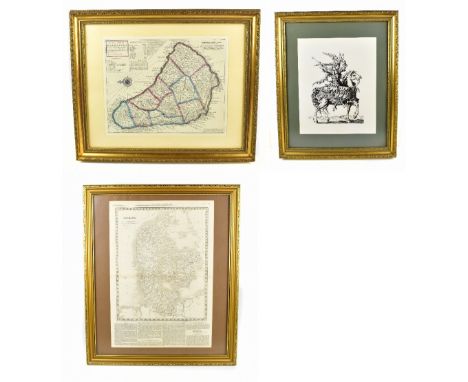
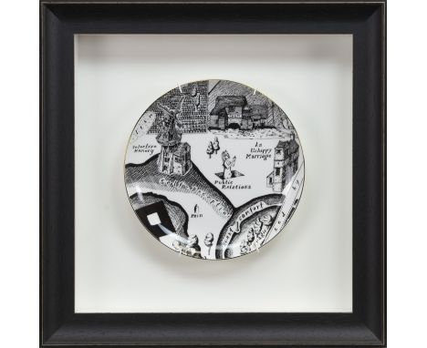
Lot 2004
Three coloured maps comprising 'The Road from Oxford to Coventry [...]', 'The Road from London to Newhaven [...]' and 'Ireland', the latter and largest 27 x 21.5cm, all framed and glazed (3).Additional InformationSome spotting and foxing, yellowing, dirt and discolouration to mounts. The two road map frames heavily worn.


Lot 3205
WEBB (M), THE MAGIC LAMPLIGHTER, illustrated by Margaret Tarrant, with colour plates as per list, map end papers, pictorial paper mounted d.j, beige cloth, Medici Society, 1926; STEVENS (F), THROUGH MERRIE ENGLAND, illustrated by Francis Bedford, with illustrations as per list, clipped d.j., blue cloth, Frederick Warne & Co; FILEMAN (R), THE PRINCESS DANCES, illustrated by Cecil Leslie, with plates as per list, d.j., with pictorial board and cloth spine, Dent & Sons, 1933; WATSON (A), illus, THE KATHLEEN FIDLER OMNIBUS, full page plates and text illustrations, un-clipped d.j., with blue cloth, Collins, reprinted 1950; HALE (K), MANDA, un-clipped d.j., with pictorial boards, John Murray, 1952 (5)


Lot 447
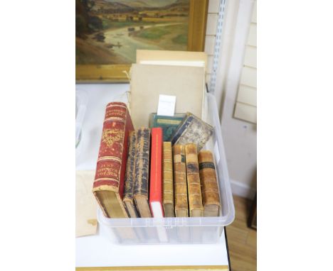
Dickens (Charles), Master Humphrey's Clock, London; Chapman and Hall, 1841, Vols I & II, 1st edition in book form, illustrated George Cattermole and Harlot Browne, ½ calf with marbled boards; John Nichols, A Collection of All The Wills Now Known To Be Extant, of the Kings and Queens of England …, London 1780, 4to, marbled boards, re-backed, T/W Joseph Haydn, Dictionary of Dates, and Universal Reference, …., London: Edward Moxon, 1851, full calf with ribbed spine; A collection of various mid 19th century guide books bound in one volume: to include: The Handbook to Battle Abbey .., Battle; F W Ticehurst, no date, John Bullar, A Historical and Picturesque Guide to the Isle of Wight, London; Simpkin, Marshall & Co, 9th ed, fold-out coloured map, Samuel Phillips, Guide to the Crystal Palace and Parks …, London: Crystal Palace Library and Bradbury and Evans, 1855, fold-out map, et al. All bound in 1 vol, half morocco with marble boards and Exhibition of the Works of Industry of All Nations 1851. Reports by The Juries on The Subjects in the Thirty Classes into which the Exhibition was Divided. London; Spicer Brothers, 1852, Vol III, gilt tooled red morocco with ribbed spine. CONDITION: - Nichols Re-backed


Lot 57
Kelly's Directory of Berkshire Buckinghamshire on Oxfordshire With New Maps 1920 Hardback Book. Published by Kelly's Directories Ltd 476 pages with 84 advert pages - Book is in Worn condition with damage to spine, torn folded Map and foxing to edges. Sold on behalf of the Michael Sobell Cancer Charity. Shipping at cost from £4.99 in UK, we can ship a 30kg box for £10 so up to 10 books. Overseas shipping at cost from £7.99


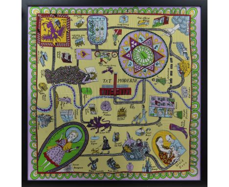
Lot 650
* GRAYSON PERRY RA (BRITISH b. 1960), 100% SILK SCARF 100% silk, produced for the Tate 91cm x 88cm Mounted, framed and under glass. Note: In the second world war pilots were given maps printed on silk to help them escape if they were shot down over enemy territory. This scarf is a social and cultural map to help aspiring artists navigate the hostile territory on their way to being accepted by the establishment. Many famous artists who can help them live along the route
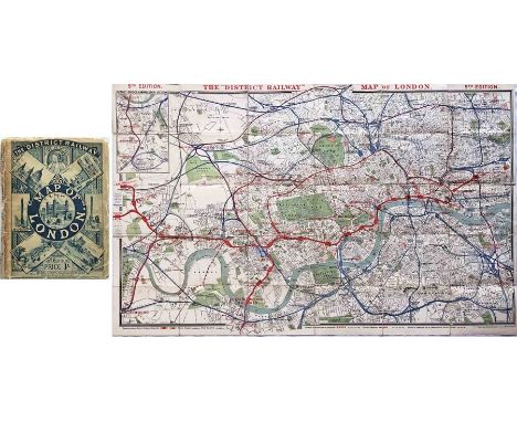
Lot 121
c1892 District Railway Map of London, 5th edition (1st version). It shows the the world's first deep-level tube railway, the C&SLR, open as far as Stockwell with the Clapham extension proposed. Also shows the proposed Regent's Canal, City & Docks Railway and City Lines Railway to Barbican. Linen-backed inside card covers, opens out to 42" x 26" (107cm x 66cm). A well-used copy but the map is generally good. Worn covers with repaired spine and first owner's name on front. [1]
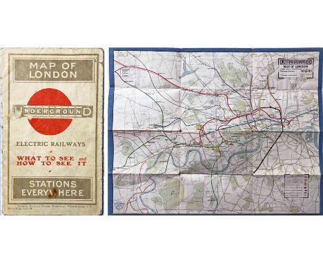
Lot 124
1913 London Underground POCKET MAP 'What to See & How to See it. Stations everywhere'. This is the uncommon issue with print-code 220-139M-7.11.13. Opens out to 14 " x 11" (36cm x 28cm). Shows projected extensions to Ealing Broadway, Queens Park and Edgware as well as the LNWR line to Watford in anticipation of the proposed Bakerloo extension. Cover has one of the first printed 'bar & circle' logos. A very reasonable example in used condition with some cover stains, creasing and fragile folds. [1]

Lot 126
c1850s Carte Generale des Chemins de la France et de l’Allemagne published by Logerot, Paris (map of the railways of France and Germany). Also covers Swiss, Belgian, and parts of Dutch & Italian railways. Opens on paper to 37" x 27" (94 x 69 cm). Colour-coded key to lines plus a key to towns, cities, ferry ports, railways built, railways under construction and projected with an inset map of the Paris region. Red board covers with an image of a very early 2-4-0 loco. Worn covers with reinforced spine, some staining to map which is reinforced on reverse with archival clear tape. [1]
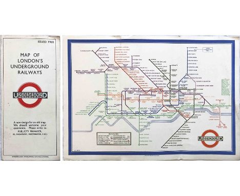
Lot 13
1935 London Underground diagrammatic, card POCKET MAP designed by Henry Beck. This is issue No 1, 1935 (no print-code) and shows the escalator connection between Bank and Monument stations. An excellent copy, crisp and firm. Carries a label on the front showing it was issued by Frames' Tours of London WC1. [1]

Lot 151
1905 MAP of the Electric Railways in the Metropolis and Neighbourhood prepared for the Royal Commission on London Traffic. Shows the railways existing and authorised and those proposed in sessions 1901-1905 with a key to lines constructed, under construction, authorised, proposed and to steam railways electrified. Some colour. On folded paper, opens out to 40" x 30" (102 x 76 cm). A fascinating record. Some ageing but generally in very good condition. [1]
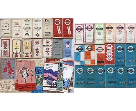
Lot 167
Quantity (50+) of London Transport etc POCKET MAPS & LEAFLETS from 1930s to recently. Includes LCC Tramways 'Parks & Open Spaces', 'Rambles from Cockfosters', Bus & Tram Revised Route Numbers, Bakerloo Line extension, 1937 & 1953 Coronations, Festival of Britain guide and pocket maps, 'London' & 'Welcome' pocket maps, WW2 East Yorkshire bus map (ex-timetable book) etc etc. Mostly in very good condition. [50+]
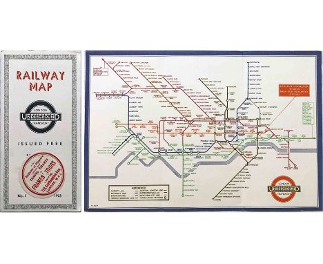
Lot 177
1933 first edition of the H.C. Beck London Underground diagrammatic card POCKET MAP with the famous cover slogan "A new design for an old map....." and print-code 750M - 1-33. A lightly-used example with a few tiny marks, very small bends at the corners and a crease to the rear cover/down the r/h side of the map but overall still in very good condition. [1]
Lot 187
1911 London Underground POCKET MAP. Shows the CLR extension to Liverpool St under construction, the 3 separate Hammersmith stations and the LBSCR lines to Crystal Palace. Opens out to 10.5" x 8" (27cm x 20cm). In excellent condition, an ex-guidebook copy that has a trace of adhesive on the reverse at one edge. [1]
Lot 212
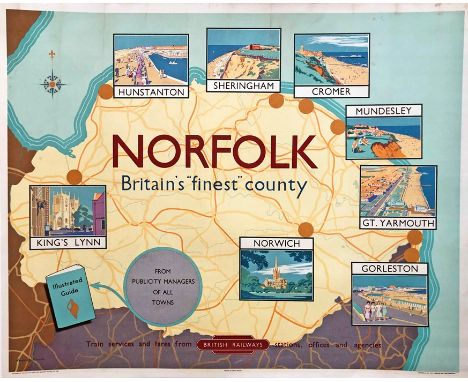
1950s British Railways (Eastern Region) quad-royal POSTER 'Norfolk - Britain's "finest" county' by Lance Cattermole (1898-1992). A colourful depiction of a map of the county onto which are superimposed small illustrations of its principal cities and towns, particularly seaside resorts. Has been professionally mounted onto acid-free conservation paper. Some light stains from the top edge downwards but generally in very good order. [1]

Lot 218
1976 (July) London Underground quad-royal POSTER MAP designed by Paul E Garbutt. Shows the Fleet Line from Baker Street to Trafalgar Square as under construction, the Piccadilly line extension to Heathrow Central as opening in late 1977 and the Northern City Line link from Drayton Park to Finsbury Park as opening in November 1976 . A very good example with a small stain at the top r/h corner (off map) and minor edge-scuffs. [1]

Lot 222
1903 MAP of London prepared for the Royal Commission on London Traffic and showing the 1846 proposed Lines of Railway and Termini referred to in that year's Report of the Royal Commission on Metropolitan Railway Termini and the limits within which the Commission recommended no railway or termini should be permitted. With a colour-coded key to the lines of 15 companies. On folded paper opening out to 32" x 28.5" (82 x 72 cm). Generally in very good condition. [1]
Lot 223
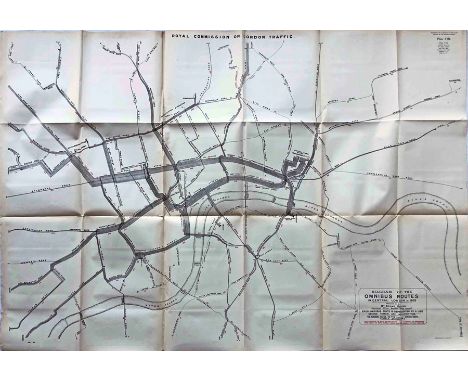
1903 MAP "Diagram of the Omnibus Routes in Central London" for the Royal Commission on London Traffic 1905, prepared by Mr Edgar Harper, Statistical Officer of the London County Council. The routes and termini are shown in black and the number of buses per hour on each route is printed on each section of the routes in red. On folded paper, opens out to 44" x 30" (112 x 76 cm). A most important historical document compiled well before the first public bus maps. In very good condition. [1]


Lot 233
1901 District Railway Map of London, 6th edition. This is the very uncommon 2nd version. It shows the development of the tube railways with the C&SLR and CLR open and the Baker St & Waterloo, the Brompton & Piccadilly and the Hampstead tubes as authorised or under construction. Also shows the proposed Brixton & City and North West London (north along the Edgware Rd from Marble Arch) railways. Linen-backed inside board covers, opens out to 41.5" x 26" (105cm x 66cm). Covers a little worn, the map is very good. [1]
Lot 238
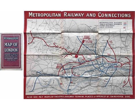
1924 Metropolitan Railway POCKET MAP, the Met's own version of the London Underground map. This is the edition with print-code G.1608.100,000 and is the version with the overprint on the map for the British Empire Exhibition and Cup Final Stadium. A very good example, just lightly used with a few small blemishes. [1]
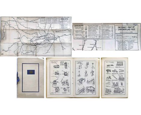
Lot 24
Pair of items by Fred Stingemore (1890-1954) comprising a 1921 DISTANCE MAP OF UNDERGROUND RAILWAYS, linen-backed inside card covers, opens out to 36" x 20" (92cm x 51cm), in very good, used condition plus a 1931 Underground Group Tramways Staff Dinner MENU & PROGRAMME featuring 3 pages of light-hearted cartoons by FHS on the subject of trams & trolleybuses - in very good condition. [2]

-
109182 item(s)/page