We found 109198 price guide item(s) matching your search

Refine your search

Year

Filter by Price Range
  • List
  • Grid
  • 109198 item(s)
    /page

Lot 138

MUIRHEAD GEORGE.  The Birds of Berwickshire. 2 vols. Fldg. map. Text vignettes. Half green morocco, marbled brds., rubbed. Edinburgh, 1889; also George Johnston, The Botany of the Eastern Borders, 1853 & J. V. Thompson, Catalogue of Plants Growing the Vicinity of Berwick-Upon-Tweed, hand col. title vignette but ex lib., 1807.  (4).

Lot 33

REMY JULES.  A Journey to Great-Salt-Lake City ... with a Sketch of the History, Religion & Customs of the Mormons. 2 vols. Half titles. 2 eng. frontis, fldg. eng. map & eng. plates, as called for. Royal 8vo. Rebound half leather, contents very clean. 1861.

Lot 39

CATLIN GEORGE.  Letters & Notes on the Manners, Customs & Condition of the North American Indians. 2 vols. Frontis map, fldg. map & many line eng. plates. Large 8vo. Rebound qtr. cloth, internal foxing, spotting & tanning. 3rd ed., 1842.

Lot 252

TUCKEY CAPT. J. K.  Narrative of an Expedition to Explore the River Zaire, Usually Called the Congo. Fldg. eng. map (edge tear) & eng. plates, as called for, one hand coloured. Quarto. Recased & rebacked half calf, internal foxing & spotting. 1818.

Lot 47

WARDEN D. B.  A Statistical, Political & Historical Account of the United States of North America. 3 vols. Hand col. fldg. eng. map & fldg. eng. plate. Nice calf, neatly rebacked, internal foxing & spotting. Edinburgh, 1819.

Lot 239

COXE WILLIAM.  Travels in Switzerland in a Series of Letters to William Melmoth. 3 vols. Lacks general map but with fldg. eng. map of Mont Blanc & other frontis & plates, as called for. Tree calf gilt, a very handsome set. Bookplate of John Temple. 1789.

Lot 36

FREMONT J. C.  Narrative of the Exploring Expedition to the Rocky Mountains ... & to Oregon & North California. Eng. frontis & 3 plates (lib. stamps to plates). Facsimile of the orig. map slipped in, rebound blue half morocco, marbled brds., internal soiling & mkg. 1846; also Crocker & Co., Tourists Illustrated Guide to the Celebrated Summer & Winter Resorts of California, 1887 & William S. Webb, California & Alaska & Over the Canadian Pacific Railway, illus., orig. cloth, 1891.  (3).

Lot 69

HEAD SIR GEORGE.  Forest Scenes & Incidents in the Wilds of North America. Half title. Fldg. eng. map, hand col. in outline. Rebound half dark leather. 2nd ed., 1838; also Tytler, Historical View of the Progress of Discovery on the More Northern Coasts of America, fldg. eng. map & title vignette, rebacked half calf (lacking spine labels), Edinburgh, 1833.  (2).

Lot 227

LIVINGSTONE DAVID & CHARLES.  Narrative of An Expedition to the Zambesi & Its Tributaries. Fldg. map (tape reps.), fldg. frontis & eng. plates. Half calf, some wear & splitting, internal foxing & spotting. Bookplate of John Maddock Hughes. 1865; also H. M. Stanley, In Darkest Africa, 2 vols., fldg. map, illus., orig. pict. cloth gilt, 2nd ed., 1890 & Lardner, Soldiering & Sport in Uganda, 1912.  (4).

Lot 58

STUART JAMES.  Three Years in North America. 2 vols. Half titles. Fldg. eng. map. Orig. brds., rubbed to backs. 2nd ed., Edinburgh, 1833.

Lot 52

MURRAY HUGH.  The United States of America. 3 vols. Fldg. eng. map, eng. title vignettes & ports. 12mo. Nice orig. red. cloth gilt. Edinburgh, 1844.

Lot 255

RONALDSHAY EARL OF.  On the Outskirts of Empire in Asia. Fldg. map, frontis & illus. Orig. blue cloth, rebacked, some internal foxing & spotting. 1904.

Lot 233

DASENT GEORGE W.  The Story of Burnt Njal or Life in Iceland at the end of the Tenth Century. 2 vols. Double page eng. map & eng. plates. Rebacked orig. dark blue cloth. Edinburgh, 1861.

Lot 256

BAKER SIR SAMUEL W.  Ismailia, A Narrative of the Expedition to Central Africa for the Suppression of the Slave Trade. 2 vols. Fldg. eng. map (edge tear) & eng. frontis & plates. Orig. pict. green cloth gilt, rebacked. 1874; also Sir Samuel Baker, A Memoir by T. Douglas Murray & A. Silva White, orig. cloth, 1895.  (3).

Lot 91

DOUGHTY C. M.  Travels in Arabia Deserta, introduction by T. E. Lawrence. 2 vols. Frontis, illus. & fldg. map. Quarto. Orig. brown cloth in d.w. (d.w. browned). 1949.

Lot 228

LEYLAND R. W.  A Holiday in South Africa. Fldg. map & photo frontis & plates. Orig. pict. green cloth gilt. Pres. copy from the author. 1882; also Rev. James O'Haire, Recollections of Twelve Years' Residence in the Western District of the Cape of Good Hope, Subscriber's list, orig. green cloth, poetic book label of Eugene Scallan of Dublin, Dublin, 1877 & Bent, The Ruined Cities of Mashonaland, half red calf, 1896.  (3).

Lot 42

PARKER SAMUEL.  Journal of an Exploring Tour Beyond the Rocky Mountains. Fldg. eng. map of the Oregon Territory (tape reps.). 1 eng. plate. Rebound half calf, marbled brds. Ithaca, 1844.

Lot 325

AFTER JOHN P. NEALE A map of Radnor. 11½' x 9'

Lot 547

A rolled wall map of the county of Yorkshire. 19th century. 84' wide

Lot 150

Postcards, Nazi Germany, Propaganda, Gross Deutschland map with Hitler, Der Schopfer, Ein Volk, Wir Danken 10th April 1938 Austria Vote, all with commemorative cancels (mixed condition fair to vg) (5)

Lot 748

Ephemera, Militaria etc., a small collection of military items to comprise, 1953 coloured silk escape map 'Marseille', Flight To Victory Penguin Special paperback (good reference photos), Chilton printing Co Naval postcards, 1937 press photo for David Niven in The Prisoner of Zenda, cabinet cards (2), carte de visite, 5 10 x 8" b/w photographs from The Charge Of The Light Brigade etc.

Lot 89

Postcards, Franco-British Exhibition 1908 & The London Olympic Games. The 1908 Games were awarded to Rome but when Vesuvius erupted in 1906, it caused great problems in Italy and due to financial restraints they gave up the Games and it was awarded to London, they were the longest running games from 27th April to the skating on 28/29th October, running in conjunction with The Exhibition. The collection of 92 cards cover that period, with numerous of Stadium, King, British Olympic cinderella stamps (6), Opening of the Stadium, Tear-off booklet of 12, Map cards, Ships, Gill & Reigate, Chocolat Meunier, Stadium Advert, Barton’s Airship, Photos, Valentine issues, Ballymaclinton (2), Yachting at Hunters Quay Scotland (2), Modern, an interesting and impressive collection, in ring binder, on neatly annotated pages, some interesting postal usage, (gen. gd/vg) (96)

Lot 103

Postcards, Motor Racing, Circuit de la Sarthe, map of circuit and 18 drivers, inc. Mariaux, Clement, Brasier, De Caters, Sisz, Hanriot etc. (slight acm o/w gd/vg) (19)

Lot 163

Postcards, USA, a large mixed age collection of approx. 670 cards, inc. a comprehensive selection of the San Francisco earthquake (100) showing collapsed buildings, blocked streets, refugee camps; Niagara, RP street scenes of China Town (SF), Powell St (SF), aerial views of SF, City Hall Beverly Hills, Universal Studios, 1939 Expo, Pennsylvania Station waiting room, Panama Canal inc. map, postal stationery etc. Good mix (mainly gd)

Lot 217

Postcards, Maps, approx. 50 cards to include North Western Hotel Birkenhead Ferry map, Imperial Government Railways of Japan map, Eastern Air Lines Silverliner early official card, Schneider Trophy Race map, Geographical Series etc. (gen gd)

Lot 53

* Regimental Colour. The remnant of the Regimental Colour of the 71st Highland Light Infantry 1817-37, silver bullion wire on silk, the embroidered battle honour scroll with one side for 'Peninsula' the other for 'Almarez', laid on an early 19th century map of Tipperary and presented in a period gilt moulded frame, glazed, frame size 21.5 x 64.5 cm, with an inscribed note which according to the information with the lot was found behind the backing board 'This is a portion of the Colour of the 71st Regiment (Highland Light Infantry) and was borne through the Peninsula War' (which is inaccurate, see notes provided with the lot)QTY: (1)NOTE:Provenance: Reputedly laid over the monument to Major-General Sir Denis Pack ay St. Canice's Cathedral, Kilkenny, Ireland and purchased in Ireland by the A.S.J.The Battle of Almarez was a battle of the Peninsula War which took place on 18-19 May 1812 between the Anglo-Portuguese Army under Lord Hill destroyed the French pontoon across the River Tagus, Almarez, Spain. The bridge was protected by two French garrisons at either end.The action was swift-moving, deceptive and daring. The decisive result produced improvement in the Allied position by keeping French forces separated ahead of the imminent Battle of Salamanca.

Lot 439

* Spitfire P9372. Part of an airman's navigational map recovered from Spitfire P9372 which was shot down on 9 September 1940, the map produced by the Ordnance Survey Office Southampton 1933, stamped with the dates 21 Aug 1937, 25 Jan 1938, 23 Feb 1938 and annotated by Pilot Official William Charles Watling in pencil on the right-hand side, presented in a glazed display case 61 x 43 cm QTY: (1)NOTE:Important Notice: All lots from the Tonbridge Battle of Britain Museum (lots 401-557) will remain in situ in the Museum and will only be available for viewing and collection from there in Tonbridge, Kent. All viewings and collections are strictly by timed appointment - please see front of catalogue or contact the auction office for details.Provenance: Tonbridge Battle of Britain Museum, Malcolm Pettit.See lots 450, 452, 494, 507 and 508.

Lot 253

* Italian Aviation. A collection of Italian aviation ephemera etc., comprising a Marchetti S79 brochure, selection of monochrome photograph images and documentation, Mario Massai folio of letters from Balbo to Massai, Shell Aviation Service route map 1933 from Milan-Tunis-Cairo including plans of the aerodromes en route, flying log book 1933-35, log book of 'Aviazione Legionaria' with many entries recording the bombing of Tarragona, Cuistores, Teruel, Castellon, St. Luycena, Zarragozo, Caspe, San Sebastiano, Monte Caballo, Barcellona etc., various Italian aviation mixed photographs and documents, including a folder containing monochrome photographs etc. relating particularly the Aero Club D'Italia conference 27/11/1960 and folder of miscellaneous Ala Littoria photographs and mounted cuttings of pilot biographies, plus log book for I-MISO dated 1961, Nard brochure & related images, RO 57/58 photocopy drawings etc., and Nunzio Proto original log book and flight logs for the period of 1923-51QTY: (a carton)

Lot 270

* Battle of Britain. A collection of RAF target maps belonging to Wing Commander Wilfred 'Wilf' Sizer, DFC & Bar, comprising including Dakar Africa 1:1,000,000 1941, Lisbon Gibraltar 1:000,000 1943, Mediterranean, Southern England and Wales, Cap Bojador Africa 1941, Casablanca, Madrid, The Azores together with a trunk containing approximately 150 WWII period maps of Northern Europe and the Middle East, plus three Air Route Books for Southern France to Cairo 1945, Kartoum to Karachi 1945, Cairo to Karachi via Habb 1945 and a section of a map of the midlands contained in a frame inscribed D-Dog No 1576. B.A.T. Flt and an Emergency Map Pack on the UK and parts of Europe, contained in a yellow canvas bag inscribed with the date 1948QTY: (2 cartons)

Lot 234

* Aviation Ephemera. Two Squadron colour prints depicting the two last Panavia Tornado GR.4 units IX (B) and 31 Squadrons as at RAF Marham March 2019, both framed and glazed, together with a collection of BAE, HMS Heron and RAF Lyneham 10 x 8 inches colour photos, including a few smaller ones and some black/white (82) plus Kuwait Air Force Lightning 53-421; Airbus A300B, manufacturers poster, RNZAF Harvard and Mustang air-to-air and civilian NZ Tiger Moth; Mount Cook Airlines map of New Zealand; signed print of USAF F-5E aggressor; two RN Sea Harrier FRS.1’s and Hunter T.8M of 899 NAS; colour cut-away drawing of Saab Viggen; Tornado (MRCA) D-959, BAE Hawks over Sydney City three different photos, Vintage Shell fuel poster; RAF F-4 Phantom poster; Royal Navy Falkland Islands Task Force poster including time-line dates with ships and squadron badges, large print from a painting by Michael Rondot of EE Canberra PR.9 of 39 (PR) Sqdn on take-off. Limited edition no. 130 of 200. Certificate included and other items QTY: (a carton)

Lot 26

* D-Day Landings. Ver-sur-Mer, [Normandy, Northern France], May 1944, colour printed 1:12,500 scale operations map, stamped 'This map will not be carried in operational aircraft' and 'Top Secret until issued for briefing ground troops, thereafter Secret' at upper margin, covering the area around Ver-sur-Mer, overprinted in blue with all known German defences, obstacles and weapon-emplacements covering the beaches to the north of the town as at May 1944, with details of ramps, surfaces, sandbanks and exits from the beaches printed in red, some spotting, light dampstaining and minor creasing, closed tear to left margin, 53 x 64 cm, framed and glazed QTY: (1)NOTE:Issued in preparation for the D-Day landings on 6 June 1944.

Lot 70

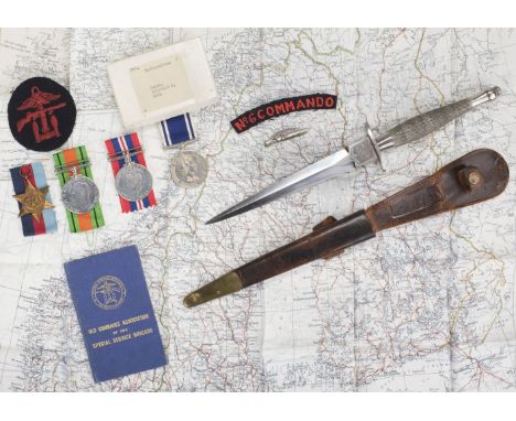
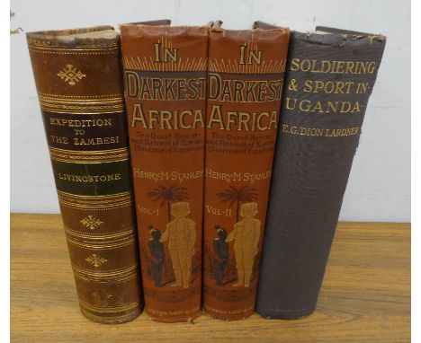
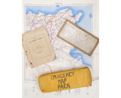
* Fighting Knife. A WWII collection belonging to Corporal R.G. Wall, No 6 Commando, including a 1st Pattern Fairbairn Sykes Fighting Knife by Wilkinson Sword & Co Ltd, London, a fine original example with 17.5 cm double edge blade etched with trademarks on either side of the ricasso, "S" guard, chequered grip and top nut, overall length 30 cm, in its brown leather scabbard with brass chape, WWII service medals comprising 1939-45 Star, War and Defence Medals, Police Long Service Medal, E.II.R. (Const. Reginald. G. Wall) extremely fine, the latter in named card box of issue, several original WWII Commando documents including Commando Service Certificate dated 28 September 1945, Holding Operational Commando Pass dated 2 August 1945, another dated 23 August 1945, Old Comrades Association of the Special Service Brigade blue book dated 19 August 1943, No 6 Commando cloth shoulder title, Combined Operations Command cloth badge, silk escape map of Scandinavia and the Baltic 1:3,000,000, another double-sided of France and Germany 1:2,350,000, "war souvenirs" including a German Army belt, the leather faintly scratched with the initial R.G.W. (presumably Corporal Wall laying claim), Norwegian M1894 bayonet in its scabbard numbered 286, veterans Commando badges and other itemsQTY: (1)NOTE:See lot 193 (WWI medals awarded to Wall's father). A letter is sold with the lot which gives vague details of the previous owners father's service in Norway to carry out attacks. It is therefore surmised that Wall took part in Operation Archery.On 27 December 1941, No 6 Commando took part in Operation Archery, also known as the Måløy Raid. It was a British Combined Operation raid against the Germans on the island of Vågsøy, Norway.The objective was the destruction of fish-oil production and stores which the Germans used in the manufacture of high explosives. Another intention was to cause the Germans to maintain and increase forces in Norway, which would reduce forces deployed on the Eastern Front, thereby giving a numerical advantage to Allied forces.Four fish oil factories and stores were destroyed and German prisoners were taken with a loss of 17 Allied killed and 53 wounded.
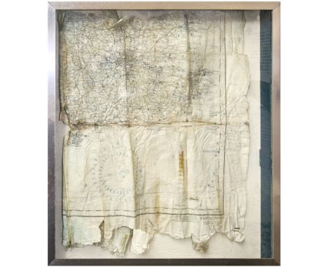
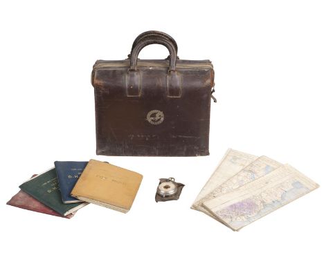
Lot 235

* Aviation Maps and Manuals. WWII period aviation collection belonging to Richard Charles William Ellison, RAF, including aviation maps, Midlands and Wales RAF Edition War (2), North Scotland RAF Edition War, Sheet 1 G. Britain The Border 1934, Sheet 2 Scotland S. West 1934, Sheet 3 Scotland The Firth and Tay 1934, Sheet 4 Scotland Glasgow, Oban & Southern Isles 1934, Sheet 5 England Midlands (N) 1937, Sheet 5 England Midlands (N) 1937, Sheet 8 England Midlands (S) 1937, 1 x Sheet 11 England South) 1937, manual instructions for DH 60 Gypsy Moth, DH 89 Dragon, DH 85 Leopard Moth, DH 83 Fox Moth, DH Gypsy Major, DH Gypsy Six, DH Gypsy 11, Dunlop Low-Pressure Aeroplane Tyres and Wheels, Flight Operation Computer 1st August 1943, a Consolidated Vultee Flight Bag contents comprising Map marked with mission routes, Flight Manual No. 1354 B24D dated Sept 15 1942, Flight Manual No. 3528 B24D + J dated January 1944, Service and Training Manual Hydraulics B24D (inscribed R.C.W Ellison No. 5960 August 1942), Service & Instruction Manual Armament B24D No. 5917 dated October 1, 1942, Service & Instruction Manual Airplane General B24D No. 1552 dated October 1, 1942, Computer Dead Reckoning Mk. 4A 6B/2645 in canvas case, Azimuth Sight Instrument in Leather case and other items relating to his service QTY: (1)NOTE:Richard Charles William Ellison was born in 1908, he served with the RAF and was transferred to the reserve list in 1933 and he was a flight instructor at Hamble, Hampshire in 1935 and also it is noted on his service record that he was also a flight instructor in Ayr.

Lot 303

* Pratt & Whitney. A modern model of a Pratt & Whitney Aircraft radial engine, with articulated chrome two blade propeller, mounted on a wooden base with Pratt & Whitney enamel plaque, 29 cm high, together with a miscellaneous collection of aviation items including two ashtrays showing a Lockheed over a map of Australia each dated 1946, 17 cm wide and other itemsQTY: (8)

Lot 356

* Luftwaffe. A WWII night navigational map for the United Kingdom and the opposite side for Northern Europe, yellow waxed cloth, 1: 2,000,000 scale and dated 1941, pinprick holes over Southampton, Kingston and Chesterfield as well as other locations, 55 x 70 cmQTY: (1)

Lot 40

* Escape & Evasion. A WWII silk escape map, Scandinavia and the Baltic, 1: 3,000,000 dated 1 April 1940, two tissue paper maps for Eritrea and Northern Europe, plus four 1950s silk maps, flechettes, German padding dated 1939 and various badges QTY: (1)

Lot 548

* Hurricane P3049. Relics recovered from Hurricane P3049 which was shot down on 7 September 1940, including inert rounds and a message note, presented in a glazed frame with information, frame size 46 x 46.5 cm, plus a section of an airman's map also recovered from P3049 (this loose)QTY: (2)NOTE:Important Notice: All lots from the Tonbridge Battle of Britain Museum (lots 401-557) will remain in situ in the Museum and will only be available for viewing and collection from there in Tonbridge, Kent. All viewings and collections are strictly by timed appointment - please see front of catalogue or contact the auction office for details.Provenance: Tonbridge Battle of Britain Museum, Malcolm Pettit.Hurricane P3049 was shot down in combat over the Thames Estuary on 7 September 1940. The aircraft crashed at Elmley, Spitend Point, Sheppe. The pilot, Flight Lieutenant Hugh Richard Aden Beresford of 257 Squadron was reported 'missing'.The aircraft was excavated in 1979 and revealed that his remains were still in the cockpit. Beresford was buried at Brookwood Military Cemetery on 16 November 1979.

Lot 2126

R.W. Seale: an unframed antique hand coloured map print of Asia Minor by M.R. Toms

Lot 2118

An unframed mounted antique hand coloured map print of Derbyshire by Saxton and Hole (circa 1637) - 28.5cm X 31.5cm

Lot 2108

An unframed mounted antique hand coloured map of Rutlandshire - sold with a framed monochrome map print of Hertfordshire

Lot 200

James Bond ; A large and heavy quality 1:8 scale Eaglemoss diecast precision model of James Bond's Aston Martin DB5. Highly detailed, the original spec for the model includes; working rear and front lights, working horn, ejector seat, accelerator sound effects, brake lights, light up map to interior, machine guns in lights, movable bullet proof rear screen, key ignition, rubber tyres etc. This particular model is well made. .

Lot 1

A LARGE ROLLABLE WALL MAP BY W. LEIRING 1961 SHOWING EUROPE BEFORE WW1, APPROX 196 X 150 CM

Lot 4

A LARGE ROLLABLE WALL MAP BY GEORGE WESTERMANN SHOWING THE MIDDLE EAST AND INDIA - APPROX 194 X 154 CM

Lot 5

A LARGE ROLLABLE WALL MAP BY GEORGE WESTERMANN SHOWING EUROPE IN THE TIME OF THE 15TH CENTURY - APPROX 206 X 131 CM

Lot 2

A LARGE ROLLABLE WALL MAP BY GEORGE WESTERMANN SHOWING THE TERRITORIES OF GERMANY BETWEEN 1789 - 1815 , APPROX 212 X 135 CM

Lot 3

A LARGE ROLLABLE WALL MAP BY GEORGE WESTERMANN SHOWING EUROPE IN THE TIME OF OTTONES AND SALIANS APPROX 205 X 135 CM

Lot 6

A LARGE ROLLABLE WALL MAP BY VELHAGEN & KLASING 1961 SHOWING THE SOVIET UNION AT THE TIME - 193 X 134 CM

Lot 2111

James and Christopher Greenwood: a set of four original hand coloured map prints, comprising Suffolk 1831, Lancashire 1830, Oxfordshire 1832 and Dorset 1829 - each 60cm X 70cm

Lot 2120

An unframed mounted antique hand coloured map print of Devonshire - sold with a hand lined map of Durham by Creighton & Walton

Lot 2062

Richard Blome: a gilt framed antique hand coloured map print of 'Barkshire'

Lot 2109

A framed late state hand coloured map print of Paris in 1578 with decorative and figural border

Lot 2078

Robert Morden: a gilt framed antique hand coloured map print of Northamptonshire - slipped in frame

Lot 259

A modern globe pattern drinks cabinet with printed map decoration and shaped undertier, set on casters

Lot 2070

J. & C. Walker: a gilt framed antique partially hand coloured map print of Cornwall - sold with two monochrome Penzance engravings

Lot 2029

A gilt framed antique hand coloured route map print from Exeter to Dartmouth with text to margin and under image (Plate 169)

Lot 154

A WUCAI INSCRIBED TEA-CADDY17th centuryThe vessel with cylindrical body bulging slightly at the side painted in underglaze blue and polychrome enamels with a cricket hopping amidst grass and aster flowers, the upper register with calligraphic inscription in zhuanshu script focusing on the joy of living in seclusion, with a later reed cover, shifuku, Japanese wood box. 9cm (3 1/2in) high. (3).Footnotes:十七世紀 青花釉里紅花蟲圖詩文小茶罐The inscription reads:雲飛嚴接翠連天,結個茅蓭不費錢。流水直通茶灶下,梅花開向臥床前。Which may be translated as:Drifting clouds join with the emerald sky, to weave a thatched hut costs nothing.Flowing water runs beneath the tea stove, the plum blossoms bloom before the bed.The present lot may have been made for the Japanese market, as the shape is similar to other Japanese chaire or tea-caddies; see for example, a Japanese pottery tea-caddy, 17th century, in the Metropolitan Museum of Art, New York, (acc.no.29.100.664).Although trade between China and Japan by vessels of either nation was officially banned by Ming emperors during the 16th century, following the weakening of central authority and power, Chinese merchants regularly sailed from Nanjing, Fuzhou, Quanzhou and Xiamen to Nagasaki; see for example the early 17th century 'Selden' map of China and East Asia, in the Bodleian Library, Oxford, which shows the 'unofficial' lined trade routes between China and Japan (acc.no. MS.Selden supra 105). From the end of the Wanli reign until the overthrow of the Ming dynasty in 1644, Chinese merchants exported wares for use in the Japanese tea ceremony. These pieces became known to the Japanese as 'Ko-sometsuke' (literally 'old blue and white'). The feudal lords and their tea masters who ordered these wares required original designs for their personal use or limited number of followers. Although orders were small, the prices paid were very high.Compare with a similar wucai tea-caddy, 18th century, which was sold at Sotheby's New York, 16 September 2017, lot 839.For further information on this lot please visit Bonhams.com

Lot 3035

Chris Reynalds Ltd Edition print of fireman framed Wills Cigarettes cards and 1774 framed map of Faversham

Lot 1003

WILSON'S MODERN POCKET TRAVELLING MAP OF THE ROADS OF IRELAND engraved by Baker, framed. Visible sheet 43cm by 33cm

Lot 942

Eustace, Rev J. C. - 'Italy', from the original map by G. A. Rizzi - Zannoni, engraved for 'The Classical Tour through Italy, dissected map, linen back in original sleeve, published 1814, 105cm x 44cm.

Loading...Loading...
  • 109198 item(s)
    /page

Recently Viewed Lots