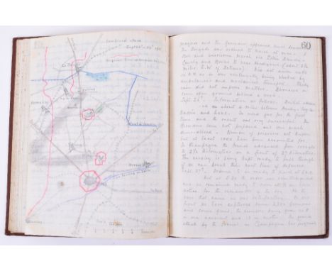

Outstanding Great War and Irish Troubles Handwritten Diary Covering the Period 1914-1921 Compiled by the Commanding Officer of the 11th Hussars, Lieutenant Colonel R.J.P.Anderson C.M.G., D.S.O. As a professional soldier, educated at Winchester, with considerable experience of earlier campaigns, including the North-West Frontier and Boer War he brings a perceptive and seasoned eye and broader perspective to the actions he describes. As well as the Great War there is considerable Irish interest covering a difficult period in 1920 & 1921. The diary is clearly written in two Correspondence books (Field Service) and entries are therefore full of detail and very readable. The diary starts with a general hand drawn map of the units movements following its retirement from Mons and a telling list of those Officers who embarked, all but six of whom were killed or wounded. By August 18th the Hussars are deployed and significant action and casualties are daily occurrences. This a source reference of considerable importance, and confusion, friendly fire as well successes against the Germans are all described with units, places and dates and times confidently written. The attrition of experienced Officers and men during the First Ypres battle comes across very clearly. Wounded by a shell, along with 3 others he is evacuated to England. He returns to the front in March 1915, one of his first tasks is to visit the well preserved grave of a fellow Officer with whom he was obviously close. He is called on to bolster the French following the surprise Gas attack and he describes the difficult fighting that resulted and his lucky escape from shell fire. The hand drawn coloured maps, many showing trench lines are exceptional well executed. On the Somme he is called upon to provide a cavalry force ready to exploit the breakthrough expected but not achieved "back in billets a very depressed lot" He details the moves and plans for further exploitation, which again come to nothing. "It really looks as though there was no future for us except as infantry" He also provides a very detailed account of similar experiences waiting for an opportunity to use cavalry during the Arras operations and the withdrawal to the Hindenburg line in 1917, together with much on the problems the cavalry were facing in terms of forage, suitable stabling, low quality replacements and the appalling weather. Also much perceptive description and comment on the poor state of the French army after the lack of success of their Spring Offensive. Interesting experience during the Cambrai battle where a planned attack is cancelled at the last moment and has to use his men in a dismounted role. During the confusion of the German March Offensive he takes command of all troops in the 72nd Brigade holding off a German attack and doing considerable execution, forced to withdraw his troops suffer heavy casualties and loose most of their horses. He describes a bayonet charge and hand to hand fighting. Includes a copy of Douglas Haig's famous "Backs to the Wall" order tipped-in. He takes part in the famous Amiens battle in a mounted role and the change of mood is very clear from his writing. On news of the Armistice he writes "it seems to good too be true". Part of the Occupation force in Germany he returns in February 1919 to England. As a regular Officer his service continues in Egypt (where his wife manages to visit) and later in Ireland (1920), with both interesting commentary on the troubles and description of ambushes and "murders". ie Dec 12th 1920 "At Cork last night at 7.30 a bomb was thrown into a lorry load of Auxiliary Cadets, killing one and wounding the remainder. In a few hours half of Patrick Street was in a blaze.." etc. etc., Overall an exceptional contemporary account, well written and providing valuable insights. A highly important source reference (two volumes with two loose maps charting Anderson's movements in 1914)
We found 109182 price guide item(s) matching your search
There are 109182 lots that match your search criteria. Subscribe now to get instant access to the full price guide service.
Click here to subscribe- List
- Grid
-
109182 item(s)/page

Mixed and Interesting Grouping of Third Reich and Related Ephemera, includes song books, Reibert Schutzenkompanie, rare Frontkalender for 1943, map, Catholic "Feldgefanbuch" reproduction Soldbuchs and interesting late 1920's photograph album of life in a German city, captioned imges etc. c 16 items in all.

Royal Air Force Observer's and Air Gunner's Flying Log Book of 1066980 F/Lt J Ormerod. June 1942 – Jan 1945. Includes loose photo postcard dated 1941. Flew in – Proctor, Blenheim, Wellington, Hudson, Loadstar, Oxford, Harvard. Flew with 162 Sqn MEF, 40 Sqn – full dated list of units at rear. Some early log pages updated with pasted over pages. Flight duties as Front/Rear gunner/Wireless Op. Operational entries include flights over Western Desert prior to El Alamein ‘El Alamein Battle Area - Tank jamming & bombing’ and 23/10/42 ‘El Alamein Battle Area - Tank jamming at commencement of offensive. Artillery barrage terrific.’; ops over Halfaya Pass, Gazala Road, Tunis Harbour. Jan 1943 ‘Fairly accurate flak’ over Sousse Harbour. 1943 ops over Tunisia – Gabes, Sfax, El Gardabia, 24/04/43 ‘Attacked by night fighter for 5 mins... did not get holed.’ Operational flights enumerated, total 39 between Aug 1942 and May 1943, later became an Instructor in South Africa. Hand drawn map of Med with places stationed & bombed highlighted.


Cilicia, Mallos AR Stater. Circa 440-400 BC. Bearded male deity with two pairs of wings in kneeling-running stance to left, holding solar disc with both hands / Swan standing to left, eagle upon its back; MAP before, all within incuse circle. BMC -; SNG von Aulock -; SNG Copenhagen -; SNG France -, cf. 375-6 (same obverse die?); SNG Levante -; cf. Traité 1394, pl. CXXXVII, 20 (swan to right); Casabonne -; MIMAA -.11.08g, 20mm, 10h. Near Extremely Fine. Apparently unique and unpublished. From a private North American collection.

Cilicia, Mallos AR Stater. Circa 440-400 BC. Bearded male deity with two pairs of wings in kneeling-running stance to left, holding solar disc with both hands / Swan standing to right, eagle upon its back; MAP?O before, all within incuse circle. BMC -; SNG von Aulock -; SNG Copenhagen -; SNG France -, cf. 375-6 (same obverse die?); SNG Levante -; Traité 1394, pl. CXXXVII, 20; Casabonne -; MIMAA -. 11.18g, 20mm, 3h. Extremely Fine. Apparently the second known example. From a private North American collection. Mallos (archaically known as Marlotas) issued a rich coinage between the early fifth century and 333 BC, when it came under Macedonian hegemony, featuring Greek deities including Herakles, Aphrodite, Athena, Hermes, Dionysos and Demeter, as well as securely identifiable oriental deities such as Baal and Ahuramazda. The solar deity present on the obverse of this coin is sometimes identified as Kronos (a Semitic god more properly known as 'El', and distinct from the Greek Titan and father of the Olympian gods, but with whom he was syncretised by Greeks). This seems eminently logical, since the spiral attribute, used on later issues - which Robert Graves called a 'spiral of immortality' (The White Goddess, 1948), a symbol of power most likely appropriated from the Red Crown of Lower Egypt - and solar disc attributes do not belong to any Olympian deity, but to one of near-Eastern origin. It has moreover been suggested that Mallos was originally of Phoenician foundation (see IACP, 1009) on the basis of its original ethnik, a suggestion supported by the presence of other Semitic deities portrayed on the city's coinage, as well as the use of Aramaic legends. Curiously, the attribute of the solar disc is one with few parallels in the archaeological record. In a similar pose, a male solar deity is carrying a sun disc on a 6th century orientalising archaic Greek scarab from Cyprus, and an alabastron from the Isis tomb at Vulci, Etruria (suggested locations for its manufacture are Cyprus and Phoenicia) depicts a female carrying a winged sun disc. Possibly related also are Phoenician terracotta figurines from Punic sites holding a disc in front of them. In all cases a Semitic origin is apparent, further strengthening the likelihood that the deity of this coin should be the Semitic solar god 'El'.

Cilicia, Mallos AR Stater. Circa 440-400 BC. Bearded and winged male deity in kneeling-running stance to right, holding solar disc with both hands / Swan standing to left, eagle upon its back; MAP above, ankh symbol before, all within incuse square. BMC -; SNG von Aulock -; SNG Copenhagen -; SNG France -; SNG Levante -; Traité -; Casabonne -; MIMAA -. 11.01g, 20mm, 9h. Near Extremely Fine. Apparently unique and unpublished. From the collection of P.R., United Kingdom.


John Speed (17th century) - Map of Suffolk, 39.5 x 50cm approx, Christopher Saxton and John Speed, 17th century Map of Worcestershire, 39.5 x 52cm approx, a further 17th century map of Suffolk, 53 x 63cm approx, all framed, together with Fairburn's Map of the Country, 12 miles around London, 1800, 56 x 54cm approx, unframed

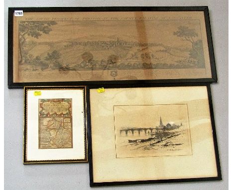
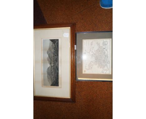
Sir David Young Cameron, RA, RSA (British 1865-1945) - Perth Bridge, monochrome etching, unsigned, 19 x 27cm, an 18th century map of Cambridgeshire, entitled - The Road from London to Kings Lyn (sic), 18 x 12cm, Samuel and Nathaniel Buck - The South Prospect of Preston in the County Palatine of Lancaster, 29 x 75cm, further 19th century and other topographical engravings, WJ Maskell (20th century British school) - Three Views of Cambridge, unframed, etc


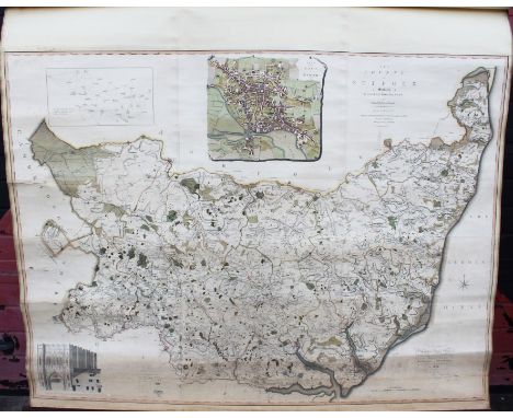
Hodskinson's large scale map of Suffolk by William Faden, hand-coloured, 1783. "The County of Suffolk Surveyed by Joseph Hodskinson, of Arundel Street, Strand, London. Engraved and Published by William Faden, Geographer to The King (Surveyor to Mr Jefferys), Charing Cross. Aug 14. 1783". Together with the titled wooden case and roller, 4ft x 5ft

Early Victorian hand-coloured map - "Map of the Parish of Saint Matthew in the Borough of Ipswich and County of Suffolk 1846. This map is a true and correct copy of the First Class Map made for the Commutation of the Tithes, and examined and tested by the Tithe Comm:rs with the edition of that part of the Town of Ipswich lying in the Parish of Saint Matthew. William Browne & Co. Surveyors Norwich". Only three copies of this map were ever produced, one is in the National Archives. Together with part of the original metal tube case, 206cm x 130cm


Rare 16th century Geneva 'Breeches' Bible: Imprinted at London by Christopher Barker dwelling in Pater nofter Rowe at the figne of the Tygres Head, 1577, Genesis Chapter III, verse 7, which reads: 'Then the eyes of them both were opened and they knew they were naked and they fewed figge tree leaves together and made them felves 'breeches', later leather binding, 27cm x 19cm CONDITION REPORT Including title page- preliminary pages at Genesis one- 6 pages, map midway through. New testament has 115 leaves followed by 11 leaves of tables. Metric Psalms included. Bound together with The Whole Booke of Psalmes imprinted at London by John Day 1576. Rebound, contents appear to be complete but with minor losses to edges- p274 with large loss. Generally some staining, a few repairs, binding with splits at spine

Rare George II hand-scribed and polychrome painted Estate map on vellum - 'An exact Survey of lands called Layham and Fenns lying in the Parish of Little Bromley in the County of Essex belonging to Capt. Kilbarn Gent. Containing 32.1.57 (acres, rods, perches) Jo. Kendall, 1732', rolled, 53cm x 62cm approximately .

Rare early 18th century hand-scribed and polychrome painted Estate map on vellum depicting 'Bieleigh (sic) Abbey and Grange in the Parish of St. Peters, Maldon, Essex......John Bludworth Esq......by William Brazier', variously inscribed, with titled cartouche, compass and key, rolled, approximately 60cm x 49cm


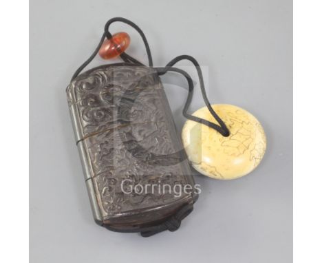
A Japanese carved wood inro with an ivory manju netsuke, 19th century, the inro carved in relief with a dragon amid clouds, 7.2cm, restorations, the manju engraved with a map of Japan's Provinces, with delicately engraved names, signed Nanka, Izumi Province, first half 19th century, 3.5cmProvenance: purchased from Christie's for £104.50 in November 1977.


-
109182 item(s)/page