We found 109182 price guide item(s) matching your search
There are 109182 lots that match your search criteria. Subscribe now to get instant access to the full price guide service.
Click here to subscribe- List
- Grid
-
109182 item(s)/page


Lot 33
Walters (Stephen), (Intro), The Voyage of the Bounty Launch, John Fryer's Narrative, signed, no.92 of ltd edn of 500, fldg map, hf mor gt, 4to, slip case, 1979; Bligh (William), Bligh's Narrative of the Mutiny Aboard HM Ship Bounty, no.396 of 1000, 2nd vol of Australiana Facsimiles and other volumes on the Mutiny on the Bounty and Pitcairn Island.


Lot 57
Wyld (James), Wyld's Road Director through England and Wales, hand-coloured outlines, sectionalised in fifteen sections, laid on linen, 1858, 63 x 58cm, in slip case; and Wyld's Map of England, Wales and Scotland, hand-coloured outlines, sectionalised in twenty-four sections, laid on linen, nd, 78 x 66cm, slip case, (2).


Lot 82
Van Keulen, GH, A New Gradually Encreasing Compass Map of a Part of the Sea Coasts of England, in which is contained the Coasts of Devonshire extending from Bridport to Big Berry with their shallownesses and depths, by Nicholas de Vries, Amsterdam, 1780, uncoloured, 63 x 54.5cm and Anon, A New and Correct Chart of the Channel, no date, Plates 6 & 7, uncoloured, showing Cornwall, Devon, Dorset, Hampshire, Sussex and Kent and the northern coast of France, 61.4 x 54.2cm/62.5 x 54.2cm, (3).


Lot 16
Adam Johann von Krusenstern (1770-1846), Voyage Round the World in the Years 1803, 1804, 1805, & 1806, by order of His Imperial Majesty Alexander the First, on board the Ships Nadeshda and Neva, Volume 1, London: Printed by C. Roworth and T. Davison for John Murray and the Board of Longitude, 1813, with hand-coloured aquatint frontispiece and folding engraved map, in original half leather binding with marbled paper


Lot 1
London Passenger Transport Board 'SECOND ANNUAL REPORT AND ACCOUNTS for the year ended 30 June 1935. 65pp booklet including several pages of photographs and the 4 fold-out, detachable MAPS of the Underground, Buses, Green Line Coaches and Trams & Trolleybuses which were unique to these reports. Plus a similar, loose Underground map from another year. In good condition, maps are very good. [1 booklet w/maps + 1 extra loose map]

Lot 100
1919 London Underground MAP OF THE ELECTRIC RAILWAYS OF LONDON 'What to See & How to See it' with print-code 395-500M-2-10-19. Has the red bullseye on the cover and opens out in 8 panels to 13.7" x 10.9" (34 x 28cm). An excellent copy, a trace of adhesive at the spine and the usual age-darkening of the paper but still crisp and firm. [1]


Lot 112
c1910 Evening News LONDON TUBE MAP & GUIDE. Produced by George Philip & Sons and features a unique cover design of tunnel segments, one for each tube line (the sub-surface Underground lines are given equal status on the map!). Folds out from card covers to 23.5" x 19.5" (60cm x 50cm) and has a tramways map on the reverse. Light wear to the covers, the map is in excellent condition. [1]
Lot 121
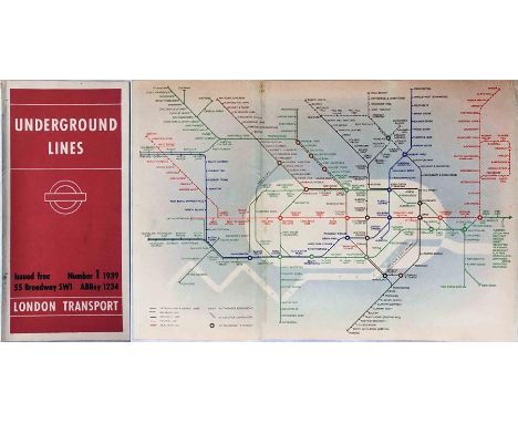
1939 London Underground diagrammatic, card POCKET MAP designed by Hans Schleger (aka 'Zero') who produced a short series from 1938-41 before responsibility was handed back to Beck. This is issue No 1, 1939 and is good condition with a trace of adhesive/stain on the spine where it was once tipped into a guidebook. [1]


-
109182 item(s)/page