We found 108737 price guide item(s) matching your search
There are 108737 lots that match your search criteria. Subscribe now to get instant access to the full price guide service.
Click here to subscribe- List
- Grid
-
108737 item(s)/page


![[Bleau] Denbigiensis Comitatus et Comitatus Flintensis; Denbigh et Flintshire, no date, hand-coloured engraved map, French te](https://cdn.globalauctionplatform.com/21519436-5913-4933-a642-aea2010b9a73/9b427c88-47ff-438e-8389-aef600f84d21/468x382.jpg)
Lot 1063
[Bleau] Denbigiensis Comitatus et Comitatus Flintensis; Denbigh et Flintshire, no date, hand-coloured engraved map, French text verso, framed, glazed front and rear;[Saxton] & Hole, Englalond Anglia Anglosaxonum Heptarchia, no date, engraved map, uncoloured, mounted framed and glazed;Ogilby (John), The Roads from Shrewsbury and Chester to Holywel com Flint, hand coloured road map, no date, mounted framed and glazed;[Morden], Comitatus Rotelandiae Tabula Nova, no date, hand-coloured engraved map, mounted framed and glazed;with seven small format maps of Buckinghamshire, Shropshire, Cumberland, Westmoreland, Chester, the road from Exeter to Barnstable and the road from London to Aylesbury. (11)


Lot 332
MAP OF THE COAST OF ARABIAthe title cartouche with the following details: 'the red sea & Persian Gulf drawn from the chart of the Eastern Ocean, publish'd in 1740, by order of ye Count de Maurepas, improv'd from particular surveys and regulated by Astronomical Observations', the reverse with letter of Authenticity from the Arabesque Gallery & Interiors stating that the map dates from 1747, 22cm x 35cm


Lot 248
KING DANIEL (Pub). The Vale-Royall of England or The County Palatine of Chester. Eng. title & fldg. & other eng. plates (repaired &/or relaid). Recased old embossed leather. 1656; also 2 other vols. (3).King - Missing plate of Chester and map of Isle of Man. Only 9 plates of Arms (of 11). Various repairs etc as catalogued.


Lot 151
SMITH C. A New Map of England & Wales Comprehending the Whole of the Turnpike Roads with the Great Rivers & Railways. Fldg. hand col. eng. map. Orig. cloth slip case. 1838; also Edward Stanford Ltd., The Oarsman's & Angler's Map of the River Thames, New Edition, fldg. col. map in orig. cloth. (2).


Lot 211
BRUCE A. B. The Life of William Denny, Ship-Builder, Dumbarton. Port. frontis & fldg. map. Worn orig. blue cloth, internal foxing. Pres. copy from Denny's mother, 1888; also Fairbairn, Useful Information for Engineers, plates & illus., orig. cloth, 1860 & various others, transport & engineering interest.


Lot 39
LEJEUNE BARON, Aide-De-Camp to Marshals Berthier, Davout & Oudinot. Memoirs. 2 vols. Rubbed dark half calf, rather poor internally. 1897; also H. N. Coleridge, Six Months in the West Indies, fldg. eng. map, 16mo, half calf, 1832 & Bruce's Travels in Abyssinia & Nubia, dark prize calf, 1873. (4).


Lot 309
Various Kent related Hasted maps to include, 18th century map of the hundred of Eyhorne Kent, 49 x 38cm another of the hundreds of Great Barnfield and Selbrittend and another of the hundreds of Cranbrooke Barkley and Rolvenden (3)Generally in a good condition with no major signs of damage or repair. All show signs of wear and discolouration that is commensurate with age.Map of Eyhorne- Some small nicks on the paper surface and some creases.Selbrittenden- small area of damage between the E & D of 'Hundred' in the lower right quadrantCranbrooke- most noticeable discolouration out of all three
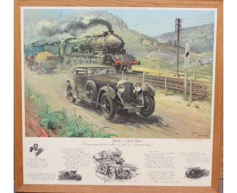
Lot 2015
A framed 'Bentley V Blue Train', Terenco Cuneo, print, 'From the Original Oil Painting'. With Printed Text across the bottom, frame measuring approx. 32" x 34"; together with a framed Great Western Railway map; a framed print of Dainton Conquered, Alan Fearnley; two framed sets of Wills' cigarette railwayana cards; David Shepherd The East Somerset Railway print and others. (Q)
Lot 12
NO RESERVE China.- Ellis (Henry) Journal of the Proceedings of the late Embassy to China..., first edition, portrait frontispiece, 7 hand-coloured aquatints, 2 engraved maps only (of 3, lacking folding map), some light marginal finger soiling, cracking to gutter in several places, some pages and a couple of plates loose or working loose, dis-bound, some bumping to corners, 4to, 1817.
Lot 14
NO RESERVE Europe.- Brydone (Patrick) A Tour through Sicily and Malta. In a series of Letters to William Beckford, 2 vol., second edition, engraved folding map, occasional scattered spotting, slight browning, contemporary calf, lightly rubbed, joints splitting but covers holding firm, 1775 § Davies (Rev J. Sanger) Dolomite Strongholds. The Last Untrodden Alpine Peaks, second edition, map and 9 plates, finger-soiling to half-title, cloth gilt, lightly rubbed, 1896 § Conway (Sir W. M.) The Alps from End to End, 16 plates, very occasional splitting at gutter, the odd spot, endpapers slightly browned with scattered spotting, covers rubbed, spine ends chipped with small loss to foot, t.e.g., others uncut, 1905, half-titles, all but first original cloth with spines sunned; with others travel and sport, v.s. (9)
![Herodotus. Historion logoi [graece]...Historiarum libri IX, Greek & Latin text in parallel columns, folding engraved map](https://cdn.globalauctionplatform.com/000945ca-6f1d-4be5-a1b9-aee700ed4404/2ac0e04e-299b-4ccc-a3a4-aee700f912d6/468x382.jpg)
Lot 162
Herodotus. Historion logoi [graece]...Historiarum libri IX, Greek & Latin text in parallel columns, folding engraved map (a couple of tears, repaired), worming to first half of volume (mostly single hole but worse at beginning and affecting map), lower corner of 3O4 torn away not affecting text, later half calf, worn, joints split with upper cover almost detached, lacking corners, [Wing H1584], E.Horton & J.Grover, for J.Dunmore [& others], 1679 § Plinius Secundus (Gaius) Naturalis Historiae, 3 vol., engraved additional titles, letterpress titles with woodcut printer's device, contemporary ink signature of Geo. Nicols, vol.3 broken with some leaves becoming loose, contemporary calf, rather worn, spine of vol.3 defective, Leiden & Rotterdam, Hackius, 1669-68; and another, folio & 8vo (5)
![Holy Land.- End of the British Mandate for Palestine.- Macmillan (Lt.-Gen. Gordon H. A.) Palestine [2nd Phase], lithographed](https://cdn.globalauctionplatform.com/000945ca-6f1d-4be5-a1b9-aee700ed4404/33ce46c2-f62d-43c6-b1fa-aee700f9a457/468x382.jpg)
Lot 17
Holy Land.- End of the British Mandate for Palestine.- Macmillan (Lt.-Gen. Gordon H. A.) Palestine [2nd Phase], lithographed map printed in red and black ink, with date added in manuscript pen and ink, 300 x 260 mm (11 3/4 x 10 1/4 in), exposure lines and toning, ring-binder holes present in lower right margin, surface dirt, unframed, 17th May 1948⁂ In February 1947 Macmillan was appointed GOC British Forces in Palestine and Trans-Jordan. Soon after his arrival, the British Government decided to bring to an end its Mandate in Palestine. This decision triggered an escalation of violence in the territory, leading to the withdrawal of all British forces by 30 June 1948.

Lot 184
Defoe (Daniel) The Life and Strange Surprising Adventures of Robinson Crusoe, 2 vol., seventeenth edition, engraved frontispiece, folding map, and plates, light foxing or offsetting, bookplates to pastedown, contemporary ink ownership name to front free endpaper, contemporary calf, rebacked, endpapers renewed, an attractive set, 1791; and 6 others, antiquarian, including a Restoration play from 1673, v.s. (7)

Lot 20
India.- Coronation Durbar at Delhi (The), ink gift inscription "given to Lady Llangattock who was present at the Durbar" to half title, Baroness llangattock's bookplate to pastedown, map of Delhi to rear, very light foxing to first few pp., contemporary half morocco, spine gilt in compartments, g.e., one or two bumps to extremities but overall a near-fine copy, 8vo, Allahabad, Pioneer Press, 1903.⁂ The Delhi Durbar of 1903 was conceived by Lord Curzon to celebrate the succession of Edward VII and Alexandra of Denmark as Emperor and Empress of India. On 24 January 1901, two days after the death of Queen Victoria, King Edward VII was proclaimed the Emperor of India. King Edward, for many ruling heads of the states in the Indian subcontinent, was remembered as the 'Prince of Wales' after his prolonged tour of the country in 1875-1876. The book is made up of telegrams which appeared in "The Pioneer". Provenance: Georgina, a Rolls, Baroness Lady Llangattock (1837-1923) was a socialite and supporter of Horatio Nelson and wife of John Rolls, 1st baron Llangattock, mother of Charles Stewart Rolls of Rolls-Royce motoring fame.
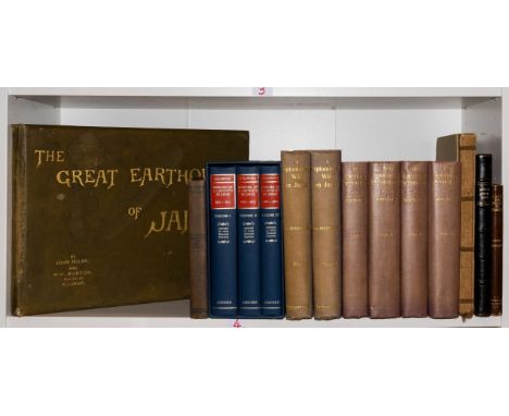
Lot 23
Japan.- Milne (John) and W. K. Burton, The Great Earthquake in Japan, 1891, second information, 30 photographic plates by Kazumasa Ogawa, with captioned tissue guards, map, occasional light damp-staining, some slight splitting at gutter, original cloth, spine sunned, covers slightly soiled, extremities rubbed, Yokohama, [1894] § Ledoux (Louis V.) A Descriptive Catalogue of an exhibition of Japanese Figure Prints, colour frontispiece, plates, endpapers browned, calf-backed boards, extremities a little scuffed, uncut, New York, The Grolier Club, 1924 § Fraser (Mrs. Hugh) A Diplomatist's Wife in Japan, 2 vol., second edition, plates and illustrations, bookplates, some spotting or foxing, endpapers browned, original pictorial cloth, gilt, spines sunned, ends bumped, 1899; and 12 others, Japan and Asia, v.s. (16)⁂ The first, a superb photographic record of the devastating earthquake in Japan.

Lot 243
NO RESERVE Klibansky (Raymond), Erwin Panofsky and Fritz Saxl. Saturn and Melancholy, plates, original cloth, dust-jacket, lightly toned, chips and small tears to extremities, 1964 § Asbridge (Thomas S.) and Susan B. Edgington. Walter the Chancellor's The Antiochene Wars, map, original cloth, 1999, 8vo (2)
Lot 32
NO RESERVE Southeast Asia.- Wheatcroft (Rachel) Siam and Cambodia in Pen and Pastel, plates, folding map at end, bookplate of C. E. Rusbridge, some light spotting, occasional splitting at gutter, endpapers browned, original cloth, quite rubbed, spine slightly sunned, shelf-lean, 1928 § Houghton (Rev A. T.) Dense Jungle Green. The First Twelve Years of the B.C.M.S Burma Mission, photographic plates, contemporary ink ownership inscription to half-title, spine creased with a few chips to head, 1937 § Aung (Maung Htin) Burmese Drama. A Study, with Translations, of Burmese Plays, ink stamp of the People's Literature House Rangoon to front free endpaper, 1956, all but first with original wrappers, lightly rubbed with a few patches of soiling; and others Thailand, Myanmar and Cambodia related, v.s. (c.55)
![Tonga.- [Vason (George)] An Authentic Narrative of Four Years' Residence at Tongataboo, engraved frontispiece, previous owner](https://cdn.globalauctionplatform.com/000945ca-6f1d-4be5-a1b9-aee700ed4404/171ca7ee-a39e-4fb3-8a46-aee700f90a36/468x382.jpg)
Lot 34
Tonga.- [Vason (George)] An Authentic Narrative of Four Years' Residence at Tongataboo, engraved frontispiece, previous owner's ink signature and notes to title, engraved map, trimmed at edges, lacking 2F1, scattered spotting and staining, ex-library with occasional ink-stamps, later half-morocco, rubbed and worn, 1810; and 2 others on the life of Vason, 8vo (3)

Lot 4
NO RESERVE Africa.- Morgan (John) Reminiscences of the Founding of a Christian Mission on The Gambia, very occasional spotting, original cloth, spine gilt but sunned, lightly rubbed, Wesleyan Mission House, 1864 § Dun (Major T. I.) From Cairo to Siwa: Across the Libyan Desert with Armoured Cars, second edition, illustrations, some photographic, 1 mounted plate printed in silver and another in gold, folding map (creased) and coloured plan of Cairo, text printed in red and black, some scattered spotting, original cloth-backed boards, rubbed, upper cover lightly soiled, Cairo, [c.1933]; and others, 19th century Africa, v.s. (5)
Lot 40
Kent.- Harris (John) The History of Kent, first edition, engraved portrait frontispiece, list of subscribers, contemporary ink notes to pp.236, 319 & 543, 38 engraved plates only (of 41), all but 3 double-page, lacking folding double-page map, frontispiece torn and repaired verso, bookplate to pastedown, several plates trimmed to plate mark, some marginal tears, some browning and damp-staining, contemporary panelled calf, spine gilt with red morocco spine label, rebacked, upper cover detached, rubbed, [Wing N7830], folio, printed and sold y D. Midwinter, 1719.

Lot 44
Scotland.- Martin (Martin) A Description of the Western Islands of Scotland, second edition, folding engraved map (short closed tear to fore-edge, affecting border but not image), 1 folding engraved plate, the odd spot, wormhole / trace to lower margin from sig. T onwards, not affecting text, endpapers browned, hinges cracked but covers holding firm, contemporary panelled calf, spine gilt, rubbed, joints split at head and foot, [Goldsmiths 5286], 8vo, for A. Bell & others, 1716.
Lot 47
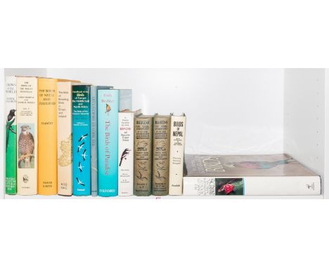
NO RESERVE Birds.- Clancey (P. A.) The Birds of Natal and Zululand, first edition, colour plates, illustrations, folding map at end, bookplate of Bernard King, dust-jacket with some light spotting, adhesive remains to upper flap, Edinburgh & London, 1964 § Fleming (Robert L. Snr.) & others. Birds of Nepal, second edition, full-page illustrations, dust-jacket with abrasion marks to flaps, 1979 § Stockelbach (Lavonia) The Birds of Shakespeare, 30 tipped-in illustrations, [1953], occasional light spotting, original cloth, lightly rubbed, dust-jackets, all but first with a few small chips to extremities and light surface soiling; and others birds, v.s. (12)

Lot 7
America.- Missouri prospectus.- Moore (Thomas, Boston based lithographer and publisher, active 1830s) Missouri City, lithographed city plan of the proposed new town that was planned to prosper from the riches of the nearby Iron Mountain Lode in St. Francois County, and shows St. Louis, a convergence of railroads and roads including the Kickapoo Rail Road, with inset map of the 'State of Missouri' in the lower left corner, and various vignettes, lithograph, on wove paper without watermark, 605 x 920 mm (23 3/4 x 36 1/4 in), several old folds with repairs verso and associated splitting, handling creases, rough edges, some scattered spotting, browning and surface dirt, residual label in upper right corner margin, unframed, [circa 1836].


Lot 192
A quantity of books to include various bound 18th and early 19th century music sheets, Dante Gabriel Rosetti's The Blessed Da Mozel illus. by Byam Shaw, Cicely Mary Barker - Spring Songs with Music from Flower Fairies of the Spring, books on architecture and The English House, Hoppus's Practical Measurer, Bartholomew's Contour Motoring Map of France, Elegant Extracts on useful and entertaining Pieces of Poetry new edition, London printed for Charles Dilly 1790, and others Location:


Lot 545
9 10 38 Teblitz ( Now Teplice) -The Large Red Map shows the Greater German Reich including the Sudatenland. Sudatenland became an object of Nazi expansionist policies and was ceded to Germany as a result of the Munich Agreement of September 1938. In 1945 the area was returned to Czechoslovakia. Good condition. All autographs come with a Certificate of Authenticity. We combine postage on multiple winning lots and can ship worldwide. UK postage from £5.99, EU from £7.99, Rest of World from £9.99


Lot 105
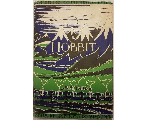
Tolkien (J.R.R.) The Hobbit, 2nd edition, 15th impression, London: George Allen & Unwin, 1965, illustrations by the author, a few minor spots, map endpapers, original cloth, light partial fading to spine, price-clipped dust jacket, small areas of worming head and foot, slight toning and spotting to spine and front panel, 8vo QTY: (1)

Lot 11
Teichman (Eric). Travels of a Consular Officer in North-West China, 1st edition, Cambridge: CUP, 1921, 2 folding maps contained in rear pocket, half-tone illustrations, inscribed in pencil to "Mr Teesdale, from the author, Sept. '21", original cloth, joints splitting, damp stains to covers, 8vo, together with Affairs of China. A Survey of the Recent History and Present Circumstances of the Republic of China, 1st edition, London: Methuen, 1938, map illustrations, original cloth, spine a little darkened, 8vo, inscribed by the author to Mr Teesdale, plus Scott (Robert Falcon). Scott's Last Expedition, 2 volumes, 4th edition, London: Smith, Elder & Co., 1914, maps and illustrations, some spotting, small bookplates of Sidney Frederic Harmer (1862-1950, zoologist and President of the Linnean Society 1927-31), top edge gilt, original cloth, some fading to spines, one or two stains, 8vo, with others including John Hunt's The Ascent of Everest, 1st edition, 1953, signed by the author, and A Journey to Alaska in the Year 1868: being the diary of Emil Teichmann, edited with an introduction by his son Oskar, Kensington: Cayme Press, 1925, limited edition 51/100 QTY: (15)

Lot 13
Willis (N. P.). American Scenery; or Land, Lake and River, Illustrations of Transatlantic Nature, from Drawings by W. H. Bartlett..., 2 volumes, George Virtue, 1840, portrait frontispiece, additional decorative titles, contents, preface and engraved map by W. Hughes with contemporary outline colouring, 117 (complete as lists) uncoloured engraved views, occasional spotting and staining throughout, presentation label to front pastedown of volume 1, contemporary ownership signature to the pastedown of volume 2, contemporary green cloth with morocco gilt labels to the spines, bumped and a little rubbed, 4toQTY: (2)
-
108737 item(s)/page