We found 109198 price guide item(s) matching your search

Refine your search

Year

Filter by Price Range
  • List
  • Grid
  • 109198 item(s)
    /page

Lot 3489

A collection of cotton celebration hankies, 100% cotton, dated 1897, depicting an elderly Victoria, Empress of India, inscription 'Long Live Victoria', flags of India, red cotton background and crowns in each corner, approx. 22" x 23" (one edge frayed). Also a larger hankie depicting a girl in native dress playing a tambourine in red/gold costume, blue background with stars and crescent moon, frieze running round the hemline. A blue printed hankie on a cream background showing a map of the world, shows the extent of the British Empire in 1886, 30" x 25", image of Boadicea with a Commonwealth country in each corner (small stain near Australia). (3)

Lot 3084

Robert Morden - A hand coloured map of Nottinghamshire 1695 - In frame.

Lot 3041

A collection of mixed watercolours to include; seaside, mountain etc scenes. Including a signed late 19th century watercolour of Snowden, another of Whitby Harbour, an embroidered map of The British Empire etc. (5)

Lot 222

UNFRAMED MAP OF THE MANCHESTER SHIP CANAL. APPROX. 43 X 151CM USED CONDITION, TEARS AND WEAR TO AREAS

Lot 337

M. BUTTS, THREE-DIMENSIONAL BRONZED FIBREGLASS MAP OF INVERCLYDE, CIRCA 1981 signed and dated167cm high x 222cm wide

Lot 405

Assorted Australian and New Zealand Silver Proof Coinage; 7 coins across 6 boxes comprising; New Zealand, Queen Elizabeth II 95th birthday 1oz silver proof coin 2021; Australia, Year of the Dragon pure silver 1oz coin 2012; pure silver 1oz kangaroo 2017; Australian map shaped pure silver 1oz kangaroo 2013; Queen Mother celebration silver proof coin 2002 (no certificate); and, Australian silver kangaroo numismatic set, comprising 2x 1oz pure silver coins 2012; all coins are encapsulated and boxed with certificates unless previously mentioned and with outer cardboard packaging

Lot 118

WW2 British Home Guard Manuals, booklets, documents and regulations. This includes a spring backed binder used by J S Morris of E Company, 2nd City of London, (Civil Service) Royal Fusiliers Home Guard. It contains the winter training syllabus 1943-44, a hand drawn map of the Berkeley Square Patrol Area of Mayfair and a menu for the Farewell Dinner for No.1 Platoon of E Company at the Chandor Hotel St Martin’s Lane. Also included are coloured sectioned drawings of the No.68, No.73 and No.74 Grenades. The Home Guard Proficiency manual contains drawings of Home Guard weapons and German weapons (11 items)

Lot 38

WW1 American Officers Medal and Paperwork Grouping of 2nd Lieutenant Thomas C Chalmers 26th Yankee Division, good set consisting of his allied victory medal with four battle bars, metal insignia, cloth divisional patch, divisional medal, photographs and complete service history of 2nd Lieutenant Thomas C Chalmers who served with the US 26th (Yankee) Division. A railwayman serving with the National Guard, he landed in France on 18 October 1917. He was commissioned into the US 101st Field Artillery in August 1918. The collection also includes his birth certificate 1888 and death certificate 1947, and a captured German map of the St Mihiel area.

Lot 99

Books - The Waterloo Roll Call, second edition 1904; General Regulations and Orders (1804) once the property of a Lt Colonel in 13th Light Dragoons; Standing Orders of the 7th Regiment of Hussars (1853); The Campaigns of Paris 1814 and 1815 by P F F J Giraud (published 1816) fold out map to front; An Abridgment of the Regulations for the formation and movements of the Cavalry (1833); A Manual for Volunteer Corps of Cavalry (1803); Standing Orders for the Carabineers or Vith Regiment of Dragoon Guards (1861); Short History of the 4th Queens Own Hussars by Major Edwards (1935); Standing Orders of the 4th Queens Own Hussars (1934) and a well worn and early Standing Orders (no visible date). Various conditions, some rebound and some ex libris.

Lot 493

A circular emblem with a raised five pointed star, four holes for fixing and small tablet of Japanese script, 13.5cm wide. With a 's heet B' map of Burma, Siam , French Indo China and China, printed onsilk 62cm x 94cm. According to family tradition these items were 's ouvenired' by a Robert Sorby of the 8th Indian Cavalry who apparently fought with the rank of Major with the 101st Independent light tank squadron. This unit had exchanged their horses for tanks prior to Imphal, and Major Sorby's wife suggested a rocking horse as their insignia as this represented a form of mechanized horse. His tank took out a Japanese tank, possibly at the Battle of Imphal in the Spring of 1944 which was fought between the Japanese and British and Indian forces when the Japanese were attempting to invade British India. *CR Surface issues, appropriate signs of age as might be expected. The image of Major Sorby has been supplied by the family and there is not a printed copy included in the lot. Map showing signs of use with holes and staining.

Lot 555

An American nail art trunk with a sliding three panel lid, the front with a U.S. eighth air force symbol in round headed brass nails, the sides and reverse with similar motifs, on small casters, 32cm high, 67cm wide and 30cm deep. A Second World War 's weetheart' box worked for 'Helen' from the 'Gold Coast 1945' and with an American Air Force badge, map of Africa and Elephant standing by a palm tree, heart shaped, 33cm x 29cm , 9cm high, with a single key. A black painted trunk marked to the front 'Army Staff Sargt R.F. Brownbill A.O.C. Jamaica' and to each end 's argt Major R F Brownbill RAOC' with two keys 33cm high, 77cm wide and 41cm deep. (3). *CR Mixed states, mostly in good condition.

Lot 160

An early Tunbridge ware whitewood print and map decorated circular pin cushion, the slightly domed sides divided by purple silk infill with bow suspension, one side with a colour printed map of the coastline from Shoreham to Newhaven centred by Brighthelmston (the name Brighton being adopted in the early 19th Century), the obverse inscribed 'Accept This Little Gift from me and may you ever happy be', within a ball border, 5.2cms dia. 

Lot 385

A rare colour printed silk pin disc map of 'Asia', one side with titled colour map the obverse titled 'Asia' with details of mileage, population, seas, etc., near mint, 5.5cms.

Lot 388

A rare silk pin disc one side with a colour printed map of Scotland, the obverse England, the former inscribed to edge 'R. Miller, 24, Old Fish St', losses mostly to the England map around the edges, pin stuck edge, 5.2cms dia.  † Richard Miller's premises were close to the Church of St. Mary and South and East of Paul's Church Yard, London. As well as maps he published children's books and his business was at its zenith in the 1820's. His catalogue published in the back of some of his books include games and jigsaws and 'Fancy Articles' including 'Satin Medallion Pincushions' for a shilling 'that feature portraits of the Royal Family and other famous persons from Lord Nelson to worthy divines copied from the subjects on the preceding list of prints'.

Lot 464

A French cardboard sewing box, circa 1850, of rectangular form in fancy printed paper with floral oval print to lid. Lid interior with mirror over box base with pin cushion and two floral print decorated lids, contents including miniature hat and bonnet, water colour map of South America signed 'Ann Place March 7 - 1857' and other pieces, 20 x 12 x 4.2cms. 

Lot 508

A sampler map 'Map of England Sophia Brown 1788', counties outlined and named, the embroiders details in a leaf and floral cartouche, part of Scotland, Ireland and French coast, small loss to bottom left, in a later glazed frame, 59 x 50cms. 

Lot 516

A sampler map of England and Wales 'Mary Woresays Work 1805', named counties, coast of France and Ireland, compass, lion and shield in floral circular cartouche, some staining, one small moth nip, 31 x 38cms, in verre eglomise mount in period frame. 

Lot 663

A rare printed silk monochrome needle book and a similar pin disc both relating to the early Brighton trade, the needle book with a circular image titled 'The Chain Pier Brighton', to the obverse a circular map titled 'Environs of Brighton', pink paper interior with original graduated flannels, 7.5 x 5.5cms, the pin disc again with circular map 'Environs of Brighton', and to the obverse 'The Chain Pier Brighton', wear to edges, 5.4cms dia.     (2)

Lot 765

An American limited edition heavy gauge gold thimble to commemorate 'Diana', the ground of hearts embellished with oval portrait and '1961-1997', and with a map of Great Britain in variant gold below a broken rose branch, stamped '585/G/KSA??', interior rim engraved 19/36.     From the collection of Celia Barrington

Lot 120

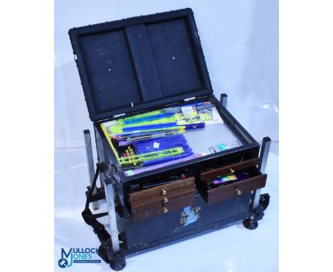
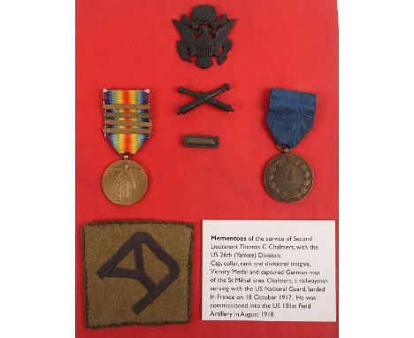
Coburn (Alvin Langdon, 1882-1966). Manchester & the Sea, [Manchester: Cloister Press], c. 1920s, 10 reproductions of Coburn photographs on rectos and versos of 5 leaves, folding map printed in red, gilt and black at rear, original grey card wrappers with title label pasted to upper wrapper and photograph reproduction notice tipped onto inside front cover, slim 4to (235 x 180 mm), VG, together with:Coburn (Alvin Langdon). Manchester & the Sea, [Manchester: Cloister Press], c. 1920s, 10 reproductions of Coburn photographs on rectos and versos of 5 leaves, folding map printed in red, gilt and black at rear, original grey card wrappers with title label pasted to upper wrapper and photograph reproduction notice tipped onto inside front cover, slim 4to, with:Nevill (Ralph, & Jerningham, Charles Edward). Piccadilly to Pall Mall. Manners, Morals and Man, 1st edition, London: Duckworth & Co, 1908, two photogravures after Coburn, a few light spots, top edge gilt, original red cloth gilt, rubbed with a few marks, 8vo, andStevenson (Robert Louis). Edinburgh, Picturesque Notes, 1st edition, London: Rupert Hart-Davis, printed by the Chiswick Press, 1954, 23 black and white illustrations after Coburn, original white paper-covered boards, spine lettered in silver, dust jacket, lightly rubbed and marked, 8vo, with other photography books and catalogues, etc., relating to Coburn, including volumes 1, 2, 8, 12, 21 and 23 of The Novels and Tales of Henry James (1st Collected edition, Charles Scribner's, 1907-09), each one of 156 copies with photogravure frontispiece, and two copies of The Manchester Reform Club, 1871-1921 (privately printed, 1922)QTY: (24)

Lot 382

* Durham Mining Archive. An archive of mostly manuscript accounts and papers relating to collieries in Durham and the North East, 18th/19th century, including a manuscript account book containing 355 pages of accounts,1742-69, for colliery expenses on numerous sites including: Etherley, Bushblades, Tanfield Moor, Heaton, etc., computations of 'what will work one score of coal' including 'candles & oyl', the cost of sinking a new pit, servants wages, rent, etc., one pen and ink estate plan and one other rough sketch, a few leaves detached, original half morocco, some wear, 4to, together with a manuscript leaf showing Andrews House Success Pitt Bill ending 11 March 1767, slightly toned, 31.5 x 20 cm, framed and glazed, plus numerous other 19th-century deeds and agreements including: Report and Valuation of Colliery Coke Works...at Blaydon, Swallwell, Derwenthaugh, Bill Quay and Jarrow, belonging to Geo. Hepple Ramsay Esq., rate book from Winlaton, two account books from 1826 relating to establishing the new waggon way between Crawcrooke and Derwenthaugh, a Durham Coalfield map sectionalised on linen, plus a group of vellum deeds and other legal documents relating mostly to property and lands in South Shields and some in Middlesex, etc.QTY: (a carton)

Lot 170

GOLF, golf course selection, inc. course guides, Garforth, Turnberry, Woodhall, Easingwold, Gainsborough, Belton Park, Cavendish; Kingsbarns map, photographs & course guides; Good Golf Guide softback, East Lothian golf booklet, Golf World Golf Course of GB & Ireland guide etc., G to EX, 38*

Lot 517

ADVERTISING, booklet for excursions, now loose pages, inc. Steam Yacht 'Swift' Windermere, Inner Circular Tour, Grange & Windermere, Redbank & Grassmere, The Four Lakes, Coniston To Coniston, Round The Langdales, Ullswater, The Six Lakes etc., colour picture to front, information inc. fares, map etc. to reverse, FR (2), o/w G to VG, 23

Lot 656

OGDENS, complete, part sets & odds, inc. complete (1), Jockeys And Owners Colours; part sets & odds, Derby Entrants 1928 & 1929, Prominent Racehorses of 1933, Owners Racing Colours And Jockeys, A.F.C Nicknames, Boxing, Sectional Cycling Map, Jockeys 1930, Famous Rugby Players, Football Caricatures, Prominent Cricketers Of 1938 etc., FR to G, 530*

Lot 180

A Cary's linen backed map - reproduction of his large map of England and Wales, with part of Scotland - 75.5cm x 63cm

Lot 191

A quantity of Batholomew's road maps, 2 miles to the inch, England, Wales and Ireland contained in a leather map case "England" with carrying handle

Lot 394

Framed map of Liverpool engraved by T Starling printed in 1836 by Baldwin & Gaddock, 40 x 30 cm, 20 mm tear to top right ( please see photo with tape measure) and a slight crease to middle right of map and very small crease to the right bottom of map, frame is in good condition, no sign of foxing etc. Not available for in-house P&P

Lot 249

Johannes Blaeu (1596 - 1673), an engraved and coloured two-page map, Hampshire, Hantonia Sive Southantonenensis Vulgo Hantshire, 44cm x 52.5cm

Lot 442

Jan Jansson, an engraved and coloured two-page map, Leicestershire, Leicestrensis Comitatus cum Rutlandiae vulgo Leicester & Rutlandshire, 45.5cm x 57cm

Lot 535

Wales - John Speed (1551/52-1629), The Countye (sic) of Monmouth [...], [London]: [...] to be solde (sic) in Popes head Alley, against the Exchange by John Sudbury, and Georg Humble, 1610, two-page map, English text to verso, engraving, ?later hand-colouring, 38cm x 51cm, [1]

Lot 611

A COLLECTION OF TEN WOODEN JIGSAWS INCLUDING E. WALLIS' 'THE ENCHANTED CASTLE OF PERSPECTIVE RUN MAD' (10)Mainly 19th Century Also including four other jigsaws published by E. Wallis of Skinner St. London including 'Improved and Dysected Map of the World' and 'Improved Dysected Map of Europe'; Together with two published by John Betts including 'A Chain of Events In English History' and 'A New Dissected Map of England', an example published by Darton & Harvey and two further examples, all in original boxesCondition Report:All boxes with wear, marks, chips, warping etc consistent with age. Some with loose or broken sides or lids. For completeness please see additional images of individual puzzles. Some with marks or damage to pieces. Some with warping etc as expected with age and use. 

Lot 601

Man Lp 1972 with Welsh map artwork cover along with a velvetone record brush

Lot 89

early 1900s newspapers, A 1800's linen pocket map and small amount cigarette cards

Lot 437

'Antarctic Research, A Review of British Scientific Achievement in Antarctica' Ed. Sir Raymond Priestley, Adie and Robin, published by Butterworths, 1964, signed by Priestley and Fuchs, complete with map, portfolio and card sleeve (1 Vol) (Please note condition is not noted. We strongly advise viewing to satsify yourself as to condition. If you are unable to view please request a condition report, which will be provided in writing).

Lot 99

Thomas Jefferys,  British c.1710/19-1771- Plan of the Town and Citadel of Palais, the Capital of Bell'Isle; hand-coloured engraving, 16.1 x 23.3 cm. Provenance:  with The Boydell Galleries, Liverpool.  Private Collection, UK. Note:  Jefferys was a prolific and prominent cartographer and 'Geographer to King George III'. He was particularly well-known for his maps of North America, produced in the mid-18th century, when territorial disputes were raging across the continent. The present map depicts Le Palais, the main town on the island of Belle-Île-en-Mer off the Breton coast, which is itself the second largest of the islands off mainland France, after Corsica. The citadel was built in 1549, and was redesigned in the late 17th century by Sébastien Le Prestre de Vauban, military engineer to Louis XIV. This map is related to the British invasion and occupation of the island from 1761 to 1763. 

Lot 231

Great Britain, Great Exhibition, Hyde Park, 1851, Juror’s Medal, a copper award by W. Wyon and G.G. Adams, conjoined busts of Victoria and Prince Albert left, dolphins below, trident behind, rev. seated figure of Industry attended by Commerce, receiving wreath of Fame, edge named (Sir H.T. de la Beche), 64mm (Allen A040; BHM 2464; Roehrs 1719, this piece). Good extremely fine £600-£800 --- Importation Duty This lot is subject to importation duty of 5% on the hammer price unless exported outside the UK --- --- Provenance: A Collection of 1851 Great Exhibition Medals, DNW Auction 45, 1 March 2000, lot 598; E. Roehrs Collection, DNW Auction M11, 13 July 2011, lot 1719 Sir Henry Thomas de la Beche, CB, FRS (1796-1855), geologist and chairman of the Mining, Quarrying, Metallurgical Operations and Mineral Products jury at the Great Exhibition. De la Beche’s lifelong interest in geology was first kindled as a boy when he lived in Lyme Regis. He became a Fellow of the Geological Society of London in 1817 and was elected as its president in 1847. He wrote several works on geology and was the mastermind behind the compilation of the Ordnance Survey map of Britain, a project begun in 1832. He founded the Geological Museum in Jermyn Street, London, opened by Prince Albert in 1851, and funded the issue of two medals – the de la Beche medal of the School of Mines (BHM 2264), instituted as an annual prize in 1857, two years after his death, and the de la Beche Good Conduct Medal of 1841 (BHM 2002), awarded to employees on his paternal estate at Halse Hall, Clarendon, on the island of Jamaica.

Lot 238

Jamaica, Jamaica International Exhibition, 1891, a maroon leather Season Ticket, the cover decorated in gilt with arms and crown above world map, printed with conditions, etc. inside, numbered 1011, and signed by owner (Thos. [-------]), 73 x 50mm. Hinge worn, otherwise very fine, extremely rare £200-£260 --- Importation Duty This lot is subject to importation duty of 5% on the hammer price unless exported outside the UK --- --- Provenance: R. Brandon Collection, DNW Auction 122, 2-3 April 2014, lot 1032 (part)

Lot 101A

A LARGE VINTAGE L.R ROBERTS & CO MAP OF MANCHESTER

Lot 1556

A LARGE VINTAGE 'PHILIPS MILESTONE MOTOR MAP'

Lot 380

A HAND ANNOTATED MAP OF THE FIRST BATTLE OF MARNE DATED 1914, 40 X 41CM, FRAMED AND GLAZED

Lot 383

A RARE WORLD WAR II A.R.P. FOLDING BOMB PLOTTING MAP OF MANCHESTER, 194 X 194CM

Lot 387

A Selection of Islay and Islands Whisky miniatures to include: Lagavulin 16 Year Old White Horse bottling, 2 x Laphroaig 10 Year Old, Highland Park 12, Bunnahabhain 12, Talisker 10 Map Label, Isle of Jura 10 

Lot 111

Interesting vintage photograph of Cowes Parade, 1935, showing the pier and selection of vintage vehicles with many folk milling about. 28x37.5cm approx. Framed and glazed. together with framed photograph of QEII arriving in Sydney Australia 1978, signed by Captain Robert H Arnott, Master QEII. 26x38.5cm approx. Together with map of the Shore Savill Line, track chart. 40x95cm approx. Framed and glazed. (3) (B.P. 21% + VAT)

Lot 156

Small rebound in leather with marble boards 18th/19th century volume 'Swansea Guide', a small inlaid box for playing cards (Canasta) with two penguins decorating the hinged lid, an early 20th century Troughton & Simms miner's dial 9.5cm diameter approx. in fitted leather case, a 219th century papier mache spectacle case decorated with portrait of a woman, travelling map of Glamorgan, small porcelain figural brush and a miniature barrel from the teak of HMS Warspite etc. (B.P. 21% + VAT)

Lot 167

Vintage educational map, the Counties of Wales 1974 together with another education learning resource, The Weather Explained, both by TVA Products. (2) (B.P. 21% + VAT)

Lot 1287

Map Fishing Tackle Box Seat, with a selection of coarse fishing accessories inside of line, line winders, bait boxes, lead weights Waymaster scales, Snowbee storage jar, the tackle box has signs of wear - one drawer wooden front has a repair to it

Lot 1363

Shooting and Fishing in Lower Brittany, A Complete and Practical Guide to Sportsmen Kemp, John Published by Longmans, Green & Co, London, 1859 - with map to front

Lot 1411

3x Various Modern Rods - includes Map Dave Harrell GB light quiver 10ft 6in 2 piece carbon rod shrink wrap to handle, for reel lines 1.5-3lb good, a Middy X-flex 4G baggin distance feeder rod 11.7-12.7ft with extension and quiver tip, plus a Middy triple X 10ft 2 piece carbon feeder rod duplon and cork handle in MOB (3)

Lot 304

1834 The Angler in Ireland or an Englishman's rambles through Connaught and Munster during the summer of 1833 - in 2 Vols, quarter leather binding with marbled boards, with 2 plates and one map, G for age

Lot 440

Map Pole Roller in its original canvas case - light used condition

Lot 641

Fishing Nets & Landing Nets keep nets, to include 2 net handles and 5 net heads by Keenets conserva net, Map pan landing net, Middy match black LTX x 2, Maver power Carp, a Maver 3m shake dry keep net, all within a RT Match net bag,

Lot 430

After Christopher Saxton. A 17thC coloured engraved map of the East Riding of Yorkshire, 21.5cm x 26cm.

Lot 13

Excellent volume from Hetzel's French edition Au Portrait Colle Voyages Extraordinaires by writer Jules Verne published between 1892-1895. It includes the novels L'Etoile du Sud (The Vanished Diamond, or The Southern Star) with 60 illustrations and one map, and L'Archipel en Feu (The Archipelago on Fire) with 49 illustrations and two maps by Benett. Includes the new catalogue for 1884-1886. Sticker on verso of front cover: Librairie Laurencier, Bordeaux, France. Collection Hetzel, Bibliotheque d'Education et de Recreation, published by Pierre Jules Hetzel et Cie, Paris. Artist: Jules Verne (French 1828-1905)Issued: 1892Dimensions: 7.25"W x 11"H x 1.40"DManufacturer: HetzelCountry of Origin: FranceProvenance: Collection of Marie-Claude Lalique Condition Good. Some soiling on the end catalogue and minor foxing. Some color loss on cover.

Lot 25

Beautiful volume from Hetzel's French edition Au Portrait Colle, Voyages Extraordinaires by writer Jules Verne published between 1892-1895. It includes the novel L'Ile a l'Helice (The Floating Island, or The Pearl of the Pacific) with 80 illustrations by L. Bennet including 12 chromolithograph engravings, one color map and two in black & white. Includes the new catalogue for 1895-1896. Inscribed on verso of cover: A ma cousine Jeanne Hesse, 1 Janvier 1896. Collection Hetzel, Bibliotheque d'Education et de Recreation, published by Pierre Jules Hetzel et Cie, Paris. Artist: Jules Verne (French 1828-1905)Issued: 1895Dimensions: 7.25"W x 11"H x 1.40"DManufacturer: HetzelCountry of Origin: FranceProvenance: Collection of Marie-Claude Lalique Condition Very good. Some color loss and minor tear on upper part of spine.

Lot 26

Great volume from Hetzel's French edition Au Portrait Colle Voyages Extraordinaires by writer Jules Verne published between 1892-1895. It includes the novel P'tit Bonhomme (Foundling Mick) with 85 black & white, 12 color illustrations and one map in color by Leon Benett. Includes the new catalogue for 1893-1894. Collection Hetzel, Bibliotheque d'Education et de Recreation, published by Pierre Jules Hetzel et Cie, Paris. Artist: Jules Verne (French 1828-1905)Issued: 1893Dimensions: 7.25"W x 11"H x 1.50"DManufacturer: HetzelCountry of Origin: FranceProvenance: Collection of Marie-Claude Lalique Condition Good. Some foxing. Color loss and tears on lower parts of spine. Areas of color loss on front cover.

Lot 31

Handsome volume from Hetzel Au Globe Dore French edition of the Voyages Extraordinaires by writer Jules Verne. This type 3 includes the novel P'tit Bonhomme with 85 illustrations by Louis Bennet with 12 large chromolithographs, and one color map. Vibrant red cover with rich gild designs. Collection Hetzel, Bibliotheque d'Education et de Recreation, published by Pierre Jules Hetzel et Cie, Paris. Artist: Jules Verne (French 1814-1905)Issued: c. 1901Dimensions: 7.25"W x 11"H x 1.50"DManufacturer: HetzelCountry of Origin: FranceProvenance: Collection of Marie-Claude Lalique Condition Very good. Small color loss on center left cover.

Lot 41

Excellent volume from Hetzel's French edition Aux Initiales Dorees, JV, Voyages Extraordinaires by writer Jules Verne. It includes the novel Le Rayon Vert (The Green Ray) with 44 illustrations and one map by Leon Benett. Includes the catalogue 1882-1883. Sticker on recto of cover: Ancienne Librairie Veuve Duterque, A. Pallant, Successeur. Inscribed: 1er Janvier 1888, Souvenir de Madame Berez. Collection Hetzel, Bibliotheque d'Education et de Recreation, published by Pierre Jules Hetzel et Cie, Paris. Artist: Jules Verne (French 1828-1905)Issued: 1882Dimensions: 7.25"W x 11"H x 0.80"DManufacturer: HetzelCountry of Origin: FranceProvenance: Collection of Marie-Claude Lalique Condition Very good. Minor stain drops on lower back cover.

Lot 44

Excellent volume from Hetzel's French edition Aux Initiales Dorees, JV, Voyages Extraordinaires by writer Jules Verne. It includes the novels L'Etoile du Sud (The Vanished Diamond, or The Southern Star) with 60 illustrations and one map. Catalogue CH for 1885. Collection Hetzel, Bibliotheque d'Education et de Recreation, published by Pierre Jules Hetzel et Cie, Paris. Artist: Jules Verne (French 1828-1905)Issued: 1884Dimensions: 7.25"W x 11"H x 0.80"DManufacturer: HetzelCountry of Origin: FranceProvenance: Collection of Marie-Claude Lalique Condition Very good. Minor foxing. Title page partially loose.

Lot 5

Great volume from Hetzel's French edition Au Portrait Colle Voyages Extraordinaires by writer Jules Verne published between 1892-1895. It includes the novel Deux Ans de Vacances (Two Years Vacation) with 91 illustrations by Benett and one color map. Includes the new catalogue for 1893-1894. Collection Hetzel, Bibliotheque d'Education et de Recreation, published by Pierre Jules Hetzel et Cie, Paris. Artist: Jules Verne (French 1828-1905)Issued: 1894Dimensions: 7.25"W x 11"H x 1.40"DManufacturer: HetzelCountry of Origin: FranceProvenance: Collection of Marie-Claude Lalique Condition Good. Some foxing. Minor color loss on cover.

Lot 55

Rarely offered volumes from Hetzel's French edition Aux Initiales Argentees, Voyages Extraordinaires by writer Jules Verne. It includes the novel Keraban-Le-Tetu (Keraban the Inflexible) in two volumes with one map and 101 illustrations by Leon Benett. Includes catalogue 1894-1895. Sticker of owner on verso of cover: Eric Weissenberg. Collection Hetzel, Bibliotheque d'Education et de Recreation, published by Pierre Jules Hetzel et Cie, Paris. Artist: Jules Verne (French 1828-1905)Issued: 1894Dimensions: 7.50"W x 10.75"H x 0.80"DManufacturer: HetzelCountry of Origin: FranceProvenance: Collection of Marie-Claude Lalique Condition Very good.

Loading...Loading...
  • 109198 item(s)
    /page

Recently Viewed Lots