We found 109198 price guide item(s) matching your search

Refine your search

Year

Filter by Price Range
  • List
  • Grid
  • 109198 item(s)
    /page

Lot 587

WILLIAM KIP: MAP OF DORSET, COLOURED

Lot 589

RICHARD BLOME (1641-1705) 'A MAPP OF YE COUNTY OF DORSET' Thomas Taylor edition c. 1715, hand coloured with table of divisions and hundreds upper left, 19.5cm x 25.5cm; together with a map of Norfolk (2) . Provenance: The Map House, Knightsbridge, London

Lot 590

A 19TH CENTURY MAP OF DORSET and two other maps

Lot 592

A MAP OF SOMERSET SHIRE DIVIDED INTO HUNDREDS by Eman. Bowen

Lot 593

A 19TH CENTURY MAP OF WILTSHIRE/DORSET on a sprung brass roller, and a mahogany map-roll box labelled 'Wiltshire' (NOTE: the two are NOT compatible)

Lot 484

After Jan Jansson, Leicestrensis comitatus cum Rutlandia, a hand-coloured map, 44x56cm; together with a quantity of contemporary floral prints, print of The Town Hall, Leicester, etc.

Lot 104

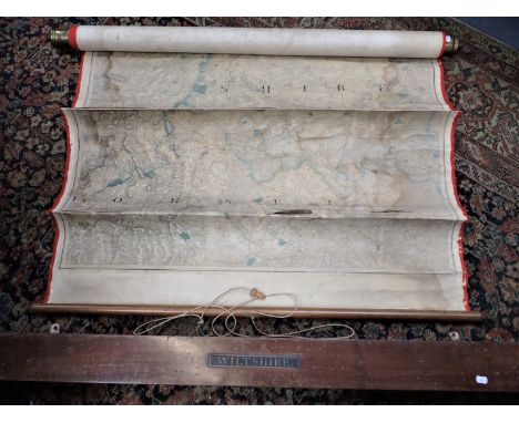
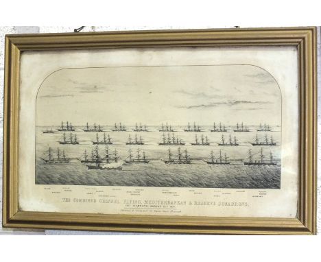
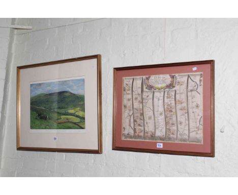
A framed black and white print 'The Combined Channel, Flying, Mediterranean & Reserve Squadrons, off Plymouth, August 13th 1871', 130 x 52.5cm, pub. Groom & Co. 83 Union Street, Plymouth, after Eman Bowen, 'Wiltshire Divided into its Hundreds', a framed map (in poor condition) and a coloured print of a racehorse and jockey, (a/f), in maple frame, (3).

Lot 171

W. Sheardown (Publisher) : This Map of the County Round Doncaster, steel engraving, with some hand colouring, 1805, unexamined out of frame, 60 cm x 78 cm, framed.

Lot 231

A hand coloured ordinance survey map of the North of England and The Borders, 72cm by 56cm

Lot 78A

A group of pictures and prints, framed map of Northumberland, R Ritson Nichol watercolour of St Cuthbert's Church dated 1982 etc

Lot 113

Ordnance Survey map books including 1922 cloth maps, John Bartholomew 1939, Philip's Atlas, together with metalwares.

Lot 252

German Third Reich satchel, with thirteen stamped map squares.

Lot 319

Robert Morden, framed map of Suffolk, 41cm by 47cm including frame.

Lot 324

Framed Whitby to Durham map and Piers Browne limited edition print, Baling Up in Walden, Off Wensleydale, signed, titled and numbered 58/100 in pencil in the margin (2).

Lot 204

STAFFORDSHIRE PORCELAIN HAND PAINTED & TRANSFER PRINTED ROCOCO DISH - having floral sprays against a green ground with interior printed map of Yorkshire, early 19th century, 9.5cms H, 26cms across

Lot 87

ROBERT MORDEN tinted map of North Wales, gilt framed print of the William Fawcett (1828) traditionally P & Os first ship and a pair of photographic prints of a coastal inlet and a rocky cove, 37 x 44cms, 14 x 22cms and 39.5 x 54.5cms measurements respectively

Lot 242

Barber's Isle of Wight with map and numerous engravings, together with other Isle of Wight related booksCONDITION REPORTsome in poor conditionplates missing in some books

Lot 247

An old geological survey map of the Isle of Wight, framed and glazed

Lot 327

Isle of Wight engravings together with a map

Lot 59

JOHANNES BLAEU - Vectis Insula - coloured map - 40cm x 50cm - framed and glazed

Lot 737

A sundry lot including pipes, horns and linen WW2 escape map, military buttons etc

Lot 744

A Russian map of the River Thames, framed and glazed

Lot 772

A collection of pictures and paintings including old Isle of Wight map

Lot 1847

A collection of various cigarette cards, a vintage Econasign stencil outfit, a map of North Essex, pocket cyclist maps, a book of monochrome portrait prints etc.

Lot 145

JOHN SPEED MAP OF SUSSEX MEASURES 53CM X 39CM INNER FRAME - IN PERFECT CONDITION

Lot 1379

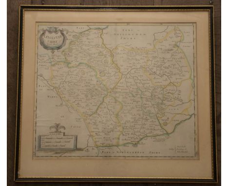
Collection of framed prints, to include a fire insurance 'Proposals' notice from Salop Fire-Office, 1 January 1783, with woodcut trade-mark and manuscript policy holder/number; a Robert Morden map of Leicestershire; a steel-engraving of Stafford; a colour woodcut of Aston Hall; two modern signed prints of Stafford and Leek. Together with a modern unframed map of Medieval Shrewsbury (7)

Lot 1381

Collection of nine framed prints, comprising: Eli Marsden Wilson (1877-1965), Poplar Hawk Moth, etching, signed in pencil l.r., 10.5cm by 12cm (plate-mark); G. F. Scotson Clark, 'Herbert Campbell, Running to Waist', colour woodblock, 21.5cm by 18.5cm, Michael Lewis Gallery label verso; M. M. Rudge, York Minster from City Walls, etching, signed in pencil l.r., 19cm by 25cm (plate-mark); a copper-engraved portrait of French collector Claude de Bourdaloue, 1704, engraved by Nicolas de Largilliere after Nicolas Pitau the Younger, 41cm by 28.5cm; Robert Morden map of Shropshire, copper engraving on laid paper, 37cm by 43cm (not glazed); Pieter Van den Keere map of Hertfordshire, 9cm by 13cm; a hand-coloured etching of The Rivals, cartoon, by Marks, 12.5cm by 16.5cm; a black & white photograph of the Grierson Award for Best Short Film of the Year, bearing typed label verso, 'Presented to Sir Harold Wilson on the occasion of the first Grierson Day - 10th February 1977 - with appreciation of the Grierson Trustees for support and interest in the short film', signed by Basil Wright, Chairman, 23.5cm by 18.5cm; a modern colour print of a prize cow, 25cm by 27cm (9)

Lot 1396

An 18th century framed glazed map of Warwickshire, hand coloured dated 1576 Leonardus Terwoordus anteur pianus incidebat 

Lot 1429

John Speed (1552-1629). Map of Suffolk, c.1676, hand-coloured copper engraving on laid/chain-lined paper, featuring armorial shields and inset view of Ipswich, published by Bassett & Chiswell, 39cm by 51.5cm. Framed and glazed recto & verso (both sides visible); some faint creasing, central fold reinforced verso

Lot 1430

Mercator & Hondius. Map of Beauvais in northern France, c.1638, hand-coloured copper engraving on laid/chain-lined paper, 38.5cm by 51cm. Framed and glazed recto & verso (both sides visible); clean and bright, a couple of small closed tears, central fold reinforced

Lot 1431

Saxton & Hole. Map of Buckinghamshire, c.1637, hand-coloured copper engraving on laid/chain-lined paper, 29cm by 30.5cm, framed & glazed

Lot 1432

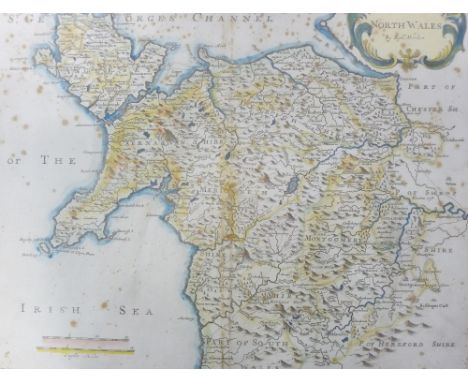
Maps. Mixed collection, predominantly 19th century, a few earlier examples, mostly English counties, some Europe. To include Bowen, Wallis, Archer, Moule, Walker, Hall, and others. Includes a double hemisphere map of the world by Collins, and a map of Bedfordshire by Robert Morden. Four framed & glazed, the remainder mounted in wrappers (35)

Lot 15

London Underground. Stingemore, F H. Pocket map of the London Underground, London: Waterlow & Sons Limited, June 1927. Printed in colours. 12.6cm by 14.7cm (unfolded). Well-preserved and bright

Lot 1543

A framed and glazed map of Warwickshire, c. 1800, T Kitchen.

Lot 2237

WW1 British Map of France dated 1914.

Lot 48

Gallichan (Walter M.) Fishing in Derbyshire and Around, first edition, map frontispiece, original cloth, gilt, 1905; Little (G.) The Angler’s Complete Guide and Companion, first edition, illustrated, original decorated cloth, n,d, [1881]; Traherne (Micheal) Be Quiet and Go A-Angling, first edition, illustrated, original cloth, dust-jacket, clipped, 1949; Discover Scotland, 4 vols, bound magazine, illustrated, The Sunday Mail, 1986, v.s (7)

Lot 56

Collection of maps, to include A Map of England and Wales for the Complete History of England, by T. Kitchin, n.d., 49cm by 41cm, linen-backed, creased; Greater Birmingham, lithographic, by Midland Educational Co. Ltd., n.d., some wear, 62cm by 74cm, various advertising verso; six small OS and similar maps of Cannock Chase and Colwich, Staffordshire, varying sizes, three being linen-backed; a map of Asia, by Edward Weller for the Weekly Dispatch Atlas, discoloured/worn (9)

Lot 607

A framed coloured map of Suffolk; together with a pencil signed engraving; a mahogany framed mirror

Lot 435

A framed map depicting Suffolk, showing railways and station names

Lot 609

Sebastian Munster, woodblock map, ‘Angliae Descriptio’, England and Wales, orientated to the east, Basel c.1540. Overall 32 x 40cm. Unframed.

Lot 655

Valk and Shenk, coloured engraving, Map of Glocestria, 42 x 52cm

Lot 77

A vintage school room map depicting Australia and the surrounding ocean, measuring approximately 180 cm x 200 cm.

Lot 1

A vintage garage tinplate sign for a Michelin Motoring Map 59cm x 89cm stains should remove and clean up

Lot 109

A selection of various prints and original art work including Map of Java architectural and family tree

Lot 113

A selection of map prints including Oxford and Westmorland

Lot 182

WW II, Japan, large military issue map of the Tokyo municipal area

Lot 669

COLOURED MAP OF NORTHAMPTONSHIRE, TOGETHER WITH A PLAN OF THE DELINEATION OF THE ANCIENT BOROUGH OF CAMBRIDGE, BOTH FRAMED AND GLAZED

Lot 779

COLOURED PRINT, MAP OF THE WORLD, IN EBONISED FRAME, 68CM WIDE

Lot 155

A full set of USA gold plated state quarters in 10 box's, first state quarters of the United states collectors map complete. Plus loose quarters

Lot 1119

John Ogilby (British 1600-1676): 'The Road from London to Newhaven', engraved strip map with later hand colouring pub. 1675, 33cm x 46cm

Lot 219

Jan Jansson, engraved map of Somersetshire, hand coloured, probably late 17th/early 18th century, framed, 38.5 cm x 52 cm

Lot 221

Robert Morden, late 17th/early 18th century, a coloured map of Herefordshire and another of Somersetshire, framed (2)

Lot 222

A Morden map of Hampshire and a Moll map of Hertfordshire, late 17th/early 18th century, hand coloured, framed, the first 42 cm x 36 cm, the second 30.5 cm x 19.5 cm (2)

Lot 1018

An early 19th century French engraved map of France with inset map showing the environs of Paris and key showing the Departements of France, 52x60cm

Lot 1021

William Berry - The Kingdom of France, Distinguished according to the extent of all its provinces and conquests in Spain, Italy, Germany, Flanders, Artois, Haynoult, Namur and Luxembourg provinces of the Low Countries, engraved map 56x87cm; together with La Royaune de France engraved map dated 1769, 48x66cm (2)

Lot 1022

The Post Roads of France, from the Map of Jaillot, published by Order of the Duke of Choiseul, engraving, later hand coloured, dated 1772, 48x59cm, together with Carte du Gouvernement de Normandie, engraved regional map by S Robert de Baugondy, 49x73cm (2)

Lot 1029

Folio of assorted sketches, drawings, to include various amateur watercolours, engraved county map etcCondition report: Red coated gentleman is a watercolour. Postage would be the standard £20. There is no obvious Scottish connection.

Lot 725

A box of miscellaneous items to include The Battle of Britain August to October 1940 An Air Ministry account of the Great Days booklet, Bomber Command book, War Office Notes on map reading, photograph album to include WWII examples, postcards etc

Lot 2075

A quantity of prints and paintings to include framed map of Carlisle, oriental pictures, an embroidery, two engravings 'The Black Friars at Newcastle' and 'Hulne Abbey in Northumberland', and three paintings of figures.

Lot 318

A late 18th / early 19th century hand-coloured two-plate engraving: 'View of Armitage Park' and 'View of Armitage Church', glazed gilt frame (later), together with a framed and glazed counties map of Aberdeen (2)

Loading...Loading...
  • 109198 item(s)
    /page

Recently Viewed Lots