We found 109182 price guide item(s) matching your search
There are 109182 lots that match your search criteria. Subscribe now to get instant access to the full price guide service.
Click here to subscribe- List
- Grid
-
109182 item(s)/page


Lot 1394
TULLY (R) Narrative of a Ten Years' Residence at Tripoli in Africa: from the original correspondence . . . comprising authentic memoirs & anecdotes of the reigning bashaw . . . also, an account of the domestic manners of the Moors, Arabs, and Turks. 2nd edition. folded map & 7 hand-coloured aquatint plates; old half calf & marbled boards, 4to. 1817. * Sotheron armorial bookplate; published with 2 more plates than the first (1816) edition.


Lot 1402
LIVINGSTONE (D. & C.) Narrative of an Expedition to the Zambesi and its Tributaries; and of the discovery of the Lakes Shirwa and Nyassa. 1858-1864. First Edition. folded frontis., 12 wood-engraved plates, text illus., (lacks the folded map); rebound cloth, gilt-lettered on spine, original gilt-pictorial upper cover laid-down. 1865.
![SCOTT'S LAST EXPEDITION - The PROSPECTUS] 'Antarctic Expedition for 1910'. (8)pp. unnumbered, the title is head of first p](https://cdn.globalauctionplatform.com/a4e68b87-45ef-46b8-80b1-a6c200a3e254/97e805c6-5704-4969-c929-b424a5093e23/468x382.jpg)
Lot 1446
SCOTT'S LAST EXPEDITION - The PROSPECTUS] 'Antarctic Expedition for 1910'. (8)pp. unnumbered, the title is head of first page, sewn, without wrappers, the explorer's name printed on last page - 'R.Scott/ September 15, 1909'. * a sketch map gives recent discoveries, 2 other illus., text includes 'plans for a prolonged southern journey'; the various values of dogs, ponies & motor sledge; the undertaking's scientific objectives; and a call for further funding. * not in Spence; together with a Receipt for a subscription received (£5) no. 424, with the British Antarctic Expedition's indelible stamp over the postage revenue penny stamp; and also with its 8 line typewritten covering note of thanks on the Expedition's headed notepaper (2nd February 1910) & signed 'R Scott'; Owing to the donor (Mrs. Ward, wife of the Master of Peterhouse, Cambridge) mistakenly having been given her husband's title & form of address, Scott writes an additional ms. 7 line note of further thanks & apology - ' Will you accept my personal thanks for your help and good wishes, I wish I had time to express my appreciation more fully . . . R. Scott'. Illustrated

Lot 1448
SCHEFFER (J.) The History of Lapland: wherein are shewed the original, manners, habits . . . of that people. First English Edition. pictorial engraved & printed titles, a map & 26 text engravings; contemp. calf (sometime rebacked with panelled spine), sm. folio. Oxford: at the Theater, 1674. * apparently with the first depiction of skiing in an English book. Illustrated

Lot 1386
HOSKINS (G.A.) Visit to the Great Oasis of the Libyan Desert; with an account . . . of the Oasis of Amun and the other oases now under the dominion of the Pasha of Egypt. First Edition. folded map & 20 lithographed plates (3 folded); blind-decorated & gilt lettered cloth. 1834. * includes 16pp. publisher's catalogue (July 1834).

Lot 1388
PHILBY (H. St. J.) The Empty Quarter: being a description of the Great South Desert of Arabia known as Rub' al Khali. First Edition. 33 photo. plates, coloured folded plan & 2 coloured folded maps; gilt cloth. 1933; PHILBY (H. St. J.) Sheba's Daughters: being a record of travel in Southern Arabia . . . First Edition. 47 photo. plates (1 d-page), large folded & coloured map, text illus.; gilt cloth, roy. 8vo. 1939.

Lot 1425
BIRD (I.) Unbeaten Tracks in Japan: an account of travels in the interior, including visits to the aborigines of Yezo and the shrines of Nikko and Ise. 2nd edition, 2 vols. frontispieces, coloured & folded map, num. text illus., half titles; publisher's catalogue; gilt & black pictorial cloth. 1880. * the author aka Mrs. Bishop (see lots 1427 & 1428).

Lot 1400
LONG (Col. C.C.) Central Africa: naked truths of naked people. An Account of Expeditions to the Lake Victoria Nyanza and the Makraka Niam-Niam, west of the Bahr-El-Abiad (White Nile). First Edition. mounted photo. frontis., folded & coloured map, 8 engraved plates & some text illus.; gilt & black pictorial cloth. 1876. * publisher's 24pp. catalogue (Apr. 1876) at end.

Lot 1393
SALT (H.) A Voyage to Abyssinia, and Travels into the Interior of that Country . . . an Account of the Portugese Settlements on the East Coast of Africa . . . a Concise Narrative of Late Events in Arabia Felix . . . First Edition. large folded & coloured map, 26 engraved plates, 7 charts (mostly folded, 2 large), a plan & some text illus., half title; rebound blind-ruled calf, gilt & blind-ruled panelled spine with green label, roy. 4to. 1814. Illustrated


Lot 98
Antique copper printing plate from Spelman's Aspilogia depicting Sir Henry Spelman and a coat of arms, a map to the reverse, together with an embroidered and needlework Madonna and child panel in silver and gold thread, possibly 17th Century, another similar panel, a George III steel and bead work purse, a London Bridge commemorative bronze medallion, Medieval wax seal and a collection of intaglios and other items

Lot 548
One volume ' Beautiful Leaved Plants ' by Lowe and Howard, London 1891 with coloured illustrations, two volumes ' Post Office Directory Map of London for 1914 ', two early dictionaries, small leather bound volume ' John Bunyan - Divine Emblems for the use of Boys and Girls ' 1793 with multiple woodcuts and four other small leather bound volumes


Lot 389
FOLK - A nice collection of 49 x LPs. Artists/titles include Martin Carthy (x2) - Crown Of Horn and Land Fall, Fairport Convention - Unhalfbricking (blue label RE) and The History Of…, Fred Wedlock, Muckram Wakes - A Map Of Derbyshire (LER 2085 on Trailer), The Arnold Gutbucket Band, Hillsiders, Planxty, Tim Hart & Maddy Prior - Folk Songs Of Old England II (CREST 26) and Gary and Vera Aspey - From The North (Topic 12TS255). Condition is generally VG to Ex.


Lot 3177
Railway Interest: "RAILWAY CLEARING HOUSE, OFFICIAL RAILWAY MAP", Manchester & District, South Wales, London & Suburbs, England & Wales 'Reduced from Larger Edition', Edinburgh & Glasgow District, Scotland, Leeds, North Yorkshire and Durham Railway Map together with an "Official Railway Map of the EAST OF ENGLAND" prepared and published at "The Railway Clearing House, LONDON, 1912, engraved by J & W Emslie, London and a Railway Clearing House, Midland Railway Distance Table, JUNE 1864, London.


Lot 107
Hamilton, David signed - "Golf - Scotland's Game" publ'd 1998 ltd ed 248/350 copies in quarter leather and cloth boards c/w decorative slip case, 269p, c/w end pocket containing a golfing map of Scotland and leather book mark stamped with Scottish club makers punches (note only 350 copies were produced in quarter leather) hence (VG).

Lot 151
Johnston Alastair J. & Johnston James F - signed - "The Chronicles of Golf: 1457 to 1857" 1st ed 1993 and signed by both authors to the limitation page - ltd ed. no.589/900 complete with the original D/J and blue cloth slipcase with laid down colour print of The Grand Match - 734 pp. Illustrated with 48 plates from photographs, paintings, drawings, facsimiles, engravings, maps, etc., most of which are in colour; map endpapers showing the early golfing locations in Scotland again appears unread hence overall (G) Note The most comprehensive study of early literary references on golf and already scarce book
Lot 175
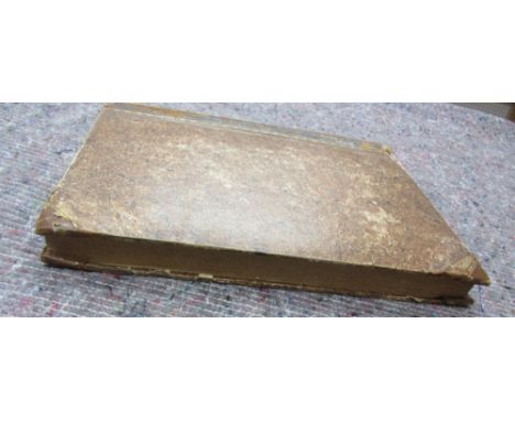
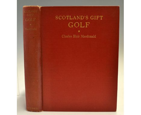
Macdonald, Charles Blair -"Scotland's Gift Golf - Reminiscences 1872-1927" 1st ed 1928 published Charles Scribner's Sons, NY in the original red and gilt cloth boards and spine (slight rubbing and shelf wear to top and tail of spine) c/w the original frontis tissue guards together with various other colour plates and photo lithographs and fold out map of the National Golf Links of America to the rear. Very clean internally c/w cellophane wrapper. Owners name hand written to front side board otherwise (VG) - scarce copy not seen very often on the open market
Lot 246
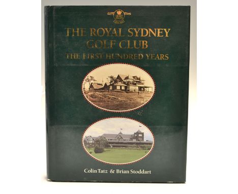
Tatz, Colin & Brian Stoddart "The Royal Sydney Golf Club-The 1st Hundred Years" 1st edition 1993 published by Allen and Unwin Pty Ltd Australia, some shelf wear to the bottom of the boards complete with the original dust jacket, 284p; illustrated endpapers, 29 colour plates, numerous half tone illustrations, 1 d/p. colour map, 18 sketch diagrams, 8 map illustrations, sketch illustrations, appendixes, index; dustjacket, fine copy (G) Note History of one of Australia's foremost social and sporting institutions and its relationship to Sydney


Lot 183
A Collection of Ten Framed Antique Hand Tinted Maps sold by Abel Swal, Aunsham & John Churchill: Eight by Robert Morden: 'The County Palatine of Lancaster' 16½ ins x 14 ins (42 cms x 35.5 cms), 'Westmorland', 14¼ ins x 16¼ ins (36 cm x 41 cms), 'Middlesex', 14½ ins x 17 ins (37 cm x 43 cms), 'The West Riding of Yorkshire', 14¼ ins x 16¼ ins (36 cm x 41 cms),'The East Riding of Yorkshire', 14 ins x 16¾ ins (35.5 cm x 42.5 cms), 'The North Riding of Yorkshire' 14¼ ins x 16½ ins (36 cm x 42 cms). 'Lincolnshire', 14¼ ins x 16½ ins (36 cm x 42 cms), and 'Comitatus Retelandiæ Tabula Nova & Aucta' 11¼ ins x 14¼ ins (28.5 cm x 36 cms). An Owen & Bowen strip road map of Malton to Whitby, circa 1730, 7¼ ins x 4¾ ins (18.5 cm x 12 cms). And 'Cambridgeshire' by Sutton Nicholls, 16¾ ins x 14 ins (42.5 cm x 35.5 cms).

Lot 184
A Set of Four Late 18th Century Engravings inscribed; ''A Set of Four FOX HUNTINGS' which are in the highest repute, from that elebrated artist J. Seymour; entitled; 'Going to Cover', 'Making a Cast at a Fault', 'The Chace of the Fox', and 'The Death of the Fox', Printed for Carrington-Bowles, at his Map & Print Warehouse, Number 69, in St Paul's Church Yard, London'. 15 ins x 20½ ins (38 cms x 52 cms).


Lot 1082
SUESS (Eduard): 'The Face of The Earth..' Oxford, Clarendon Press, 1904-1924. 5 vols, including the final map/index volume. Large 8vo, uniform red publishers cloth gilt, rubbed: DAMON (Robert): 'Geology of Weymouth, Portland, and coast of Dorsetshire..' Weymouth, 1884. New enlarged edition: 8vo, publishers cloth, damp marked: together with 7 others, natural history/geology/paleontology, various sizes. (13)

Lot 1093
LIVINGSTONE (David): 'Missionary Travels and Researches in South Africa..', London, John Murray, 1857. First Edition. 8vo, publishers blind stamped brown cloth gilt by Edmonds & Remnants, somewhat rubbed and marked but a good copy, retaining folding map in pocket at rear: together with 8 other volumes, African travel, including a 2 vol set of H M Stanley's 'In Darkest Africa' (fifth edition 1891, publishers cloth) and Lydekker's 'The Game Animals of Africa', London 1926. (9)

Lot 1100
WORLD MAP: 'Stanford's Library Map of the World on Mercator's Projection..' London, Edward Stanford, 1882. Colour litho map, printed on paper and dissected into 40 sections laid onto linen, approx 95 x 170cm unfolded, folding down into original black morocco slipcase gilt lettered to one side, case rubbed and scuffed, map a little browned and finger marked, but generally in good condition. (1)

-
109182 item(s)/page