

Gundappa (D. V.). All About Mysore, a comprehensive handbook, 1st edition, Bangalore: Karnataka Publishing House, 1931, 30 monochrome illustrations, folding map to the rear, advertisements to the front & rear endpapers, some very minor spotting, original white cloth, boards & spine lightly rubbed & marked, 8vo, together with:Barton (William), India's North-West Frontier, 1st edition, London: John Murray, 1939, 10 monochrome illustrations, 3 maps, some damp staining to the foot of the text block, some light toning & spotting, original black cloth, boards & spine slightly rubbed & marked, 8vo, plusYounghusband (G. J. & Frank E.), The Relief of Chitral, 1st edition, London: Macmillan and Co., 1895, 24 monochrome illustrations plus a folding map, ex-library copy with associated marks & stamps, front gutter cracked at the Preface, some toning & light spotting throughout, contemporary green cloth library binding, boards lightly rubbed, 8vo, and other late 19th & early 20th century India history & reference, mostly original cloth, some leather bindings, G, 8vo QTY: (6 shelves)
We found 109198 price guide item(s) matching your search
There are 109198 lots that match your search criteria. Subscribe now to get instant access to the full price guide service.
Click here to subscribe- List
- Grid
-
109198 item(s)/page

* Middlesex. Speed (John), Midle-Sex described with the most famous Cities of London and Westminster, George Humble [1611 - 27], engraved map with early hand-colouring, inset town plans of Westminster and London, inset views of Saint Peters and Saint Pauls, small split within the vignette of St. Pauls, slight staining, one repaired closed tear, 385 x 515 mm, mounted, framed and glazedQTY: (1)

Beuter (Pedro Antonio). Cronica generale d'Hispagna, et del Regno di Valenza. Nella quale si trattano gli avenimenti, & guerre, che dal Diluvio di Noe insino al tempo del Re Don Giaime d'Aragona, che acquistò Valenza in Spagna si seguitarono : insieme con l'origine delle Città, terre & luoghi piu notabili di quella, & di tutte le Nationi, & Popoli del Mondo : Opera veramente molto curiosa, & dilettevole. Composta dall' eccellente M. Anton Beuter, Maestro in sacra Theologia, & nuovamente tradotta in lingua Italiana dal S. Alfonso d'Ulloa, 1st edition in Italian, Venice: Appresso Gabriel Giolito de' Ferrari, 1556, [38 unnumbered leaves], 533pp. + single leaf at end, title with printer's woodcut device, woodcut initials, head-pieces, etc., double-page woodcut map of Spain (close-trimmed to lower edge, touching the outer printed borderline), register leaf to verso of final leaf of text, and additional leaf with large printer's woodcut device to verso (additionally inscribed in brown ink at foot 'Snr. frasisco Sanarone carcerato dali 9di 9bre 1639, nelle carceri do S. Jacopo per tutti li 15 8bre 1640.. et continua', 19th century bookseller's label of La Anticuaria Libreria de Llordachs hermanos, Plaza de Sn. Sebastian 5 (Arcos) Barcelona, and 19th century armorial ownership bookplate of the Biblioteca de D. Feliciano Ramirez de Arellano, Marques de la Fuensanta del Valle, to front pastedown, all edges gilt, 17th century Neapolitan gilt-decorated red full morocco, incorporating large coat of arms of Don Pedro de Aragon to each cover, lightly rubbed, 16moQTY: (1)NOTE:Provenance: Don Pedro de Aragon (1611-1690), Viceroy of Catalonia from 1642 to 1644, ambassador in Rome (1664–1666), and Viceroy of Naples (1666–1671), as well as Commander in chief of Catalonia. He was the brother of Cardinal Pascual de Aragón, Viceroy of Naples, 1664–1666. During his ten years in Italy (1662–1672), he amassed an extensive private library. As a protector and patron of Poblet Monastery, he donated his library of approximately 3600 volumes in 1677 in exchange for burial there after his death.Jesús Dominguez Bordona, The library of the Viceroy Don Pedro de Aragon (1611-1690), Archaeological Bulletin, Tarragona, IV, fascicle 2, 1948, pp. 71-106.
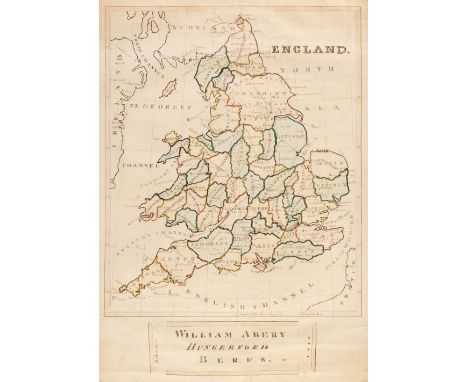
England & Wales. Abery (William), England, Hungerford, 'Midsummer' 1846, large manuscript map in ink and watercolour, slight spotting and staining, occasional marginal tape staining, one repaired closed tear affecting the title cartouche, 890 x 620 mmQTY: (1)NOTE:An unusually large manuscript map.
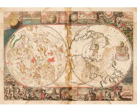
Moxon (Joseph or James). A collection of six Biblical Maps: Untitled double hemisphere map, one hemisphere being celestial, the other terrestrial, Paradise or the Garden of Eden with the Countries circumjacent Inhabited by the Patriarchs, Israels Perigrination. or the Forty Years Travels of the Children of Israel..., Canaan or the Land of Promise..., Travels of St. Paul and other the Apostles [and] Jerusalem, circa 1695, six double-page engraved maps with contemporary outline colouring, each map laid on near-contemporary card and bound 'back-to-back', heavily water stained, some maps split in half along the central fold, three with old sellotape staining scars to the central fold, each approximately 320 x 470 mm, later paper wrappers with late 19th-century ownership signature and title to upper cover, wrappers frayed and worn with crude tape repairs to the spine, overall size 445 x 285 mm, together with Munster (Sebastien). Designatio civitatis Badensis Helveticae, una cum oppidulo ther[marum], Basel [1554 or later], uncoloured woodblock plan of Baden, laid on later card, upper right corner torn with loss to title and image, crudely repaired, 280 x 345 mm, framed and glazed QTY: (2)NOTE:The first map described: R. W. Shirley. The Mapping of the World, number 549.

Maw (George). A MonographoftheGenusCrocus, 1st edition, London: Dulau and Co., 1886, half-title, double-page colour lithograph map, 81 hand-coloured lithograph plates (plate 17 was never published, faint blind stamp to plates), letterpress wood engraved vignette illustrations, toning and spotting mostly to first and last leaves, inscription to upper pastedown 'Presented to the Society by Mrs E. A. Walker, Spencer's Belle View, Bath, 1889', and with bookplates of the Bath Branch of the Selborne Society and Bath Public Reference Library, hinges repaired, top edge gilt, remainder untrimmed, original green cloth with bevelled edges to boards, rebacked preserving original spine (with library classification number in gilt), evidence of label adhesive at foot of upper board, some wear to extremities, large 4toQTY: (1)NOTE:Nissen 1316. Considered the finest work ever published on theGenusCrocus. GeorgeMaw was a polymath whose occupations included chemistry, geology, botany, archaeology, watercolour painting and gardening. He was a manufacturer of caustic and other tiles which were exported all over the world. Maw and Company also produced art pottery, employing well-known designers such as Walter Crane. Maw was an experienced plant hunter and accompanied Sir Joseph Dalton Hooker on a plant-hunting exhibition to Morocco and the Atlas Mountains in 1871. He became an expert on theCrocus and illustrated his monograph - the result of ten years toil - with his own watercolours, of which John Ruskin wrote that they were "most exquisite... and quite beyond criticism".
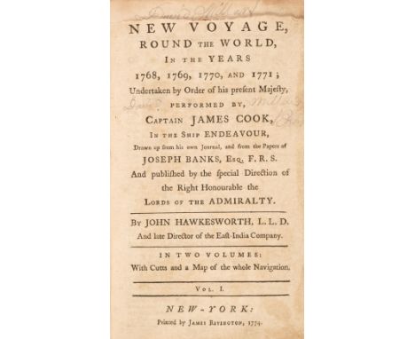
Hawkesworth (John). New Voyage, Round the World, in the Years 1768, 1769, 1770 and 1771; Undertaken by Order of his present Majesty, performed by Captain James Cook In the Ship Endeavour, volume 1 only (of 2), 1st American edition, New York: Printed by James Rivington, 1774, engraved frontispiece by Paul Revere, engraved map, portion of head of title excised (missing 'A' in title), both map and frontispiece torn with loss of around half the illustration, 19th-century ownership inscription 'John Anderson' to pastedowns, contemporary sheep, black morocco title label lettered in gilt, upper joint cracked, some wear to extremities, 8voQTY: (1)

Weller (Edward). Eighty Maps from The Weekly Dispatch Atlas, circa 1865, eighty (only) lithographic county and regional maps and town and city plans, all with contemporary outline colouring, map of France torn with slight loss, lacking boards, spine and preliminaries, overall size 480 x 340 mmQTY: (1)NOTE:Sold as a collection of maps, not subject to return.
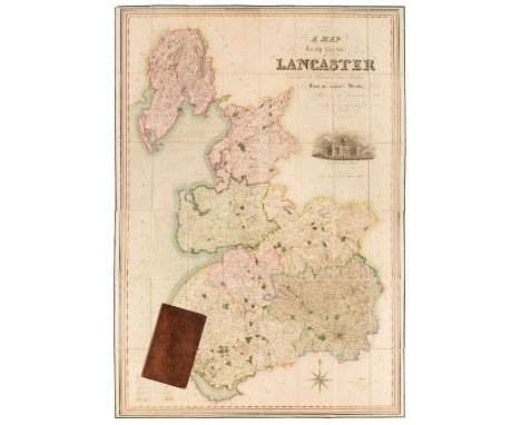
Lancashire. Hennet (G.), A Map of the County Palatine of Lancaster Divided into Hundreds and Parishes from an accurate survey made in the years 1828 and 1829, Henry Teesdale and Co. May 1st. 1830, large-scale map engraved by James Bingley, bright contemporary wash colouring, sectionalised and laid on linen, calligraphic cartouche, compass rose, table of explanation, uncoloured vignette of the New Custom House Liverpool, slight staining, edged with green silk, marbled endpapers, 1615 x 1130 mm, contained in a contemporary marbled calf book-box with contrasting morocco gilt label to spine, bumped with very slight wear to extremitiesQTY: (1)

Colnaghi & Co. (publishers). A Collection of Select Views in London and Westminster..., circa 1800, printed title, 15 uncoloured engraved plates only, each with a page of descriptive text, contemporary half morocco, heavily worn and frayed with printed label to the upper cover, 4to, together with Shepherd (Thomas H.). London and its Environs in the Nineteenth Century, Illustrated by a Series of Views..., Jones & Co. 1829, decorative title page, 187 uncoloured engraved views on 79 sheets, many with tissue guards, slight spotting throughout, contemporary half morocco gilt, rubbed and worn, 4to, with two other volumes similar, but partially excised and containing 222 (only) uncoloured engravings, one volume with hinges and joints cracked, contemporary half morocco gilt, rubbed and worn, the other lacking boards and spine, both 4to, plus Mead (J. publisher). London Interiors with their Costumes & Ceremonies..., 1841, additional decorative title, engraved frontispiece, 70 uncoloured engraved plates, all edges gilt, contemporary cloth gilt, spine partially lacking, rubbed and worn, 4to, plus Ritchie (L.). Windsor Castle and its Environs, Including Eton College, 2nd edition with additions, Henry G. Bohn, 1848, frontispiece of a young Queen Victoria, additional decorative half-title, engraved map of Windsor Park and 13 (complete) engraved plates, slight spotting and finger soiling throughout, contemporary calf, rebacked, heavily rubbed and worn, 8vo, together with Charles Knight (publisher). The Land We Live In, 3 volumes, circa 1850, numerous wood engravings throughout, publishers cloth gilt, boards faded and worn, 4to, with a collection of approximately 650 engravings of London after Thomas Shepherd, numerous duplicates and a collection of approximately 100 views of Oxford and Cambridge by J. Le Keux, each approximately 120 x 150 mm QTY: (approx. 750)NOTE:Sold as a collection of prints, not subject to return.
![China. Mercator (Gerard), China, [1606 - 1630], engraved map with contemporary outline colouring, insular Korea, large margin](https://cdn.globalauctionplatform.com/f76c836e-8902-455b-9c0b-b0c2011e8969/6819d2eb-1ad8-40b1-b82e-b0cb010bf146/468x382.jpg)
China. Mercator (Gerard), China, [1606 - 1630], engraved map with contemporary outline colouring, insular Korea, large margins, margins with slight toning, 345 x 465 mm, French text on versoQTY: (1)NOTE:A decorative and early map of China. The Great Wall is shown in the northwest of China, and to the left is a vignette illustration of a Chinese land yacht. The Bering Strait is annotated as the Strait of Anian, with a small section of the northwest American coast in the upper right corner. Two ships, one a Chinese junk and the other European patrol the Pacific Ocean. In an additional cartouche, there is a description and illustration of a Japanese crucifixion.

England & Wales. Walker (J. & C.), A Geological Map of England, Wales and part of Scotland, showing also the Inland Navigation with the Rail Roads and Principal Roads, published J. & C. Walker, March 15th 1838, engraved map with contemporary hand colouring, sectionalised and laid on linen, calligraphic title, table of explanation, two geological and mineralogical cross sections below the map, slight browning, 940 x 655 mm, later ink ownership signature on versoQTY: (1)
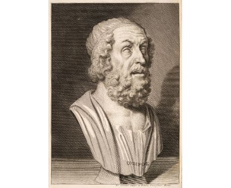
Pope (Alexander, translator). The Iliad of Homer, 6 volumes, 1st folio edition, London: Printed by W. Bowyer, for Bernard Lintott, 1715-20, engraved portrait frontispiece to first volume, list of subscribers, 5 engraved plates and maps (3 folding including folding map of Greece), without final blank in first volume, light worming to lower outer blank corners of initial half of leaves in volume 3, some toning and scattered spotting, armorial bookplate of Edward Francis Witts to upper pastedowns, contemporary mottled calf, each volume neatly rebacked preserving maroon morocco title labels, board corners worn, folioQTY: (6)NOTE:Rothschild 1573.
Walker (J. & C., publishers). Hobson's Fox-Hunting Atlas containing separate Maps of every County in England and the three Ridings of Yorkshire, J. and C. Walker, circa 1860, printed title with a near-contemporary dated ownership signature, 42 (complete) lithographic double-page maps with bright contemporary outline colouring, contemporary manuscript annotations to the verso of the 'Reference to the Hunts' and to the maps of Bedfordshire and Hertfordshire, map of Lincolnshire trimmed to the image and laid on later paper, map of Lancashire with some offsetting, slight spotting throughout, marbled endpapers, hinges and joints cracked and weak with the upper board near-detached, contemporary red half morocco gilt, spine worn, frayed and partially lacking, boards stained and faded, worn at extremities, folio, together with Church Commissioners (publishers). Third Report from His Majesty's Commissioners Appointed to Consider the State of the Established Church with Reference to Ecclesiastical Duties and Revenues, printed at The House of Commons, 20th May 1836, 25 (of 26, lacking Peterborough) double-page lithographic maps by S. Arrowsmith, contemporary wash colouring, slight worming, some water staining and offsetting throughout, publisher's printed wrappers, upright folio, with Early Days (publisher). January - December 1880, chromolithographic frontispiece, with four pictorial maps of Leicestershire, Lincolnshire, Derbyshire and Yorkshire, publisher's gilt cloth boards, 8vo, with another 33 folding maps, guide books and atlases, various sizes and conditionQTY: (36)NOTE:Sold as a collection of maps, not subject to return.
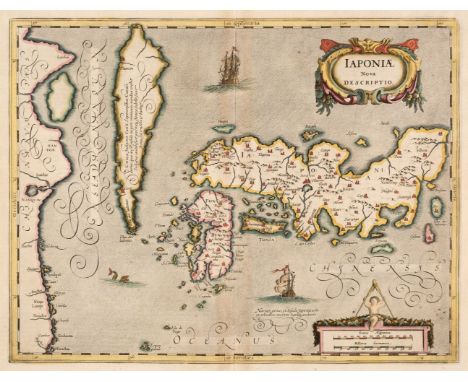
Japan. Mercator (Gerard, Hondius H. & Jansson Jan), Japoniae Nova Descriptio, Amsterdam, circa 1640, hand-coloured engraved map, insular Korea, decorative cartouche and mileage scale, large margins, very slight toning to the central fold, 345 x 455 mm, Latin text on versoQTY: (1)NOTE:A good example of one of the earliest European maps of Japan. Jansson has updated an early rendering of Japan by Mercator-Hondius, which in turn was taken from a separately published map of Japan by the sixteenth-century missionary Luís Teixeira.
Cary (C. & J.). Cary's Improved Map of England and Wales with a considerable Portion of Scotland, Planned upon a Scale of Two Statute Miles to one Inch, Drawn from the most Authentic Surveys and Parliamentary Documents, 1832, calligraphic double-page title, index map, and 65 (complete as keymap) engraved double-page map sheets, all with contemporary outline colouring, each sheet sectionalised and laid on linen, very slight spotting and very occasional contemporary ink marginalia to a few sheets, each sheet with marbled endpapers and a small publisher's title and miniature map to the upper cover, contained in 8 uniform half-calf book boxes, boxes worn and frayedQTY: (8)

Cary (John). Cary's New and Correct English Atlas: being a New Set of County Maps from Actual Surveys..., Jany. 1st. 1793, ownership signature to front endpaper, title page and contents list, 47 (complete as list) engraved maps with contemporary outline colouring, each map with a sheet of descriptive text, very occasional spotting, occasional pencil marginalia and annotations to the descriptive text, index bound at rear, bookplate of Edward Francis Witts, hinges and joints cracked, contemporary half calf, bumped and a little worn at extremities, some scaring to the boards, 4toQTY: (1)NOTE:Chubb. CCLXIII (but slight variant). Three of the maps have different publication dates. Leicestershire is dated 1792, Monmouth & Worcestershire, 1787.

Wytfliet (Cornelis). Four Maps of Japan, China, the Philippines and the East Indies: Chinae Regnum, Japaniae Regnum, Insulae Philippinae & India Orientalis, Douai, circa 1605, four uncoloured engraved maps, one small stain to the map of the Philippines, each approximately 100 x 125 mmQTY: (4)NOTE:Rare. Originally published in Histoire Universelle des Indes....,'.
Livingstone (David). A Popular Account of the Missionary Travels and Researches in South Africa, London: John Murray, 1861, engraved folding plate frontispiece, numerous engraved illustrations, folding map to the rear, some light spotting & toning throughout, re-backed original gilt decorated red cloth, spine & front board slightly faded, 8vo, together with:Stanley (Henry M.), In Darkest Africa..., 2 volumes, London: Sampson Low, et al, 1890, engraved illustrations, period inscriptions to the front endpapers, front & rear gutters of volume 1 cracked, some spotting, original uniform gilt decorated red cloth, boards & spines slightly rubbed & marked, 8vo, plusRichardson (Albert D.), Beyond the Mississippi: from the great river to the great ocean. Life and Adventure on the prairies, mountains, and Pacific coast..., Hartford: American Publishing Company, 1867, 205 monochrome illustrations, some minor loss to the front endpaper, some marginal toning & spotting throughout, original gilt decorated plum cloth, boards & spine rubbed & marked with some damp staining, 8vo, and The Mercury Press, publisher, Shanghai Dollar Directory, July 1934, Shanghai, numerous monochrome advertisements, some light toning, original yellow cloth spine to boards, slightly toned, marked & rubbed to the head & foot, 8vo, plus other late 19th early 20th century travel reference & related, including Africa, U.S.A., Europe, mostly original cloth, G/VG, 8vo/oblong 4toQTY: (6 shelves)

Maps. A collection of 33 British maps, 17th - 19th century, engraved maps, including 23 after Robert Morden, some maps wormed with loss, 6 framed and glazed, together with another nine maps including Porcacchi (Tomaso). Descrittione Dell' Isola D'Inghilterra, published Venice [1572 or later], hand-coloured engraved map, orientated to the west, Italian text below and on verso of map, map size 105 x 145 mm, mounted, with another eight maps, including examples by or after Van den Keere, Seller/Grose, Cary, Davies and Philippe, various sizes and condition, three framed and glazedQTY: (33)

Anson (George). A Voyage Round the World in the years MDCCXL, I, II, III, IV by George Anson, Esq., now Lord Anson, commander in chief of a squadron of His Majesty's ships, sent upon an expedition to the South-Seas. Compiled from his papers and materials by Richard Walter, M.A., chaplain of His Majesty's ship the Centurion in that expedition, 5th edition, London: Printed for the author by John and Paul Knapton, 1749, folding engraved world map facing title, 40 folding engraved plates and plans only (of 42, lacking the final two plates 41 and 42, chart of the Pacific Ocean, and Chinese vessels to face pages 385 and 414 respectively), engraved bookplate of Joseph Loscombe to front pastedown, contemporary full calf, rubbed and scuffed, thick 4toQTY: (1)NOTE:Sabin 1626; ESTC T74545; Borba de Moraes, p.38; Hill I, pp. 317-318.Official and highly popular account of Anson's four-year circumnavigation of the globe. In 1740 six ships and two merchant vessels with 1900 men, under the command of Commodore Anson, were sent to harass Spanish ships off the western coast of South America, and thus cut their supply routes from the Pacific Area. The voyage was fraught with sickness and deaths among the crew, attacks by Spanish ships, storms and mutinies, but nevertheless successfully captured a Spanish galleon off the coast of the Philippines which yielded an immense treasure of over 34 tons of silver. After a brief pause in Canton, Anson started his voyage back to England in December 1743, rounding the Cape of Good Hope in April, arriving in England in June 1744.

Milne (A.A.) Winnie-the-Pooh, 1st edition, London: Methuen & Co., 1926, illustrations by E.H. Shepard, map endpapers (free endpapers slightly toned), small stain upper outer corner (3mm) to pages 18-25, top edge gilt, original green cloth gilt, spine slightly darkened, otherwise a bright copy, 8voQTY: (1)
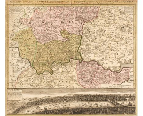
London. Homann (Johann Baptist, Heirs of), Regionis quae est circa Londinum specialis repraesentatio Geographica..., Ausfuhrliche Geographische Vorstellung der Gegend um London...., published Nuremberg, 1742, engraved map of the environs of London with contemporary hand-colouring, below the map is an uncoloured engraved panorama of the city, old adhesion scaring to the verso, left-hand vertical margin strengthened on verso, 510 x 575 mm, together with Russell (J.). London Extending from the Head of the Paddington Canal West to the West India Docks East..., J. Stratford, October 6th 1806, engraved map with contemporary outline colouring, table of reference below the map, old folds, some creasing and dust soiling, slight staining, long repaired closed tears, laid on later cotton, 320 x 555 mm, with Wallis (J.). Wallis's Plan of the Cities of London and Westminster, Jany. 16th. 1797, engraved map with contemporary outline colouring, sectionalised and laid on linen, dust-soiled and a little toned overall, small holes where old folds cross, short splits along old folds, 425 x 865 mm, plus Mogg (Edward). London in Miniature with the Surrounding Villages. Entire New Plan..., January 1st. 1827, engraved map with contemporary outline colouring, sectionalised and laid on linen, some staining, re-backed with later cotton, folds strengthened on verso, slight wear and loss to the printed image where old folds cross, later endpapers with facsimile title page and advertisement, 520 x 930 mm. and Bacon (G. W. publisher). Bacon's Map of Central London, circa 1900, folding colour lithographic map, laid on linen, 730 x 980 mm, bound with a 24-page index, publisher's decorative cloth boards, spine and part of upper cover faded QTY: (5)NOTE:The first described item. James Howgego. The Printed Maps of London, number 88. The second, number 240, is the first and only state. The third map, number 214, first state, and the fourth, number 237, state 16.
London Gazette. Bulletins of State Intelligence, &c., a broken run of 45 volumes, 1827-1877, all with modern endpapers, some minor toning, all bound with modern calf spines retaining contemporary half calf marbled boards, boards slightly rubbed, 8vo, together with:Wurtzburg (C. E.), The History of the 2/6th (Rifle) Battalion "The King's" (Liverpool Regiment) 1914-1919, 1st edition, Aldershot: Gale & Polden, 1920, monochrome illustrations & maps including rear pocket map, heavy oil damage to the front & rear pages, some toning throughout, original green cloth boards & spine slightly marked & rubbed, 8vo, plusMorse (Jedidiah), A Sermon, preached at Charlestown, November 29, 1798, on the anniversary thanksgiving in Massachusetts, facsimile edition, 1912, monochrome facsimile frontispiece, some minor spotting, original cloth spine to marbled boards, 8vo, and other military & miscellaneous reference, some leather bindings, some original cloth & some odd volumes, overall condition is generally fair/good, 8vo/folioQTY: (6 shelves)
![* Kauffer (Edward McKnight, 1890/91-1954). Air Mail Routes, [1935], colour lithographic poster incorporating a map of the wor](https://cdn.globalauctionplatform.com/f76c836e-8902-455b-9c0b-b0c2011e8969/3c8b073e-c995-4db7-9ab2-b0cb010c2c2c/468x382.jpg)
* Kauffer (Edward McKnight, 1890/91-1954). Air Mail Routes, [1935], colour lithographic poster incorporating a map of the world on a large black open hand against a sky background, showing the General Post Offices air mail routes, minor creasing and marks to extremities, small tear with blank loss to top margin near left corner, 73.5 x 91 cmQTY: (1)
![[Cary, John]. [New Map of England and Wales with Part of Scotland], circa 1794, title, dedication and preliminary leaves lack](https://cdn.globalauctionplatform.com/f76c836e-8902-455b-9c0b-b0c2011e8969/ad7a6e24-56f3-4ee2-af33-b0d201222f10/468x382.jpg)
[Cary, John]. [New Map of England and Wales with Part of Scotland], circa 1794, title, dedication and preliminary leaves lacking, hand-coloured engraved general map and bound with 56 hand-coloured engraved map sheets only (lacking sheets 4, 7, 8, 28, 37, 46, 53-55, 62-66, 70-76 & 78-81), modern half calf, 4to, together with Cary (John). Cary's New Itinerary, 2nd edition, with improvements, 1815, engraved title and dedication leaf, 7 folding engraved maps, occasional spotting, contemporary calf, rebacked, 8vo, Ogilvy (David). A General Itinerary of England and Wales, with part of Scotland, 1804, folding engraved map of England and Wales with contemporary hand-colouring in outline (repairs to verso), modern half calf, 8vo, Butler (Samuel). An Atlas of Ancient Geography, 1826, engraved title and 21 double-page engraved maps (20 with outline hand-colouring), light dust-soiling, sewing weak, contemporary red half morocco, worn, 8vo and 4 others QTY: (8)

Badeslade (Thomas). Chorographia Britanniae. Or, a new set of maps of all the counties in England and Wales, 2nd edition, London: C. Hitch and W. H. Toms, 1745, double-page engraved title and dedication, four engraved general maps of England and Wales, and 42 engraved maps (complete), seven engraved tables (all maps and tables double-page), few maps slightly torn to central folds, blank fore-margin of map of South Wales torn away (without loss to plate mark or printed area), endpapers renewed, contemporary calf, rebacked and corners repaired, maroon morocco title label to spine, 8vo QTY: (1)
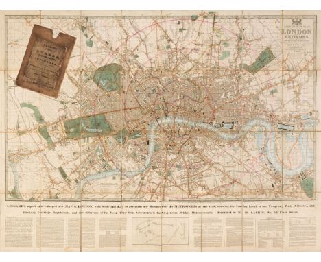
London. Laurie (Richard Holmes), Laurie's New Plan of London and its Environs with an Improved Scale for ascertaining Distances, The Fares of Hackney Coaches, Porterage of Parcels &c. by John Lingard..., being an original Survey by John Outhett, 1845, engraved map with contemporary outline colouring, sectionalised and laid on linen, key plan and explanatory text below the map, printed title pasted over old inscription, a few sections 'lifting', slight staining, a few short splits along linen folds, 820 x 1100 mm, contained in a contemporary slipcase with printed label to the upper cover, slipcase worn and rubbedQTY: (1)NOTE:James Howgego. The Printed Maps of London, number 361 state 6a
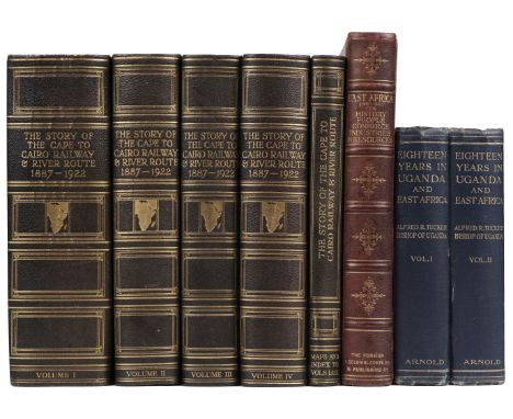
Weinthal (Leo, editor). The Story of the Cape to Cairo Railway and River Route, from 1887 to 1822, 5 volumes, 1st edition, London, The Pioneer Publishing Company Ltd, 1923-26, 12 loose folding maps contained in map and index volume, a further 5 folding maps contained in both volumes 3 and 4, colour illustrations and smaller maps throughout, including mounted portraits, original black half morocco gilt, 4to, together with:Playne (Somerset). East Africa (British). Its history, people, commerce, industries, and resources, 1st edition, London: Gresham Press, 1908-09, black and white illustrations after photographs throughout, maps, all edges gilt, original crushed maroon pictorial morocco gilt, spine faded, some rubbing to extremities, 4to, withTucker (Alfred). Eighteen Years in Uganda & East Africa, 2 volumes, 1st edition, London: Edward Arnold, 1908, frontispieces to each, folding map contained in rear pocked in volume one, black and white illustrations throughout, a few light spots, original blue cloth gilt, some light wear, 8voQTY: (8)

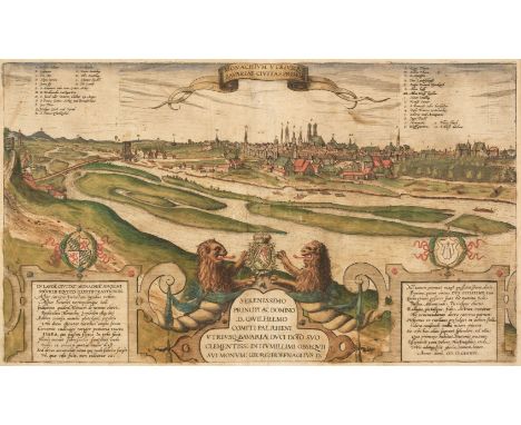
* Braun (Georg & Hogenberg Franz). Monachium Utriusque Bavariae Civitas Primar, circa 1580, engraved city plan of Munich, contemporary hand-colouring, slight creasing and staining, 285 x 485 mm, mounted, framed and glazed, together with Ortelius (Abraham). Silesiae Typus Descriptus et Editus a Martino Heilwig Neisense, et Nobili Viro Nicolao Rhedinger Dedicatus. Anno 1561 [1570 or later], engraved map with contemporary hand-colouring, 280 x 385 mm, mounted, framed and glazedQTY: (2)NOTE:The second described item. Marcel Van den Broecke, Ortelius Atlas Maps, number 102.

Dorset. Greenwood (C. & G.), Map of the County of Dorset, from an actual survey, made in the years 1825 & 1826..., published Sept. 11th 1826, large engraved map with contemporary wash colouring, calligraphic title, compass rose, table of explanation and a large uncoloured vignette view of Weymouth, slight overall toning, old drawing pin holes in each corner, the whole edged in green silk, marbled endpapers, 1170 x 1580 mm, contained in a contemporary calf book box, worn and rubbedQTY: (1)

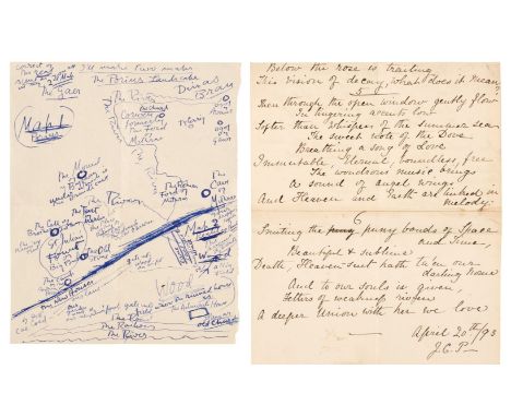
* Powys (John Cowper, 1872-1963). A collection of manuscripts, typescripts and photocopies plus manuscripts by other members of the Powys family, the John Cowper Powys manuscripts including '4 October 1896' [poem of 4 lines], 'Oh Mother Earth! Oh Father Air!', 2 pp., 'I'll Never Forget the Day' [poem written in childhood], 'To Father and Mother' [poem, 1897], 'The Storms of Time' [4 pp. poem], Poem of Nellie's Death, initialled and dated 20 April 1893, Map of the Landscape of Porius drawn by John Cowper Powys on the back of a part of a letter to Gertrude Mary Powys, fragments entitled 'Pengloy - Baban y Gawr' [3 damaged 4to pages]; various galley proofs including Race and Literature, Marcel Proust, Thomas Hardy and His Times, The Charms of Solitude, Children of Adam, etc.; plus a small quantity of other manuscript, printed and photocopied items relating to other members of the Powys family and 23 manuscript sermon booklets for sermons of Charles Francis Powys delivered at Montacute, etc., c. 1894-1914QTY: (2 box files & a packet)NOTE:Provenance: The Powys Collection at Mappowder, Dorset.

* Map Jigsaws. L'Amerique Meridionale, L'Amerique Septentrionale, L'Asie, and L'Afrique, Amsterdam: Covens & Mortier, between 1735 & 1778, a set of 4 (of 5) hand-coloured engraved wooden jigsaw puzzles (lacking the map of Europe), each with title vignette, each defective: L'Amerique Meridionale lacking one small piece (Tierra Del Fuego); L'Amerique Septentrionale lacking a few pieces (Canada and part of North America); L'Asie lacking several pieces (portion of Indochina, part of Indonesia and Malaysia, Persia, Turkey, Korea); and L'Afrique lacking several pieces (Black Sea, Ethiopia, Eastern Egypt, Persian Gulf), and with loss of paper engraving to 2 pieces (Sudan and portion of South Atlantic), L'Afrique toned, L'Asie with some toning and foxing, each map loosely held in original rimmed oak tray (broken and some pieces detached), 22 x 29.8 cm, housed in original oak box with wooden runners to accommodate each jigsaw (32.5 x 25 x 8.5 cm)QTY: (1)NOTE:An exceedingly rare and early boxed set of educational map jigsaw puzzles; we have not seen any other similar.Covens & Mortier was one of the largest and most successful publishing firms in Dutch history. Established by Pierre Mortier (1661-1711) in the late 17th century, the company passed to his son, Cornelius Mortier (1699-1783), and traded for almost two centuries, becoming particularly known for its maps, atlases and globes. In 1721 Cornelius married the sister of Johannes Covens (1697-1774), and his brother-in-law joined him in business. The firm of Mortier and Covens continued until 1778 when it was renamed J. Covens and Son, becoming Mortier, Covens and Son in 1794. As well as publishing their own maps, the firm also purchased plates from other companies. For example, on the death of Dutch publisher Pieter Van Den Aa (1659-1733), Covens and Mortier reissued his much admired Nouvel Atlas, from which these four maps were taken.John Spilsbury is commonly credited with creating the first dissected map around the mid 1760s, although this claim has been disputed (there are earlier references to dissected maps made by French educator and author Madame de Beaumont). Covens and Mortier first advertised that they were sellers of such jigsaws in 1779, but we know from the imprint that this set must date from at least the year before, and possibly earlier, bearing in mind that the firm were in possession of the plates as early as 1733. We can certainly say, therefore, that these are some of the earliest dissected maps, possibly even pre-dating Spilsbury and de Beaumont. Furthermore, in issuing a set of maps Covens & Mortier were tapping into a new market, and undoubtedly aiming at the most affluent, who were surely the only clientele who could afford such a luxury for their children.


Hughes (Griffith). The Natural History of Barbados. In Ten Books. By the Reverend Mr. Griffith Hughes, A. M. Rector of St. Lucy's Parish in the said Island, and F.R.S., 1st edition, London: Printed for the Author, 1750, title, dedication leaf, list of subscribers, folding engraved Map of the Island of Barbados, by Thomas Jefferys (plate size 43 x 36 cm), short closed tear without loss to right margin, 30 full-page engraved plates of mostly botanical and natural history subjects by James Mynde and George Bickham after Georg Dionysius Ehret and others, woodcut head- and tail-pieces, some spotting, mainly at front of volume and to margins, bookplate to front pastedown removed, contemporary calf-backed marbled boards, rubbed and joints partly cracked, folio (text block 36 x 23 cm) QTY: (1)NOTE:Nissen 950; Sabin 33582; Hunt 536; Great Flower Books p. 60.According to Hunt, this work 'is one to place beside Catesby's Natural History'. Hughes's Natural History of Barbados is the first book to describe a grapefruit calling it the Forbidden-Fruit-Tree.

Doyle (Arthur Conan). The Great Boer War, 1st edition, London: Smith, Elder & Co., 1900, 4 folding colour maps only (of 5, lacking map at p. 536), advertisements at rear, some light stains, hinges breaking, original cloth, closed tear and split to spine, some fading and small stains, 8voQTY: (1)NOTE:Inscribed by the author at front 'Yours most truly A. Conan Doyle. Nov 16th 1900'. Green and Gibson p. 245.

Russell (Bertrand). History of Western Philosophy, 1st edition, London: George Allen and Unwin, 1946, small neat contemporary ownership inscription to head of front free endpaper, original linen grey cloth, dust jacket (with map to verso), rear panel frayed with some loss at head, extremities lightly rubbed, 8voQTY: (1)

Kipling (Rudyard). Rudyard Kipling's Verse. Inclusive edition, 1885-1918, Garden City, New York: Doubleday, Page & Company, 1919, a little minor spotting, top edge gilt, original cloth gilt, spine a little faded and rubbed at ends, 8vo, inscribed to title 'Rudyard Kipling: Dec. 1919', together with A History of England, by C. R. L. Fletcher and Rudyard Kipling, 1st US edition, Garden City, New York: Double day, Page and Company, 1911, colour and monochrome illustrations, map endpapers, original cloth, spine slightly faded and rubbed at ends, 8vo, signed to title by Rudyard Kipling, plus 'They', 1st US edition, New York: Doubleday, Page and Company, 1906, colour illustrations by F. H. Townsend, some light spotting, top edge gilt, original cloth, upper cover with inset colour illustration, 8vo, inscribed to title 'Rudyard Kipling, Jan 2/32'QTY: (3)NOTE:From the library of A. P. Watt, Rudyard Kipling's literary agent.
* Williamson (Henry, 1895-1977). English novelist and journalist. A large archive of Henry Williamson’s papers and books, comprising: Dream of Fair Women, notes, typed and in manuscript, with a few single sheets of galley & page proofs, approx. 9 items; The Flax of Dream, typed and manuscript notes, 2 letters from Faber & Faber, signed Dick [probably Richard de la Mare], approx. 9 items; The Gold Falcon, one galley page, one typed, one manuscript; Goodbye West Country, typescript of a number of pages with annotations, a few proof pages, annotated, approx. 36 pp.; Tales of a Devon Village, 16 pp. page proofs, 2 of typescript, all with manuscript notes; The Golden Virgin, typescript (7 pp.) and layout dummy (7 pp. plus blanks) for preliminary pages; The Pathway, typescript of extra matter for p. 412 (old pagination), for new edition, 4 pages typescript with manuscript corrections, boards only of hardback edition with manuscript notes on rear endpaper and pencil map on rear pastedown; Devon Holiday, typed title-page and 4 pp. typescript with manuscript corrections; The Linhay on the Downs from Fortnightly Review, 8 pp. proofs with manuscript corrections; Lyon (Julia Hart, pseud. Ann [Myfanwy] Thomas), Women Must Love, [Faber, 1937], galley proof with manuscript corrections and numerous typed and manuscript corrections by the author and by Henry Williamson in his familiar hand and his often used red ink, lacks sheets 35(a) and 51(a), together with:a small collection of assorted Williamson literary manuscripts and typescripts; financial and literary estate papers including dealing with HMRC, capital gains tax, etc.; correspondence, calculations etc.; a large collection of photocopies made for the Henry Williamson estate from the original manuscripts of several of his books [the originals of these are presumed to be part of the University of Exeter deposits made in 1965 and 1981], plusa box of miscellaneous books from the library of Henry Williamson, a number with his ownership signature and/or owl monogram, including his dictionary and his thesaurusQTY: (3 cartons)NOTE:The corrections to the galley proof of the scarce novel Women Must Love may suggest this was a collaborative effort between Williamson and Thomas. Julia Hart Lyon was a pseudonym for Ann Myfanwy Thomas (1910-2005), daughter of the poet Edward Thomas, secretary and lover of Henry Williamson, with whom she had a child. This is her only novel; she later published a selection of memoirs, One of These Fine Days, 1982.
![Middlesex. Drayton (Michael). An untitled allegorical map of Middlesex and Hertfordshire [1612 or later], an uncoloured engra](https://cdn.globalauctionplatform.com/f76c836e-8902-455b-9c0b-b0c2011e8969/6e50e935-0579-49b6-9053-b0cb010c054e/468x382.jpg)
Middlesex. Drayton (Michael). An untitled allegorical map of Middlesex and Hertfordshire [1612 or later], an uncoloured engraved allegorical map, small vertical margins, 250 x 330 mm, together with Norden (John). Middlesex olima Trinobantibus Habitata, 1st edition, circa 1607, uncoloured engraved map, large strapwork cartouche, slight dust soiling, 275 x 340 mm, Latin text on verso, with Blaeu (Johannes). Middle-Sexia, Amsterdam, circa 1645, engraved map with contemporary outline colouring, 390 x 405 mm, Latin text on verso, framed and double-glazedQTY: (3)

Lewis (C. S.) The Voyage of the Dawn Treader, 1st edition, London: Geoffery Bles, 1952, illustrations by Pauline Baynes, map endpapers at front (faint offsetting from flap), original cloth, spine tips and extremities faded, dust jacket, spine illustration lightly toned, small tears and nicks at head, a few small closed tears to panel edges and folds, 8vo QTY: (1)

London. Homann (Johann Baptiste, heirs of), Urbium Londini et West-Monasterii nec non Surburbii Southwark Accurata Ichnographia..., Neuester Grundris der Staedte London und West-Munster, Samt der Vorstadt Southwark..., Nuremberg, circa 1736, large engraved map with contemporary hand-colouring, printed on three conjoined sheets, title cartouche in Latin and German, inset views of St Pauls, the Royal Exchange, St. James's Square and the Custom House, laid on later stiff paper, 515 x 1700 mmQTY: (1)
Salmon (Thomas). A New Geographical and Historical Grammar; Wherein the Geographical Part is truly Modern and the Present State of the several Kingdoms of the World..., William Johnson, 1754, additional half-title, dedication to George II, title printed in red and black, preface and 20 (only, lacking the map of the world and the Sphere) engraved folding maps by Thomas Jeffreys, two maps (Europe & Spain & Portugal) with naive later colouring, map of North America torn with slight loss to the upper right corner, skillfully repaired, hinges and joints cracked, upper board near detached, contemporary calf, rubbed and worn, 8vo, together with Heywood (John). John Heywood's County Atlas of England and Wales..., circa 1880, printed title, folding map of England and Wales and 42 uncoloured lithographic county maps, printed back-to-back, modern boards with old publisher's printed title and advertisement pasted to the front and rear boards, slim 8vo, with Law (James Thos. & Francis William F.). A New Set of Diocesan Maps. published by Lichfield Theological College, 1864, printed title and 27 double-page lithographic maps by W. J. Sackwell, each with explanatory text, slight offsetting and toning, later endpapers, publisher's boards with printed title to the upper siding, re-backed, folio, plus, George Philip & Son Ltd (publishers). Philips' Atlas of the British Isles..., circa 1920, 61 double-page colour lithographic maps, endpapers a little toned, publisher's cloth, faded and worn at extremities, folio, and, Philips' Introductory School Atlas, Philips' Elementary Atlas of Comparative Geography, Philips' Standard School Atlas [and] Philips' Progressive Atlas of Comparative Geography, all early 20th century, together four atlases containing numerous colour printed maps, mixed bindings, 4to, together with The Literary Press Ltd. (publishers). The Wonder Atlas, circa 1950, 24 colour printed maps, publisher's limp card pictorial boards, 4to, with a 'Barclays Dictionary' and a 'Guthrie's Geographical Historical and Commercial Grammar', but excised of all maps, plus, Dugdale (Thomas). Curiosities of England & Wales Delineated, 3 volumes, circa 1850, 9 (only double-page engraved maps and numerous engraved topographical views, manuscript presentation inscription to the front pastedown, contemporary calf gilt, worn and rubbed, 8voQTY: (14)NOTE:Sold as a collection of maps, not subject to return.

Cunard (Nancy, editor). Negro, Anthology made by Nancy Cunard, 1st edition, London: Wishart & Co, 1934, folding map entitled 'Ethnographical Map of Negro Africa', black and white illustrations after photographs throughout, two preliminary leaves loose and frayed, original publisher's brown cloth lettered in red, 'The Black Belt of America' map in red to lower cover, backstrip faded, 4toQTY: (1)NOTE:Provenance: From the library of Alan Clutton-Brock (1904-1976), thence by descent."It was necessary to make this book - and I think in this manner, an Anthology of some 150 voices of both races - for recording of the struggles and achievements, the persecutions and the revolts against them, of the Negro people" (Foreword).A landmark anthology, with contributors including Langston Hughes, Zora Neale Hurston, Samuel Beckett, Ezra Pound, William Carlos Williams and Theodore Dreiser. It is thought that 1000 copies were printed, however it has been asserted that many of these were destroyed during the Blitz when the warehouse was bombed.


Books. Buckland (Rev. Walter E). The History of Woodborough and of The Prebendal Church of Woodborough, published 1897, Dally (Richard) The Chichester Guide, published 1831, General View of The Agriculture of Hertfordshire, published by The Secretary of The Board of Agriculture London 1804, White (William) History, Gazetteer and Directory of Staffordshire, second edition, published 1851, Thompson (Pishey) The History and Antiquities of Boston, published 1856, England's Gazetteer or an Accurate Description of All The Cities, Towns and Villages of The Kingdom, vol II, published London 1751 and Kelly's Directory of Northamptonshire with new map, published 1894. (7)


British Commonwealth - Falkland Islands & Dependencies Collection with a Mint and Used range of Sets and Singles from 1891 - 1960 with much to interest. Falkland 1891 Mix of M/ U Vals noting SG33 - 6d Mint , 1898 ,2/6- & 5/- both vals Mint, 1904 3/- & 5/- both Mint , 1912-20 - 3/- & 5/- plus the 10/- SW Marginal all Mtd Mint , Then 1929- 1/- , 2/6- , and 10/- Mint 1933 with Mint Mtd Vals incl 2;6-, Silver Jubilee and RSW both Mint , 1938-50 Set plus some extra vals of note is the 5/- colour variant Mint , then Sets for 1952 b 1955 b and 1960 , Then FID 1946 Map Set , RSW , and 1954 seeing 2/- , 2/(- , and 10/- Values. A Highly Impressive Collection , with viewing highly recommended to appreciate.

COLLECTIONS & MISCELLANEOUS- Range of Albums Binders , folders , some purposed with a wide range mix throughout , with betternseen, GB - 1897 £1 SG 212 , Fine used bearing West Central District Pmk, but only of Spacefiller Quality , Small Qty of GB face seeing the £5 1977 HV in traffic light gutter mint , plus other odd to be found .Australia QEII animal set of 26 vals mint , Sarawak 1950 KGVI set looks like mix of M/U . Tanzania Butterfly set mint , Falkland Island 1946 Map set of 8 mint, Falkland Island 1952 set of 14 both mix of mint & Used, Falkland Island Dependence 1954-62 set of 15 mint .Turks & Caicos 1948 set of 7 used, St Helena Mix Vals of Badge of St Helena (7) land 1938 set to 2/6- mint , Nauru 1935 Silver Jubilee set mint, plus 1924-48 variety unchecked with vals to 2/6- , Hong Kong 1968 Sea Craft set mint, Grenada 1951 set mint, Cook Island 1949 set mint, Bermuda 1936 set 9 mint Small Range of 25th Anniv of Coronation sheets in phot Album , Bulging Centurion Album with wide range of Stamps , condition is mixed, ,Good range of 1963 Red Cross , and Freedom from a hunger in Album , Gibraltar one country Album with a sparse selection seen with 1925 2/- mint , 1931-33 The Rock of Gibraltar set mint , 1949 UPU Mint (2) sets, 1966 Churchill , plus 1966 World Cup and Sea Angling in blocks of 4 all mint , 1967 Shios set Mint , 1971 Decimal Currency mix pair Vals mint , Then various odds both mint and used up to 1974, Further GB Seeing Album page of Reds and Blues , Jersey with 1943-44 mint set plus further issues of back of book Isle of Man with loose in packets and on loose purposed Album pages, Japan with better seen , of note is 1948 Postal Service Exhibition Kanazawa and Takaoka mini sheet , 1949 Postal week mint . A good lot for sorting , Viewing Recommended
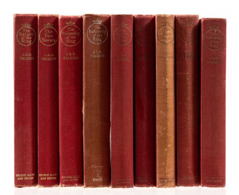
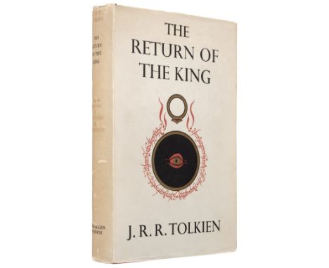
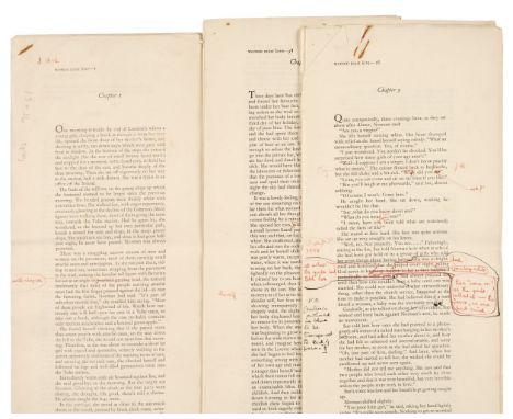
Tolkien (J.R.R.) The Lord of the Rings, 3 vol., comprising The Fellowship of the Ring, folding map at end, contemporary ink ownership inscription on front free endpaper, light soiling marks to cloth, 1954; The Two Towers, folding map at end, endpapers browned, spine sunned, light fading to upper panel, faint spots to panels, 1955; The Return of the King, lacking folding map, light spotting on endpapers, cloth soiled and spotted, 1955, first edition, second impressions, original cloth, spines dulled, ends and extremities bumped and creased; and 2 others sets of the same work, comprising third or fourth impressions, and a second edition set, all without jackets, 8vo (9)
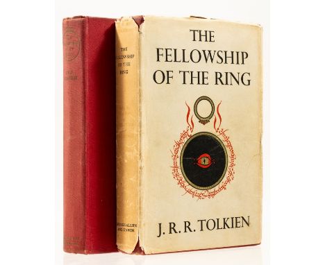
Tolkien (J.R.R.) The Fellowship of the Ring, second impression, folding map at end, light spotting to endpapers, original cloth, extremities bumped and lightly scuffed, dust-jacket, spine a little browned and scuffed, spine ends frayed with some light loss, extremities chipped, 1954; and another seventh impression copy of the same, without a jacket, 1957, 8vo (2)

SAYER (ROBERT) AND JOHN BENNETTThe Theatre of War in North America, with the Roads, and Tables of the Superficial Contents, Distances, &c, by an American, engraved map, hand-coloured in outline, with 3 columns of letterpress text below 'A Compendious Account of the British Colonies in North America', the map 42 x 52cm., overall 72 X 58cm., printed by Sayer & Bennett, Fleet Street, 1776This lot is subject to the following lot symbols: •• Zero rated for VAT, no VAT will be added to the Hammer Price or the Buyer's Premium.For further information on this lot please visit Bonhams.com
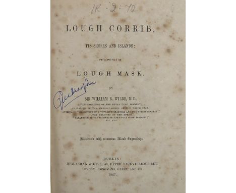
Galway interest: Wilde (Sir W.) Lough Corrib, its Shores and Islands, With Notices of Lough Mask. 8vo Dublin 1867, First Edn., Pres. Copy from Author, text illus. & fold. map, orig. cloth; [Otway (Caesar)] Tour in Connaught, sm. 8vo Dublin 1839. First Edn., text illus., a fold. map, lacks frontis cloth; Handbook to Galway, Connemara and the Irish Highlands, Lond. 1854. Fold. map, & profusely illustrated, cloth; de Bhaldraithe (Tomas) The Irish of Cois Fhairrge, Co. Galway, Dub. 1944. First Edn. Signed Presentation Copy. Good. (4)


-
109198 item(s)/page