We found 109198 price guide item(s) matching your search
There are 109198 lots that match your search criteria. Subscribe now to get instant access to the full price guide service.
Click here to subscribe- List
- Grid
-
109198 item(s)/page


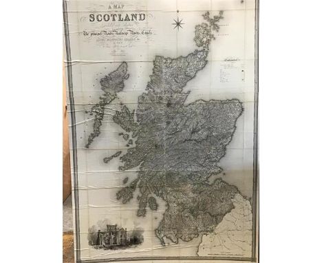
Lot 568
Kip after Badslade & Harris, an engraving of Penshurst from the History of Kent and three framed maps, including 'Gallia' after Jodocus Hondius, 'Plan de la Ville Citte et Universite et Fauxbourgs de Paris', with three pictorial borders of French monarchs and a small map of Kent after Kitchin


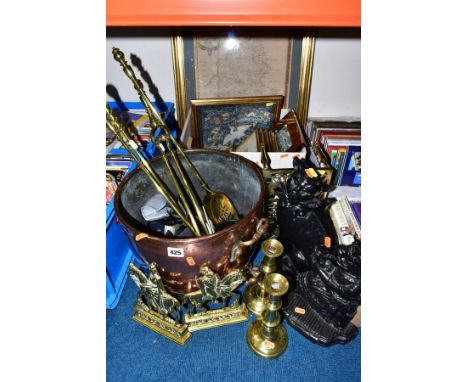
Lot 425
A QUANTITY OF BRASS, COPPER, TWO CAST IRON DOOR STOPS, AND A BOX OF LE BLOND PRINTS,ETC, including a pair of brass fireside ornaments of King Edward VII and Queen Alexandra, a black painted Mrs Punch door stop, another of cat form, a copper log bucket, Minolta camera, a framed and glazed map of Staffordshire, a Chinese embroidered silk panel, etc

Lot 87
A SELECTION OF MAINLY COSTUME JEWELLERY, to include a white metal ring, set with a pear cut pink paste, ring stamped 925, ring size L 1/2, an openwork Celtic band, stamped 925, ring size K 1/2 beaded necklaces, earrings, bracelets, bangles etc, together with a white metal open work embellished heart shape trinket, a yellow metal circular compact with a map of Ireland to the front etc

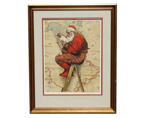
Lot 63
Norman Rockwell (1894-1978) "Extra Good Boys and Girls (Santa on Ladder with Map)" Pencil signed lower right, numbered (30/200) lower left. After the original image for the 1939 Cover of The Saturday Evening Post, December 16, 1939.Image Size: 25.75 x 20 in. Overall Framed Size: 39.25 x 31.75 in. Framed behind glass.
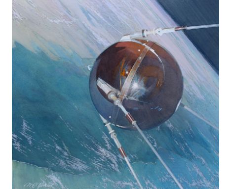
Lot 295
Mark Schuler (American, B. 1951) "First Man-Made Satellite 1957" Signed lower left. Original Mixed Media painting on Illustration Board. Provenance: Collection of James A. Helzer (1946-2008), Founder of Unicover Corporation. This artwork was originally published on the Republic of the Marshall Islands 45c First Man-Made Satellite stamp issued November 24, 1989. By the early 1950s, rockets were widely employed in studying the upper atmosphere. Scientists realized, however, that artificial satellites could perform the same duties much more efficiently. On July 29, 1955, President Eisenhower announced that the United States planned to launch "small unmanned earth-circling satellites." On October 4, 1957, the Soviet Union became the world's first nation to successfully launch an artificial satellite --Sputnik 1. On January 31, 1958, the U.S. launched Explorer 1, the first American space satellite. Explorer 1 discovered Earth was surrounded by ionized particles of energy. On March 17, 1958, the U.S. orbited Vanguard I, which demonstrated that Earth is almost imperceptibly pear-shaped with a slight bulge in the Southern Hemisphere. On October 1, 1958, the U.S. established the National Aeronautics and Space Administration (NASA) to manage the country's fledgling space program. On February 17, 1959, NASA launched Vanguard II, which was designed to provide information about Earth's cloud cover. Vanguard III followed several months later and was used to map Earth's magnetic field. The birth of the Space Age provided mankind with new insights into the mysterious universe and our place in it. Image Size: 12 x 12 in. Overall Size: 20 x 20 in. Unframed. (B12235)


Lot 73
Levasseur map of the Department de La Hautes-Garonne, France (Buzet Wine Region). This is a fascinating 1852 map of the French department of Haute-Garonne, France. This area of France produces the delicious but lesser known Buzet wines, and tender Rocamadour cheeses. The whole is surrounded by elaborate decorative engravings designed to illustrate both the natural beauty and trade richness of the land. There is a short textual history of the regions depicted on both the left and right sides of the map. Published by V. Levasseur in the 1852 edition of his Atlas National de la France Illustrée.Sight: 17 3/4 x 12 3/4 in. Overall: 22 1/2 x 17 in. Please note that all sales are final. No refunds will be given under any circumstances.

Lot 833
"Troupeau, Paissant, Sous Bois" (Herd Grazing in Undergrowth), oil on canvas, signed lower right. Charles Jacque was among the first generation of painters to leave the city for the forest of Fontainebleau, where he helped to establish the Barbizon School. Also a founding and influential member of the "Men of 1830", a loose movement of artists who, spurred on by the Revolution of 1830, sought out new directions in landscape painting. His strong, realistic, yet sensitive depictions of shepherds and their flocks form one of the most cohesive and important bodies of work produced by the movement.Born in Paris, Jacque began his training in etching rather than painting, as an apprentice to a map engraver. In this area, Jacque was unsurpassed among his colleagues in the Barbizon school. After military service, he went to England, where he worked as an engraver for La Charivari. Returning to France after two years abroad, he made his Salon debut in 1833 and regularly contributed paintings every year until 1870. Winning medals for both etching and painting, he was awarded the Legion d'honneur in 1867.During the 1840s, he and his friend, Jean-Francois Millet moved to the village of Barbizon where they felt they could more realistically portray nature. Jacque bought a house there and, influenced by Diaz's technique and Millet's themes, found his inspiration in hen-houses, pigsties and flocks of sheep at pasture. Jacque left Barbizon in 1854 and continued to paint in the outskirts of Paris until his death.Overall size: 39 x 35 in. Sight size: 24 1/2 x 20 1/2 in. Please note that all sales are final. No refunds will be given under any circumstances.
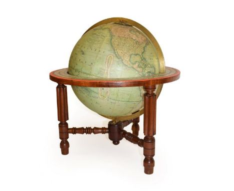
Lot 156
A Crutchley's 12'' Terrestrial Globe, circa 1865, with covered engraved gores, calibrated brass meridian and horizon ring, with Zodiac signs and calendar, on three melon fluted legs tied by turned stretchers, on peg feet, inscribed CRUTCHLEY'S NEW TERRESTRIAL GLOBE From the most recent authorities EXHIBITING THE LATEST DISCOVERIES IN CENTRAL AFRICA And the new SETTLEMENTS & Divisions of AUSTRALIA, NEW ZEALAND, CALIFORNIA, TEXAS & SEA G F CRUTCHLEY MAP SELLER, GLOBE MAKER & PUBLISHER 81 FLEET STREET Natural Scale 1: 41, 817, 600_666m21in 1865, 48cm high See illustration. In restored condition. Some visible splits but unable to warrant how much restoration has taken place.


Lot 395
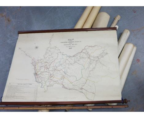
Ten Framed and Glazed Maps including ' The Road from the City of Salisbury com. Wilts to Campden com. Glouces' by Thos. Gardner .... humbly inscribed to the Honourable Sir William Humphreys ', 17cms x 27cms, County Map of Oxfordshire engraved for Dugdales plus other City and Country Maps including Sheffield, Gloucestershire, Oxfordshire, Berkashire, Yorkshire, Cheshire, etc

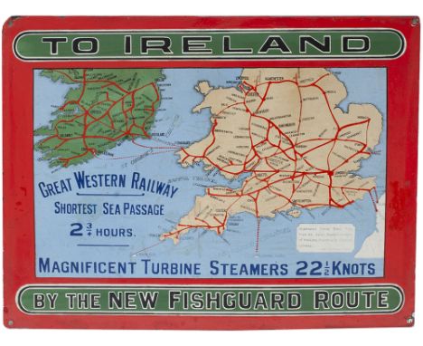
Lot 327
GWR Pictorial Enamel Map TO IRELAND BY THE NEW FISHGUARD ROUTE GREAT WESTERN RAILWAY SHORTEST SEA PASSAGE MAGNIFICENT TURBINE STEAMERS 22 1/2 KNOTS signed James Inglis General Manager. This is the extremely rare, small version measuring approximately 15in x 11.25in. In very good condition with a some small areas of restoration.


![HOPPIN, Benjamin (1851-1923). A Diary kept while with the Peary Arctic Expedition of 1896. [New Haven?: n.p., 1897].8vo. Map](https://cdn.globalauctionplatform.com/271baa46-60fe-44d2-9e85-ac5901551c26/f75739c8-60a4-45f2-9b43-ac5a00291910/468x382.jpg)
Lot 111
HOPPIN, Benjamin (1851-1923). A Diary kept while with the Peary Arctic Expedition of 1896. [New Haven?: n.p., 1897].8vo. Map frontispiece, one plate. Publisher's blue cloth gilt. Provenance: Edward T. Owen (presentation inscription dated 29 June 1897).FIRST EDITION, PRESENTATION COPY, INSCRIBED BY HOPPIN: "For Prof. Edward T. Owen '72 from B. Hoppin '72 Baddock, Cape Breton, Nova Scotia. For June 29th 1897." Hoppin, Peary's mineralogist, provides a first-hand account of the voyage of the Hope. RARE. Arctic Bib. 7401.For condition inquiries please contact Gretchen Hause at gretchenhause@hindmanauctions.com
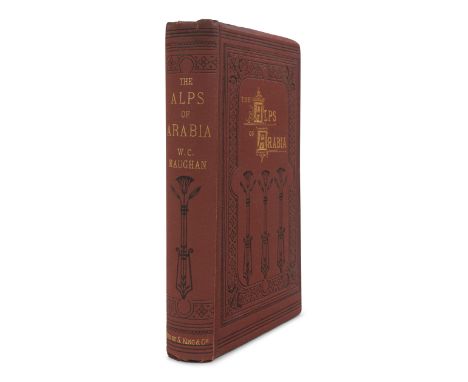
Lot 151
MAUGHAN, William Charles (1836-1914). The Alps of Arabia. Travels in Egypt, Sinai, Arabia and the Holy Land. London: Henry S. King & Co., 1873. 8vo (218 x 140 mm). Half-title, frontispiece map (library stamp affecting image), 36pp. publisher 's advertisements at end. Publisher 's decorated red cloth gilt (hinges starting, binding loose). Provenance: Clinton Hall Association, N.Y. For the Use of the Mercantile Library (library stamps). FIRST EDITION of Maughan 's narrative account of his travels through the Middle East.For condition inquiries please contact Gretchen Hause at gretchenhause@hindmanauctions.com
![[18th & 19th CENTURY PRINTING - ITALY]. A group of 4 works, comprising: OVID (43 BC-17? AD). Opera omnia. Amsterdam](https://cdn.globalauctionplatform.com/271baa46-60fe-44d2-9e85-ac5901551c26/28a63417-1b2c-4550-bb46-ac5a002f79c0/468x382.jpg)
Lot 191
[18th & 19th CENTURY PRINTING - ITALY]. A group of 4 works, comprising: OVID (43 BC-17? AD). Opera omnia. Amsterdam: Waesbergios, Boom & Goethals, 1702. 3 volumes, 8vo. Engraved frontispiece in vol. I, engraved title-pages. Contemporary vellum. -- CASTIGLIONE, Baldassarre. Opere volgari, e latine. Padova: Giuseppe Comino, 1733. 4to. Engraved portrait frontispiece, engraved vignettes. Contemporary vellum. Provenance: Conte Leonardo Vitetti (armorial bookplate). -- [BIBLE, in Greek]. Novum Testamentum, cum Verisione Latina. John Leusden, editor. Lyon and London: Wetstenios and John Nourse, 1772. 8vo. Engraved title, engraved folding map. Contemporary vellum. Provenance: George H. Culshaw (bookplate). -- ROSCOE, William (1753-1831). The Life and Pontificate of Leo the Tenth. Liverpool: J. McCreery for T. Cadell and W. Davies, 1805. 4 volumes, 4to. Engraved frontispieces. Modern half calf antique. FIRST EDITION. -- Together 4 works in 9 volumes, condition generally good. Property from the Collection of Edward A. QuattrocchiFor condition inquiries please contact Gretchen Hause at gretchenhause@hindmanauctions.com
![[CHICAGO]. NORRIS, J. Wellington. A Business Advertiser and General Directory of the City of Chicago, for the Year 1845](https://cdn.globalauctionplatform.com/271baa46-60fe-44d2-9e85-ac5901551c26/ed9d1e08-6bf2-443f-8a28-ac5a00305ef7/468x382.jpg)
Lot 203
[CHICAGO]. NORRIS, J. Wellington. A Business Advertiser and General Directory of the City of Chicago, for the Year 1845-6, together with a Historical and Statistical Account. Second year of publication. Chicago: J. Campbell & Co. Publishers, 1845. 8vo (195 x 115 mm). Steel engraved frontispiece (torn along fold, lacking half), steel engraved map, steel engraved illustrations of buildings; numerous advertisements printed within borders and occasionally illustrated. Addenda and errata leaf and 10 pp. advertisements, some on colored paper, at end. (Some spotting, heavier to the first few leaves, some browning. Original printed wrappers (frayed, a few tears occasionally affecting text, old tape repair front wrapper verso). A SCARCE PRE-FIRE CHICAGO IMPRINTSecond edition, with a map of Chicago in 1812, and illustrations of the First Universalist Church (Washington Street, between Clarke & Dearborn), First Methodist Church (corner of Clarke and Washington), Tabernacle Church (Lasalle St. opposite the public square), Catholic Church (corner of Wabash and Madison), Unitarian Church (Washington St. between Clarke and Dearborn), First Baptist Church (corner of Washington and LaSalle), Rush Medical College (Dearborn Street), St. James Church (Cass Street between Michigan and Illinois), and Lake House. Lacking a portion of the frontispiece, "City of Chicago,---South-West View, 1845," believed by McMurtrie to be among the earliest views of Chicago. EXCEEDINGLY RARE: According to online records, no copy of this rare pre-fire Chicago imprint has sold at auction since the Streeter sale, 1967. Rare Book Hub traces only two copies ever sold at auction. Graff 3029; Howes N-183; McMurtrie First Printers of Chicago p. 33; Sabin 12639; Streeter sale 1483.Property of a Midwestern InstitutionFor condition inquiries please contact Gretchen Hause at gretchenhause@hindmanauctions.com
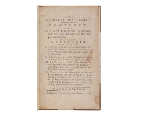
Lot 223
FILSON, John (ca 1747-1788). The Discovery, Settlement and present State of Kentucke: and An Essay towards the Topography, and Natural History of that important Country: To which is added...The Adventures of Col. Daniel Boon, one of the first Settlers, comprehending every important Occurrence in the political History of that Province... Wilmington, Del.: James Adams, 1784.8vo in 4s (196 x 194 mm). Without the map, as usual. (Small tissue repair to gutter margin title page recto crossing a few letters but not affecting legibility, without final blank leaf P4, some browning or spotting throughout.) Modern calf. FIRST EDITION OF THE FIRST BOOK ON KENTUCKY, AND THE FIRST BIOGRAPHY OF DANIEL BOONE. John Filson, one of the founders of Cincinnati, acquired 13,000 acres in Lexington, Kentucky, where he worked as a teacher and surveyor. Daniel Boone himself (along with Levi Todd and James Harrod) vouch for the authenticity of Filson's text: "at the request of the author of this book, and map, [we] have carefully revised them, and recommend them to the public, as exceedingly good performances, containing as accurate a description of our country as we think can possibly be given." Filson's text occupies 41 pages, followed by three appendices, the first of which is "The Adventures of Col. Daniel Boon," dictated by Boone. Filson refines Boone's diction, but the resulting narrative stands as a classic account of the settlement and exploration of the frontier. Boone concludes that "This account of my adventures will inform the reader of the most remarkable events of this country." Included here are also descriptions of the discoveries of mammoth bones and burial sites are also recounted, as are descriptions of Indian customs and manners. Tenoor Rook's map, mentioned on the title-page, was printed separately in Philadelphia and is virtually never found with the text. According to American Book Prices Current, no copy of the book with the map has been sold at auction since the Robert Hoe copy was sold as part of the stock of George D. Smith in 1921. Church 1202; Clark Old South II:23; Evans 18467; Field 536; Graff 1323; Howes F-129 ("d"); Jillson Kentucky 2; Sabin 24336; Streeter Sale III:1621.Property from the Estate of Mary Patricia Reynolds, Bowling Green, KentuckyFor condition inquiries please contact Gretchen Hause at gretchenhause@hindmanauctions.com
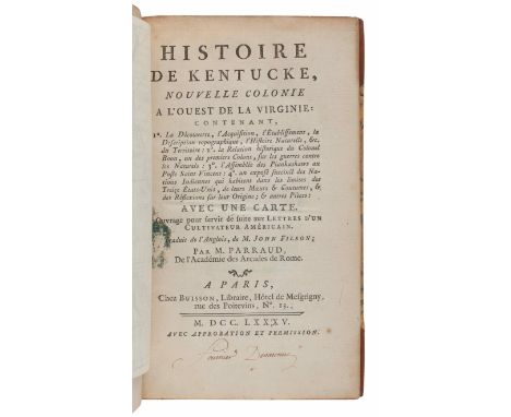
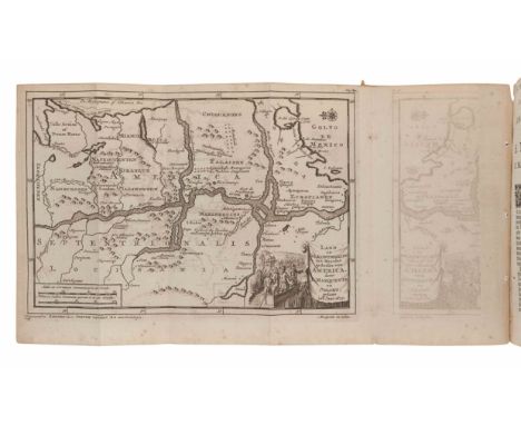
Lot 224
FILSON, John (ca 1747-1788). Histoire de Kentucke, Nouvelle Colonie a l'oueste de la Virginie. Paris: Chez Buisson, 1785. 8vo (202 x 120 mm). Half-title, facsimile fold-out map. (Lacking map, supplied in facsimile, small stain on title page, occasional spotting.) 19th-century quarter calf gilt with marbled boards, spine in 6 compartments with 5 raised bands, 2 gilt-lettered, the rest gilt-decorated, edges dyed red. FIRST EDITION IN FRENCH. Howes F-129; Sabin 24338. [With:] [KENTUCKY]. M'MURTRIE, Henry (1793-1865). Louisville and Its Environs. Louisville: S. Penn, 1819. 8vo. (212 x 127 mm). Folding map and table. (Splits at creases of map, title and preliminary pages loose, spotting throughout.) 20th century tan calf (spine and front board sunned). FIRST EDITION. Provenance: Alden Spooner (1783-1848), Brooklyn publisher of The Long Island Star (presentation slip); Brooklyn Apprentices' Library, later renamed the Youths Free Library, Brooklyn Institute (stamps, presentation slip); Long Island Historical Society (stamps, 1863 presentation slip). Howes M-174. Property from the Estate of Mary Patricia Reynolds, Bowling Green, KentuckyFor condition inquiries please contact Gretchen Hause at gretchenhause@hindmanauctions.com

Lot 225
FILSON, John (ca 1747-1788). A Map of Kentucky Drawn From Actual Observations. London: John Stockdale, 1793. Engraved map with hand-coloring in outline, sheet 509 x 468 mm. Inset map "A Plan of the Rapids in the River Ohio," compass rose. (All edges tipped to backing board, separation with small loss along center fold, 3 1/2-in. tear crossing border and image, some minor spotting.)Based on Filson's map of 1784, this edition, published 23 November 23 1793, appeared in Stockdale's edition of Filson's The Discovery, Settlement and Present State of Kentucky (1793) and two different 1794 editions of Jedidiah Morse's The American Geography; Or, A View of the Present Situation of the United States of America. Despite numerous smaller-format versions of Filson's 1784 map, the 1792 Stockdale edition is the only other full-sized edition of the map, and is the only obtainable full-sized edition of Filson's map. Filson created the map to be included with his The Discovery, Settlement and Present State of Kentucke (see previous lot), though the map is rarely found with copies of the work. Property from the Estate of Mary Patricia Reynolds, Bowling Green, KentuckyFor condition inquiries please contact Gretchen Hause at gretchenhause@hindmanauctions.com
![[ILLINOIS -- MAP]. Illinois. Philadelphia: Anthony Finley, 1833. Engraved map of Illinois with hand-coloring, 480 x 332](https://cdn.globalauctionplatform.com/271baa46-60fe-44d2-9e85-ac5901551c26/bc43c238-d05e-434f-a77e-ac5a00324847/468x382.jpg)
Lot 231
[ILLINOIS -- MAP]. Illinois. Philadelphia: Anthony Finley, 1833. Engraved map of Illinois with hand-coloring, 480 x 332 mm, matted and framed, unexamined out of frame. Depicting Michigan at Illinois' northern border, and the Missouri Territory along the western border. With an inset map of the lead mine region east of the Mississippi River. For condition inquiries please contact Gretchen Hause at gretchenhause@hindmanauctions.com
![[ILLINOIS -- MAPS]. A group of 4 maps, comprising: BURR, David. Map of Illinois with parts of Indiana, Ouisconsin, &](https://cdn.globalauctionplatform.com/271baa46-60fe-44d2-9e85-ac5901551c26/c0d36e11-044b-4711-a44c-ac5a00325072/468x382.jpg)
Lot 232
[ILLINOIS -- MAPS]. A group of 4 maps, comprising: BURR, David. Map of Illinois with parts of Indiana, Ouisconsin, &c. N.p., 1836. Engraved map. -- BRADFORD, T.G. Illinois. Boston, 1838. Engraved map with hand coloring. -- Thompson Brothers & Burr. Map of Naperville, DuPage County, Illinois. N.p., 1874. Engraved map with hand coloring. -- Naperville: Lisle & Naperville Townships. N.p., n.d. Engraved map with hand coloring. For condition inquiries please contact Gretchen Hause at gretchenhause@hindmanauctions.com

Lot 233
IMLAY, Gilbert (ca 1754-1828). A Topographical Description of the Western Territory of North America. London: J. Debrett, 1793. 8vo (204 x 125 mm). Half-titles. Folding frontispiece map, 2 additional folding maps, and 1 folding table of distances. 20th-century calf, gilt.Second edition of Imlay's account of western expansion; expanded by the addition of John Filson's The Discovery, Settlement, and Present State of Kentucky (see lot 289), continually paginated comprising pp.269-415. With the author's name on the title-page erroneously listed as "George" instead of Gilbert. Bradford 2572; ESTC T51472; Howes I-12; Sabin 34355Property from the Estate of Mary Patricia Reynolds, Bowling Green, KentuckyFor condition inquiries please contact Gretchen Hause at gretchenhause@hindmanauctions.com
![[JEFFERYS, Thomas]. La Peninsule et Golfe de la Floride ou Canale de Bahama avec les Isles de Bahama. Paris: Le Rouge, 1777.](https://cdn.globalauctionplatform.com/271baa46-60fe-44d2-9e85-ac5901551c26/e03adcb4-6ec1-4df1-a5e5-ac5a003285c2/468x382.jpg)
Lot 234
[JEFFERYS, Thomas]. La Peninsule et Golfe de la Floride ou Canale de Bahama avec les Isles de Bahama. Paris: Le Rouge, 1777. Engraved map of Florida with hand coloring, visible area 482 x 705 mm, matted and framed, unexamined out of frame. (A few tiny holes, some light dampstaining.) French edition of Jefferys' map of Florida, comprising one sheet of a larger two-sheet map depicting Florida and the Gulf region (without Carte De La Floride Occidentale et Louisiane, which details the Gulf region and the Florida Panhandle). The map was produced to be included in Le Rouge's Pilote Americain Septentrionale, printed for the use of the French Navy during the American Revolution, which drew on the North American Pilot (1775). For condition inquiries please contact Gretchen Hause at gretchenhause@hindmanauctions.com
![[MAMMOTH CAVE]. A group of 3 works about Mammoth Cave, comprising: [CROGHAN, John]. Rambles in the Mammoth Cave, During](https://cdn.globalauctionplatform.com/271baa46-60fe-44d2-9e85-ac5901551c26/71679248-2c1c-42af-88e5-ac5a00336ce9/468x382.jpg)
Lot 247
[MAMMOTH CAVE]. A group of 3 works about Mammoth Cave, comprising: [CROGHAN, John]. Rambles in the Mammoth Cave, During the Year 1844. Louisville: Morton & Griswold, 1845. Fold-out "Map of the Explored Parts of the Mammoth Cave of KY." Modern leather. Howes C-905; Jillson, Rare Kentucky Books, p.108; Sabin 17590. -- RANDOLPH, Helen. F. Mammoth Cave and the Cave Region of Kentucky. Louisville: Standard Printing Company, 1924. Folding map, illustrations, and advertisements including a full-page ad for "the New Brown Hotel / The South's Most Modern Hotel" which had just opened in 1923. Original publisher's blue cloth gilt. -- LOGAN, John A. Echoes from the Hills of the Mammoth Cave Country. Bowling Green, KY: Porter-Coombs Printing Company, 1930. Original publishers red cloth. -- Together, 3 works in 3 volumes, all FIRST EDITIONS, 12mo and 8vo, conditional generally very good. Property from the Estate of Mary Patricia Reynolds, Bowling Green, KentuckyFor condition inquiries please contact Gretchen Hause at gretchenhause@hindmanauctions.com
Lot 248
MARQUETTE, Jacques (1637-1675). Ontdekking Van eenige Landen en Volkeren, in 't Noorder-gedeelte Van America. Door P. Marquette en Joliet. Gedaan in het Jaar 167. Leiden: Pieter Vander Aa, 1707. 8vo (178 x 112 mm). Engraved title page vignette by J. Goeree, engraved folding map "Land en Volk-ontdekking in 't Noorder ge deelte van America, door P. Marquette en Joliet"; 2 folding engraved plates. (Small wormtrack to gutter margins, stab holes from old binding in gutter margin, minor chipping with loss to lower corner of title-page). 19th-century wrappers, waste leaves from an 1867 collection of German poetry (chipping with losses); board folding case. Provenance: Chicago Historical Society (perforated stamp and manuscript annotations, withdrawn September 1948); Wright Howes (1882-1978), Chicago bookseller and bibliographer (pencil-written note about the first edition of the present work on personal memo sheet). FIRST EDITION IN DUTCH, BY THE CO-DISCOVERER OF THE UPPER MISSISSIPPI, a translation of Marquette 's Decouverte de quelques pays et nations de l 'Amerique septentrionale in Thevenot's Recueil de voyages published Paris,1681. The publisher, Vander Aa, published the present edition in parts and also issued them separately. Marquette first arrived in Quebec in September 1666 and later founded the mission of St. Ignace on the Straits of Mackinac, the first settlement in Michigan. In 1673, he joined Louis Jolliet's expedition in search of an overland route to the Mississippi River, during which they became the first Europeans to explore the Upper Mississippi, travelling as far south as the mouth of the Arkansas River. On their return, they travelled back to the mouth of the Illinois River and reached Lake Michigan near the site of present-day Chicago by way of the Chicago Portage. Alden & Landis 707/102; Sabin 44666n.For condition inquiries please contact Gretchen Hause at gretchenhause@hindmanauctions.com
![MICHAUX, François Andre (1770-1855). Travels to the Westward of the Allegany [sic] Mountains. London: Richard Phillips, 1805](https://cdn.globalauctionplatform.com/271baa46-60fe-44d2-9e85-ac5901551c26/1a97754b-e475-4a77-9228-ac5a0033baf6/468x382.jpg)
Lot 252
MICHAUX, François Andre (1770-1855). Travels to the Westward of the Allegany [sic] Mountains. London: Richard Phillips, 1805.8vo (210 x 226 mm). Folding frontispiece map (outer margin of map creased.) 20th-century green leather-backed blue cloth, spine gilt-lettered (spine sunned, light wear to joints). Later edition, abridging the second English edition, a new translation from the French which differs from the 1805 Mawman and Crosby issues. Howes M-579; Sabin 48706. Property from the Estate of Mary Patricia Reynolds, Bowling Green, KentuckyFor condition inquiries please contact Gretchen Hause at gretchenhause@hindmanauctions.com
![[FORE-EDGE PAINTING]. - [CURRIE, Miss C. B. (1849-1940)]. BOWDLER, Thomas. Letters Written in Holland. London: J. Robson and](https://cdn.globalauctionplatform.com/271baa46-60fe-44d2-9e85-ac5901551c26/2370ae00-c232-422d-8e12-ac5a011b88a2/468x382.jpg)
Lot 86
[FORE-EDGE PAINTING]. - [CURRIE, Miss C. B. (1849-1940)]. BOWDLER, Thomas. Letters Written in Holland. London: J. Robson and W. Clark, J. Debrett, and C. Dilly, 1788. 8vo (195 x 221 mm). Folding map frontispiece and an additional folding map. (Mild, even toning.) 19th-century dark red straight-grained morocco elaborately gilt, edges gilt concealing a FORE-EDGE PAINTING of a watermill by Miss C. B. Currie (very minor wear to extremities and joints). FIRST EDITION, SIGNED AND NUMBERED BY MISS C. B. CURRIE on a front free endpaper. ESTC T63080. Property from a Private Collection, Chicago, IllinoisFor condition inquiries please contact Gretchen Hause at gretchenhause@hindmanauctions.com


Lot 1450A
Lord of the Rings Middle Earth Map Poster Cast SignedThis is something special, it is a must for any Lord of the Rings fan. It is a New Line Cinema promo poster (36”x24”) of the map to Middle Earth. Signed at various marketing & promo events by Elijah Wood, Ian McKellen, Liv Tyler, Sean Astin, Billy Boyd, Cate Blanchett, Sean Bean and Viggo Mortensen.


-
109198 item(s)/page