We found 109198 price guide item(s) matching your search
There are 109198 lots that match your search criteria. Subscribe now to get instant access to the full price guide service.
Click here to subscribe- List
- Grid
-
109198 item(s)/page


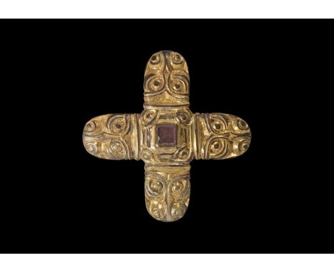
Lot 933
Later 6th-7th century AD. A silver sword mount formed as a central square panel with cell above, four beast-head arms; the cell with inset garnet cloison and crimped gold foil behind; the centre hollow with slider-bar to the reverse; each arm a stylised beast-head with bilinear collar, bilinear brow-ridge and nasal, pellet eyes and nostrils with bilinear frames. [A video of this lot is available on the TimeLine Auctions website] See Franceschi, G., Jorn, A. & Magnus, B. Mennesker, Guder og Masker i Nordisk Jernalderkunst, vol.1 Borgen, 2005; Hammond, B. British Artefacts vol.1 - Early Anglo-Saxon, Witham, 2009; Menghin, W. Das Schwert im Frühen Mittelalter, Stuttgart, 1983; Pollington, S., Kerr, L. & Hammond, B. Wayland's Work: Anglo-Saxon Art, Myth & Material Culture from the 4th to 7th century, Ely, 2010; Mortimer, P. Woden's Warriors. Warriors and Warfare in 6th-7th Century Northern Europe, Ely, 2011. 18 grams, 45mm (1 3/4"). Property of a European gentleman; acquired German in the late 1960s-early 1970s. Sword pyramids were once a very rare class of find, discovered only in very high-status burials such as Niederstotzingen (Germany), Sutton Hoo Mound 1 (Suffolk, England) and the Broomfield barrow (Essex, England"). Since the 1980s, a quantity of such finds have come to light and the object-class is now better understood. They are found predominantly in England, the Rhineland, central Europe and southern Scandinavia, and were a short-lived display item. The classic form is a truncated hollow gold (or silver, or bronze) pyramid with a bar to the reverse, inset garnet and glass plaques to the four faces and top (Pollington et al., fig.8.52 and plates 19 54 55; Hammond, p.73-4; Menghin, map 22"). Several variant forms do exist, such as the octagonal-base and the conical types (Hammond, 2009 item 1.4.2.2-f; Mortimer, 2011 p.117"). Another common Continental variant includes a flat-section rectangular plaque, as well as a form with curved edges to the plaque (Menghin, map 23"). The present example with four beast-heads is apparently unique, although it has parallels in later harness and other mounts. The beast-heads have close parallels on the headplate of a 6th c. silver bow-brooch from Stora Gairvide, Gotland (Franceschi et all, item 75) and on the footplate of another from a burial mound at Sandal, Norway (Franceschi et al., item 66"). The exact purpose of the pyramids is not known, but when they occur in graves they are usually placed in pairs high on the sword's scabbard (Menghin, p.150 and fig.90) which suggests that they were used in the suspension of the scabbard from its belt, or more evocatively in the fastening of textile 'peace-bands' which secured the sword in its scabbard and provided a very visible demonstration that the owner did not intend to draw it in haste (Mortimer, p.116"). Very fine condition.
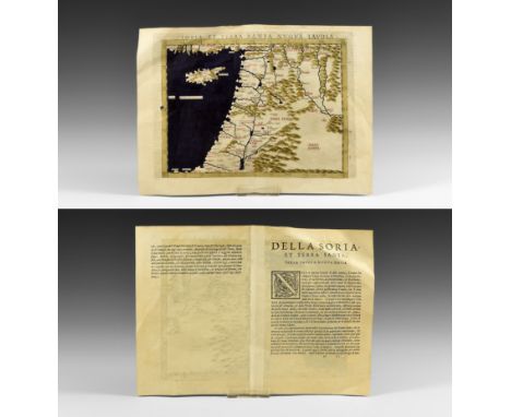
Lot 290
Published 1561 AD. Taken from La Geografia di Claudio Tolomeo Alessandrino, Venice, translated by Girolamo Ruscelli and Vincenzo Valgrisi as 'Nuouamente tradotta di Greco in Italiano'; comprises an original double-page with Latin text relating to the map to reverses with hand-coloured folding map titled SORIA ET TERRA SANTA NVOVA TAVOLA, also showing Cyprus and part of the eastern Mediterranean region, the border, water and hills coloured with red lining to most place names. See British Museum, General Catalogue of Printed Books to 1955 pp.334-344 for information on the issues of this work. 5.93 grams, 30x22cm (12 x 8 3/4"). Ex Swiss collection; acquired 1980s. Claudius Ptolemaeus (circa 100-170AD) was born in Alexandria and became one of the foremost scholars of his day as a geographer (he is sometimes known as the 'Father of Geography) and mathematician with his works being important for centuries after his death; in the Medieval period, his atlas was first published in Bologna in 1477; an incomplete copy of the 1561 edition containing fifty (of sixty-four) maps was sold by Christies, 10 October 2013 lot 68 and achieved a hammer price of 10000. Very fine condition. Rare.


Lot 289
A collection of 18th century and later book maps, including two county maps of Monmouthshire, one by Joseph Ellis from his English Atlas 1765 and the other from John Owen and Emanuel Bowen's Brittanica Depicta published 1720, plus later maps, coloured prints of Abergaveny, and 'The Hub' cycling map of England & Wales by George Newnes (12)

Lot 402
Judith Ackland (1892-1971), an Arts & Crafts fruit bowl, decorated with pen and ink island map, and tall ships at sea 23.5 cm dia.There are scratches throughout, some minor dents, the design is crazed all over.Some staining to the inside, otherwise generally good condition, no obvious signs of significant damage or repair

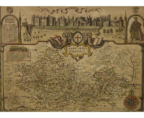
Lot 301
John Speed (1552-1629) 'Barkshire Described' Anno 1350 map of the count of Berkshire, Performed by I. Speede and are to be solde in Popes head Alley by I. Sud and George Humble London 1627 with a prospect of Windsor Castle and a list of the original knights of the Order of the Garter, with portrait of Edward III in the top right hand quarter who both founded the order and rebuilt Windsor during his reign. This example possibly engraved by Jodocus Hondius II 51 cm x 38 cm, framed and glazed


Lot 3710
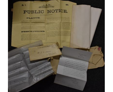
Colonial Medical History - British East Africa - Plague Epidemics - an interesting archive of letters, correspondence and ephemera relating to the career of James Augustine Haran, his studies in Dublin during the 1890's, his appointment as Medical Officer under the Administration of East Africa in February 1898 and subsequent research, notes and writings on plague in the region, including a hand traced map showing the Kisumu Plague 1905, a Public Notice dated 1908 letters between the Foreign Office and the Commissioner's Office Nairobi referring to the disease, a typed manuscript relating to treatment, vellum and paper certificates and many other personal papers
![John Speed (1551/52-1629), Darbieshire defcribed (sic, Derbyshire), text to verso, [London] 1666, two-page map, hand-coloured](https://cdn.globalauctionplatform.com/01ba2e64-7f3f-4569-93b6-a7c8007b75f2/9e36743b-5a4d-481e-88f2-22c3e4d8eadc/468x382.jpg)
![Black's Road & Railway Travelling Map of Scotland, engraved by S. Hall, Bury Str., Bloomsbury, [London], Published by A. & C.](https://cdn.globalauctionplatform.com/01ba2e64-7f3f-4569-93b6-a7c8007b75f2/1dff515b-44bf-4e59-87e8-0f21b598ff59/468x382.jpg)
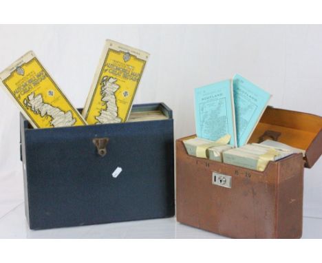
Lot 3666
Black's Road & Railway Travelling Map of Scotland, engraved by S. Hall, Bury Str., Bloomsbury, [London], Published by A. & C. Black, Edinburgh [1868-1870], thirty-six fold map with notice To Tourists panel, hand-coloured lithograph, each 14cm x 10.5cm panel laid on linen, 84cm x 63cm overall, contemporary green buckram as issued, the front board gilt embossed title within a scrolling rococo frame, with locomotive and stagecoach cresting and apron, yellow paper pastedown, 16mo


![Ephemera - sale/auction catalogue, Henry Spencer & Sons, Sutton Vicarage, 3 Miles from Retford, [Nottinghamshire], Friday, Oc](https://cdn.globalauctionplatform.com/01ba2e64-7f3f-4569-93b6-a7c8007b75f2/01c6c016-1700-438d-96a0-e3f9ca2b216b/468x382.jpg)
Lot 3718
Ephemera - sale/auction catalogue, Henry Spencer & Sons, Sutton Vicarage, 3 Miles from Retford, [Nottinghamshire], Friday, October 26th, 1917, 10pp, card boards; Bacon's County Map and Guide to Derbyshire, With Parts of Adjoining Counties, C.W. Bacon & Co., Ltd., London [c. 1900]; Motoring and Hiking Map, Section E [Midlands], c. 1920; miniature restrikes of the Daily Express; British Empire Exhibition - ink MS two-fold card-letter, addressed to The Directors of Messrs. Archibald Kenrick & Sons Ld., West Bromwich, dated 1924; books of classic verse, printed with chromolithographic flower's; stamps; copy books; ink MS; qty


Lot 3669
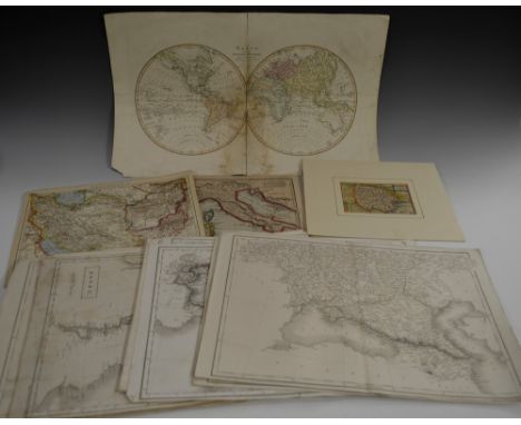
Maps - E. Borne (early 19th century), The World from the Discoveries & Observations made in the Latest Voyages & Travels, Published by Hamilton, Adams & Co., London [c. 1810], two-fold map, hand-coloured engraving, 33cm x 52cm; Ordnance Survey Maps - Northumberland - Morpeth, Tynemouth, Bellingham, Brampton, Rothbury, Norham, Frome, Durham, Hexham, Elsdon, [c. 1900] four-fold, 45.5cm x 61.5cm (10); early 19th century two-fold maps of Continental countries, monochrome engravings; others, late 17th century and later, including United Kingdom, Russia, Holy Land; qty
Lot 2542
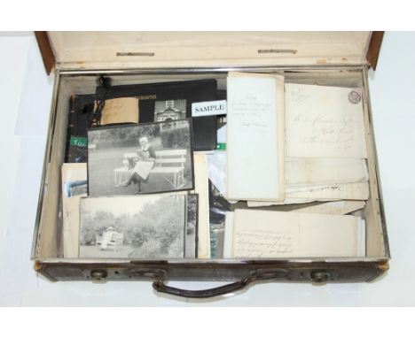
Mixed ephemera relating to Boxted, Essex - including an album of photographs of 'Clive's' Boxted, horse, family, garden and surrounding Stanfords Particulars of Clive's with plan and 1945 house furniture sale, Clive's Cottage and Farm Building map 1922, also letter, indentures, photographs, etc, relating to Boxted, plus a quantity of miscellaneous ephemera in a travel case

-
109198 item(s)/page